

The Native American Research Assistantship Program: Building Capacity for Indigenous Water-Resources Monitoring
Links
- Document: Report (5.13 MB pdf) , HTML , XML
- Download citation as: RIS | Dublin Core
Intertribal networks for collecting and analyzing hydrologic and environmental data are growing. Such networks collect, analyze, and store data for the benefit of Indigenous Peoples. For example, the Tribal Exchange Network Group, a partner of the U.S. Environmental Protection Agency, provides data management and analysis and data sharing opportunities between Tribal Nations (https://www.tribalexchangenetwork.org). All data networks benefit from the use of consistent data collection and analysis protocols and robust quality assurance and control processes, which ensure comparability across a range of conditions and locations. The U.S. Geological Survey (USGS), which has long experience in managing water-resources monitoring networks—following nationally consistent protocols—can be a key partner with Tribal Nations in the further development of network capacity. A collaboration between the Federal government and Tribal Nations serves to benefit both governments and their people. Indigenous People can learn how to apply consistent protocols to ensure the comparability of samples and data, collected within and among Nations and over time, from streams, watersheds, and aquifers. These data would help Indigenous water-resources managers find and apply solutions to the challenging water-related issues facing Tribal Nations today.
The USGS benefits in two ways. Building relationships with Native people facilitates incorporation of Indigenous Knowledge and expertise into ongoing efforts, including restoring and sustaining ecosystems. In working to support Indigenous data sovereignty, the USGS also complies with the Federal trust and treaty responsibilities to encourage Tribal self-governance and economic prosperity.
A first step in building strong relationships and working towards mutual goals is the internship opportunity available through the partnership between the USGS and The Wildlife Society: The Native American Research Assistantship Program (NARA). Summer 2023 was the first time the USGS hosted interns through this program, which matches Native American graduate or undergraduate students in the fields of natural resources and conservation with Federal scientists.
The U.S. Geological Survey (USGS) constructs, operates, and maintains nationwide water-resources networks. These networks are partly federally funded and partly supported by local cooperating agencies and are operated according to a set of nationally consistent protocols. These networks range from a subwatershed scale to a national scale. Network measurements include groundwater levels; streamflow; reservoir, lake, and estuary levels; water quality; and properties like turbidity, specific conductance, and water temperature. Time-series data collected by these networks can be used to forecast natural and human-induced changes to water and enable users to plan for potential water-related challenges. Collectively, USGS staff possess thousands of years of institutional knowledge and have the skills required to successfully operate and maintain local, State, and national data networks. These skills include construction, electronics, telemetry, hydrology, hydraulics, and water chemistry, to name a few.
In 2023, the USGS hosted three interns, including Electa Hare-Red Corn, a Native American student from the Pawnee Nation, who worked side by side with staff from the USGS New England and New York Water Science Centers (fig. 1). The internship included proper operation, maintenance, and calibration of equipment (groundwater observation wells, streamgages, water-quality sensors, and continuous water-quality stations), data collection (groundwater levels, streamflow, and water-quality samples), and data analysis (using USGS software to manipulate, graph, and present continuous time-series data). Hare-Red Corn also completed elevation surveys, which are critical to maintaining consistency of long-term records.
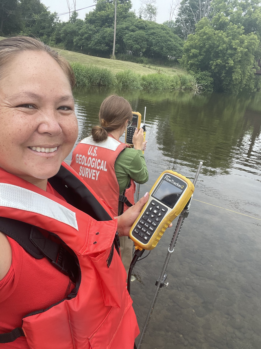
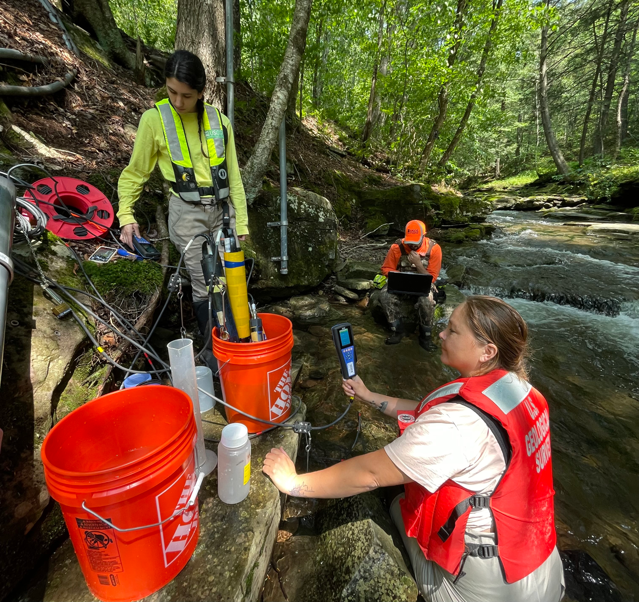
Electa Hare-Red Corn working with U.S. Geological Survey (USGS) staff to A, make a streamflow measurement at Cohocton River, Avoca, New York, (USGS station 01527500), B, check a groundwater-monitoring well, C, test new streamgaging methods at Biscuit Brook, Frost Valley, N.Y. (station 01434025), and D, conduct water-quality sensor maintenance at the Merrimack River estuary, Salisbury, Massachusetts (station 011008745). Photographs by the U.S. Geological Survey.
A visit to service streamgages in New York provided an opportunity for reflection (fig. 2). Streamgage 04238500 is situated on the Onondaga Nation and is funded by the U.S. Army Corps of Engineers. Prior to constructing this streamgage, USGS staff worked with Onondaga Nation Historic Preservation Officers as required by Section 106 of the National Historic Preservation Act (Public Law 89–665, 80 Stat. 915). The USGS notifies the staff at Haudenosaunee Environmental Task Force every time the USGS checks streamgages in the Onondaga Nation, which is part of the Haudenosaunee Confederacy, consisting of several clans, each led by its own Clan Mother.
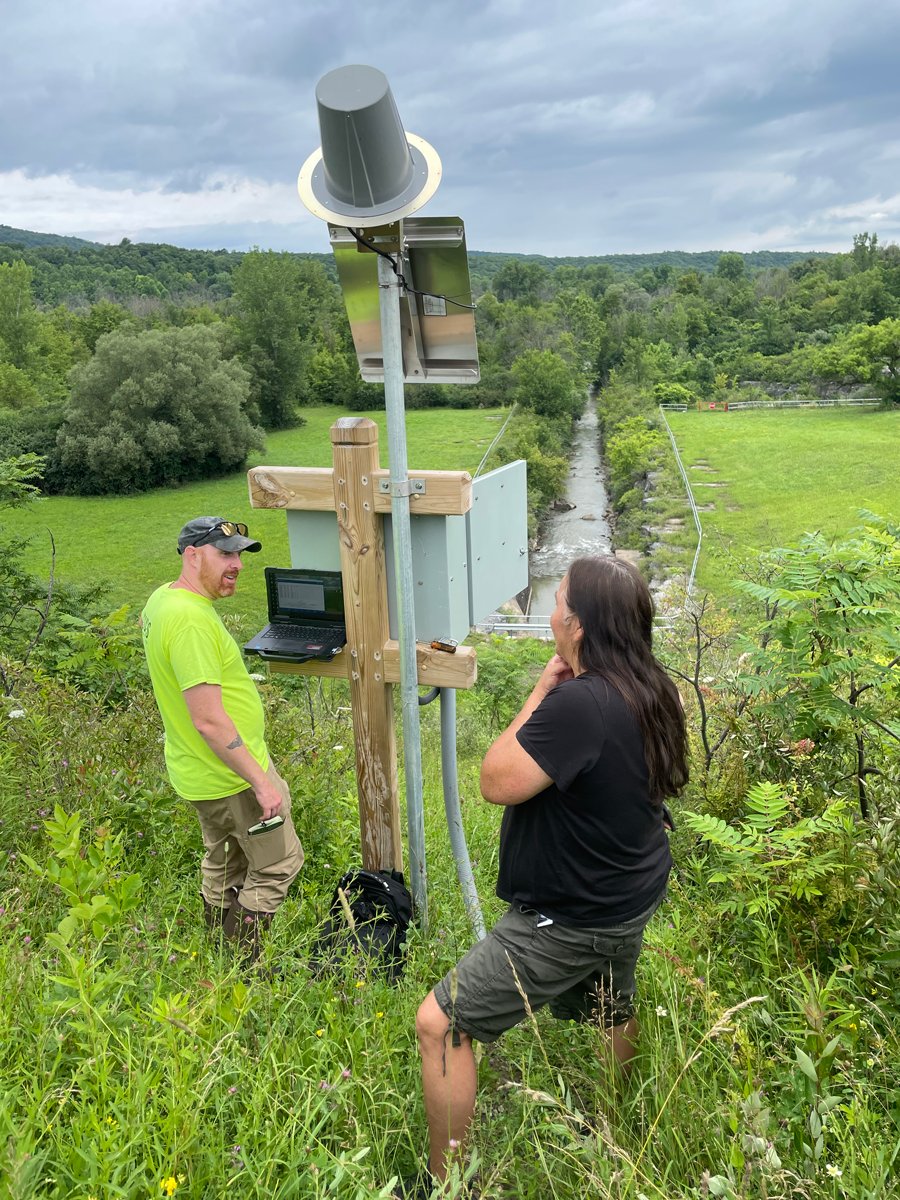
A member of the Onondaga Nation Haudenosaunee Environmental Task Force and a U.S. Geological Survey hydrologic technician examine a streamgage on Onondaga Creek during a visit with Electa Hare-Red Corn (not shown). Photograph by the U.S. Geological Survey.
The Haudenosaunee have a unique relationship with water. They take personal responsibility to ensure that water is pristine and that its voice is heard. The Haudenosaunee believe that, at one time, water could speak for itself, but now it appears to have lost its voice. The Haudenosaunee believe that now it is their responsibility to speak for water (King, 2007). By sharing technical capabilities and expertise through initiatives such as the NARA program, the USGS aims to support priorities of Indigenous partners, including the Haudenosaunee.
Reference Cited
King, J.T., 2007, The value of water and the meaning of water law for the Native Americans known as the Haudenosaunee: Cornell Journal of Law and Public Policy, v. 16, no. 3, p. 449–472, accessed on August 12, 2023, at https://scholarship.law.cornell.edu/cjlpp/vol16/iss3/1.
For more information, contact:
Director, New York Water Science Center
dc_ny@usgs.gov
https://www.usgs.gov/centers/new-york-water-science-center
Publishing support provided by the Pembroke Publishing Service Center
Disclaimers
Any use of trade, firm, or product names is for descriptive purposes only and does not imply endorsement by the U.S. Government.
Although this information product, for the most part, is in the public domain, it also may contain copyrighted materials as noted in the text. Permission to reproduce copyrighted items must be secured from the copyright owner.
Suggested Citation
Hare-Red Corn, E., Breault, R.F., and Sorenson, J.R., 2024, The Native American Research Assistantship Program—Building capacity for Indigenous water-resources monitoring: U.S. Geological Survey Fact Sheet 2024–3026, 2 p., https://doi.org/10.3133/fs20243026.
ISSN: 2327-6932 (online)
| Publication type | Report |
|---|---|
| Publication Subtype | USGS Numbered Series |
| Title | The Native American Research Assistantship Program—Building capacity for Indigenous water-resources monitoring |
| Series title | Fact Sheet |
| Series number | 2024-3026 |
| DOI | 10.3133/fs20243026 |
| Publication Date | July 23, 2024 |
| Year Published | 2024 |
| Language | English |
| Publisher | U.S. Geological Survey |
| Publisher location | Reston, VA |
| Contributing office(s) | New England Water Science Center, New York Water Science Center |
| Description | 2 p. |
| Online Only (Y/N) | Y |
| Additional Online Files (Y/N) | N |