

The 3D Elevation Program—Supporting Michigan’s Economy
Links
- Document: Report (693 KB pdf) , HTML , XML
- Download citation as: RIS | Dublin Core
Introduction
High-quality elevation data are proving to be a resource of value in addressing many important economic issues in Michigan. The expanding statewide availability of current and accurate high-resolution elevation data can help support agriculture and precision farming, natural resource conservation, flood risk management, and geologic resource assessment and hazard mitigation. Water supply and quality assessment, coastal zone management, infrastructure and construction management, solar potential and other renewable energy programs, and identification of features of interest or concern such as archaeological and historical sites are other notable areas that are supported with accurate, high-resolution elevation data. Critical applications that meet the State’s management needs depend on light detection and ranging (lidar) data that provide a highly detailed three-dimensional (3D) model of the Earth’s surface and aboveground features.
The 3D Elevation Program (3DEP; refer to sidebar) is managed by the U.S. Geological Survey (USGS) in partnership with Federal, State, Tribal, U.S. territorial, and local agencies to acquire consistent lidar coverage at quality level 2 or better (table 1) to meet the many needs of the Nation and Michigan. The status of available and in-progress 3DEP baseline lidar data in Michigan is shown in figure 1. 3DEP baseline lidar data include quality level 2 or better, 1-meter or better digital elevation models, and lidar point clouds, and must meet the Lidar Base Specification version 1.2 (https://www.usgs.gov/3dep/lidarspec) or newer requirements. The National Enhanced Elevation Assessment (Dewberry, 2012) identified user requirements and conservatively estimated that availability of lidar data would result in at least $10.19 million in new benefits annually to the State. The top 10 Michigan business uses for 3D elevation data, which are based on the estimated annual conservative benefits of 3DEP, are shown in table 2.
Table 1.
Data quality levels, pulse spacing, and pulse density. Quality level 2 or better lidar data meet 3DEP requirements.[Specifications for quality level 0 (QL0) are from Heidemann (2012, p. 3 and table 1); for quality levels 1 and 2, specifications are from Sugarbaker and others (2014, table 1). In the quality level column, QL0 represents the highest level of quality. RMSEz, root mean square error in the elevation (z) dimension; cm, centimeter; m, meter; pls/m2, first return pulses per square meter; ≤, less than or equal to; ≥, greater than or equal to]
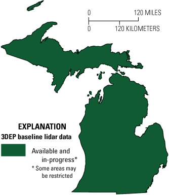
Map of Michigan showing status of 3D Elevation Program (3DEP) baseline lidar data as of March 2024. Visit https://usgs.gov/NationalMap/LidarExplorer to find and download currently available data.
Table 2.
Conservative benefits estimates for the top 10 Michigan business uses of the proposed 3DEP data identified in the National Enhanced Elevation Assessment (Dewberry, 2012).Status of 3DEP in Michigan
The State of Michigan, Department of Technology, Management and Budget (DTMB), Center for Shared Solutions coordinates funding and support for 3DEP from the Federal Emergency Management Agency, the Natural Resources Conservation Service (U.S. Department of Agriculture), the U.S. Forest Service, the USGS, and State and local agencies. Through the Michigan Statewide Authoritative Imagery & Lidar (MiSAIL) Program (Michigan Department of Technology, Management and Budget, 2020), Michigan has recently completed acquisition of statewide 3DEP data (fig. 1) at quality level 2. Updating the current data and improving resolution can help to support a variety of initiatives throughout Michigan.
In 2021, DTMB launched a program to update their statewide hydrography dataset using digital elevation models based on their completed quality level 2 dataset. This updated hydrography utilizes USGS specifications for terrain-based hydrography delineation (Terziotti and Archuleta, 2020; Archuleta and Terziotti, 2020). When completed, the project will provide an improved, consistently derived representation of Michigan’s hydrographic features.
Agriculture and Precision Farming
Approximately 28 percent of the land area of Michigan is devoted to agricultural uses. Lidar data can provide a more accurate depiction of terrain and improve precision farming activities, which helps improve crop yields, prevent soil degradation, and reduce agricultural chemical runoff—factors that help farmers realize a larger return on their investments.
Natural Resources Conservation
The Michigan Department of Natural Resources is engaged in the conservation, protection, and management of the State’s natural and cultural resources for current and future generations. Lidar data enable State and local governments and planning and development regions to reduce fieldwork for conservation projects such as grade stabilization, ponds, grassed waterways, terracing, and wetland delineation and restoration, thus reducing costs to the public.
Flood Risk Management
Frequent flooding in the Midland area is a major concern (fig. 2). Following multiple dam failures on the Tittabawassee River and the related loss of two lakes in May 2020, new quality level 1 data were acquired for the area using MiSAIL lidar with support from State and local governments and planning and development regions. Lidar data provide high-quality terrain information as input for more accurate and less expensive hydrologic and hydraulic modeling for flood studies, retention-dam design, dam breach studies, and stormwater management and engineering. This information can be used to identify vulnerable properties within a flood plain, facilitate better flood-plain management decisions, and educate the public on flood risk zones by providing dynamic 3D models to show the potential impact of flooding from major storm events.
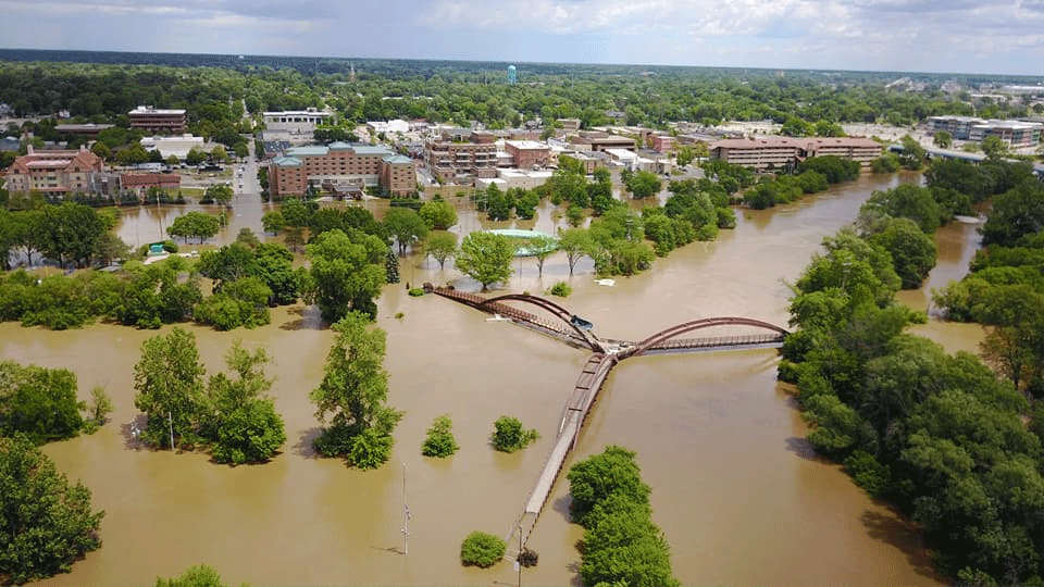
Aerial view of Midland, Aerial view of Midland, Michigan, during flooding of the Tittabawassee River in 2016. Photograph by the Midland Daily News; courtesy of Michigan State Police.
Geologic Resource Assessment and Hazard Mitigation
Subtle features not evident on conventional USGS topographic maps (or aerial photography) are often readily apparent on lidar images (fig. 3). The availability of lidar data has fundamentally changed how geological mapping and geological resource evaluations are conducted.
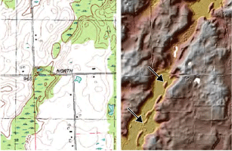
Lidar data provide a more detailed view of the landscape and reveal subtle features not evident on traditional U.S. Geological Survey 7.5-minute topographic maps (left). These features, such as the glacial esker deposits trending southwest to northeast on the lidar shaded relief map of the same area in Calhoun County (right; see arrows), are often the source of economically important gravel deposits. Images courtesy of Michigan Geological Survey.
3D Elevation Program (3DEP)
The 3D Elevation Program is managed by the U.S. Geological Survey (USGS) on behalf of the community of Federal, State, Tribal, local, and other partners and users of elevation data. In response to growing needs for high-quality elevation data, the goal of 3DEP is to complete acquisition of nationwide light detection and ranging (lidar) data (interferometric synthetic aperture radar [IfSAR] data in Alaska) to provide the first-ever national baseline of consistent, high-resolution topographic elevation data—both bare-earth digital elevation models and 3D point clouds.
Benefits
-
• Economies of scale by acquiring data for larger areas.
-
• Predictable and flexible Federal investments that can reduce costs and allow better planning.
-
• Consistent national coverage that provides data for applications that span project, jurisdictional, and watershed boundaries.
-
• Simplified data acquisition that provides contracts, project management, quality assurance, and published data specifications.
-
• National benefits of $690 million per year conservatively, with the potential to generate $13 billion per year in additional benefits through applications that span the economy (Dewberry, 2012).
High-Quality Data and Products
3DEP lidar data provide coverage with a minimum of two points per square meter and a vertical error not to exceed 10 centimeters, measured as root mean square error in the elevation (z) dimension (RMSEz) (table 1). 3DEP baseline lidar data products include all data points collected (point clouds) and bare-earth digital elevation models with a 1-meter or better resolution. The USGS integrates the elevation data into The National Map. Data are available free of charge and without use restrictions. To download 3DEP products visit https://apps.nationalmap.gov/downloader/.
Ways to Participate
Participation in 3DEP is open to Federal, State, Tribal, U.S. territorial, and local government partners, as well as private sector partners, and offers the option to acquire even higher quality data. Partners may contribute funds toward projects managed by the USGS, or they may receive cooperative funds to manage their own projects. An annual Data Collaboration Announcement is the mechanism used to establish partner agreements. Organizations and the private sector may contribute existing data that meet 3DEP requirements. For more information refer to the 3DEP website at https://www.usgs.gov/3DEP/collaborate/.
References Cited
Archuleta, C.M., and Terziotti, S., 2020, Elevation-derived hydrography—Representation, extraction, attribution, and delineation rules (ver.1.1, March 2024): U.S. Geological Survey Techniques and Methods, book 11, chap. B12, 60 p., accessed March 18, 2024, at https://doi.org/10.3133/tm11B12.
Dewberry, 2012, National Enhanced Elevation Assessment final report (revised March 29, 2012): Fairfax, Va., Dewberry, 84 p. plus appendixes, accessed March 18, 2024, at https://www.dewberry.com/services/geospatial/national-enhanced-elevation-assessment.
Heidemann, H.K., 2012, Lidar base specification (ver. 1.2, November 2014): U.S. Geological Survey Techniques and Methods, book 11, chap. B4, 67 p. with appendixes, accessed March 18, 2024, at https://doi.org/10.3133/tm11B4.
Michigan Department of Technology, Management and Budget [DTMB], 2020, Michigan Statewide Authoritative Imagery & LiDAR Program (MiSAIL): Michigan DTMB website, accessed October 28, 2020, at https://www.michigan.gov/dtmb/services/maps/misail.
Sugarbaker, L.J., Constance, E.W., Heidemann, H.K., Jason, A.L., Lukas, V., Saghy, D.L., and Stoker, J.M., 2014, The 3D Elevation Program initiative—A call for action: U.S. Geological Survey Circular 1399, 35 p., accessed March 18, 2024, at https://doi.org/10.3133/cir1399.
Terziotti, S., and Archuleta, C.M., 2020, Elevation-derived hydrography acquisition specifications: U.S. Geological Survey Techniques and Methods, book 11, chap. B11, 74 p., accessed March 18, 2024, at https://doi.org/10.3133/tm11B11.
For Further Information:
Director, National Geospatial Program
U.S. Geological Survey, MS 511
12201 Sunrise Valley Drive
Reston, VA 20192
Email: 3DEP@usgs.gov
USGS National Map Liaison:
Cynthia Rachol; Email: crachol@usgs.gov
By Cynthia Rachol
Disclaimers
Any use of trade, firm, or product names is for descriptive purposes only and does not imply endorsement by the U.S. Government.
Although this information product, for the most part, is in the public domain, it also may contain copyrighted materials as noted in the text. Permission to reproduce copyrighted items must be secured from the copyright owner.
Suggested Citation
Rachol, C.M., 2024, The 3D Elevation Program—Supporting Michigan’s economy: U.S. Geological Survey Fact Sheet 2024-3031, 2 p., https://doi.org/10.3133/fs20243031.
ISSN: 2327-6932 (online)
ISSN: 2327-6916 (print)
Study Area
| Publication type | Report |
|---|---|
| Publication Subtype | USGS Numbered Series |
| Title | The 3D Elevation Program—Supporting Michigan’s economy |
| Series title | Fact Sheet |
| Series number | 2024-3031 |
| DOI | 10.3133/fs20243031 |
| Publication Date | July 24, 2024 |
| Year Published | 2024 |
| Language | English |
| Publisher | U.S. Geological Survey |
| Publisher location | Reston, VA |
| Contributing office(s) | National Geospatial Program |
| Description | 2 p. |
| Country | United States |
| State | Michigan |
| Online Only (Y/N) | N |
| Additional Online Files (Y/N) | N |