

Earth Observation Remote Sensing Tools—Assessing Systems, Trends, and Characteristics
Links
- Document: Report (2 MB pdf) , HTML , XML
- Download citation as: RIS | Dublin Core
Abstract
With the ever-increasing number of civil and commercial remote-sensing satellite launches in recent years, the Earth Observation community needs to better understand the quality of new data products as they become available for scientific research purposes.
Earth Observing Satellites Online Compendium
Produced by U.S. Geological Survey (USGS), in collaboration with the Joint Agency Commercial Imagery Evaluation (JACIE), the Earth Observing Satellites Online Compendium (Clauson and others, 2024) provides a web-accessible database that contains detailed technical information concerning past, current, and future remote sensing satellites, and via an interactive form, enables users to submit satellite sensor queries with search criteria that includes spectral resolution, data availability, launch year, and basic system specifications.
The Online Compendium also provides links to all JACIE assessments of orbiting systems, which allows scientists and other users to independently verify image data availability and quality. Frequent updates document the latest capabilities in a rapidly expanding satellite remote sensing industry, and scientists and operational users from various disciplines can use the online version to identify data assets best suited to meet their needs (https://www.usgs.gov/tools/earth-observing-satellites-online-compendium).
The main page of the Online Compendium includes filters (fig. 1) and displays the following satellite parameters: Name, Status, Orbit, Launch year, Country, Spectral bands, Range (nanometer), Radar Bands, Ground Sample Distance (GSD), Sensing Element Type, Sensor Name, Data Cost and Policy and Satellite Associations. The tool reports the satellite list by using either the search tab or the filters.
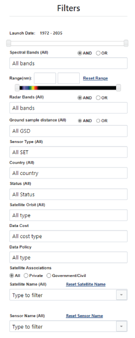
Online Compendium filter page.
Clicking the magnifier symbol in the Details column displays a popup page (fig. 2) that contains more information about the selected satellite and the sensors carried on that satellite, including a description of the satellite, life span, country of ownership, orbit details, sensor description, sensor specifications, spectral bandwidths, radar bands, revisit, data policy and cost, and links to additional resources. The Export feature on the top right of the Details column can be used to return a list of selected satellites as an excel spreadsheet (fig. 3).
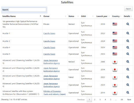
Online Compendium Satellite page.
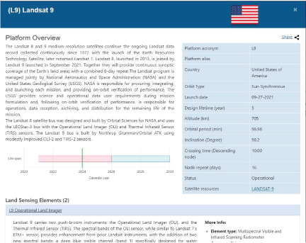
Online Compendium Platform Overview page.
Spectral Characteristics Viewer
The Earth Resources Observation and Science (EROS) Cal/Val Center of Excellence (ECCOE) Spectral Characteristics Viewer (https://landsat.usgs.gov/spectral-characteristics-viewer) provides the capability to compare and contrast the relative spectral responses (RSRs) from different Earth observation systems and spectral libraries. The ECCOE Spectral Characteristics Viewer allows users to evaluate which satellite bands may be best suited for their research application and provides detailed information about the spectral bands and the RSRs of a growing number of key civil and commercial sensors. Users can select one or more sensors of interest and display the relative spectral response curves on a viewer for comparison. Users can export the RSRs for further analysis of the individual satellite systems. The viewer also can be used to display and compare satellite RSRs to spectral data from the USGS Spectroscopy Laboratory and the ECOSTRESS Spectral Library. The current (2024) application includes a sensor library, target library (fig. 4), and response calculation. The viewer includes sensor and target spectral information in the following ranges: Visible to Short Wavelength InfraRed (VSWIR; 0.38–2.51 micrometers [μm]), thermal infrared (TIR; 2.51–14.0 μm), and VSWIR+TIR, 0.38–14.0 μm). Note that the tool is meant for “quick looks” and not mission design or detailed scientific analysis (https://landsat.usgs.gov/spectral-characteristics-viewer; figs. 5, 6, 7, 8).
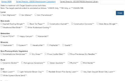
Target Spectra Library.
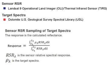
Sensor relative spectral response (RSR)—Sampling of target spectra.
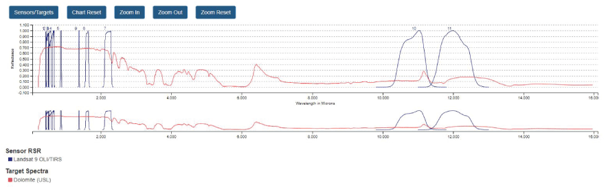
The Spectral Characteristics Viewer showing a comparison between a sensor relative spectral response (RSR) and a target spectra.
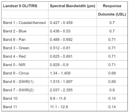
The Spectral Characteristics Viewer showing response computation for Landsat 9 sampling the dolomite target.
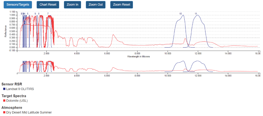
The Spectral Characteristics Viewer showing the response computation for Landsat 9 sampling the dolomite target and dry desert, mid-latitude and mid-summer atmosphere.
The planned enhancements to the application include expansion of the sensor and target libraries and expansion of the atmospheric library.
Acknowledgments
This work was funded by the U.S. Geological Survey’s National Land Imaging Program (https://www.usgs.gov/programs/national-land-imaging-program), and work was completed by the Earth Resources Observation and Science (EROS) Cal/Val Center of Excellence (ECCOE) Project team (https://www.usgs.gov/calval).
Reference Cited
Clauson, J., Cantrell, S., Vrabel, J., Oeding, J., Ranjitkar, B., Rusten, T., Ramaseri, S., and Casey, K., 2024, Earth Observing Satellites Online Compendium: U.S. Geological Survey digital data, https://calval.cr.usgs.gov/apps/compendium.
For more information contact:
U.S. Geological Survey, Earth Resources Observation and Science (EROS)
EROS Cal/Val Center of Excellence (ECCOE) Project team
47914 252nd Street
Sioux Falls, SD 57198
Email: eccoe@usgs.gov
Disclaimers
Any use of trade, firm, or product names is for descriptive purposes only and does not imply endorsement by the U.S. Government.
Although this information product, for the most part, is in the public domain, it also may contain copyrighted materials as noted in the text. Permission to reproduce copyrighted items must be secured from the copyright owner.
Suggested Citation
Cantrell, S., Clauson, J., and Anderson, C., 2024, Earth observation remote sensing tools–Assessing systems, trends, and characteristics: U.S. Geological Survey Fact Sheet 2024–3040, 2 p., https://doi.org/10.3133/fs20243040.
ISSN: 2327-6932 (online)
| Publication type | Report |
|---|---|
| Publication Subtype | USGS Numbered Series |
| Title | Earth observation remote sensing tools—Assessing systems, trends, and characteristics |
| Series title | Fact Sheet |
| Series number | 2024-3040 |
| DOI | 10.3133/fs20243040 |
| Publication Date | October 11, 2024 |
| Year Published | 2024 |
| Language | English |
| Publisher | U.S. Geological Survey |
| Publisher location | Reston, VA |
| Contributing office(s) | Earth Resources Observation and Science (EROS) Center |
| Description | 2 p. |
| Online Only (Y/N) | Y |