topoBuilder Quick Start Guide
Links
- Document: Report (2.6 MB pdf) , HTML , XML
- Download citation as: RIS | Dublin Core
Acknowledgments
We thank Kelly Meehan of the U.S. Forest Service for her assistance with reviewing a draft of this Fact Sheet.
Abstract
TopoBuilder is a public web application from the National Geospatial Program that enables anyone to create customized digital U.S. Geological Survey (USGS) topographic maps, called OnDemand Topos, with the best available, most up-to-date data from The National Map (nationalmap.gov). OnDemand Topos can be made at different scales or quadrangles and can cover anywhere within the United States and its territories.
Step 1: Choose Map Type
In your browser, go to topoBuilder.NationalMap.gov and choose an OnDemand Topo type in the “Map Types” panel, then click the “Next” button.
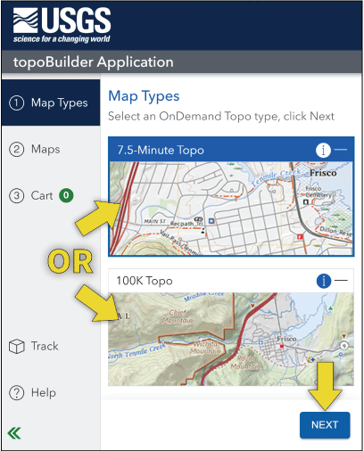
Step 1: Choose the map type by clicking on it, then click the “Next” button.
Step 2: Choose Map Extent
Pan and zoom the basemap or use the search box to locate an address or place.
Click “Select by Grid(s)” to create a map on the predefined USGS grid or “Custom Select” to create a map centered on the mouse cursor. Use the “Move” button to adjust the location of the map extent after creating it.
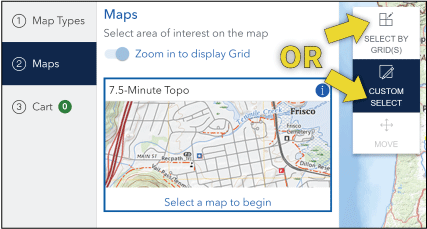
Step 2: Choose the map extent and (or) center point.
Step 3: Customize the Map
Edit the included data layers, choose the output format, and for 7.5-Minute Topo maps, adjust the contour smoothing.
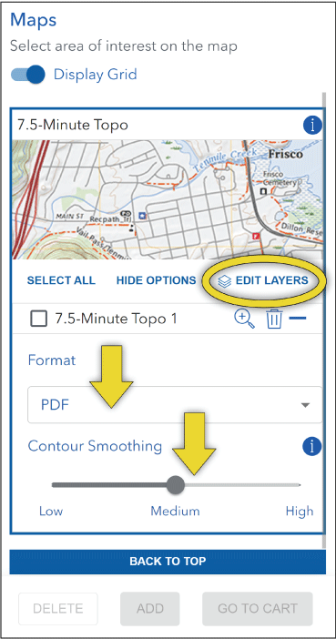
Step 3: Customize the map layers, format, and contour smoothing.
Step 4: Add to Cart
Click the checkbox by the map title, then click “Add.” For multiple maps, click “Select All” and then “Add.” Then click “Go To Cart.”
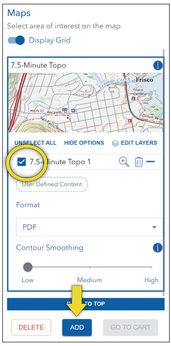
Step 4: Add the map(s) to the Cart.
Step 5: Checkout
Click “Checkout” and enter an email address in the dialog box. An order confirmation and download link(s) will be sent to that address.
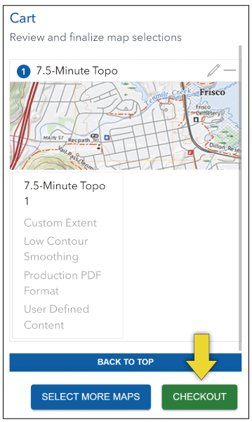
Step 5: Checkout all maps in the Cart.
Getting Help with topoBuilder
Click the “Help” icon in the left sidebar for help with topoBuilder and OnDemand Topo maps or email tnm_help@usgs.gov.
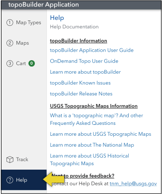
Getting help with topoBuilder.
About topoBuilder and OnDemand Topos
TopoBuilder is a new way to make topo maps anywhere in the United States and territories. Expertise or special software is not needed—topoBuilder is all in the web browser. TopoBuilder is free to use and creates digital maps called “OnDemand Topos.”
As of 2024, OnDemand Topos are available in 7.5-Minute Topo (1:24,000 scale within the continental United States) and 100K Topo (1:100,000 scale). Additional map types and customizations are in development.
7.5-Minute Topos cover approximately 50 square miles and are ideal for recreation, orienteering and geocaching, city planning, search and rescue, and scientific field work. 100K Topos cover approximately 1,500–2,200 square miles and are suitable for land management and general planning purposes. Each map can include contour lines, shaded relief (7.5-Minute Topo only), surface-water features, geographic names, structures, boundaries, transportation, land cover, and aerial imagery (7.5-Minute Topo only). Any combination of these layers can be customized in the map.
OnDemand Topos are similar in style to US Topo maps and are delivered as digital geospatial Portable Document Format (PDF) or GeoTIFF files. For additional topoBuilder and OnDemand Topo resources, visit usgs.gov/topoBuilder. Learn more about US Topo and other USGS topographic maps at usgs.gov/TopoMaps.
For more information contact:
Director, National Geospatial Program
U.S. Geological Survey, MS 511
12201 Sunrise Valley Drive
Reston, VA 20192
Publishing support provided by the Science Publishing Network,
Reston and Sacramento Publishing Service Centers
Disclaimers
Any use of trade, firm, or product names is for descriptive purposes only and does not imply endorsement by the U.S. Government.
Although this information product, for the most part, is in the public domain, it also may contain copyrighted materials as noted in the text. Permission to reproduce copyrighted items must be secured from the copyright owner.
Suggested Citation
Guidero, E.M., Doumbouya, A.T., Adkins, K.F., and Urban-Mathieux, B., 2024, topoBuilder quick start guide: U.S. Geological Survey Fact Sheet 2024–3041, 2 p., https://doi.org/10.3133/fs20243041.
ISSN: 2327-6932 (online)
| Publication type | Report |
|---|---|
| Publication Subtype | USGS Numbered Series |
| Title | topoBuilder quick start guide |
| Series title | Fact Sheet |
| Series number | 2024-3041 |
| DOI | 10.3133/fs20243041 |
| Publication Date | December 18, 2024 |
| Year Published | 2024 |
| Language | English |
| Publisher | U.S. Geological Survey |
| Publisher location | Reston, VA |
| Contributing office(s) | National Geospatial Program |
| Description | 2 p. |
| Online Only (Y/N) | Y |


