Using Citizen Scientists to Collect Oxygen and Hydrogen Isotope Data in Southern Nevada
Links
- Document: Report (2 MB pdf) , HTML , XML
- NGMDB Index Page: National Geologic Map Database Index Page
- Download citation as: RIS | Dublin Core
What is Citizen Science?
Citizen science programs provide a means for Federal and non-Federal government agencies to make science more engaging, transparent, and accessible by partnering with the public for the purpose of problem solving, data collection, and monitoring. Public volunteers become directly involved in local research, thereby engaging in scientific projects. The public has already been included in existing citizen science programs that cover a broad range of disciplines, such as ecology, hydrology, and tectonics. Citizen science advances research while simultaneously fostering a sense of involvement and interest from the public.
Beginning in 2017, the U.S. Geological Survey (USGS), U.S. Forest Service, Bureau of Land Management, U.S. Fish and Wildlife Service, and National Park Service collaborated with private, non-profit partners to inventory, survey, and rehabilitate springs in Clark County, Nevada. The USGS maintains the National Water Information System (NWIS), a publicly available online database of water-resources data for the Nation, and the agency is interested in using citizen science to add geochemical data from springs in southern Nevada.
From 2021 to 2023, the USGS directly worked with citizen science partners, including the Springs Stewardship Institute and the Friends of Nevada Wilderness, to collect stable isotope and tritium samples from southern Nevada springs. The citizen science volunteers were provided the training and supplies for proper sample collection by USGS staff. As the citizen science partners traveled and hiked to the remote spring sites to complete spring surveys and perform restoration activities, they collected stable isotope and tritium samples for the USGS. Samples were shipped to national USGS laboratories for analysis, and the results were uploaded to the NWIS database (U.S. Geological Survey, 2024).
How Will Scientists Use the Data?
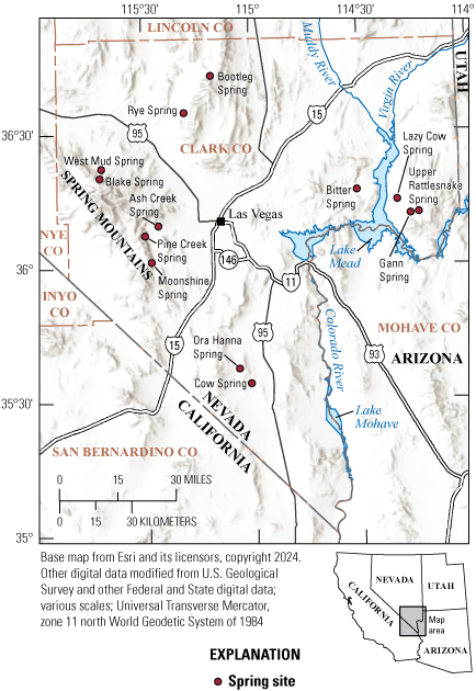
Springs are fed by groundwater, making them useful natural sites to study the subsurface movement of water (Manga, 2001; fig. 1). Isotopes are variations of the same chemical element; however, the atomic weight changes with different numbers of neutrons (Sulzman, 2007). Stable isotopes do not undergo radioactive decay over time and include isotopes of oxygen (oxygen-18, oxygen-16) and hydrogen (hydrogen-2, hydrogen-1). Differences in the ratios of stable isotopes of oxygen and of hydrogen can be used to help identify groundwater sources (McGuire and McDonnell, 2007). Tritium (hydrogen-3) is an unstable isotope of hydrogen, meaning that it undergoes radioactive decay over time into helium (helium-3). Nuclear weapons testing in the mid-20th century caused a spike in tritium (introduced into the hydrologic cycle) many times greater than the natural production rate (Michel and others, 2018). Using knowledge of atmospheric tritium concentrations over time and its decay rate, the amount of tritium in a sample aids in determining the age and sources of groundwater (Plummer and Friedman, 1999).

Location of southern Nevada springs visited and sampled by citizen science participants from 2021 to 2023.
What Were the Results of the Project?
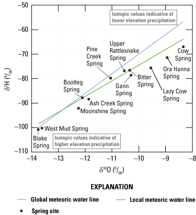
The stable isotope ratios and tritium levels of each spring site are shown in table 1. Data are accessible through the NWIS database using the Water Quality Portal (https://www.waterqualitydata.us/). Higher tritium concentrations generally indicate younger water that was recharged by more recent precipitation. Depleted stable isotope ratios (more negative) generally mean the spring water was recharged at a higher elevation or colder climate than less depleted water (fig. 2).
Table 1.
Stable isotope ratios and tritium levels of spring sites (U.S. Geological Survey, 2024).[ID, identification; TU, tritium unit; δ2H, hydrogen stable isotope ratio; δ18O, oxygen stable isotope ratio]

Plot of delta deuterium against delta oxygen-18 in parts per mil (parts per thousand relative to Vienna Standard Mean Ocean Water) of spring sites (red circles; U.S. Geological Survey, 2024), global meteoric water line (blue line [δ2H=8∙δ18O+10]; Craig, 1961), and local meteoric water line (green line [δ2H=6.4∙δ18O−10.5]; Moscati and Scofield, 2011).
How Can I Get Involved in Citizen Science?
The USGS has partnered with the public for a variety of water-resources and ecological projects. Visit the following link to find a project that interests you today!https://www.usgs.gov/youth-and-education-in-science/citizen-science
Acknowledgments
The U.S. Geological Survey would like to acknowledge the volunteers who gave their time to collect samples for this project. This work was funded by the Southern Nevada Public Lands Management Act (SNPLMA Project 17-1) through an agreement with the Bureau of Land Management. This research was supported in part by Oak Ridge Institute for Science and Education's Bromery Internship sponsored by the U.S. Department of Interior. Any use of trade, firm, or product names is for descriptive purposes only and does not imply endorsement by the U.S. Government.
References Cited
Craig, H., 1961, Isotopic variations in meteoric waters: Science, v. 133, no. 3465, p. 1702–1703, accessed August 21, 2024, at https://doi.org/10.1126/science.133.3465.1702.
Manga, M., 2001, Using springs to study groundwater flow and active geologic processes: Annual Review of Earth and Planetary Sciences, v. 29, p. 201–228, accessed July 31, 2024, at https://doi.org/10.1146/annurev.earth.29.1.201.]
McGuire, K. and McDonnell, J., 2007, Stable isotope tracers in watershed hydrology, chap. 11 of Michener, R., and Lajtha, K., eds., Stable isotopes in ecology and environmental science (2d ed.): Malden, Mass., Blackwell Publishing, p. 334–374. [Available at https://doi.org/10.1002/9780470691854.ch11.]
Michel, R.L., Jurgens, B.C., and Young, M.B., 2018, Tritium deposition in precipitation in the United States, 1953–2012: U.S. Geological Survey Scientific Investigations Report 2018–5086, 11 p., accessed July 31, 2024, at https://doi.org/10.3133/sir20185086.
Moscati, R.J., and Scofield, K.M., 2011, Meteoric precipitation at Yucca Mountain, Nevada—Chemical and stable isotope analyses, 2006–09: U.S. Geological Survey Scientific Investigations Report 2011–5140, 16 p., accessed August 20, 2024, at https://doi.org/10.3133/sir20115140.
Plummer, N., and Friedman, L.C., 1999, Tracing and dating young ground water: U.S. Geological Survey Fact Sheet 134–99, 4 p., accessed July 31, 2024, at https://doi.org/10.3133/fs13499.
Sulzman, E.W., 2007, Stable isotope chemistry and measurement—A primer, chap. 1 of Michener, R., and Lajtha, K., eds., Stable isotopes in ecology and environmental science (2d ed.): Malden, Mass., Blackwell Publishing, p. 1–21, accessed July 31, 2024, at https://doi.org/10.1002/9780470691854.ch1.
U.S. Geological Survey, 2024, USGS water data for the Nation: U.S. Geological Survey National Water Information System database, accessed October 17, 2024, at https://doi.org/10.5066/F7P55KJN.
For more information concerning the research in this report, contact the
Director, Nevada Water Science Center
U.S. Geological Survey
2730 North Deer Run Road
Carson City, NV 89701
https://www.usgs.gov/centers/nevada-water-science-center
Publishing support provided by the Science Publishing Network,
Sacramento Publishing Service Center
Disclaimers
Any use of trade, firm, or product names is for descriptive purposes only and does not imply endorsement by the U.S. Government.
Although this information product, for the most part, is in the public domain, it also may contain copyrighted materials as noted in the text. Permission to reproduce copyrighted items must be secured from the copyright owner.
Suggested Citation
Gonzales, J.M., Earp, K.J., and Cromratie Clemons, S.K., 2024, Using citizen scientists to collect oxygen and hydrogen isotope data in southern Nevada: U.S. Geological Survey Fact Sheet 2024–3042, 2 p., https://doi.org/10.3133/fs20243042.
ISSN: 2327-6932 (online)
Study Area
| Publication type | Report |
|---|---|
| Publication Subtype | USGS Numbered Series |
| Title | Using citizen scientists to collect oxygen and hydrogen isotope data in southern Nevada |
| Series title | Fact Sheet |
| Series number | 2024-3042 |
| DOI | 10.3133/fs20243042 |
| Publication Date | November 25, 2024 |
| Year Published | 2024 |
| Language | English |
| Publisher | U.S. Geological Survey |
| Publisher location | Reston, VA |
| Contributing office(s) | Nevada Water Science Center |
| Description | 2 p. |
| Country | United States |
| State | Nevada |
| Online Only (Y/N) | Y |


