

Assessment of Undiscovered Conventional Oil and Gas Resources of the Zagros Fold Belt of Iran, Iraq, Syria, and Turkey, 2023
Links
- Document: Report (2.21 MB pdf) , HTML , XML
- Data Release: USGS data release - USGS National and Global Oil and Gas Assessment Project—Zagros Fold Belt of Iran and Turkey—Assessment unit boundaries, input data tables, and fact sheet data tables
- Download citation as: RIS | Dublin Core
Abstract
Using a geology-based assessment methodology, the U.S. Geological Survey estimated undiscovered, technically recoverable mean conventional resources of 3.3 billion barrels of oil and 80.3 trillion cubic feet of gas in the Zagros Fold Belt of Iran, Iraq, Syria, and Turkey.
Introduction
The U.S. Geological Survey (USGS) assessed the potential for undiscovered, technically recoverable conventional oil and gas resources within the Zagros Fold Belt in Iran, Iraq, Syria, and Turkey (fig. 1). The following tectonic summary is based upon several sources (Sepehr and Cosgrove, 2004; Carruba and others, 2006; Homke and others, 2009; Pirouz and others, 2011; Saura and others, 2015; Carminati and others, 2016; Koshnaw and others, 2017; Orang and others, 2018; Abdulnaby and others, 2020). The Zagros Fold Belt formed in the Neogene on the northeastern margin of Gondwana, but the tectonic history began with the assembly of Proterozoic terranes that imprinted a regional north–south and northwest–southeast structural grain onto the continental margin. These structural trends affected subsequent Phanerozoic deformation (Al-Husseini, 2000; Ruban and others, 2007). A period of extension along the northeastern margin of Gondwana from late Neoproterozoic to Early Cambrian formed north–south-trending rift basins, in which as much as 2 kilometers of salt of the Hormuz Formation accumulated (Grosjean and others, 2009), which now underlies the Fars area of the Zagros Fold Belt. From the Cambrian to the early Carboniferous, the northeastern margin of Gondwana was passive, which led to the accumulation of extensive sandstones, shales, and platform carbonates, including the organic-rich shales of the Silurian Gahkum Formation. The Hercynian orogeny in the Carboniferous led to regional contraction, uplift, and erosion that removed most Silurian and Devonian rocks from the northeastern margin (Konert and others, 2001), although the level of erosion across the margin was spatially heterogeneous. Late Permian to Late Triassic extension related to the initial opening of the neo-Tethys Ocean led to a regional transgression and the formation of extensive carbonate platforms and intraplatform basins with organic-rich marls of the Permian Khuff Formation. Passive margin subsidence of the northeastern margin from Early Jurassic through Late Cretaceous formed extensive carbonate platforms and intraplatform basins where several major petroleum source rocks were deposited, consisting of organic-rich marls of the Jurassic Sargelu, Tuwaiq Mountain, Naokelekan, and Hanifa Formations, and the Albian–Cenomanian Kazhdumi Formation. Most of these source rocks were subsequently buried and thermally matured in the Neogene within the northeastern margin. In the Late Cretaceous, continued subduction of oceanic lithosphere beneath Eurasia led to the initial stages of closure of the neo-Tethys Ocean and to the obduction of ophiolite thrust sheets onto the northeastern margin of Gondwana. Obduction resulted in contraction across the margin, flexural subsidence that formed a proto-foredeep basin, and the formation of northwest–southeast-trending folds and anticlines along inherited lines of structural weakness. The continent-to-continent collision of the northeastern margin of Gondwana with Eurasia began about 25 million years ago with the progressive southwest advancement and stacking of thrust sheets associated with the growing Zagros Fold Belt, and the formation of the Mesopotamian foredeep basin southwest of the thrust belt. Most of the contractional structures of the Zagros Fold Belt formed or were modified at this time. The Neogene opening of the Gulf of Aden and the Red Sea further modified the folds and anticlines into the structures observed in the Zagros Fold Belt today (Mouthereau and others, 2012).
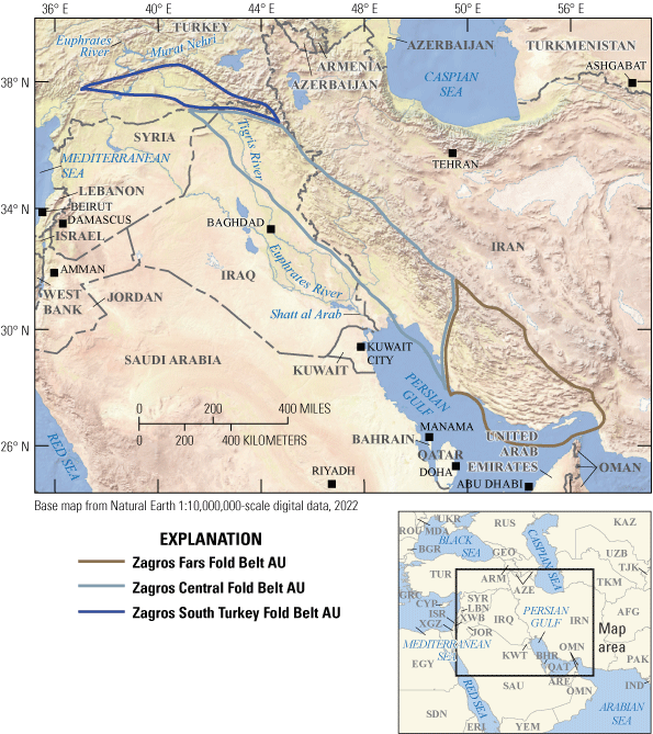
Map showing three conventional assessment units (AUs) in the Zagros Fold Belt of Iran, Iraq, Syria, and Turkey.
Total Petroleum System and Assessment Units
The USGS defined a Paleozoic–Cenozoic Composite Total Petroleum System (TPS) encompassing petroleum generated from several source rocks deposited on the northeastern margin of Gondwana that were subsequently buried by Zagros thrust sheets and as much as 5 kilometers of foreland basin sediments. Source rocks that may have provided oil and gas to Zagros structures include shales of the Silurian Gahkum Formation and organic-rich marls of the Sargelu and Tuwaiq Mountain Formations, Naokelekan Formation, Hanifa Formations, Kazhdumi Formation, Derdere Formation, Karabogaz Formation, and Paleogene Pabdeh Formation (Beydoun and others, 1992; Opera and others, 2013; Mashhadi and Rabbani, 2015; Baniasad and others, 2017). Organic-rich shales of the Kazhdumi Formation are source rocks in the Zagros Fold Belt (Ala, 1982; Beydoun and others, 1992; Alizadeh and others, 2012; Sfidari and others, 2016; Alipour, 2022), but oil and gas generated from other source rocks are included in the geologic models in this study. Assessment units (AUs) defined within the composite TPS are the Zagros Fars Fold Belt AU, Zagros Central Fold Belt AU, and Zagros South Turkey Fold Belt AU.
The geologic model for the Zagros Fars Fold Belt AU is for oil generated from Jurassic and Cretaceous intrashelf basinal source rocks to have migrated into carbonate platform-margin, dolomite, reef, and karst reservoirs; gas sourced from organic-rich shales of the Gahkum Formation migrated into Mesozoic fractured carbonate reservoirs within northwest–southeast-trending contractional structures and Hormuz salt structures (Bordenave, 2003).
The geologic model for the Zagros Central Fold Belt AU is for oil and gas generated from Silurian, Jurassic, Cretaceous, and Eocene source rocks to have migrated into northwest–southeast-trending contractional structures related to the closure of the neo-Tethys Ocean beginning in the Late Cretaceous. The progressive formation of the southwest-directed thrusts created a foredeep in front of the growing thrust belt, and the related sediment accumulation and thrust loading served to thermally mature source rocks across the northeastern margin. Geochemical analyses show that the major oil source rock in this AU is the Kazhdumi Formation. Oil and gas migrated into a spectrum of carbonate reservoirs, but most reservoirs are fractured carbonates of the Asmari Formation, sealed by evaporites of the overlying Gachsaran Formation.
The geologic model for the Zagros South Turkey Fold Belt AU is for oil generated from shales of the Kazhdumi Formation and possibly from shales of the Derdere and Karabogaz Formations—and gas from shales of the Gahkum Formation—to have migrated into carbonate platform-margin, reef, and karst reservoirs within Zagros contractional structures. Reservoirs also include minor Silurian and Devonian fluvial-deltaic to shelf sandstones.
Renewed movement of thrusts related to the opening of the Red Sea and the Gulf of Aden modified the northwest–southeast-trending contractional structures and led to possible loss of oil and gas throughout the fold belt due to fracturing of carbonate rocks and evaporite seals (Ziegler, 2001).
Each of the AUs was assessed for undiscovered conventional oil and gas resources. The assessment input data for three conventional AUs are summarized in table 1 and in Schenk (2025).
Table 1.
Key input data for three conventional assessment units in the Zagros Fold Belt Province of Iran, Iraq, Syria, and Turkey.[Gray shading indicates not applicable. AU, assessment unit; MMBO, million barrels of oil; BCFG, billion cubic feet of gas]
Undiscovered Resources Summary
The USGS quantitatively assessed undiscovered conventional oil and gas resources in three AUs in the Zagros Fold Belt Province (table 2). The estimated mean resources are 3,316 million barrels of oil (MMBO), or 3.3 billion barrels of oil, with an F95–F5 range from 1,667 to 5,638 MMBO; 80,258 billion cubic feet of gas (BCFG), or 80.3 trillion cubic feet of gas, with an F95–F5 range from 34,977 to 147,998 BCFG; and 1,889 million barrels of natural gas liquids (MMBNGL), or 1.9 billion barrels, with an F95–F5 range from 827 to 3,470 MMBNGL.
Table 2.
Results for three conventional assessment units in the Zagros Fold Belt Province of Iran, Iraq, Syria, and Turkey.[Results shown are fully risked estimates. F95 represents a 95-percent chance of at least the amount tabulated; other fractiles are defined similarly. Gray shading indicates not applicable. MMBO, million barrels of oil; BCFG, billion cubic feet of gas; NGL, natural gas liquids; MMBNGL, million barrels of natural gas liquids]
For More Information
Assessment results are also available at the USGS Energy Resources Program website, https://www.usgs.gov/programs/energy-resources-program.
References Cited
Abdulnaby, W., Motaghi, K., Shabanian, E., Mahdi, H., Al-Shukri, H., and Gök, R., 2020, Crustal structure of the Mesopotamian plain, east of Iraq: Tectonics, v. 39, no. 11, article e2020TC006225, accessed October 18, 2024, at https://doi.org/10.1029/2020TC006225.
Ala, M.A., 1982, Chronology of trap formation and migration of hydrocarbons in Zagros sector of southwest Iran: AAPG Bulletin, v. 66, no. 10, p. 1535–1541, accessed October 18, 2024, at https://doi.org/10.1306/03B5A980-16D1-11D7-8645000102C1865D.
Al-Husseini, M., 2000, Origin of the Arabian plate structures—Amar collision and Najd rift: GeoArabia, v. 5, no. 4, p. 527–542, accessed October 18, 2024, at https://doi.org/10.2113/geoarabia0504527.
Alipour, M., 2022, Organic facies and paleo-depositional environments of the Aptian–Albian Kazhdumi source rock in the Zagros Basin of Iran: Marine and Petroleum Geology, v. 145, article 105877, 11 p., accessed October 18, 2024, at https://doi.org/10.1016/j.marpetgeo.2022.105887.
Alizadeh, B., Sarafdokht, H., Rajabi, M., Opera, A., and Janbaz, M., 2012, Organic geochemistry and petrography of Kazhdumi (Albian–Cenomanian) and Pabdeh (Paleogene) potential source rocks in southern part of the Dezful embayment, Iran: Organic Geochemistry, v. 49, p. 36–46, accessed October 18, 2024, at https://doi.org/10.1016/j.orggeochem.2012.05.004.
Baniasad, A., Rabbani, A.R., Moallemi, S.A., Soleimany, B., and Rashidi, M., 2017, Petroleum system analysis of the northwestern part of the Persian Gulf, Iranian sector: Organic Geochemistry, v. 107, p. 69–85, accessed October 18, 2024, at https://doi.org/10.1016/j.orggeochem.2017.03.005.
Beydoun, Z.R., Clarke, M.W.H., and Stoneley, R., 1992, Petroleum in the Zagros Basin—A late Tertiary foreland basin overprinted onto the outer edge of a vast hydrocarbon-rich Paleozoic-Mesozoic passive-margin shelf, in Macqueen, R.W., and Leckie, D.A., eds., Foreland basins and fold belts: AAPG Memoir 55, p. 309–339, accessed October 18, 2024, at https://doi.org/10.1306/M55563C12.
Bordenave, M.L., 2003, Gas prospective areas in the Zagros domain of Iran and in the Gulf Iranian waters: AAPG Search and Discovery, article 10040a, 10 p., accessed October 18, 2024, at https://www.searchanddiscovery.com/pdfz/documents/bordenave02/images/bordenave02.pdf.html.
Carminati, E., Aldega, L., Bigi, S., Minelli, G., and Shaban, A., 2016, Not so simple “simply folded Zagros”—The role of pre-collisional extensional faulting, salt tectonics and multi-stage thrusting in the Sarvestan transfer zone (Fars, Iran): Tectonophysics, v. 671, p. 235–248, accessed October 18, 2024, at https://doi.org/10.1016/j.tecto.2016.01.033.
Carruba, S., Perotti, C.R., Buonaguro, R., Calabrò, R., and Carpi, R., 2006, Structural pattern of the Zagros fold-and-thrust belt in the Dezful embayment (SW Iran), in Mazzoli, S., and Butler, R.W.H., eds., Styles of continental contraction: Geological Society of America Special Paper 414, p. 11–32, accessed October 18, 2024, at https://doi.org/10.1130/2006.2414(02).
Grosjean, E., Love, G.D., Stalvies, C., Fike, D.A., and Summons, R.E., 2009, Origin of petroleum in the Neoproterozoic–Cambrian South Oman Salt Basin: Organic Geochemistry, v. 40, no. 1, p. 87–110, accessed October 18, 2024, at https://doi.org/10.1016/j.orggeochem.2008.09.011.
Homke, S., Vergés, J., Serra-Kiel, J., Bernaola, G., Sharp, I., Garcés, M., Montero-Verdú, I., Karpuz, R., and Goodarzi, M.H., 2009, Late Cretaceous–Paleocene formation of the proto-Zagros foreland basin, Lurestan Province, SW Iran: Geological Society of America Bulletin, v. 121, nos. 7–8, p. 963–978, accessed October 18, 2024, at https://doi.org/10.1130/B26035.1.
Konert, G., Afifi, A.M., Al-Hajri, S.A., and Droste, H.J., 2001, Paleozoic stratigraphy and hydrocarbon habitat of the Arabian plate: GeoArabia, v. 6, no. 3, p. 407–442, accessed October 18, 2024, at https://doi.org/10.2113/geoarabia0603407.
Koshnaw, R.I., Horton, B.K., Stockli, D.F., Barber, D.E., Tamar-Agha, M.Y., and Kendall, J.J., 2017, Neogene shortening and exhumation of the Zagros fold-thrust belt and foreland basin in the Kurdistan region of northern Iraq: Tectonophysics, v. 694, p. 332–355, accessed October 18, 2024, at https://doi.org/10.1016/j.tecto.2016.11.016.
Mashhadi, Z.S., and Rabbani, A.R., 2015, Organic geochemistry of crude oils and Cretaceous source rocks in the Iranian sector of the Persian Gulf—An oil-oil and oil-source rock correlation study: International Journal of Coal Geology, v. 146, p. 118–144, accessed October 18, 2024, at https://doi.org/10.1016/j.coal.2015.05.003.
Mouthereau, F., Lacombe, O., and Vergés, J., 2012, Building the Zagros collisional orogen—Timing, strain distribution and the dynamics of Arabia/Eurasia plate convergence: Tectonophysics, v. 532–535, p. 27–60, accessed October 18, 2024, at https://doi.org/10.1016/j.tecto.2012.01.022.
Opera, A., Alizadeh, B., Sarafdokht, H., Janbaz, M., Fouladvand, R., and Heidarifard, M.H., 2013, Burial history reconstruction and thermal maturity modeling for the Middle Cretaceous–Early Miocene petroleum system, southern Dezful embayment, SW Iran: International Journal of Coal Geology, v. 120, p. 1–14, accessed October 18, 2024, at https://doi.org/10.1016/J.COAL.2013.08.008.
Orang, K., Motamedi, H., Azadikhah, A., and Royatvand, M., 2018, Structural framework and tectono-stratigraphic evolution of the eastern Persian Gulf, offshore Iran: Marine and Petroleum Geology, v. 91, p. 89–107, accessed October 18, 2024, at https://doi.org/10.1016/j.marpetgeo.2017.12.014.
Pirouz, M., Simpson, G., Bahroudi, A., and Azhdari, A., 2011, Neogene sediments and modern depositional environments of the Zagros foreland basin system: Geological Magazine, v. 148, nos. 5–6, p. 838–853, accessed October 18, 2024, at https://doi.org/10.1017/S0016756811000392.
Ruban, D.A., Al-Husseini, M.I., and Iwasaki, Y., 2007, Review of Middle East Paleozoic plate tectonics: GeoArabia, v. 12, no. 3, p. 35–56, accessed October 18, 2024, at https://doi.org/10.2113/geoarabia120335.
Saura, E., Garcia-Castellanos, D., Casciello, E., Parravano, V., Urruela, A., and Vergés, J., 2015, Modeling the flexural evolution of the Amiran and Mesopotamian foreland basins of NW Zagros (Iran-Iraq): Tectonics, v. 34, no. 3, p. 377–395, accessed October 18, 2024, at https://doi.org/10.1002/2014TC003660.
Schenk, C.J., 2025, USGS National and Global Oil and Gas Assessment Project—Zagros Fold Belt of Iran and Turkey—Assessment unit boundaries, input data tables, and fact sheet data tables: U.S. Geological Survey data release, https://doi.org/10.5066/P133QODA.
Sepehr, M., and Cosgrove, J.W., 2004, Structural framework of the Zagros fold-thrust belt, Iran: Marine and Petroleum Geology, v. 21, no. 7, p. 829–843, accessed October 18, 2024, at https://doi.org/10.1016/j.marpetgeo.2003.07.006.
Sfidari, E., Zamanzadeh, S.M., Dashti, A., Opera, A., and Tavakkol, M.H., 2016, Comprehensive source rock evaluation of the Kazhdumi Formation, in the Iranian Zagros Foldbelt and adjacent offshore: Marine and Petroleum Geology, v. 71, p. 26–40, accessed October 18, 2024, at https://doi.org/10.1016/j.marpetgeo.2015.12.011.
Ziegler, M.A., 2001, Late Permian to Holocene paleofacies evolution of the Arabian plate and its hydrocarbon occurrences: GeoArabia, v. 6, no. 3, p. 445–504, accessed October 18, 2024, at https://doi.org/10.2113/geoarabia0603445.
Disclaimers
Any use of trade, firm, or product names is for descriptive purposes only and does not imply endorsement by the U.S. Government.
Although this information product, for the most part, is in the public domain, it also may contain copyrighted materials as noted in the text. Permission to reproduce copyrighted items must be secured from the copyright owner.
Suggested Citation
Schenk, C.J., Mercier, T.J., Le, P.A., Cicero, A.D., Drake, R.M., II, Gelman, S.E., Hearon, J.S., Johnson, B.G., Lagesse, J.H., Leathers-Miller, H.M., and Timm, K.K., 2025, Assessment of undiscovered conventional oil and gas resources of the Zagros Fold Belt of Iran, Iraq, Syria, and Turkey, 2023: U.S. Geological Survey Fact Sheet 2024–3048, 4 p., https://doi.org/10.3133/fs20243048.
ISSN: 2327-6932 (online)
Study Area
| Publication type | Report |
|---|---|
| Publication Subtype | USGS Numbered Series |
| Title | Assessment of undiscovered conventional oil and gas resources of the Zagros Fold Belt of Iran, Iraq, Syria, and Turkey, 2023 |
| Series title | Fact Sheet |
| Series number | 2024-3048 |
| DOI | 10.3133/fs20243048 |
| Publication Date | February 12, 2025 |
| Year Published | 2025 |
| Language | English |
| Publisher | U.S. Geological Survey |
| Publisher location | Reston VA |
| Contributing office(s) | Central Energy Resources Science Center |
| Description | Report: 4 p.; Data Release |
| Country | Iran, Iraq, Syria,Turkey |
| Other Geospatial | Zagros Fold Belt |
| Online Only (Y/N) | Y |