

Lithium Resource in the Smackover Formation Brines of Southern Arkansas
Links
- Document: Report (1.79 MB pdf) , HTML , XML
- Related Work: Evaluation of the lithium resource in the Smackover Formation brines of southern Arkansas using machine learning
- Data Release: USGS Data Release - Lithium observations, machine-learning predictions, and mass estimates from the Smackover Formation brines in southern Arkansas
- NGMDB Index Page: National Geologic Map Database Index Page (html)
- Download citation as: RIS | Dublin Core
Acknowledgments
We appreciate the cooperation of the private companies and well operators that provided access to wells for brine sampling. Colleague reviews from Seth Haines and Kenneth Belitz (USGS) improved this fact sheet and were greatly appreciated.
Abstract
Lithium-rich brine deposits occur throughout the United States, including in the Smackover Formation. The concentration of lithium in Smackover Formation brines was predicted across southern Arkansas by using a machine-learning model that incorporated lithium concentration data and geologic information. Between 5.1 and 19.0 million metric tons of lithium are calculated to be present in the brines of the Smackover Formation in southern Arkansas. The range in possible total lithium reflects the uncertainty in machine-learning predictions of lithium concentrations and the range of Smackover Formation porosity. This estimate quantifies the in-place lithium resource and does not consider the technological and economic feasibility of extracting the lithium from the brines.
Why is Lithium Important?
Lithium is the lightest of all metals and is listed as a critical element by the U.S. Geological Survey (USGS) because of its importance in renewable energy. Lithium is also used widely in ceramics and glassmaking, along with other manufacturing industries. Lithium demand is expected to increase as the world transitions from hydrocarbon combustion engines to electric vehicles, which currently use lithium in the rechargeable batteries (Bradley and others, 2017).
Where Is Lithium Found?
Lithium is found in some igneous rocks and clay deposits throughout the world and is dissolved in subsurface brines, which are characterized as water with high salinity (Bradley and others, 2017). Lithium-rich brine deposits occur throughout the United States, including in the Smackover Formation. The Smackover Formation is a geologic unit of Jurassic age that extends across the Gulf Coast region from Texas to Florida (fig. 1). The Smackover Formation is approximately 2,000 feet deep at its northern extent to more than 22,000 feet deep further south (American Association of Petroleum Geologists, 2023). Brines, including dissolved lithium, occur within voids—or pore space—between mineral grains of the Smackover Formation (fig. 2). Generally, the upper part of the Smackover Formation has higher porosity than the lower part and is referred to informally as the Reynolds oolite (Akin and Graves, 1969).
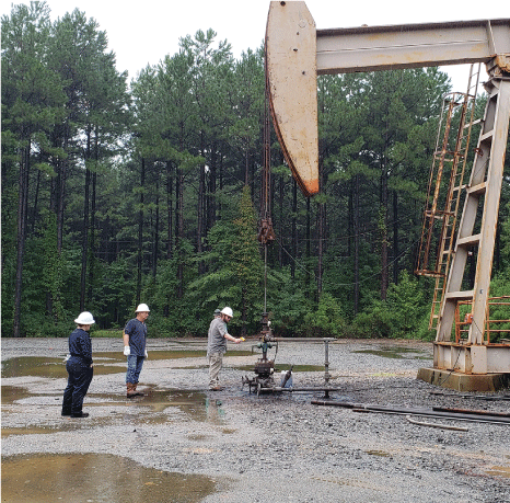
Scientists from the USGS and the Arkansas Department of Energy and Environment's Office of the State Geologist visit an oil well with an operator to collect brine samples. Photograph by Katherine Knierim, USGS.
How High Are Lithium Concentrations in the Smackover Formation?
Based on historical (1965 through 2018) and newly collected (2022) brine geochemical data, lithium concentrations range from approximately 1 to 477 milligrams per liter (mg/L) in the Smackover Formation across the Gulf Coast (fig. 1) (Blondes and others, 2023; Knierim and others, 2024a, b). Many wells with brine lithium concentrations greater than 100 mg/L are in southwestern Arkansas, especially in Lafayette, Columbia, and Union Counties. Lithium concentrations greater than 500 mg/L were observed in brine samples collected in the 1960s in southern Arkansas (Blondes and others, 2023); however, these concentrations could not be verified from the source information, and similarly high lithium concentrations were not measured during more recent sampling near the historical locations (Knierim and others, 2024a, b).
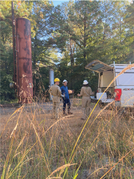
USGS scientists Andrew Masterson, Colin Doolan, and Katherine Knierim have a tailgate safety meeting prior to sampling brines at a well site. Photograph by Amanda Herzberg, USGS.
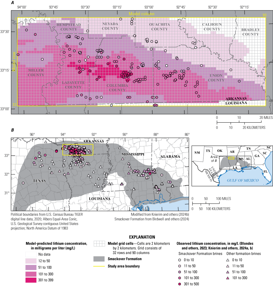
A, B, Observed lithium concentrations in brine samples from the Smackover Formation and model-predicted lithium concentrations throughout the Smackover Formation in southern Arkansas and B, observed lithium concentrations in brine samples from the Smackover Formation and other geologic units across the Gulf Coast region.
How Do You Measure Lithium in Brine Samples?
Brine is produced as a waste product during petroleum extraction from oil and gas wells. Brine samples are collected from oil, gas, or brine wells, filtered, and analyzed for dissolved lithium and many other constituents in laboratories. In 2022, the USGS, in cooperation with the Arkansas Department of Energy and Environment, Office of the State Geologist, collected brine samples in southern Arkansas for analysis at the USGS Brine Research Instrumentation and Experimental Laboratory (BRInE) in Reston, Virginia (https://www.usgs.gov/labs/brine-research-instrumentation-and-experimental-laboratory) (Knierim and others, 2024a, b). The concentration of lithium is measured based on its dissolved ionic form rather than as a solid.
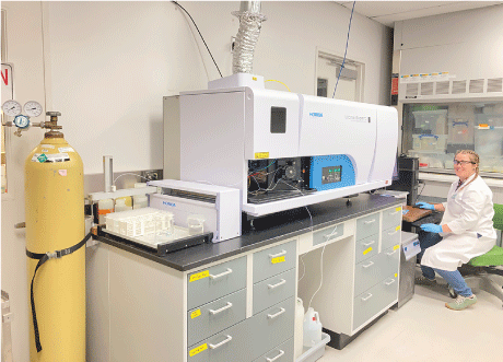
USGS scientist Amanda Herzberg analyzes brine samples on the Inductively Coupled Plasma Optical Emission Spectrometer in the USGS BRInE laboratory. Photograph by Amanda Herzberg, USGS.
How Much Lithium Is in the Smackover Formation in Southern Arkansas?
The amount of lithium in the subsurface depends on both the volume of brine in the Smackover Formation and the concentration of lithium within that brine. The volume of brine in the Smackover Formation depends on the volume of rock and its porosity (fig. 2). The Reynolds oolite portion of the Smackover Formation varies from 0 feet (that is, pinching out) to more than 400 feet thick across southern Arkansas (fig. 2) (Akin and Graves, 1969). Porosity within the Reynolds oolite ranges from 0.5 to 31 percent, with average values between 10 and 31 percent in the region's oil reservoirs (Nehring Associates, 2019; Li, 2023). Therefore, the volume of brine in the Smackover Formation of southern Arkansas was calculated by using porosity values of 10, 20, and 30 percent to illustrate the possible range in the brine volume (table 1) (Knierim and others, 2024b).
The concentration of lithium in brines was predicted across southern Arkansas by using a machine-learning model that incorporated lithium concentration data and geologic information (fig. 1) (Knierim and others, 2024b). Machine learning can identify complex patterns in datasets (Kuhn and Johnson, 2016) and use the information to predict lithium concentrations in areas where samples are unavailable (fig. 1) (Knierim and others, 2024b). The variations in the machine-learning models were used to create “low,” “median,” and “high” lithium concentration prediction maps, providing a range of values that quantify uncertainty in the predictions of lithium concentration (table 1) (Knierim and others, 2024b). Lithium concentrations were predicted at a model resolution of about 1.5 square miles, making them unsuitable for quantifying lithium at specific locations. However, the machine-learning predictions provide a way to estimate how lithium concentrations vary spatially across a region (fig. 1).
Between 5.1 and 19.0 million metric tons of lithium are calculated to be present in the brines of the Smackover Formation in southern Arkansas (table 1) (Knierim and others, 2024b). The range in possible total lithium reflects the uncertainty in machine-learning predictions of lithium concentrations and the range of Smackover Formation porosity. This estimate quantifies the in-place lithium resource and does not consider the technological and economic feasibility of extracting the lithium from the brines. Additionally, based on the predicted concentrations of lithium and brine production data, in 2022, approximately 5,000 metric tons of dissolved lithium was brought to the surface in brines as part of the existing waste stream associated with the oil, gas, and brine industries in southern Arkansas (Knierim and others, 2024b).
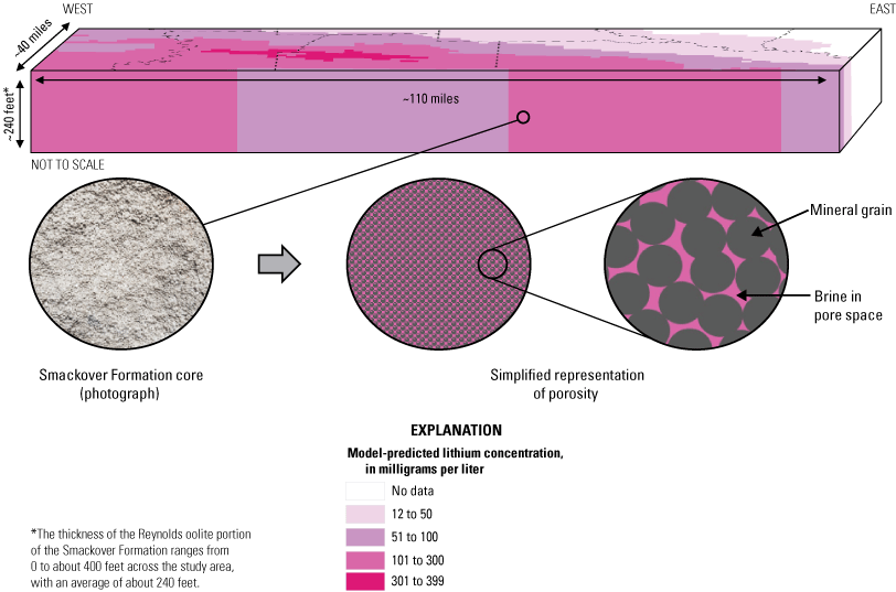
Idealized representation showing a “box model” of the Reynolds oolite portion of the Smackover Formation in southern Arkansas. The box model illustrates how the calculated amount of lithium in the subsurface (table 1) depends on both the volume of brine contained within the pore space of the Smackover Formation and the spatial variation in predicted lithium concentrations from the machine-learning model.
Table 1.
Calculated amount of lithium in brines of the Smackover Formation, based on porosity ranging from 10 to 30 percent and low, median, and high machine-learning model predictions of lithium concentrations (modified from Knierim and others, 2024b).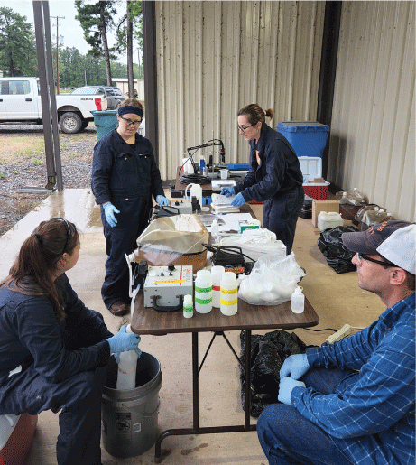
USGS scientists Bonnie McDevitt, Amanda Herzberg, Madalyn Blondes, and Colin Doolan process brine samples at a mobile field station. Photograph by Katherine Knierim, USGS.
References Cited
American Association of Petroleum Geologists, 2023, Reservoirs and petroleum systems of the Gulf Coast, accessed October 16, 2023, at https://www.datapages.com/gis-map-publishing-program/gis-open-files/geographic/reservoirs-and-petroleum-systems-of-the-gulf-coast.
Birdwell, J.E., Whidden, K.J., Paxton, S.T., Kinney, S.A., Gardner, R.D., Pitman, J.K., French, K.L., Mercier, T.J., Woodall, C.A., Leathers-Miller, H.M., and Schenk, C.J., 2024, Assessment of undiscovered, technically recoverable conventional oil and gas resources in the Upper Jurassic Smackover Formation, U.S. Gulf Coast, 2022: U.S. Geological Survey Fact Sheet 2023–3046, accessed October 3, 2024, at https://doi.org/10.3133/fs20233046.
Blondes, M.S., Knierim, K.J., Croke, M.R., Freeman, P.A., Doolan, C., Herzberg, A.S., and Shelton, J.L., 2023, U.S. Geological Survey National Produced Waters Geochemical Database (ver. 3.0, December 2023): U.S. Geological Survey data release, accessed December 20, 2023, at https://doi.org/10.5066/P9DSRCZJ.
Bradley, D.C., Stillings, L.L., Jaskula, B.W., Munk, L., and McCauley, A.D., 2017, Lithium, chap. K of Schulz, K.J., DeYoung, J.H., Jr., Seal, R.R., II, and Bradley, D.C., eds., Critical mineral resources of the United States—Economic and environmental geology and prospects for future supply: U.S. Geological Survey Professional Paper 1802–K, p. 21, accessed April 27, 2021, at https://pubs.er.usgs.gov/publication/pp1802.
Knierim, K.J., Blondes, M.S., Freeman, P.A., Masterson, A.L., McDevitt, B., Herzberg, A.S., Doolan, C., Chenault, J.M., Jubb, A., and Croke, M.R., 2024a, Lithium observations, machine-learning predictions, and mass estimates from the Smackover Formation brines in southern Arkansas: U.S. Geological Survey data release, https://doi.org/10.5066/P9QPRYZN.
Knierim, K.J., Blondes, M.S., Masterson, A., Freeman, P., McDevitt, B., Herzberg, A., Li, P., Mills, C., Doolan, C., Jubb, A.M., Ausbrooks, S.M., and Chenault, J., 2024b, Evaluation of the lithium resource in the Smackover Formation brines of southern Arkansas using machine learning: Science Advances, v. 10, no. 39, article eadp8149, accessed October 1, 2024, at https://doi.org/10.1126/sciadv.adp8149.
Li, P., 2023, Core plug analysis of the upper Smackover Formation in Lafayette County, southwestern Arkansas: Arkansas Department of Energy and Environment, Office of the State Geologist Open-File Report 2023–02, 14 p., accessed August 20, 2023, at https://www.geology.arkansas.gov/publication/open_file_reports/OFR-2023-02-open-file-report.html.
Disclaimers
Any use of trade, firm, or product names is for descriptive purposes only and does not imply endorsement by the U.S. Government.
Although this information product, for the most part, is in the public domain, it also may contain copyrighted materials as noted in the text. Permission to reproduce copyrighted items must be secured from the copyright owner.
Suggested Citation
Knierim, K.J., Masterson, A.L., Freeman, P.A., McDevitt, B., Herzberg, A.H., Li, P., Mills, C., Doolan, C., Jubb, A.M., Ausbrooks, S.M., and Chenault, J., 2024, Lithium resource in the Smackover Formation brines of southern Arkansas: U.S. Geological Survey Fact Sheet 2024–3052, 4 p., https://doi.org/10.3133/fs20243052.
ISSN: 2327-6932 (online)
ISSN: 2327-6916 (print)
Study Area
| Publication type | Report |
|---|---|
| Publication Subtype | USGS Numbered Series |
| Title | Lithium resource in the Smackover Formation brines of Southern Arkansas |
| Series title | Fact Sheet |
| Series number | 2024-3052 |
| DOI | 10.3133/fs20243052 |
| Publication Date | December 18, 2024 |
| Year Published | 2024 |
| Language | English |
| Publisher | U.S. Geological Survey |
| Publisher location | Reston, VA |
| Contributing office(s) | Lower Mississippi-Gulf Water Science Center, Geology, Energy & Minerals Science Center |
| Description | Report: 4 p.; Data Release |
| Country | United States |
| State | Arkansas |
| Online Only (Y/N) | N |