

The 3D Elevation Program—Supporting the Kansas Economy
Links
- Document: Report (432 KB pdf) , HTML , XML
- NGMDB Index Page: National Geologic Map Database Index Page (html)
- Download citation as: RIS | Dublin Core
Introduction
High-resolution elevation data for Kansas inform decision making to improve the State’s economy. Existing elevation data coverage is used to support State water planning initiatives, facilitate infrastructure management, and improve resilience to natural disasters. The expanding availability of current and more accurate elevation data helps better support natural resources conservation, agriculture and precision farming, flood risk management, water supply planning, infrastructure and construction management, and geologic resource assessment and hazard mitigation. Critical applications that meet the State’s management needs depend on light detection and ranging (lidar) data that provide a highly detailed three-dimensional (3D) model of the Earth’s surface and aboveground features.
The 3D Elevation Program (3DEP; refer to sidebar) is managed by the U.S. Geological Survey (USGS) in partnership with Federal, State, Tribal, U.S. territorial, and local agencies to acquire consistent lidar coverage at quality level 2 or better (table 1) to meet the many needs of the Nation and Kansas. The status of available and in-progress 3DEP baseline lidar data in Kansas is shown in figure 1. 3DEP baseline lidar data include quality level 2 or better, 1-meter or better digital elevation models, and lidar point clouds, and must meet the Lidar Base Specification version 1.2 (https://www.usgs.gov/3dep/lidarspec) or newer requirements. The National Enhanced Elevation Assessment (Dewberry, 2012) identified user requirements and conservatively estimated that availability of lidar data would result in at least $14.41 million in new benefits annually to the State. The top nine Kansas business uses for 3D elevation data, which are based on the estimated annual conservative benefits of 3DEP, are shown in table 2.
Table 1.
Data quality levels, pulse spacing, and pulse density. Quality level 2 or better lidar data meet 3DEP requirements.[Specifications for quality level 0 (QL0) are from Heidemann (2012, p. 3 and table 1); for quality levels 1 and 2, specifications are from Sugarbaker and others (2014, table 1). In the quality level column, QL0 represents the highest level of quality. RMSEz, root mean square error in the elevation (z) dimension; cm, centimeter; m, meter; pls/m2, first return pulses per square meter; ≤, less than or equal to; ≥, greater than or equal to]
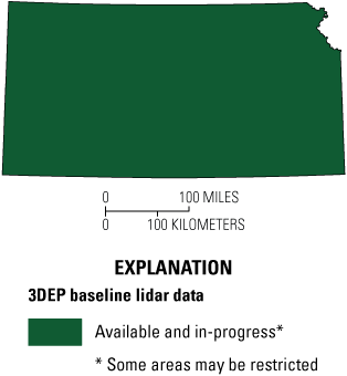
Map of Kansas showing status of 3D Elevation Program (3DEP) baseline lidar data as of July 2024. Visit https://usgs.gov/NationalMap/LidarExplorer to find and download currently available data.
Table 2.
Conservative benefits estimates for the top nine Kansas business uses of the proposed 3DEP data identified in the National Enhanced Elevation Assessment (Dewberry, 2012).Status of 3DEP in Kansas
The State of Kansas has statewide lidar coverage consisting mostly of quality level 2 (QL2) lidar collected between 2010 and 2018. Quality level 1 (QL1) projects that are existing or underway in 2024 will provide QL1 coverage for approximately one-third of the State. Future acquisitions will be needed as older QL2 data age beyond the eight-year 3DEP guideline, and as the need for QL1 data becomes more widespread for change detection and in areas of low relief that are predominant in much of the State. Kansas participated in the 3D Nation study (Dewberry Engineers, Inc., 2022) to help define needs for the next generation of lidar data for the State and the Nation.
Water Supply and Quality
The Kansas Water Vision (Kansas Water Office, 2015) and the Kansas Water Plan (Kansas Water Office, 2022) are in place to evaluate water supplies and future water-use demands. Lidar data play a key part in the work to support these plans, including conducting sedimentation analyses upstream of water-supply reservoirs, evaluating geomorphic changes, identifying actively eroding streambanks, calculating lost sediment volumes and impacts to downstream public water-supply reservoirs, analyzing erosion from agriculture sites, and identifying sources of nutrients and upstream erosion that cause harmful algal blooms.
Flood Risk Management
High-resolution elevation data are the basis for flood mapping by the Kansas Department of Agriculture and the Kansas Biological Survey & Center for Ecological Research. Accurate mapping of flood plains provides citizens information on the dangers of development in these high-risk areas, and to subsequently reduce financial costs and loss of human life due to flooding. Higher quality elevation data such as quality level 1 can provide significant benefits for flood inundation modeling.
Geologic Resource Assessment and Hazard Mitigation
Geologic mapping, including the assessment of mineral deposits and geologic hazards, can be performed more efficiently and accurately using lidar data. Geologic maps depict bedrock—the solid rock at the Earth’s surface or directly beneath vegetation, soil, and thin deposits of unconsolidated material—and thick layers of sediment. These maps are essential for basic geologic research, evaluating natural resources, and land-use planning. Lidar data also are essential for geoarchaeology investigations of sediments, soils, and landforms to help identify areas of potential cultural deposits and assess prehistoric environments.
Natural Resources Conservation
Conservation of natural resources is assisted by lidar data for a variety of applications including soil conservation techniques, stream bank stabilization, point-source and non-point-source pollution modeling, and identification of wetlands for wildlife habitat and recreational purposes. A Topographic Wetland Identification Process (Kastens and others, 2016) was developed by the Kansas Biological Survey & Center for Ecological Research in collaboration with the Kansas Water Office to develop a standardized methodology and tool for wetland assessment and prioritization (Kansas Water Office, 2019) that can be used for wetland protection and restoration efforts by all agencies, watershed planners, and stakeholder groups in the State (fig. 2).
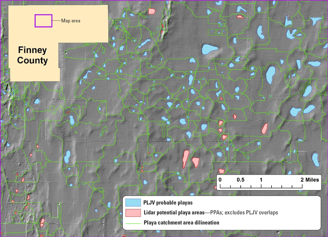
Map of an area in Finney County in western Kansas, where playa lakes were originally mapped (blue) using photointerpretation in the Playa Lakes Joint Venture (PLJV) database. Once lidar became available, additional playas were identified (in red) and playa catchment delineations were made (in green). Graphic courtesy of Kansas Biological Survey & Center for Ecological Research.
Infrastructure and Construction Management
State and regional agencies in Kansas use high-resolution elevation data for infrastructure and construction planning and management. Primary lidar uses include highway safety improvement, airspace protection near airports and air ambulance sites, emergency response planning, and bridge and road design, construction, and maintenance.
3D Elevation Program (3DEP)
The 3D Elevation Program is managed by the U.S. Geological Survey (USGS) on behalf of the community of Federal, State, Tribal, local, and other partners and users of elevation data. In response to growing needs for high-quality elevation data, the goal of 3DEP is to complete acquisition of nationwide light detection and ranging (lidar) data (interferometric synthetic aperture radar [IfSAR] data in Alaska) to provide the first-ever national baseline of consistent, high-resolution topographic elevation data—both bare-earth digital elevation models and 3D point clouds.
Benefits
-
• Economies of scale by acquiring data for larger areas.
-
• Predictable and flexible Federal investments that can reduce costs and allow better planning.
-
• Consistent national coverage that provides data for applications that span project, jurisdictional, and watershed boundaries.
-
• Simplified data acquisition that provides contracts, project management, quality assurance, and published data specifications.
-
• National benefits of $690 million per year conservatively, with the potential to generate $13 billion per year in additional benefits through applications that span the economy (Dewberry, 2012).
High-Quality Data and Products
3DEP lidar data provide coverage with a minimum of two points per square meter and a vertical error not to exceed 10 centimeters, measured as root mean square error in the elevation (z) dimension (RMSEz) (table 1). 3DEP baseline lidar data products include all data points collected (point clouds) and bare-earth digital elevation models with a 1-meter or better resolution. The USGS integrates the elevation data into The National Map. Data are available free of charge and without use restrictions. To download 3DEP products visit https://apps.nationalmap.gov/downloader/.
Ways to Participate
Participation in 3DEP is open to Federal, State, Tribal, U.S. territorial, and local government partners, as well as private sector partners, and offers the option to acquire even higher quality data. Partners may contribute funds toward projects managed by the USGS, or they may receive cooperative funds to manage their own projects. An annual Data Collaboration Announcement is the mechanism used to establish partner agreements. Organizations and the private sector may contribute existing data that meet 3DEP requirements. For more information refer to the 3DEP website at https://www.usgs.gov/3DEP/collaborate/.
References Cited
Dewberry, 2012, National Enhanced Elevation Assessment final report (revised March 29, 2012): Fairfax, Va., Dewberry, 84 p. plus appendixes, accessed July 8, 2024, at https://www.dewberry.com/services/geospatial/national-enhanced-elevation-assessment.
Dewberry Engineers, Inc., 2022, 3D Nation Elevation Requirements and Benefits Study final report: Fairfax, Va., Dewberry Engineers, Inc., 171 p., accessed July 8, 2024, at https://iocm.noaa.gov/reports/3dnationstudy/3D_Nation_Study_Final_Report.pdf.
Heidemann, H.K., 2012, Lidar base specification (ver. 1.2, November 2014): U.S. Geological Survey Techniques and Methods, book 11, chap. B4, 67 p. with appendixes, accessed July 8, 2024, at https://doi.org/10.3133/tm11B4.
Kansas Water Office, 2015, A long-term vision for the future of water supply in Kansas: Kansas Water Office report, 132 p., accessed July 8, 2024, at https://www.kwo.ks.gov/home/showpublisheddocument/1180/638338156260670000.
Kansas Water Office, 2019, Kansas Wetland Program Plan 2019‒2023: Kansas Water Office report, 24 p., accessed July 8, 2024, at https://www.kwo.ks.gov/projects/wetland-program.
Kansas Water Office, 2022, The 2022 Kansas Water Plan: Kansas Water Office report, 221 p. plus 3 appendixes (40 p.), accessed June 24, 2024, at https://kansas-water-plan-ksdot.hub.arcgis.com/pages/kansas-water-plan.
Kastens, J.H., Baker, D.S., Peterson, D.L., and Huggins, D.G., 2016, Wetland Program Development Grant (WPDG) FFY 2013—Playa mapping and assessment: Kansas Biological Survey Report 186, 28 p., accessed June 24, 2024, at https://hub.kansasgis.org/documents/KU:kbs-report-186-playa-mapping-assessment-2016/.
Sugarbaker, L.J., Constance, E.W., Heidemann, H.K., Jason, A.L., Lukas, V., Saghy, D.L., and Stoker, J.M., 2014, The 3D Elevation Program initiative—A call for action: U.S. Geological Survey Circular 1399, 35 p., accessed July 8, 2024, at https://doi.org/10.3133/cir1399.
For Further Information:
Director, National Geospatial Program
U.S. Geological Survey, MS 511
12201 Sunrise Valley Drive
Reston, VA 20192
Email: [email protected]
USGS National Map Liaison:
Claire DeVaughan; Email: [email protected]
Disclaimers
Any use of trade, firm, or product names is for descriptive purposes only and does not imply endorsement by the U.S. Government.
Although this information product, for the most part, is in the public domain, it also may contain copyrighted materials as noted in the text. Permission to reproduce copyrighted items must be secured from the copyright owner.
Suggested Citation
DeVaughan, C., 2024, The 3D Elevation Program—Supporting the Kansas economy: U.S. Geological Survey Fact Sheet 2024–3053, 2 p., https://doi.org/10.3133/fs20243053.
ISSN: 2327-6932 (online)
Study Area
| Publication type | Report |
|---|---|
| Publication Subtype | USGS Numbered Series |
| Title | The 3D Elevation Program—Supporting the Kansas Economy |
| Series title | Fact Sheet |
| Series number | 2024-3053 |
| DOI | 10.3133/fs20243053 |
| Publication Date | December 19, 2024 |
| Year Published | 2024 |
| Language | English |
| Publisher | U.S. Geological Survey |
| Publisher location | Reston, VA |
| Contributing office(s) | National Geospatial Program |
| Description | 2 p. |
| Country | United States |
| State | Kansas |
| Online Only (Y/N) | Y |
| Additional Online Files (Y/N) | N |