

Water Resources Related to Breccia Pipe Uranium Mining in the Grand Canyon Region
Links
- More information: Publisher Index Page (via DOI)
- Documents:
- Related Works:
- USGS FS 2024–3003 - Balancing natural resource use and extraction of uranium and other elements in the Grand Canyon region
- USGS SIR 2010–5025 - Hydrological, geological, and biological site characterization of breccia pipe uranium deposits in northern Arizona
- Journal Article - Anthropogenic influence on groundwater geochemistry in Horn Creek watershed near the Orphan Mine in Grand Canyon National Park, Arizona, USA
- Journal Article - Utilizing anthropogenic compounds and geochemical tracers to identify preferential structurally controlled groundwater pathways influencing springs in Grand Canyon National Park, Arizona, USA
- Journal Article - Geochemistry and hydrology of perched groundwater springs—Assessing elevated uranium concentrations at Pigeon Spring relative to nearby Pigeon Mine, Arizona (USA)
- USGS SIR 2022–5037 - Conceptual models of groundwater flow in the Grand Canyon region, Arizona
- Journal Article - Rethinking groundwater flow on the South Rim of the Grand Canyon, USA—Characterizing recharge sources and flow paths with environmental tracers
- Journal Article - Assessing uranium and select trace elements associated with breccia pipe uranium deposits in the Colorado River and main tributaries in Grand Canyon, USA
- Journal Article - An assessment of uranium in groundwater in the Grand Canyon region
- Download citation as: RIS | Dublin Core
Introduction
In the arid Grand Canyon region in northwestern Arizona, water resources are limited to primarily the Colorado River and associated tributaries and to groundwater in the form of seeps and springs. Groundwater resources in the region supply water for human use and support diverse and rich ecosystems in the locations immediately surrounding the seeps and springs. Throughout the region, uranium resources occur and may interact with water resources in both mined and unmined uranium deposits. There is a need to better understand groundwater in the region and the effects from uranium mining in order to better manage the limited water resources in the area. This Fact Sheet summarizes results from U.S. Geological Survey (USGS) studies that were conducted on this topic from 2012 to 2023.
Where Does Water Occur Near the Grand Canyon?
Surface water infiltrates the ground in higher elevation areas of the Grand Canyon region, such as the Kaibab Plateau and San Francisco Mountain (known locally as the “San Francisco Peaks”), where the amount of rainfall and snowmelt is greater (Knight and Huntoon, 2022). Water from these infiltration sources moves through the ground and combines to form an aquifer, which is composed of layers of rocks below ground where the cracks, crevices, and spaces between rock particles are full of water. There are two main aquifers in the Grand Canyon region. The shallower one is called the C-aquifer and is where water accumulates relatively close to the land surface in geologic units such as the Kaibab and Toroweap Formations and also below in the Coconino Sandstone. The deeper aquifer, located several hundred to thousands of feet below the C-aquifer, is called the R-aquifer and is where water accumulates below the Supai Group primarily in the Redwall and Muav Limestones (Knight and Huntoon, 2022). The Havasupai Tribe has utilized the groundwater from the R-aquifer as a primary water source for Supai for their entire existence (fig. 1).1
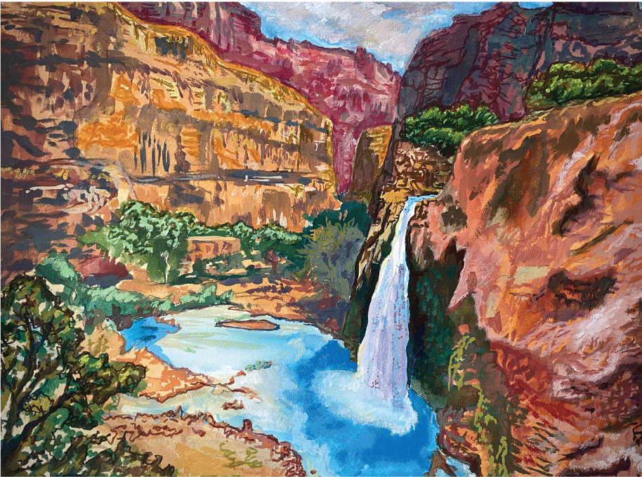
Illustration of Havasu Falls, which consists of R-aquifer groundwater from Havasu Springs, one of the largest springs in the Grand Canyon region.
How Long Does It Take for the Water To Move Through the Ground?
There is evidence of both fast and slow groundwater pathways in the Grand Canyon region (Solder and others, 2020; Beisner and others, 2023b). As water moves through the ground, openings in the rock such as fractures, joints, and faults can provide easy pathways for the water to move quickly (fig. 2), whereas other rock features such as tight mineral connections and fault damage can slow or prevent water flow. Water movement through rock units also can change over time because rocks shift and openings expand or fill in. Water may take several hundred to tens of thousands of years to infiltrate from rainfall and snowmelt on the land surface of high-elevation areas, such as San Francisco Mountain (“San Francisco Peaks”), and later emerge at springs along the South Rim of the Grand Canyon (Solder and others, 2020). In some cases, water can move from the C-aquifer to the R-aquifer in just years to decades in some limited areas with open features that allow fast water movement (Beisner and others, 2023b).
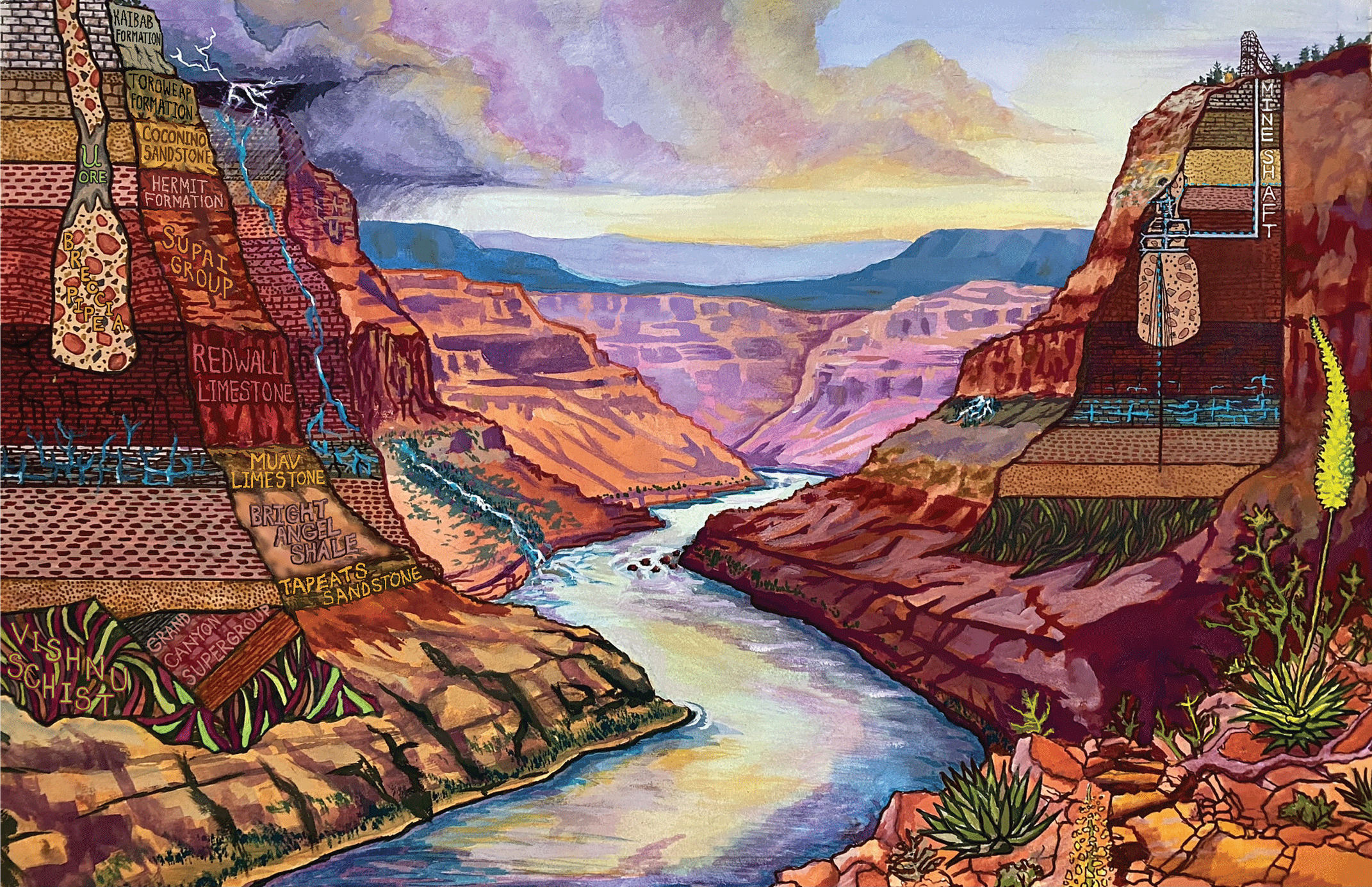
Generalized schematic view, not to scale, through the Grand Canyon with the Colorado River in the center, an unmined breccia pipe on the left side, and the Orphan Mine and associated breccia pipe on the right side. Dashed blue lines show a conceptual understanding of how water may interact with the Orphan Mine workings.
On the South Rim of the Grand Canyon, in Grand Canyon National Park, treated wastewater is released into the typically dry Bright Angel Wash along the Bright Angel Fault (Beisner and others, 2023b). Water added to the environment from human activities can move through the fast groundwater pathways. Chemical compounds associated with this wastewater (such as pharmaceuticals, nutrients, artificial sweeteners, and per- and polyfluoroalkyl substances) have been detected in groundwater samples collected in the Grand Canyon at a spring known locally as “Monument spring,” suggesting that water from the land surface moves fairly quickly (years) down through several thousand feet of rock at this location (Beisner and others, 2023b). However, this combination of wastewater chemical compounds has not been found at nearby springs in the Grand Canyon (Beisner and others, 2023b), and water chemistry at the other sites suggests older water that has been moving through the ground prior to the 1950s (Solder and others, 2020).
How Does the Water Change as It Moves Through the Ground?
Groundwater can sometimes contain elements that are not safe for humans and ecosystems. These elements may be in the water naturally or can be introduced from human activities. Breccia pipes are underground chimney-like features that can contain high concentrations of uranium, copper, arsenic, lead, and zinc. These elements are present in the breccia pipes naturally but may interact with groundwater related to mining activities (fig. 2). Breccia pipes were once underground pathways for fluids to flow but have mostly closed over time as uranium and other elements were deposited (Alpine, 2010). In the Grand Canyon region, uranium and other trace elements are present in high concentrations within the breccia pipes. The breccia pipes are rooted in the Redwall Limestone and may extend upward several thousand feet through the C-aquifer and the Kaibab and Toroweap Formations.
Conditions within breccia pipes and adjacent subsurface areas can affect the mobility and persistence of minerals below ground (Tillman and others, 2021). Several breccia pipes in the region have been mined to extract the valuable minerals, and the USGS has been conducting scientific investigations to understand changes that may have occurred to water resources as a result of these mining activities. Mining can open a pathway for water to migrate deeper into the ground, and more needs to be understood about the water interactions in these pathways during the mining life cycle. Fast groundwater pathways in the region and near mines are not well understood, so the focused studies were conducted to better understand water chemistry in the region, including at areas near mines.
Uranium concentrations measured in water resources of the Grand Canyon region are generally lower than the U.S. Environmental Protection Agency drinking water standard of 30 micrograms per liter (µg/L) (https://www.epa.gov/ground-water-and-drinking-water/national-primary-drinking-water-regulations), with few measured sites showing higher concentrations (Tillman and others, 2020, 2021). However, the highest concentration of uranium in the Grand Canyon region measured by the USGS is 293 µg/L at a spring in Horn Creek along the South Rim of the Grand Canyon (Beisner and others, 2023a) (fig. 3). Horn Creek is near the Orphan Mine, a former breccia pipe copper and uranium mine, which may have pathways for water migration through the mine. Pigeon Spring also has high measured uranium concentrations (50–92 µg/L) and is near a different breccia pipe uranium mine, the Pigeon Mine, north of the Grand Canyon (Tillman and others, 2021). However, a focused investigation suggested that the high uranium concentrations measured at Pigeon Spring are not related to the mine but originate from another location (Beisner and others, 2017).
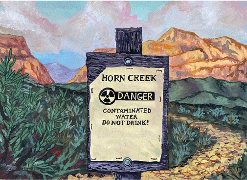
Illustration of sign at Horn Creek in the Grand Canyon.
Scientific investigations have increased knowledge of the limited water resources in the Grand Canyon region including groundwater residence time and amounts and sources of elements in the water. Studies are continuing to help provide a better understanding of groundwater movement and sources of uranium and other trace elements to groundwater in the Grand Canyon region of Arizona.
References Cited
Alpine, A.E., ed., 2010, Hydrological, geological, and biological site characterization of breccia pipe uranium deposits in northern Arizona: U.S. Geological Survey Scientific Investigations Report 2010–5025, 353 p., 1 pl., scale 1:375,000, accessed October 16, 2024, at https://pubs.usgs.gov/sir/2010/5025/.
Beisner, K.R., Davidson, C., and Tillman, F., 2023a, Anthropogenic influence on groundwater geochemistry in Horn Creek watershed near the Orphan Mine in Grand Canyon National Park, Arizona, USA: Geochemistry: Exploration, Environment, Analysis, v. 23, no. 3, accessed October 16, 2024, at https://doi.org/10.1144/geochem2023-007.
Beisner, K.R., Paretti, N.V., Jasmann, J.R., and Barber, L.B., 2023b, Utilizing anthropogenic compounds and geochemical tracers to identify preferential structurally controlled groundwater pathways influencing springs in Grand Canyon National Park, Arizona, USA: Journal of Hydrology: Regional Studies, v. 48, article 101461, accessed October 16, 2024, at https://doi.org/10.1016/j.ejrh.2023.101461.
Beisner, K.R., Paretti, N.V., Tillman, F.D., Naftz, D.L., Bills, D.J., Walton-Day, K., and Gallegos, T.J., 2017, Geochemistry and hydrology of perched groundwater springs—Assessing elevated uranium concentrations at Pigeon Spring relative to nearby Pigeon Mine, Arizona (USA): Hydrogeology Journal, v. 25, no. 2, p. 539–556, accessed October 16, 2024, at https://doi.org/10.1007/s10040-016-1494-8.
Knight, J.E., and Huntoon, P.W., 2022, Conceptual models of groundwater flow in the Grand Canyon region, Arizona: U.S. Geological Survey Scientific Investigations Report 2022–5037, 51 p., accessed October 16, 2024, at https://doi.org/10.3133/sir20225037.
Solder, J.E., Beisner, K.R., Anderson, J.R., and Bills, D.J., 2020, Rethinking groundwater flow on the South Rim of the Grand Canyon, USA—Characterizing recharge sources and flow paths with environmental tracers: Hydrogeology Journal, v. 28, no. 5, p. 1593–1613, accessed October 16, 2024, at https://doi.org/10.1007/s10040-020-02193-z.
Tillman, F.D., Anderson, J.R., Unema, J.A., and Chapin, T.P., 2020, Assessing uranium and select trace elements associated with breccia pipe uranium deposits in the Colorado River and main tributaries in Grand Canyon, USA: PLoS ONE, v. 15, no. 11, article e0241502, accessed October 16, 2024, at https://doi.org/10.1371/journal.pone.0241502.
Tillman, F.D., Beisner, K.R., Anderson, J.R., and Unema, J.A., 2021, An assessment of uranium in groundwater in the Grand Canyon region: Scientific Reports, v. 11, article 22157, accessed October 16, 2024, at https://doi.org/10.1038/s41598-021-01621-8.
For more information about this publication, contact
Director, New Mexico Water Science Center
U.S. Geological Survey
6700 Edith Blvd. NE
Albuquerque, NM 87113
For additional information, visit
https://www.usgs.gov/centers/nm-water
Publishing support provided by
Lafayette Publishing Service Center
All illustrations by Benjamin J. Siebers, U.S. Geological Survey.
1For Federal purposes, the official name of the Tribe is the Havasupai Tribe of the Havasupai Reservation.
Disclaimers
Any use of trade, firm, or product names is for descriptive purposes only and does not imply endorsement by the U.S. Government.
Although this information product, for the most part, is in the public domain, it also may contain copyrighted materials as noted in the text. Permission to reproduce copyrighted items must be secured from the copyright owner.
Suggested Citation
Beisner, K.R., Siebers, B.J., Tillman, F.D., and Walton-Day, K., 2025, Water resources related to breccia pipe uranium mining in the Grand Canyon region: U.S. Geological Survey Fact Sheet 2024–3055, 4 p., https://doi.org/10.3133/fs20243055.
ISSN: 2327-6932 (online)
ISSN: 2327-6916 (print)
Study Area
| Publication type | Report |
|---|---|
| Publication Subtype | USGS Numbered Series |
| Title | Water resources related to breccia pipe uranium mining in the Grand Canyon region |
| Series title | Fact Sheet |
| Series number | 2024-3055 |
| DOI | 10.3133/fs20243055 |
| Publication Date | February 12, 2025 |
| Year Published | 2025 |
| Language | English |
| Publisher | U.S. Geological Survey |
| Publisher location | Reston VA |
| Contributing office(s) | New Mexico Water Science Center |
| Description | 4 p. |
| Country | United States |
| State | Arizona |
| Other Geospatial | Grand Canyon region |
| Online Only (Y/N) | N |