

The 3D Elevation Program—Supporting New Hampshire’s Economy
Links
- Document: Report (571 KB pdf) , HTML , XML
- Download citation as: RIS | Dublin Core
Introduction
The topography of New Hampshire ranges from the Coastal Lowlands to the Eastern New England Upland to the White Mountains region. High-quality statewide elevation data are useful in managing this very diverse landscape. For example, the short coastline, including the Great Bay estuary and the Hampton-Seabrook marshes, is of disproportionately high value to New Hampshire’s tourist economy. The vulnerability of the coast to the effects of sea-level rise underscores the need for accurate, high-quality nearshore topographic elevation data and offshore bathymetric data to effectively manage the coast’s valuable resources, which include important fisheries, habitat, and infrastructure. Another important use for accurate elevation data in New Hampshire is in the evaluation of flood hazards and their potential environmental and infrastructure effects. This evaluation includes mapping of inundation and sediment transport, and assessing the associated costs of flooding. Addressing this challenge requires detailed knowledge of both surface topography and inland bathymetry. Other important activities having a substantial economic element and needing accurate elevation data include geologic resource assessment and hazard mitigation, urban and regional planning, infrastructure and construction management, and cultural resources preservation and management. Critical applications that meet the State’s management needs depend on light detection and ranging (lidar) data that provide a highly detailed three-dimensional (3D) model of the Earth’s surface and aboveground features.
The 3D Elevation Program (3DEP; refer to sidebar) is managed by the U.S. Geological Survey (USGS) in partnership with Federal, State, Tribal, U.S. territorial, and local agencies to acquire consistent lidar coverage at quality level 2 or better (table 1) to meet the many needs of the Nation and New Hampshire. The status of available and in-progress 3DEP baseline lidar data in New Hampshire is shown in figure 1. 3DEP baseline lidar data include quality level 2 or better, 1-meter or better digital elevation models, and lidar point clouds, and must meet the Lidar Base Specification version 1.2 (https://www.usgs.gov/3dep/lidarspec) or newer requirements. The National Enhanced Elevation Assessment (Dewberry, 2012) identified user requirements and conservatively estimated that availability of lidar data would result in approximately $1.68 million in new benefits annually to the State. The top nine New Hampshire business uses for 3D elevation data, which are based on the estimated annual conservative benefits of 3DEP, are shown in table 2.
Table 1.
Data quality levels, pulse spacing, and pulse density. Quality level 2 or better lidar data meet 3DEP requirements.[Specifications for quality level 0 (QL0) are from Heidemann (2012, p. 3 and table 1); for quality levels 1 and 2, specifications are from Sugarbaker and others (2014, table 1). In the quality level column, QL0 represents the highest level of quality. RMSEz, root mean square error in the elevation (z) dimension; cm, centimeter; m, meter; pls/m2, first return pulses per square meter; ≤, less than or equal to; ≥, greater than or equal to]
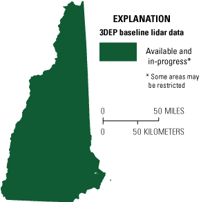
Map of New Hampshire showing status of 3D Elevation Program (3DEP) baseline lidar data as of May 2024. Visit https://usgs.gov/NationalMap/LidarExplorer to find and download currently available data.
Status of 3DEP in New Hampshire
Acquisition of quality level 1 lidar data through a legislative Capital Budget appropriation in combination with funding through 3DEP occurred in 2019. This represents the first regionally extensive quality level 1 dataset to become available for New Hampshire.
Natural Resources Conservation
High-quality elevation data enable State, regional, Tribal, and local governments to more effectively implement natural resources conservation practices and reduce costs to the public. Where statewide lidar data are available, public and private organizations can expand their use of lidar for (1) planning and site-level engineering to reduce fieldwork for conservation ponds, grassed waterways, pipelines, and terracing, and (2) accurately calculating runoff, identifying historical (drained) wetlands, and planning wetland restoration.
Forest Resources Management
According to Jasen Stock, executive director of the New Hampshire Timberland Owners Association, “The forest products industry in New Hampshire employs more than 7,200 people and is tied to an additional 5,500 jobs in support and related industries. The industry generates $1.6 billion annually in economic activity and is a critical economic engine and source of jobs in rural areas” (Foley, 2020). Accurate characterizations of forest resources for biomass estimation, species quantification, and habitat suitability are basic requirements for maximizing this economic impact. Management of forest activities also requires wet-area mapping as well as change detection in aboveground vegetation, both of which are greatly enhanced with accurate digital elevation models and classified lidar point clouds.
Flood Risk Management
The New Hampshire Geological Survey and the Dam Bureau within the New Hampshire Department of Environmental Services provide information and applications that can be used by the public and commercial sectors to plan and respond to events. Partnerships are key to the agency’s success in preventing and mitigating flood hazards. Lidar data provide high-quality terrain information (fig. 2) as input for more accurate and less expensive hydrologic and hydraulic modeling for flood studies, retention-dam design, dam breach studies, and stormwater management and engineering. This information can be used to identify vulnerable properties within a flood plain, facilitate better flood-plain management decisions, and educate the public on flood-risk zones by providing dynamic 3D models to show the potential effects of flooding from major storm events.
Table 2.
Conservative benefits estimates for the top nine New Hampshire business uses of the proposed 3DEP data identified in the National Enhanced Elevation Assessment (Dewberry, 2012).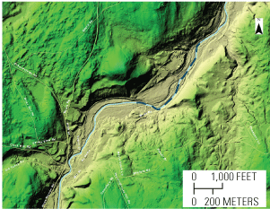
Lidar image of the South Branch Piscataquog River at New Boston, New Hampshire. Dashed dark-blue line overprinted on the river shows the location and extent of the half-mile-long 2018 ice jam. The head of the jam is at the left (upstream) end of the line. Image courtesy of Shane Csiki, New Hampshire State Geologist.
3D Elevation Program (3DEP)
The 3D Elevation Program is managed by the U.S. Geological Survey (USGS) on behalf of the community of Federal, State, Tribal, local, and other partners and users of elevation data. In response to growing needs for high-quality elevation data, the goal of 3DEP is to complete acquisition of nationwide light detection and ranging (lidar) data (interferometric synthetic aperture radar [IfSAR] data in Alaska) to provide the first-ever national baseline of consistent, high-resolution topographic elevation data—both bare-earth digital elevation models and 3D point clouds.
Benefits
-
• Economies of scale by acquiring data for larger areas.
-
• Predictable and flexible Federal investments that can reduce costs and allow better planning.
-
• Consistent national coverage that provides data for applications that span project, jurisdictional, and watershed boundaries.
-
• Simplified data acquisition that provides contracts, project management, quality assurance, and published data specifications.
-
• National benefits of $690 million per year conservatively, with the potential to generate $13 billion per year in additional benefits through applications that span the economy (Dewberry, 2012).
High-Quality Data and Products
3DEP lidar data provide coverage with a minimum of two points per square meter and a vertical error not to exceed 10 centimeters, measured as root mean square error in the elevation (z) dimension (RMSEz) (table 1). 3DEP baseline lidar data products include all data points collected (point clouds) and bare-earth digital elevation models with a 1-meter or better resolution. The USGS integrates the elevation data into The National Map. Data are available free of charge and without use restrictions. To download 3DEP products visit https://apps.nationalmap.gov/downloader/.
Ways to Participate
Participation in 3DEP is open to Federal, State, Tribal, U.S. territorial, and local government partners, as well as private sector partners, and offers the option to acquire even higher quality data. Partners may contribute funds toward projects managed by the USGS, or they may receive cooperative funds to manage their own projects. An annual Data Collaboration Announcement is the mechanism used to establish partner agreements. Organizations and the private sector may contribute existing data that meet 3DEP requirements. For more information refer to the 3DEP website at https://www.usgs.gov/3DEP/collaborate/.
References Cited
Dewberry, 2012, National Enhanced Elevation Assessment final report (revised March 29, 2012): Fairfax, Va., Dewberry, 84 p. plus appendixes, accessed May 27, 2024, at https://www.dewberry.com/services/geospatial/national-enhanced-elevation-assessment.
Foley, M., 2020, NH forest-products industry lumbers on amid COVID, other challenges: The Keene Sentinel, June 25, 2020, updated August 1, 2020, accessed May 27, 2024, at https://www.sentinelsource.com/news/local/nh-forest-products-industry-lumbers-on-amid-covid-other-challenges/article_9c9a76.
Heidemann, H.K., 2012, Lidar base specification (ver. 1.2, November 2014): U.S. Geological Survey Techniques and Methods, book 11, chap. B4, 67 p. with appendixes, accessed May 27, 2024, at https://doi.org/10.3133/tm11B4.
Sugarbaker, L.J., Constance, E.W., Heidemann, H.K., Jason, A.L., Lukas, V., Saghy, D.L., and Stoker, J.M., 2014, The 3D Elevation Program initiative—A call for action: U.S. Geological Survey Circular 1399, 35 p., accessed May 27, 2024, at https://doi.org/10.3133/cir1399.
For Further Information:
Director, National Geospatial Program
U.S. Geological Survey, MS 511
12201 Sunrise Valley Drive
Reston, VA 20192
Email: 3DEP@usgs.gov
USGS National Map Liaison:
Adam Benthem
Email: abenthem@usgs.gov
Disclaimers
Any use of trade, firm, or product names is for descriptive purposes only and does not imply endorsement by the U.S. Government.
Although this information product, for the most part, is in the public domain, it also may contain copyrighted materials as noted in the text. Permission to reproduce copyrighted items must be secured from the copyright owner.
Suggested Citation
Walters, D.H., 2024, The 3D Elevation Program—Supporting New Hampshire’s economy: U.S. Geological Survey Fact Sheet 2024–3056, 2 p., https://doi.org/10.3133/fs20243056.
ISSN: 2327-6932 (online)
Study Area
| Publication type | Report |
|---|---|
| Publication Subtype | USGS Numbered Series |
| Title | The 3D Elevation Program—Supporting New Hampshire’s economy |
| Series title | Fact Sheet |
| Series number | 2024-3056 |
| DOI | 10.3133/fs20243056 |
| Publication Date | December 27, 2024 |
| Year Published | 2024 |
| Language | English |
| Publisher | U.S. Geological Survey |
| Publisher location | Reston, VA |
| Contributing office(s) | National Geospatial Program |
| Description | 2 p. |
| Country | United States |
| State | New Hampshire |
| Online Only (Y/N) | Y |
| Additional Online Files (Y/N) | N |