

U.S. Geological Survey National Groundwater Climate Response Network
Links
- Document: Report (425 KB pdf) , HTML , XML
- Download citation as: RIS | Dublin Core
The U.S. Geological Survey’s National Water Monitoring Network is a set of national water data collection networks that support the U.S. Geological Survey’s mission to protect life, property, the environment, and the economy of the Nation.
What is the U.S. Geological Survey National Groundwater Climate Response Network?
The U.S. Geological Survey’s (USGS) National Water Monitoring Network is a network of networks that includes the Climate Response Network (CRN). The CRN is a network of wells selected to monitor the effects of climate variability, including droughts, on groundwater systems within the United States, Puerto Rico, and the U.S. Virgin Islands. The primary purpose of the CRN is to monitor these effects on groundwater levels in unconfined or near-surface confined aquifers that are minimally affected by pumping or other human-induced stresses.
The Climate Response Network is Designed to Help Answer Two Important Questions
-
• What are the current conditions of our Nation’s groundwater levels?
-
• How are climatic conditions affecting our Nation’s groundwater levels?
The CRN provides the water-level data needed to understand how changing climate affects groundwater systems nationwide. Data provided by the CRN form the basis for assessments and models that characterize the connections between climate and groundwater levels (depth to water below land surface).
Building on Decades of Monitoring
Water-level measurements from observation wells are the primary source of information about the effects of hydrologic stresses on groundwater systems (Taylor and Alley, 2001). The USGS uses consistent data-collection and quality-control methods to measure real-time water levels nationwide at more than 2,000 sites (United States Geological Survey, 2024b). A subset of these wells is included in the CRN.
The CRN network is designed is to have at least 1 monitored site within each of the Nation’s 366 climate divisions in the United States, Puerto Rico, and the Virgin Islands (United States Geological Survey, 2016; Luo and others, 2024; National Oceanic and Atmospheric Administration, 2024). In 2006, the CRN operated approximately 140 federally funded wells (Cunningham and others, 2007). At its peak (2021–23), the CRN included federally funded data collection at 256 sites representing nearly 70 percent of the Nation’s climate divisions.
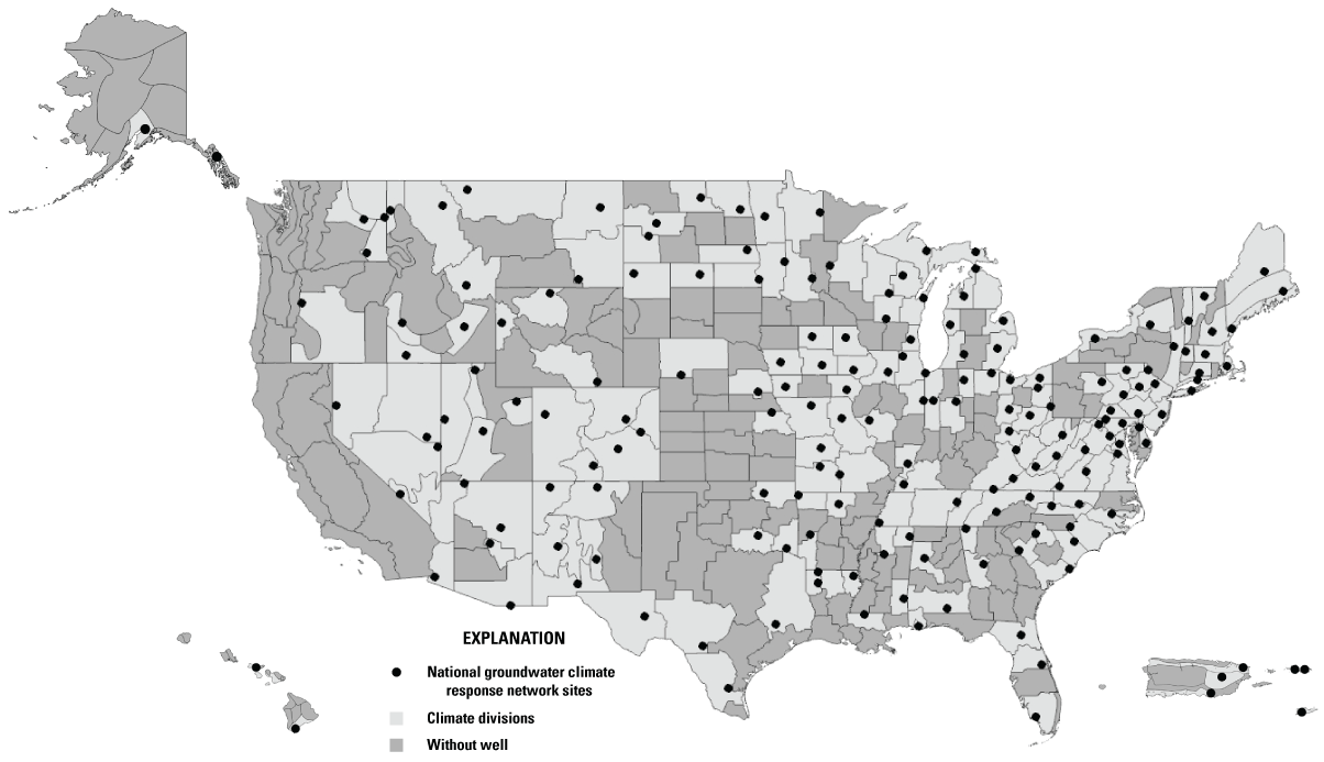
The 2024 federally funded National Groundwater Climate Response Network sites.
The Climate Response Network in 2024
In 2024, the USGS monitors 186 federally funded wells located within about 51 percent of the Nation’s climate divisions across the United States and its territories as part of the CRN (fig. 1). The CRN also includes over 400 supplemental sites located mostly in the eastern United States monitored in cooperation with State, Local, Regional, Tribal, or other Federal partners.
-
• Federally-funded sites: These sites are authorized by the SECURE Water Act of 2009 (U.S. Congress, 2009) through the USGS Groundwater and Streamflow Information Program (U.S. Geological Survey, 2024a). Groundwater levels are continuously measured at 15- to 60-minute intervals with water level sensors and regularly transmit data to USGS databases. These data are available for viewing on the Water Data for the Nation website (U.S. Geological Survey, 2024b).
-
• Supplemental sites: The frequency of groundwater-level measurements ranges from periodic (monthly–quarterly) manual measurements to continuously measured. Currently, there are over 300 real-time supplemental sites in the CRN.
Criteria for Climate Response Network Sites
Generally, observation wells tend to be concentrated in areas where aquifers are heavily developed. In contrast, the CRN sites (fig. 2) are intentionally located away from the influence of water-supply pumping, irrigation, and other human activities to allow for monitoring of the natural effects of climate variability. Additionally, the following are the criteria for inclusion in the CRN:
-
• Open to a single, known hydrogeologic unit;
-
• Located in unconfined aquifers or near-surface confined aquifers;
-
• Known well construction;
-
• Long-term accessibility; and
-
• Unlikely to go dry.
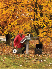
U.S. Geological Survey (USGS) hydrologic technician measures a groundwater level at a Climate Response Network monitoring well in Worcester County, Massachusetts (USGS station 422058072085101). Photograph by Samuel Banas, USGS, October 2022.
Tracking the Response of Climate Variability in Our Nation’s Groundwater Systems
The collection of water-level data to adequately assess water-level trends, including the effects of climate variability and regional aquifer development, typically requires years or decades (Taylor and Alley, 2001). Currently, the average period of record among the federally funded CRN sites is over 37 years, and 53 of the 186 sites have over 50 years of groundwater level records. The longest running CRN well is a 31-foot-deep, hand-dug well located in Oneida County, New York (USGS station 433112075091501), that has groundwater measurements from 1926 to present (fig. 3). located in Oneida County, New York. The graph has a nearly complete record of groundwater levels dating back to 1926, broken only during a period in the late 1940s.
![Groundwater hydrograph from a Climate Response Network monitoring well (U.S. Geological
Survey [USGS] station 433112075091501) located in Oneida County, New York. The graph
has a nearly complete record of groundwater levels dating back to 1926, broken only
during a period in the late 1940s.](https://pubs.usgs.gov/fs/2024/3057/images/fs20243057_fig03.png)
Groundwater hydrograph from a Climate Response Network monitoring well (U.S. Geological Survey [USGS] station 433112075091501) located in Oneida County, New York. The graph has a nearly complete record of groundwater levels dating back to 1926, broken only during a period in the late 1940s.
Data Access
Data are available through the USGS Groundwater Climate Response Network websites accessible at https://rconnect.usgs. gov/crnmap/CRNmap.html and https:// dashboard.waterdata.usgs.gov/.
References Cited
Cunningham, W.L., Geiger, L.H., and Karavitis, G.A., 2007, U.S. Geological Survey Ground-Water Climate Response Network: U.S. Geological Survey Fact Sheet 2007–3003, 4 p. [Also available at https://pubs.usgs.gov/fs/2007/3003/.]
Luo, X., Frazier, A.G., Diaz, H.F., Longman, R., and Giambelluca, T.W., 2024, Routine Climate Monitoring in the State of Hawai’i—Establishment of State Climate Divisions: Bulletin of the American Meteorological Society, v. 105, no. 6, 17 p., accessed November 25, 2024, at https://doi.org/10.1175/BAMS-D-23-0236.1.
National Oceanic and Atmospheric Administration, 2024, Geographical reference maps: National Oceanic and Atmospheric Administration National Centers for Environmental Information website, accessed August 28, 2024, at https://www.ncei.noaa.gov/access/ monitoring/reference-maps/.
Taylor, C.J., and Alley, W.M., 2001, Ground-water-level monitoring and the importance of long-term water-level data: U.S. Geological Survey Circular 1217, 68 p. [Also available at https://pubs.usgs.gov/circ/circ1217/.]
U.S. Congress, 2009, Secure Water Facilities Act— Public Law 111-11, subtitle F: 111th U.S. Congress, 107 p., accessed November 14, 2024, at https:// www.congress.gov/bill/111th-congress/ senate-bill/3598/text.
U.S. Geological Survey, 2016, Climate of Puerto Rico: U.S. Geological Survey website, accessed August 28, 2024, at https://www.usgs.gov/centers/cfwsc/ science/climate-puerto-rico.
U.S. Geological Survey, 2024a, Groundwater and Streamflow Information Program: U.S. Geological Survey webpage, accessed November 11, 2024, athttp://https://www.usgs.gov/programs/groundwater-and-streamflow-information-program.
U.S. Geological Survey, 2024b, National Water Information System: U.S. Geological Survey database, accessed August 28, 2024, at https://waterdata.usgs.gov/nwis/gw.
For more information about the Climate Response Network:
Visit https://www.usgs.gov/mission-areas/water-resources/observing-systems-division
Contact https://pubs.usgs.gov/contact
Layout and design by Yanis X. Castillo
Publishing support provided by the Tacoma Publishing Service Center, U.S. Geological Survey Science Publishing Network
Disclaimers
Any use of trade, firm, or product names is for descriptive purposes only and does not imply endorsement by the U.S. Government.
Although this information product, for the most part, is in the public domain, it also may contain copyrighted materials as noted in the text. Permission to reproduce copyrighted items must be secured from the copyright owner.
Suggested Citation
Caldwell, R.R. and Fine, J.M., 2025, U.S. Geological Survey National Groundwater Climate Response Network: U.S. Geological Survey Fact Sheet 2024–3057, 2 p., https://doi.org/10.3133/fs20243057.
ISSN: 2327-6932 (online)
Study Area
| Publication type | Report |
|---|---|
| Publication Subtype | USGS Numbered Series |
| Title | U.S. Geological Survey National Groundwater Climate Response Network |
| Series title | Fact Sheet |
| Series number | 2024-3057 |
| DOI | 10.3133/fs20243057 |
| Publication Date | January 14, 2025 |
| Year Published | 2025 |
| Language | English |
| Publisher | U.S. Geological Survey |
| Publisher location | Reston, VA |
| Contributing office(s) | WMA - Observing Systems Division |
| Description | 2 p. |
| Country | United States |
| Online Only (Y/N) | Y |