

The 3D Elevation Program—Supporting Utah’s Economy
Links
- Document: Report (685 KB pdf) , HTML , XML
- Download citation as: RIS | Dublin Core
Introduction
High-quality elevation data for Utah inform decision making to improve the State’s economy. Light detection and ranging (lidar) data are used to support infrastructure planning and management, assess natural resources, and improve resiliency to hazards. The expanding availability of current and more accurate lidar data helps to better support natural resource conservation, wildfire risk management, geologic hazard investigation and mitigation, flood risk management, water supply planning, and urban planning and development. Critical applications that meet the State’s management needs depend on lidar data that provide a highly detailed three-dimensional (3D) model of the Earth’s surface and aboveground features.
The 3D Elevation Program (3DEP; refer to sidebar) is managed by the U.S. Geological Survey (USGS) in partnership with Federal, State, Tribal, U.S. territorial, and local agencies to acquire consistent lidar coverage at quality level 2 or better (table 1) to meet the many needs of the Nation and Utah. The status of available and in-progress 3DEP baseline lidar data in Utah is shown in figure 1. 3DEP baseline lidar data include quality level 2 or better, 1-meter or better digital elevation models, and lidar point clouds, and must meet the Lidar Base Specification version 1.2 (https://www.usgs.gov/3dep/lidarspec) or newer requirements. The National Enhanced Elevation Assessment (Dewberry, 2012) identified user requirements and conservatively estimated that availability of lidar data would result in at least $8.70 million in new benefits annually to the State. The top 10 Utah business uses for 3D elevation data, which are based on the estimated annual conservative benefits of 3DEP, are shown in table 2.
Table 1.
Data quality levels, pulse spacing, and pulse density. Quality level 2 or better lidar data meet 3DEP requirements.[Specifications for quality level 0 (QL0) are from Heidemann (2012, p. 3 and table 1); for quality levels 1 and 2, specifications are from Sugarbaker and others (2014, table 1). In the quality level column, QL0 represents the highest level of quality. RMSEz, root mean square error in the elevation (z) dimension; cm, centimeter; m, meter; pls/m2, first return pulses per square meter; ≤, less than or equal to; ≥, greater than or equal to]
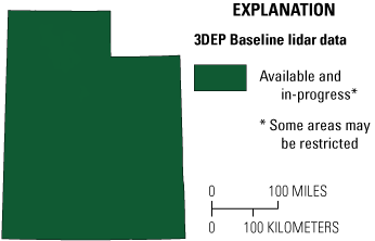
Map of Utah showing status of 3D Elevation Program (3DEP) baseline lidar data as of March 2024. Visit https://usgs.gov/NationalMap/LidarExplorer to find and download currently available data.
Table 2.
Conservative benefits estimates for the top 10 Utah business uses of the proposed 3DEP data identified in the National Enhanced Elevation Assessment (Dewberry, 2012).Status of 3DEP in Utah
The State of Utah is second in the Nation for its percentage of federally owned land at 64 percent. Funding and collection of lidar has been a collaborative effort between various Federal (80 percent) and non-Federal (20 percent) partners. The Utah Geospatial Resource Center (UGRC) provides a wide range of geographic information system (GIS) and other geospatial support services. UGRC strives to ensure a high level of coordination among Utah GIS users and effective, efficient use of GIS resources. UGRC coordination has played a significant role in the completion of lidar coverage.
Since 2022, six partner agencies have contributed to three large projects with a total value over $6 million. These projects, along with 3DEP acquisitions by federal partners such as Federal Emergency Management Agency, U.S. Forest Service, U.S. Fish and Wildlife, Natural Resources Conservation Service, and USGS, have achieved completion of statewide 3DEP baseline lidar coverage in 2024. Next steps for the State include higher resolution (quality level 1) data in certain areas, maintaining quality level 2 coverage across Utah, and improving the quality and density of hydrography data based on lidar data.
Flood Risk Management
A significant percentage of Utah’s population lives in areas susceptible to flash flooding, but much of this flood risk is not identified, and this is especially true along intermittent or ephemeral streams. As a result, it is becoming increasingly important to map flood risk accurately to reduce costs and save human lives. High-quality elevation data can allow Utah’s Risk MAP Program to map flood risk areas not yet identified and revise current outdated flood risk information to better define the risk. Local and Tribal governments use lidar data as a tool for development planning and flood mitigation efforts.
Natural Resource Conservation
The Utah Department of Natural Resources; the U.S. Department of Agriculture (USDA), Forest Service; and the USDA, Natural Resources Conservation Service, all use elevation data for natural resource management applications including wildfire management, vegetation management, conservation engineering, soils and wetlands mapping and characterization, riverine ecosystem management, modeling of biological and ecological systems, erosion control (fig. 2), and recreation.
The economic significance of a broad range of activities in and around the Great Salt Lake is over $1.3 billion annually (Great Salt Lake Advisory Council, 2021, p. 3). Uses of the lake’s resources include brine shrimp harvesting, salt and mineral extraction, recreational activities, and wildlife habitat conservation. As the lake level fluctuates due to climate change and reduced water availability, understanding the changing shoreline and water volume using topographic and bathymetric lidar can inform decision making regarding this unique feature and the threats it faces.
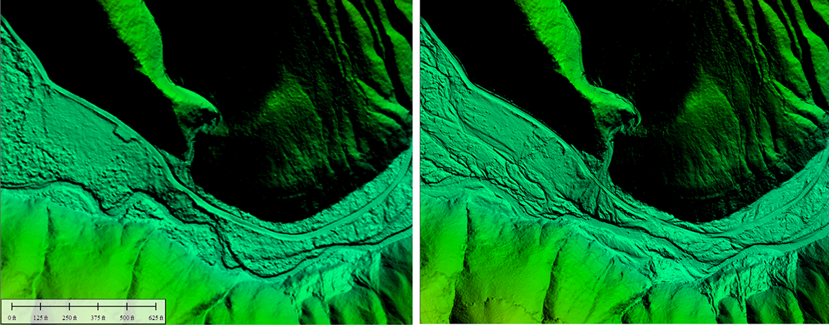
The Dollar Ridge Fire in early July 2018 burned over 100 square miles near the Strawberry River in Wasatch and Duchesne Counties (Utah Division of Wildlife Resources, 2019). Later that month, a storm over the burn scar produced major debris flows and flooding, as ash and sediment were unconstrained due to the fire damage. Left, quality level 2 lidar collected in the spring of 2018 prior to the fire. Right, quality level 1 lidar collected in August 2019 in which sediment deposits and the modified river channel are visible. Lidar can be used for rehabilitation efforts such as revegetation planning, slope stabilization, and watershed restoration. Images by Claire DeVaughan, U.S. Geological Survey.
Geologic Resource Assessment and Hazard Mitigation
With a wide range of geologic resources and hazards in the State, the Utah Geological Survey utilizes lidar for applications including geologic mapping and analysis, karst mapping, aquifer recharge, and geothermal energy resource development potential. Lidar is also used for identification of hazards such as landslides, debris flows, and faults, and as an aid in mitigating and responding to geologic hazards.
3D Elevation Program (3DEP)
The 3D Elevation Program is managed by the U.S. Geological Survey (USGS) on behalf of the community of Federal, State, Tribal, local, and other partners and users of elevation data. In response to growing needs for high-quality elevation data, the goal of 3DEP is to complete acquisition of nationwide light detection and ranging (lidar) data (interferometric synthetic aperture radar [IfSAR] data in Alaska) to provide the first-ever national baseline of consistent, high-resolution topographic elevation data—both bare-earth digital elevation models and 3D point clouds.
Benefits
-
• Economies of scale by acquiring data for larger areas.
-
• Predictable and flexible Federal investments that can reduce costs and allow better planning.
-
• Consistent national coverage that provides data for applications that span project, jurisdictional, and watershed boundaries.
-
• Simplified data acquisition that provides contracts, project management, quality assurance, and published data specifications.
-
• National benefits of $690 million per year conservatively, with the potential to generate $13 billion per year in additional benefits through applications that span the economy (Dewberry, 2012).
High-Quality Data and Products
3DEP lidar data provide coverage with a minimum of two points per square meter and a vertical error not to exceed 10 centimeters, measured as root mean square error in the elevation (z) dimension (RMSEz) (table 1). 3DEP baseline lidar data products include all data points collected (point clouds) and bare-earth digital elevation models with a 1-meter or better resolution. The USGS integrates the elevation data into The National Map. Data are available free of charge and without use restrictions. To download 3DEP products visit https://apps.nationalmap.gov/downloader/.
Ways to Participate
Participation in 3DEP is open to Federal, State, Tribal, U.S. territorial, and local government partners, as well as private sector partners, and offers the option to acquire even higher quality data. Partners may contribute funds toward projects managed by the USGS, or they may receive cooperative funds to manage their own projects. An annual Data Collaboration Announcement is the mechanism used to establish partner agreements. Organizations and the private sector may contribute existing data that meet 3DEP requirements. For more information refer to the 3DEP website at https://www.usgs. gov/3DEP/collaborate/.
References Cited
Dewberry, 2012, National Enhanced Elevation Assessment final report (revised March 29, 2012): Fairfax, Va., Dewberry, 84 p. plus appendixes, accessed April 19, 2024 at https://www.dewberry.com/services/ geospatial/national-enhanced-elevation-assessment.
Great Salt Lake Advisory Council, 2021, 11th Annual Report to the Utah State Legislature, Natural Resources Appropriations Subcommittee: Great Salt Lake Advisory Council report, 4 p., accessed April 19, 2024 at https://documents.deq.utah.gov/water-quality/ standards-technical-services/great-salt-lake-advisory-council/annual-reports/DWQ-2021- 008732.pdf.
Heidemann, H.K., 2012, Lidar base specification (ver. 1.2, November 2014): U.S. Geological Survey Techniques and Methods, book 11, chap. B4, 67 p. with appendixes, accessed April 19, 2024 at https://doi.org/https://doi.org/10.3133/tm11B4.
Sugarbaker, L.J., Constance, E.W., Heidemann, H.K., Jason, A.L., Lukas, V., Saghy, D.L., and Stoker, J.M., 2014, The 3D Elevation Program initiative—A call for action: U.S. Geological Survey Circular 1399, 35 p., accessed April 19, 2024 at https://doi.org/10.3133/cir1399.
Utah Division of Emergency Management, November 2023, Utah Risk Map: Mapping and analyzing risk to help Utah communities reduce the impacts of flooding, accessed April 19, 2024 at https://floodhazards.utah.gov/mapping/.
Utah Division of Wildlife Resources, 2019, Utah’s Watershed Restoration Initiative—Dollar Ridge fire rehabilitation: Utah Division of Wildlife Resources, accessed April 19, 2024, at https://wri.utah.gov/wri/reports/ProjectSummaryReport.html?id=4752.
For Further Information:
Director, National Geospatial Program
U.S. Geological Survey, MS 511
12201 Sunrise Valley Drive
Reston, VA 20192
Email: [email protected]
USGS National Map Liaison:
Cynthia L. Ritmiller; Email: [email protected]
Disclaimers
Any use of trade, firm, or product names is for descriptive purposes only and does not imply endorsement by the U.S. Government.
Although this information product, for the most part, is in the public domain, it also may contain copyrighted materials as noted in the text. Permission to reproduce copyrighted items must be secured from the copyright owner.
Suggested Citation
Ritmiller, C., 2025, The 3D Elevation Program—Supporting Utah’s economy: U.S. Geological Survey Fact Sheet 2025–3004, 2 p., https://doi.org/10.3133/fs20253004.
ISSN: 2327-6932 (online)
Study Area
| Publication type | Report |
|---|---|
| Publication Subtype | USGS Numbered Series |
| Title | The 3D Elevation Program—Supporting Utah’s economy |
| Series title | Fact Sheet |
| Series number | 2025-3004 |
| DOI | 10.3133/fs20253004 |
| Publication Date | February 05, 2025 |
| Year Published | 2025 |
| Language | English |
| Publisher | U.S. Geological Survey |
| Publisher location | Reston, VA |
| Contributing office(s) | National Geospatial Program |
| Description | 2 p. |
| Country | United States |
| State | Utah |
| Online Only (Y/N) | Y |
| Additional Online Files (Y/N) | N |