

Using Machine Learning in Minnesota’s StreamStats to Predict Fluvial Sediment
Links
- Document: Report (19 KB pdf) , HTML , XML
- NGMDB Index Page: National Geologic Map Database Index Page (html)
- Download citation as: RIS | Dublin Core
Acknowledgments
This report presents a compilation of information, resources, and expertise supplied by many individuals. Authors would like to thank Hans Vraga, Julia Prokopec, Peter McCarthy, and Christopher Ellison of the U.S. Geological Survey for their invaluable guidance and support throughout the project. A major thank you is also due to the many U.S. Geological Survey hydrologic technicians who worked diligently across the State, often enduring long days and extensive travel to collect the critical data that made this effort possible.
We also acknowledge the important collaboration between the Minnesota Pollution Control Agency, the Minnesota Department of Natural Resources, the U.S. Army Corps of Engineers, the Minnesota Wild Rice Watershed District, the Rice Creek Watershed District, and the Lower Minnesota Watershed District for their funding contributions for the fluvial sediment data collection, which was foundational to the project.
Introduction
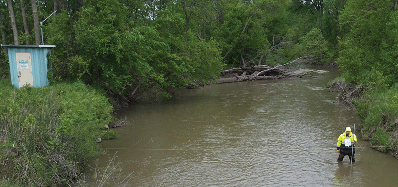
A thorough understanding of fluvial sediment transport is essential for addressing key environmental issues such as aquatic habitat degradation, flooding, excess nutrients, and challenges with river restoration. Fluvial sediment samples are valuable for addressing these concerns, but their collection is often impractical across all rivers and timeframes of interest. In addition, previously used analytical and numerical methods (Gray and Simões, 2008; Ellison and others, 2016) have not allowed for the transfer of knowledge from sites that have data to sites that do not have data. To overcome this limitation, the U.S. Geological Survey (USGS) developed machine learning (ML) models to predict suspended-sediment concentrations (SSCs) and bedload transport (BL) in Minnesota rivers that lack physical sediment data.
Objective
The USGS's primary goal of developing ML models was to enhance sediment transport predictions and provide insights into sediment transport dynamics in Minnesota rivers. These ML models were trained using physical sediment samples, streamflow time series, and geospatial datasets describing watershed, catchment, near-channel, and channel characteristics.
Machine Learning Models for Fluvial Sediment Prediction
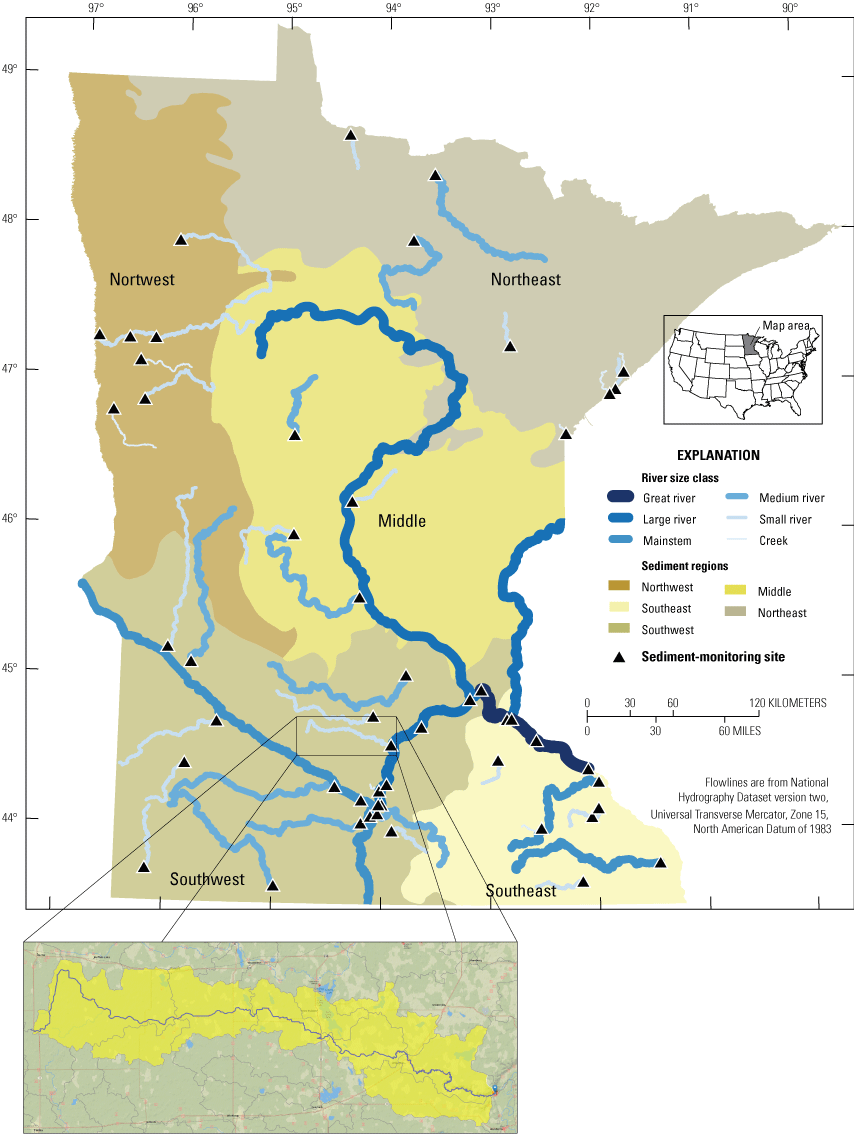
The USGS trained and validated the ML models with approximately 1,300 SSC samples from 56 sites and 600 BL samples from 43 sites across Minnesota (Lund and Groten, 2022; Lund and others, 2022). The ML models incorporate key features such as streamflow, watershed and catchment characteristics, and rate of change in streamflow (slope), which help explain sediment transport processes. The ML models explained approximately 70 percent of the variability in the SSC and BL samples (Lund and Groten, 2022; Lund and others, 2022). These ML models improved sediment transport predictions for rivers and streams with little or no physical sediment data by leveraging the ability of ML to learn complex nonlinear relations and transfer knowledge from sites with data to sites without data available.
StreamStats Integration
In response to the complexity of these ML models and the challenges of applying them, the USGS collaborated with the Minnesota Pollution Control Agency to integrate the ML models into the USGS StreamStats web application. This integration is the first time ML models for sediment prediction have been incorporated into StreamStats, making them accessible by way of a user-friendly interface.
Using StreamStats Fluvial Sediment Prediction Tool
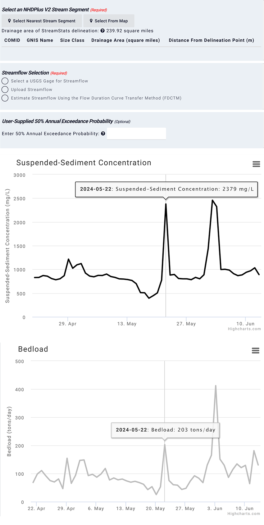
StreamStats users can now access predictions of SSC and BL at Minnesota rivers that lack physical sediment samples. The tool provides three options for streamflow data input used to run the ML models:
-
• Select a USGS streamgage—Use existing streamflow data from a USGS streamgage.
-
• Upload streamflow data—Upload a comma-separated values file with daily or 15-minute streamflow data. Additional streamflow data can be found on the Minnesota Department of Natural Resources Cooperative Stream Gaging website: https://www.dnr.state.mn.us/waters/csg/index.html.
-
• Estimate streamflow using flow duration curve transfer method—Estimate streamflow when data are unavailable.
Once users complete the required steps to run the ML models in StreamStats, the features used and the corresponding outputs will be available in graphical and comma-separated values formats.
Model Limitations and Data Gaps
Although the ML models cover the State of Minnesota, users may not be able to run the ML models at specific sites for a variety of reasons, including an incorrect basin delineation and (or) incomplete datasets at a specific site. The tool will not run on smaller-sized streams and does not output predictions beyond the range of data used to train the ML models (for example, SSC greater than 7,040 milligrams per liter and BL greater than 1,885 tons per day).
Benefits
These ML-based predictions provide several key benefits:
-
• Cost savings—Provides sediment transport predictions when funds are unavailable to conduct extensive field sampling.
-
• Water-quality monitoring—Identify streams that deviate from established water-quality standards.
-
• River restoration—Inform river restoration planning and prioritization.
Integration of these ML models into StreamStats is a major step forward in leveraging ML innovations to better support water and natural resources management.
Sediment Monitoring in Minnesota
Despite the critical need for fluvial sediment data, funding for monitoring programs has fluctuated throughout the years, affecting the continuity and scope of sampling efforts. After a decline in the 1990s (Ellison and others, 2014), funding for sediment monitoring in Minnesota surged with the approval of the Clean Water, Land and Legacy Amendment in 2008, which established the Clean Water Fund (Minnesota’s Legacy and Trust Funds, 2025) enabling the expansion of the USGS sediment-monitoring network in collaboration with the Minnesota Pollution Control Agency and the Minnesota Department of Natural Resources. However, as funding priorities shifted toward restoration in recent years, the number of monitoring sites decreased, and by 2025, no active USGS sediment-monitoring sites remain in the State. Despite these challenges, the long-term records collected by the USGS remain essential for understanding trends in sediment transport, informing water-quality standards, and supporting river restoration efforts. Continued commitment to fluvial sediment sampling is crucial to maintaining these ML models and advancing effective management strategies.
Summary
The incorporation of ML models into the USGS StreamStats application represents an important innovation in predicting fluvial sediment transport. These ML models provide a powerful tool for researchers, water managers, and policymakers, enabling more efficient decision making regarding water quality, habitat preservation, and river restoration in Minnesota.
For More Information
-
• USGS StreamStats (https://streamstats.usgs.gov/ss/)
-
• Minnesota Department of Natural Resources Cooperative Stream Gaging (https://www.dnr.state.mn.us/waters/csg/index.html)
References Cited
Gray, J.R., and Simões, F.J.M., 2008, Estimating sediment discharge, Appendix D of García, M.H., ed., Sedimentation engineering—Processes, measurements, modelling, and practice: American Society of Civil Engineers, p. 1067–1088, accessed January 2025 at https://doi.org/10.1061/9780784408148.apd.
Ellison, C.A., Groten, J.T., Lorenz, D.L., and Koller, K.S., 2016, Application of dimensionless sediment rating curves to predict suspended-sediment concentrations, bedload, and annual sediment loads for rivers in Minnesota (ver. 1.1, January 2020): U.S. Geological Survey Scientific Investigations Report 2016–5146, 68 p., accessed January 2025 at https://doi.org/10.3133/sir20165146.
Ellison, C.A., Savage, B.E., and Johnson, G.D., 2014, Suspended-sediment concentrations, loads, total suspended solids, turbidity, and particle-size fractions for selected rivers in Minnesota, 2007 through 2011: U.S. Geological Survey Scientific Investigations Report 2013–5205, 43 p., accessed January 2025 at https://doi.org/10.3133/sir20135205.
Lund, J.W., and Groten, J.T., 2022, Extreme gradient boosting machine learning models, suspended sediment, bedload, and geospatial data, Minnesota, 2007–2019: U.S. Geological Survey data release, accessed January 2025 at https://doi.org/10.5066/P9VOPSEJ.
Lund, J.W., Groten, J.T., Karwan, D.L., and Babcock, C., 2022, Using machine learning to improve predictions and provide insight into fluvial sediment transport: Hydrological Processes, v. 36, no. 8, p. e14648, accessed January 2025 at https://doi.org/10.1002/hyp.14648.
Minnesota’s Legacy and Trust Funds, 2025, Clean Water Fund: Clean Water Legacy Amendment, accessed January 2025 at https://www.legacy.mn.gov/clean-water-fund.
For more information about this publication, contact:
Director, USGS Upper Midwest Water Science Center
2280 Woodale Drive
Mounds View, MN 55112
763–783–3100
For additional information, visit: https://www.usgs.gov/centers/umid-water
Publishing support provided by the
Rolla and Reston Publishing Service Centers
Disclaimers
Any use of trade, firm, or product names is for descriptive purposes only and does not imply endorsement by the U.S. Government.
Although this information product, for the most part, is in the public domain, it also may contain copyrighted materials as noted in the text. Permission to reproduce copyrighted items must be secured from the copyright owner.
Suggested Citation
Groten, J.T., Lund, J.W., Coenen, E.N., Medenblik, A.S., Wavra, H.N., Kennedy, M., and Johnson, G.D., 2025, Using machine learning in Minnesota’s StreamStats to predict fluvial sediment: U.S. Geological Survey Fact Sheet 2025–3005, 4 p., https://doi.org/10.3133/fs20253005.
ISSN: 2327-6932 (online)
Study Area
| Publication type | Report |
|---|---|
| Publication Subtype | USGS Numbered Series |
| Title | Using machine learning in Minnesota’s StreamStats to predict fluvial sediment |
| Series title | Fact Sheet |
| Series number | 2025-3005 |
| DOI | 10.3133/fs20253005 |
| Publication Date | January 30, 2025 |
| Year Published | 2025 |
| Language | English |
| Publisher | U.S. Geological Survey |
| Publisher location | Reston, VA |
| Contributing office(s) | Upper Midwest Water Science Center |
| Description | 4 p. |
| Country | United States |
| State | Minnesota |
| Online Only (Y/N) | Y |
| Additional Online Files (Y/N) | N |