

U.S. Geological Survey 2024 Rocky Mountain Region Science Exchange—Showcasing Cutting-Edge Science to Adapt to Extreme Weather Events and Stakeholder Needs
Links
- Document: Report (1.58 MB pdf) , HTML , XML
- Download citation as: RIS | Dublin Core
Introduction
The Rocky Mountains and the Colorado River Basin in the Western United States are complex, interconnected systems that sustain a large variety of species, including tens of millions of humans. These regions face risks from drought, wildfires, invasive plant and animal species, and habitat reduction. Working with many stakeholders, scientists can help to characterize these risks by providing data and analytical tools to inform land and water resource management decisions.
The U.S. Geological Survey 2024 Rocky Mountain Region (Region 7) Science Exchange Workshop, held in April 2024, focused on cutting-edge science techniques, evaluating complex interconnected risks, and coproducing science with science partners and stakeholders. These science topics and communication strategies can be used for developing data, interpretations, and decision support tools needed to provide science that resource managers and other stakeholders can use to better understand complex, dynamic natural systems and develop management strategies to plan for and adapt to risks that threaten human communities and natural ecosystems.
Cutting-Edge Science Tools for Adapting to Extreme Weather Events
Interactions among humans and natural systems are complex and include land development, wildfires, resource extraction, invasive species introductions, alterations that increase flooding or exacerbate drought, and discharge of wastes. The effects of these actions may be local or global. For instance, wildfires can affect air quality and climate change on national and global scales, and regional droughts and floods of agricultural areas can diminish food supplies over broader areas. Science tools based on emerging technologies and methods can provide the information needed to make effective management decisions for mitigating or adapting to the effects of these challenges.
On the first day of the 2024 workshop, USGS scientists described cutting-edge science methods. Presentations described analyzing combinations of elements, isotopes, and microbes in water to estimate sources of contaminants in western watersheds; modeling hydrologic systems related to salinity loading (Miller and others, 2024); reducing water and sediment sampling costs (Caldwell Eldridge and others, 2023); using high-resolution remote sensing data to develop terrain models and coordinate systems (McLernan and others, 2023); and improving geologic maps of the intermountain West (Turner and others, 2022). These tools can improve understanding of the occurrence and sources of chemical and microbial contaminants of water, changes in land-surface characteristics, and management of public lands.
Science for a Risk-Ready Region
On the second day of the workshop, USGS scientists described evaluating risks relevant to the Rocky Mountain Region that can affect areas beyond the region (fig. 1). Many scientific disciplines, including planetary science, geology, meteorology, wildlife ecology, and civil defense and emergency response can help evaluate complex scenarios of related hazards.
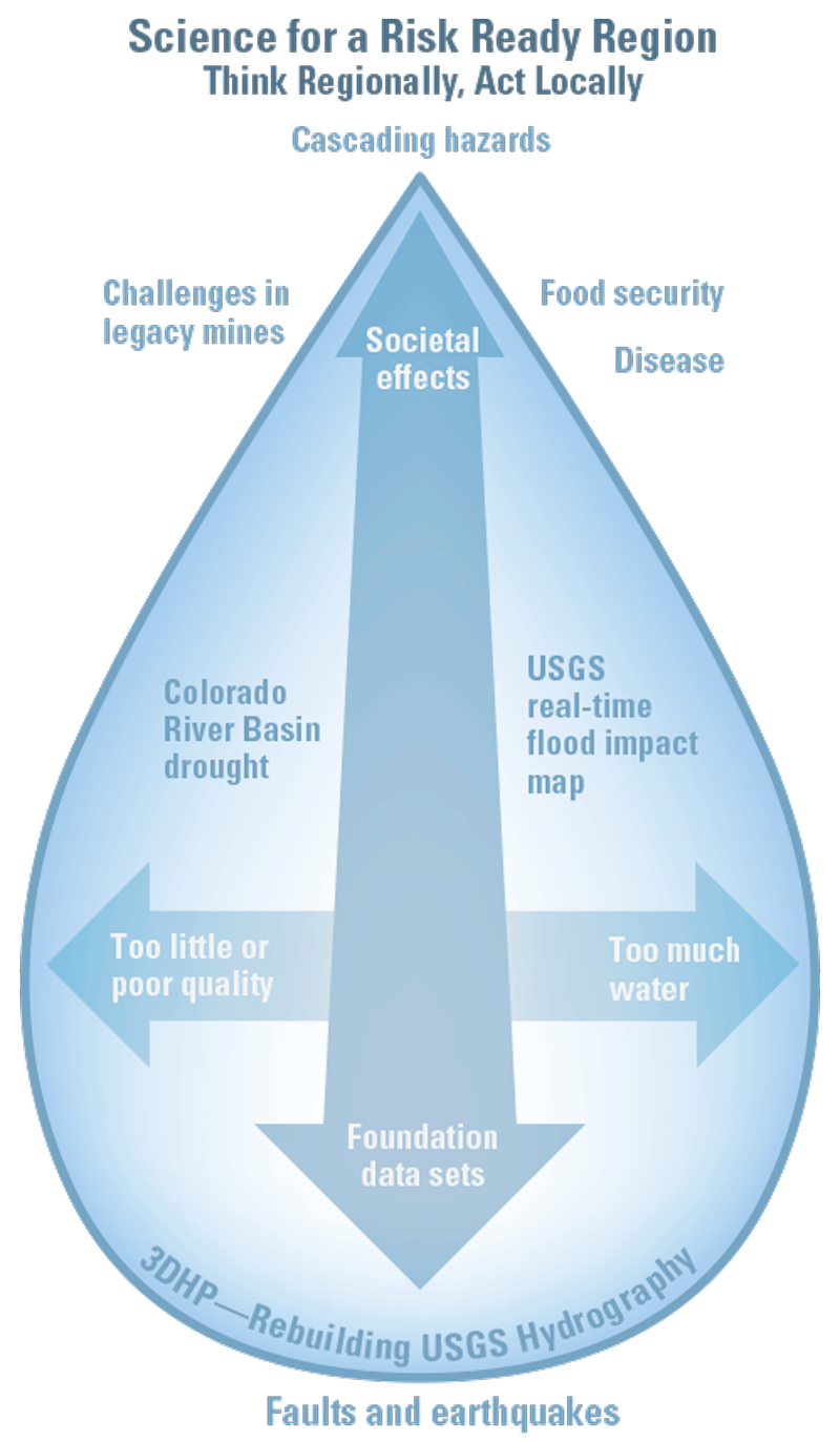
Examples of relations among presentation topics at the 2024 Rocky Mountain Region Science Exchange. 3DHP, 3-Dimensional Hydrography Program
Topics of presentations given during this part of the workshop included water-resource topics such as increasing the resolution of topographic feature maps to improve flooding estimates (Anderson and others, 2024), determining the effects of evaporation on drought conditions (Bern and others, 2024), understanding the scope of multidecadal drought (Bruce and others, 2024), and describing water insecurity in the region (Drakes and others, 2024). Additional presentation topics included defining potential downwind and downstream cascading hazards related to asteroid impacts (Titus and others, 2021; 2023a, b18); estimating recent earthquake frequencies using the ages of minerals and stratigraphy (Cline and others, 2023); using remote-sensing data to evaluate global food security (Oliphant and others, 2022); assessing risks from emerging pathogens in the environment (USGS, 2023; Hubbard and others, 2023); and developing tools to describe risks from hazardous wastes and optimize reclamation of contaminated lands (Manning and others, 2022). These presentations described ways to better understand and prepare for risks in order to make human society and natural ecosystems more resilient to the effects of complex hazards.
Lessons Learned from Stakeholder Engagement and Science Coproduction
On the third day of the workshop, USGS scientists described how engagement with stakeholders and coproduction in science projects can improve the quality and applicability of data, interpretations, and decision-support tools needed by resource managers and stakeholders (fig. 2). Engagement can be defined as a series of levels or degrees of communications during a project, ranging from one-way communications from scientists to stakeholders common in independent research, to equal partnerships of science coproduction.

Increases in the production of science from independent research to equal partnership in full coproduction with shared responsibility for success.
Presentations related to stakeholder engagement and science coproduction given during this part the workshop included using coproduced science projects to optimize resource management, better predict environmental issues, and optimize water-hazards science and incident responses. Presentations related to facilitating science codevelopment and working with stakeholders included working with management agencies and other partners to manage natural resource issues (Christensen and others, 2024; Graham and others, 2022); demonstrating an interactive science collaboration portal (USGS, 2024a); describing science codesign workshops (Dahm and others, 2023); creating a team science curriculum (USGS, 2024b); and developing a science coproduction toolkit to identify best practices for meeting stakeholder needs with multidisciplinary science projects (Selby and others, 2024).
Workshop Outcomes
The 2024 Rocky Mountain Region Science Exchange shared information about three principal topics: cutting-edge science tools, analyses of related natural and human-made hazards, and engagement with scientists across multiple agencies and a broad range of stakeholders to evaluate complex environmental problems. Innovative science methods that can provide a more comprehensive understanding of natural systems and potential means of adaptively managing those systems to reduce system changes caused by humans and other factors were described. Hazard analyses to better understand the cascading interconnection of some risks and make communities and rural areas more resilient to those risks were also described. Increasing stakeholder engagement for collecting and analyzing data can help enhance the effectiveness of tools for adapting to and reducing the effects of natural hazards. These three topics can support science projects and programs to meet the needs of resource managers and stakeholders to better understand natural systems and develop optimal methods for restoring ecosystems and adapting to environmental changes (fig. 3).
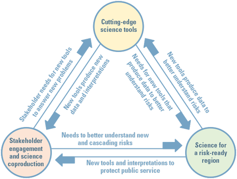
Relations among the three main topics of the 2024 USGS Rocky Mountain Region Science Exchange: cutting-edge science tools, science for a risk-ready region, and lessons learned from stakeholder engagement and science coproduction.

Collecting water samples for evaluation of the source and fate of nutrients in the Animas River watershed, New Mexico, June 9, 2022. Photograph by Benjamin S. Linhoff, U.S. Geological Survey.
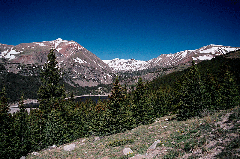
Montgomery Reservoir and Mount Lincoln near Alma, Colorado, June 5, 2005. Photograph by William J. Andrews, U.S. Geological Survey.
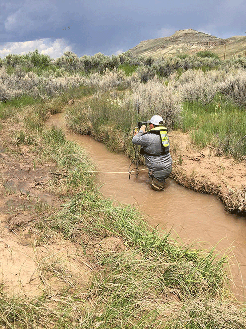
Streamflow measurement made by a U.S. Geological Survey hydrologic technician for the Wyoming Landscape Cooperative Initiative at Fogarty Creek below Fogarty Canyon, near Big Piney, Wyoming, July 17, 2017. Photograph by Cheryl Eddy-Miller, U.S. Geological Survey.
References Cited
Anderson, R., Lukas, V., and Aichele, S.S., 2024, The 3D National Topography Model call for action—Part 1—The 3D Hydrography Program (ver. 1.1, July 2024): U.S. Geological Survey Circular 1519, 12 p., accessed September 9, 2024, at https://doi.org/10.3133/cir1519.
Bern, C., Ruckhaus, M.H., and Scholl, M.A., 2024, Evaporation losses and their effects on river flows in the Colorado River headwaters—Assessment via stable isotopes [abs.] in Water Science Conference 2024, St. Paul, Minnesota, June 24–27, 2024, Abstracts: American Geophysical Union, accessed September 24, 2024, at https://agu.confex.com/agu/hydrology24/meetingapp.cgi/Paper/1504210.
Bruce, J.L., Tillery, A.C., Hevesi, J.A., Holloway, J.M., and Qi, S.L., 2024, Colorado River Basin drought and the 2023 water year: U.S. Geological Survey web page, accessed September 13, 2024, at https://apps.usgs.gov/colorado-river-basin/drought-2023-water-year.html.
Caldwell Eldridge, S.L., Schaar, M.A., Reese, C.B., Bussell, A.M., and Chapin, T., 2023, Sampling and analysis plan for the Koocanusa Reservoir and upper Kootenai River, Montana, water-quality monitoring program, 2021: U.S. Geological Survey Open-File Report 2022–1113, 32 p., accessed September 13, 2024, at https://doi.org/10.3133/ofr20221113.
Christensen, V.G., Crawford, C.J., Dusek, R.J., Focazio, M.J., Fogarty, L.R., Graham, J.L., Journey, C.A., Lee, M.E., Larson, J.H., Stackpoole, V.M., Mazzei, V., Pindilli, E.J., Rattner, B.A., Slonecker, E.T., McSwain, K.B., Reilly, T.J., and Lopez, A.E., 2024, Interdisciplinary science approach for harmful algal blooms (HABs) and algal toxins—A strategic science vision for the U.S. Geological Survey: U.S. Geological Survey Circular 1520, 39 p., accessed September 13, 2024, at https://doi.org/10.3133/cir1520.
Cline, M., Thompson Jobe, J., Reitman, N., and Briggs, R., 2023, Quaternary faulting on the Puye Fault Zone, Espanola Basin, New Mexico [abs.]: Geological Society of America, vol. 55, no. 6, accessed September 13, 2024, at https://doi.org/10.1130/abs/2023AM-395156.
Dahm, K.G., Hawbaker, T., Frus, R.J., Monroe, A.P., Bradford, J.B., Andrews, W.J., Torregrosa, A., Anderson, E.D., Dean, D., and Qi, S.L., 2023, Colorado River Basin Actionable and Strategic Integrated Science and Technology Project—Science strategy: U.S. Geological Survey Circular 1502, 57 p., accessed September 13, 2024, at https://doi.org/10.3133/cir1502.
Drakes, O.O., Restrepo-Osorio, D.L., Powlen, K., and Hines, M.K., 2024, Social vulnerability and water insecurity in the Western United States—A systematic review of framings, indicators, and uncertainty: Water Resources Research, accessed September 13, 2024, at https://doi.org/10.1029/2023WR036284.
Graham, J.L., Cebada Mora, G.M., Gorney, R.M., Ball, L.C., Mengelt, C., and Runge, M.C., 2022, A structured decision-making framework for managing cyanobacterial harmful algal blooms in New York State parks: U.S. Geological Survey Scientific Investigations Report 2022–5053, 22 p., 3 app., accessed September 13, 2024, at https://doi.org/10.3133/sir20225053.
Hubbard, L.E., Givens, C.E., Stelzer, E.A., Killian, M.L., Kolpin, D.W., Szablewski, C.M., and Poulson, R.L., 2023, Environmental surveillance and detection of infectious highly pathogenic avian influenza virus in Iowa wetlands: Environmental Science & Technology Letters, vol. 10, no. 12, p. 1181–1187, accessed September 13, 2024, at https://pubs.acs.org/doi/10.1021/acs.estlett.3c00668.
Manning, A.H., Runkel, R.L., Morrison, J., Wanty, R., and Walton-Day, K., 2022, Incorporating streambank wells in stream mass loading studies to more effectively identify sources of solutes in stream water: Applied Geochemistry, vol. 145, 14 p., accessed September 13, 2024, at https://doi.org/10.1016/j.apgeochem.2022.105425.
McLernan, M.T., Archinal, B.A., Hare, T.M., Skinner, J.A., and Buban, H.C., 2023, Proposed geographic coordinate system for lunar surface navigation and the Artemis missions [abs.] in Sixth Planetary Data Workshop, Flagstaff, Arizona, June 26–28, 2023, Abstracts: The SAO Astrophysics Data System, accessed September 13, 2024, at https://ui.adsabs.harvard.edu/abs/2023LPICo2991.7023M/abstract.
Miller, O.L., Putman, A.L., Smith, R.A., Schwarz, G.E., Hess, M.D., McDonnell, M.C., and Jones, D.K., 2024, Temporal variability in irrigated land and climate influences on salinity loading across the Upper Colorado River Basin, 1986–2017: Environmental Research Letters, vol. 19, no. 2, 14 p., accessed September 13, 2024, at https://doi.org/10.1088/1748-9326/ad18dd.
Oliphant, A., Thenkabail, P., and Teluguntla, P., 2022, Global food-security support-analysis data at 30-m resolution (GFSAD30) cropland-extent products—download analysis: U.S. Geological Survey Open-File Report 2022–1001, 20 p., accessed September 13, 2024, at https://doi.org/10.3133/ofr20221001.
Selby, L.B., Carter, S.K., Haby, T.S., Wood, D.J.A., Bamzai-Dodson, A., Anderson, P.J., Herrick, J.E., Samuel, E.M., and Tull, J.C., 2024, A toolkit for coproducing actionable science to support public land management: Bureau of Land Management, 18 p., accessed September 13, 2024, at https://www.ntc.blm.gov/krc/legacy/course/1189.
Titus, T.N., Robertson, D.G., Sankey, J.B., and Mastin, L.G., 2021, Asteroid impacts—downwind and downstream effects [abs.] in The 7th International Academy of Astronautics Planetary Defense Conference, Vienna, Austria, April 26–30, 2021, Abstracts: International Academy of Astronautics, 3 p., accessed September 13, 2024, at https://az659834.vo.msecnd.net/eventsairwesteuprod/production-atpi-public/b93b51315d3d456087eb02af58f6f858.
Titus, T.N., Robertson, D.G., Sankey J.B., and Mastin, L.G., 2023a, Asteroid impacts and cascading hazards in The 8th International Academy of Astronautics Planetary Defense Conference, Vienna, Austria, April 3–7, 2023, Abstracts: International Academy of Astronautics, 14 p., accessed September 13, 2024, at https://az659834.vo.msecnd.net/eventsairwesteuprod/production-atpi-public/14c878671ada4d01a7e854f1de2a8bae.
Titus, T.N., Robertson, D.G., Sankey, J.B., Mastin, L.G., and Rengers, F.K., 2023b, A review of common natural disasters as analogs for asteroid impact effects and cascading hazards: Natural Hazards, vol. 116, p. 1355–1402, accessed September 13, 2024, at https://doi.org/10.1007/s11069-022-05722-z.
Turner, K.J., Workman, J.B., Colgan, J., Gilmer, A.K., Berry, M.E., Johnstone, S., Warrell, K.F., Dechesne, M., VanSistine, D.P., Thompson, R.A., Hudson, A.M., Zellman, K.L., Sweetkind, D.S., and Ruleman, C.A., 2022, The Seamless Integrated Geologic Mapping (SIGMa) extension to the Geologic Map Schema (GeMS): U.S. Geological Survey Scientific Investigations Report 2022–5115, 33 p., accessed September 13, 2024, at https://doi.org/10.3133/sir20225115.
U.S. Geological Survey [USGS], 2023, Environmental detection of avian influenza virus: U.S. Geological Survey web page, accessed September 13, 2024, at https://www.usgs.gov/centers/upper-midwest-water-science-center/science/environmental-detection-avian-influenza-virus.
U.S. Geological Survey [USGS], 2024a, USGS science collaboration portal for the Colorado River Basin: U.S. Geological Survey web page, accessed September 13, 2024, at https://colorado-river-portal.usgs.gov/.
U.S. Geological Survey [USGS], 2024b, USGS team science curriculum: U.S. Geological Survey web page, accessed September 13, 2024, at https://www.usgs.gov/centers/forest-and-rangeland-ecosystem-science-center/science/usgs-team-science-curriculum.
For More Information
U.S. Geological Survey Rocky Mountain Region: https://www.usgs.gov/regions/rocky-mountain
U.S. Geological Survey Colorado River Basin Actionable and Strategic Integrated Science and Technology project: https://www.usgs.gov/special-topics/colorado-river-basin
Disclaimers
Any use of trade, firm, or product names is for descriptive purposes only and does not imply endorsement by the U.S. Government.
Although this information product, for the most part, is in the public domain, it also may contain copyrighted materials as noted in the text. Permission to reproduce copyrighted items must be secured from the copyright owner.
Suggested Citation
Andrews, W.J., Titus, T.N., Eng, L.E., Zellman, K.L., Anderson, P.J., and Havens, J.C., 2025, U.S. Geological Survey 2024 Rocky Mountain Region Science Exchange—Showcasing cutting-edge science to adapt to extreme weather events and stakeholder needs: U.S. Geological Survey Fact Sheet 2025-3008, 4 p., https://doi.org/10.3133/fs20253008.
ISSN: 2327-6932 (online)
| Publication type | Report |
|---|---|
| Publication Subtype | USGS Numbered Series |
| Title | U.S. Geological Survey 2024 Rocky Mountain Region Science Exchange—Showcasing cutting-edge science to adapt to extreme weather events and stakeholder needs |
| Series title | Fact Sheet |
| Series number | 2025-3008 |
| DOI | 10.3133/fs20253008 |
| Publication Date | April 24, 2025 |
| Year Published | 2025 |
| Language | English |
| Publisher | U.S. Geological Survey |
| Publisher location | Reston VA |
| Contributing office(s) | Astrogeology Science Center, Colorado Water Science Center, Fort Collins Science Center, Geosciences and Environmental Change Science Center, Rocky Mountain Region Director’s Office |
| Description | 4 p. |
| Online Only (Y/N) | Y |