

Assessment of Undiscovered Conventional and Continuous Oil and Gas Resources in the Escondido, Olmos, and San Miguel Formations of the Western Gulf Basin Province, U.S. Gulf Coast Region, 2023
Links
- Document: Report (1.71 MB pdf) , HTML , XML
- Data Release: USGS data release - USGS National and Global Oil and Gas Assessment Project-Gulf Coast Escondido, Olmos, and San Miguel Formations Conventional and Continuous Oil and Gas Assessment Unit Boundaries, Assessment Input Data, and Fact Sheet Data Tables
- NGMDB Index Page: National Geologic Map Database Index Page (html)
- Download citation as: RIS | Dublin Core
Abstract
Using a geology-based assessment methodology, the U.S. Geological Survey estimated undiscovered, technically recoverable mean resources of 5 million barrels of oil and 25 billion cubic feet of gas in conventional reservoirs and 361 million barrels of oil and 10,978 billion cubic feet of gas in continuous reservoirs in the Western Gulf Basin Province of the U.S. Gulf Coast region.
Introduction
The San Miguel Formation of the Campanian Taylor Group, and the Olmos and Escondido Formations of the Campanian-Maastrichtian Navarro Group, consist of shale and sandstone beds that are distributed across and beneath the southern part of the Texas Gulf Coastal Plain, from the San Marcos Arch to the United States-Mexico border in Texas (fig. 1). This area encompasses the Maverick Basin, which is between the United States-Mexico border in Texas and the Frio River line (fig. 1). The formations are known from decades of research (Weise, 1979; Tyler and Ambrose, 1986; Condon and Dyman, 2006), as well as petroleum exploration that extends back to at least the 1930s (IHS Markit, 2022). Minimum estimates of cumulative liquid and gas production for the three formations are at least 170 million barrels of oil (MMBO) and 520 billion cubic feet of gas (BCFG), 130 MMBO and 2,800 BCFG, and 6.8 MMBO and 120 BCFG, respectively.
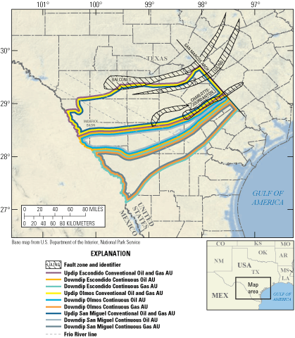
Maps showing the location of nine assessment units (AUs) in the Western Gulf Basin Province, U.S. Gulf Coast region.
The undiscovered oil and gas resources within these formations were last assessed by the U.S. Geological Survey (USGS) in 2003 (Condon and Dyman, 2006). The mean undiscovered resource estimates were 33.22 MMBO, 1,682 BCFG, and 34.26 million barrels of natural gas liquids (MMBNGL), and the bulk of the resources (particularly the gas and natural gas liquids) was located in downdip parts of the area of investigation. Since that time, the widespread use of horizontal drilling and hydraulic fracturing has led to an increase in production rates on a per-well basis in these formations (IHS Markit, 2022). For the 2023 assessment, petroleum system elements for these formations were both adapted from previous work and updated based on new information and analysis methods.
Total Petroleum System and Geologic Model for Assessment
The San Miguel, Olmos, and Escondido Formations are part of the Upper Jurassic–Cretaceous–Tertiary Composite Total Petroleum System in onshore lands of the Texas Gulf Coast region. The primary petroleum source rock for the formations is the Eagle Ford Shale. Evidence for this includes updip-to-downdip gradients in oil American Petroleum Institute (or API) gravity that are directly correlated with thermal maturity patterns in the underlying Eagle Ford Shale (Alaniz and others, 2016), similar spatial gradients in gas-to-oil ratios (hereafter GOR) outside of the Maverick Basin (Doolan and others, 2024), and USGS analysis of biomarkers in oils produced from the San Miguel Formation (also refer to Zumberge and others, 2016).
The timing of petroleum generation and migration probably varied spatially but generally occurred during the Paleogene (Condon and Dyman, 2006; Alaniz and others, 2016). The Eagle Ford Shale is likely overpressured beneath the San Miguel, Olmos, and Escondido Formations in the assessment area (IHS Markit, 2022; refer to methods of Burke and others, 2013). Potential migration pathways from the Eagle Ford Shale include regional normal fault networks (the Balcones, Luling, and Charlotte-Jourdanton fault zones; fig. 1) and (or) fracture networks in strata that lie between source and reservoir formations (Stowell, 2001). The USGS also interprets a phase of secondary migration during inversion of the Maverick Basin, based on regional geologic observations, new apatite fission track analysis (Craddock and others, 2017), USGS one-dimensional basin modeling, and regional GOR patterns (Doolan and others, 2024), and this event may have facilitated the development of heavy oil deposits in the province (Ewing, 2011).
The San Miguel, Olmos, and Escondido Formations were deposited atop a continental margin with offshore bathymetry inherited from the Early Cretaceous (Goldhammer and Johnson, 2001; Snedden and Galloway, 2019). Strata record a variety of continental margin depositional environments, ranging from nonmarine environments updip to shallow- and even deep-marine environments downdip (Weise, 1979; Snedden and Kersey, 1982; Tyler and Ambrose, 1986; Snedden, 1991; McGovern, 2015). Net sandstone thicknesses in each of the three formations are in the range of tens to hundreds of feet (Weise, 1979; Tyler and Ambrose, 1986; Condon and Dyman, 2006). Gross formation thicknesses are in the range of hundreds to about one thousand feet.
Historically, wells were perforated within the zones of the thickest oil-bearing sandstone bodies, and updip field-averaged porosity was reported to be between 20 and 30 percent (Weise, 1979; Tyler and Ambrose, 1986; Condon and Dyman, 2006; Nehring Associates, Inc., 2018). Updip fields have both structural and stratigraphic traps (Tyler and Ambrose, 1986; Nehring Associates, Inc., 2018). The shale beds that interfinger with the sandstone reservoirs are seals for petroleum accumulations. Across the updip area, oil-water or gas-water contacts are observable in well geophysical logs, and the petroleum accumulation style is conventional.
In contrast, in the downdip area, oil-water and gas-water contacts are not demonstrable. Reservoir porosity is reduced in these areas; the highest reported values are in the range of 15 to 20 percent (Nehring Associates, Inc., 2018). Trap types are reported to be stratigraphic (Nehring Associates, Inc., 2018), and seals are the fine-grained beds that constitute most of the gross rock volume of these three geologic formations. The USGS interprets the petroleum accumulations as being continuous.
Assessment Units
The USGS defined three sets of assessment units (AUs) for each of the three formations. Each formation has an updip conventional oil and gas AU, and these are the Updip Escondido Conventional Oil and Gas AU, the Updip Olmos Conventional Oil and Gas AU, and the Updip San Miguel Conventional Oil and Gas AU. The plan-view boundaries are identical for all three (refer to fig. 1). The updip boundary for these AUs is approximately at the outcrop belt. The southwestern boundary is at the United States-Mexico border in Texas. The northeastern boundary is the San Marcos Arch; not only is this a significant structural boundary that affects the thickness of Upper Cretaceous stratal packages in the region, but it is also approximately the northeastward limit of sandstones in the formations. The downdip limit of the conventional AUs is based on the approximate boundary between conventional fields and fields that lack a clear oil-water or gas-water contact, as described above.
Each of the three formations has two sets of continuous AUs, including one set of continuous oil AUs and a second set of continuous gas AUs. The oil AUs are the Downdip Escondido Continuous Oil AU, Downdip Olmos Continuous Oil AU, and Downdip San Miguel Continuous Oil AU. The gas AUs are the Downdip Escondido Continuous Gas AU, Downdip Olmos Continuous Gas AU, and Downdip San Miguel Continuous Gas AU. The AUs within each set are also identical in plan view. The continuous oil AUs are located between the conventional AUs updip and the continuous gas AUs downdip. For the continuous oil AUs, the southwestern and northeastern boundaries are as described above. The downdip boundary was defined based on consideration of the position of the 1.3-percent vitrinite reflectance contour for the Eagle Ford Shale (Alaniz and others, 2016), as well as an approximately colocated line that divides areas of mixed oil and gas accumulations updip and gas-only accumulations downdip. However, the continuous oil AUs encompass several fields with gas-like GOR values, and, as such, the USGS expects a mix of hydrocarbon phases. Lastly, for the downdip, continuous gas AUs (identical in plan view), the updip, southwestern, and northeastern boundaries are defined based on the criteria outlined above. The downdip AU boundaries are approximately the position of the downdip Lower Cretaceous shelf margin (Snedden and Galloway, 2019), and an approximately 20-kilometer buffer is located downdip of this boundary based on observation of probable sandstone intervals in a few wells.
Previous USGS assessments (Condon and Dyman, 2006) have treated the downdip accumulations as being conventional but also noted the transitional nature between conventional and continuous accumulation types and implied that a clear delineation cannot be made in these strata. Our model involves petroleum migration from source rock into the reservoirs, and the reservoir formations must be sufficiently permeable for this to have occurred. Moreover, the USGS envisions the optimal reservoir areas to be spatially restricted to sandstone bodies owing to high permeability as well as a propensity to develop a fracture network during hydraulic fracturing. However, the lack of an identifiable gas-water or oil-water contact around the downdip edges of fields indicates the presence of a continuous petroleum accumulation within the two sets of downdip AUs. Most well completions in the past 5 years in the downdip areas have been horizontal wells with permeability stimulation through hydraulic fracturing, such that the interpretation of a continuous accumulation reflects the development methods being used through that time. Key input data for the AUs are provided in tables 1 and 2 and in Craddock (2025).
Table 1.
Key input data for three conventional oil and gas assessment units in the southern Texas portion of the Western Gulf Basin Province.[Gray shading indicates not applicable. AU, assessment unit; MMBO, million barrels of oil; BCFG, billion cubic feet of gas]
Table 2.
Key input data for six continuous oil and gas assessment units in the southern Texas portion of the Western Gulf Basin Province.[Gray shading indicates not applicable. The average estimated ultimate recovery (EUR) input is the minimum, mode, maximum, and calculated mean. AU, assessment unit; %, percent; MMBO, million barrels of oil; BCFG, billion cubic feet of gas]
Undiscovered Resources Summary
The USGS quantitatively assessed nine AUs in the Western Gulf Basin Province of the U.S. Gulf Coast region for undiscovered oil and natural gas resources (tables 1, 2). The undiscovered resources are summarized in tables 3 and 4 and in Craddock (2025). The estimated mean total resources in the conventional AUs are 5 MMBO, 25 BCFG, and 0 MMBNGL (table 3). The estimated mean total resources in the continuous AUs are 361 MMBO, 10,978 BCFG, and 60 MMBNGL (table 4). These numbers are larger than previous estimates of the undiscovered resources in these AUs, owing to the interpretation of the resources as being continuous and the large size of the AUs.
Table 3.
Results for three conventional oil and gas assessment units in the southern Texas portion of the Western Gulf Basin Province.[Gray shading indicates not applicable. Results shown are fully risked estimates. F95 represents a 95-percent chance of at least the amount tabulated; other fractiles are defined similarly. MMBO, million barrels of oil; BCFG, billion cubic feet of gas; NGL, natural gas liquids; MMBNGL, million barrels of natural gas liquids]
Table 4.
Results for six continuous oil and gas assessment units in the Maverick Basin, Texas.[Gray shading indicates not applicable. Results shown are fully risked estimates. F95 represents a 95-percent chance of at least the amount tabulated; other fractiles are defined similarly. MMBO, million barrels of oil; BCFG, billion cubic feet of gas; NGL, natural gas liquids; MMBNGL, million barrels of natural gas liquids]
For More Information
Assessment results and methodology information are also available at the USGS Energy Resources Program website, https://www.usgs.gov/programs/energy-resources-program.
References Cited
Alaniz, R., Garrison, R., Harbor, R., Keenan, S., and Pieprzica, C., 2016, Delineation of an oil window—An integrated approach, in Breyer, J., ed., The Eagle Ford Shale—A renaissance in U.S. oil production: Tulsa, Okla., AAPG Memoir 110, p. 187–212, accessed March 28, 2025, at https://archives.datapages.com/data/specpubs/memoir110/data/187_aapg-sp1990187.htm.
Burke, L.A., Kinney, S.A., Dubiel, R.F., and Pitman, J.K., 2013, Regional maps of subsurface geopressure gradients of the onshore and offshore Gulf of Mexico Basin: U.S. Geological Survey Open-File Report 2013–1058, 3 sheets, accessed March 28, 2025, at https://pubs.usgs.gov/of/2013/1058.
Condon, S.M., and Dyman, T.S., 2006, 2003 geologic assessment of undiscovered conventional oil and gas resources in the Upper Cretaceous Navarro and Taylor Groups, Western Gulf Province, Texas, chap. 2 of U.S. Geological Survey Western Gulf Province Assessment Team, Petroleum systems and geologic assessment of undiscovered oil and gas, Navarro and Taylor Groups, Western Gulf Province, Texas: U.S. Geological Survey Digital Data Series DDS–69–H, 42 p., accessed March 28, 2025, at https://doi.org/10.3133/ds69H2.
Craddock, W.H., 2025, USGS National and Global Oil and Gas Assessment Project—Gulf Coast San Miguel, Olmos, and Escondido Formations—Assessment unit boundaries, assessment input data, and fact sheet data tables: U.S. Geological Survey data release, https://doi.org/10.5066/P13GQ4CU.
Craddock, W.H., Buursink, M.L., and Hackley, P.C., 2017, Comparison of methods for reconstructing the erosion and thermal history in the Maverick Basin, South Texas, using vitrinite reflectance, bottom-hole temperature, and well log data: Transactions, Gulf Coast Association of Geological Societies, v. 67, no. 1, p. 407–410, accessed March 28, 2025, at https://archives.datapages.com/data/gcags/data/067/067001/407_gcags670407.htm?q=%2BtextStrip%3Acraddock+textStrip%3Amaverick.
Doolan, C.A., Craddock, W.H., Buursink, M.L., Hatcherian, J.J., and Cahan, S.M., 2024, Spatial distribution of API gravity and gas/oil ratios for petroleum accumulations in Upper Cretaceous strata of the San Miguel, Olmos, and Escondido Formations of the south Texas Maverick Basin—Implications for petroleum migration and charge history: U.S. Geological Survey Scientific Investigations Report 2023–5124, 24 p., accessed March 28, 2025, at https://doi.org/10.3133/sir20235124.
Ewing, T.E., 2011, Southwest Texas heavy oil province—A review: AAPG Search and Discovery, article 80133, 20 p., accessed March 28, 2025, at https://www.searchanddiscovery.com/pdfz/documents/2011/80133ewing/ndx_ewing.pdf.html?q=%252BtitleStrip%253Aheavy+titleStrip%253Aoil+titleStrip%253Atex as+%252BauthorStrip%253Aewing.
Goldhammer, R.K., and Johnson, C.A., 2001, Middle Jurassic–Upper Cretaceous paleogeographic evolution and sequence-stratigraphic framework of the northwest Gulf of Mexico rim, in Bartolini, C., Buffler, R.T., and Cantú-Chapa, A., eds., The western Gulf of Mexico Basin—Tectonics, sedimentary basins, and petroleum systems: AAPG Memoir 75, p. 45–81, accessed March 28, 2025, at https://archives.datapages.com/data/specpubs/memoir75/m75ch03/m75ch03.htm.
IHS Markit, 2022, Enerdeq US well history and production database: Englewood, Colo., IHS Markit, accessed January 1, 2022, at https://ihsmarkit.com. [Available from IHS Markit, 15 Inverness Way East, Englewood, CO 80112.]
Snedden, J.W., 1991, Origin and sequence stratigraphic significance of large dwelling traces in the Escondido Formation (Cretaceous, Texas, USA): PALAIOS, v. 6, no. 6, p. 541–552, accessed March 28, 2025, at https://doi.org/10.2307/3514917.
Snedden, J.W., and Kersey, D.G., 1982, Depositional environments and gas production trends Olmos Sandstone, Upper Cretaceous, Webb County, Texas: Transactions, Gulf Coast Association of Geological Societies, v. 32, p. 497–518, accessed March 28, 2025, at https://archives.datapages.com/data/gcags/data/032/032001/0497.htm?q=%2BtitleStrip%3Aolmos+%2BauthorStrip%3Asnedden+authorStrip%3Akersey.
Stowell, J.F., 2001, Characterization of opening-mode fracture systems in the Austin Chalk: Transactions, Gulf Coast Association of Geological Societies, v. 51, p. 313–319, accessed March 28, 2025, at https://archives.datapages.com/data/gcags/data/051/051001/0313.htm?q=%2BtitleStrip%3Aaustin+titleStrip%3Achalk+%2BauthorStrip%3Astowell.
Zumberge, J., Illich, H., and Waite, L., 2016, Petroleum geochemistry of the Cenomanian–Turonian Eagle Ford oils of south Texas, in Breyer, J., ed., The Eagle Ford Shale—A renaissance in U.S. oil production: Tulsa, Okla., AAPG Memoir 110, p. 135–165, accessed March 28, 2025, at https://archives.datapages.com/data/specpubs/memoir110/data/135_aapg-sp1990135.htm.
Disclaimers
Any use of trade, firm, or product names is for descriptive purposes only and does not imply endorsement by the U.S. Government.
Although this information product, for the most part, is in the public domain, it also may contain copyrighted materials as noted in the text. Permission to reproduce copyrighted items must be secured from the copyright owner.
Suggested Citation
Craddock, W.H., Counts, J.W., Doolan, C.A., Buursink, M.L., Lohr, C.D., Hatcherian, J.J., French, K.L., Gooley, J.T., Le, P.A., Mercier, T.J., Woodall, C.A., and Schenk, C.J., 2025, Assessment of undiscovered conventional and continuous oil and gas resources in the Escondido, Olmos, and San Miguel Formations of the Western Gulf Basin Province, U.S. Gulf Coast region, 2023: U.S. Geological Survey Fact Sheet 2025–3015, 4 p., https://doi.org/10.3133/fs20253015.
ISSN: 2327-6932 (online)
Study Area
| Publication type | Report |
|---|---|
| Publication Subtype | USGS Numbered Series |
| Title | Assessment of undiscovered conventional and continuous oil and gas resources in the Escondido, Olmos, and San Miguel Formations of the Western Gulf Basin Province, U.S. Gulf Coast region, 2023 |
| Series title | Fact Sheet |
| Series number | 2025-3015 |
| DOI | 10.3133/fs20253015 |
| Publication Date | April 16, 2025 |
| Year Published | 2025 |
| Language | English |
| Publisher | U.S. Geological Survey |
| Publisher location | Reston VA |
| Contributing office(s) | Central Energy Resources Science Center |
| Description | Report: 4 p.; Data Release |
| Country | United States |
| State | Texas |
| Online Only (Y/N) | Y |