

Assessment of Undiscovered Conventional Oil and Gas Resources of the West Greenland-East Canada Province, 2023
Links
- Document: Report (1.51 MB pdf) , HTML , XML
- Data Release: USGS data release - USGS National and Global Oil and Gas Assessment Project—West Greenland-East Canada Province—Assessment Unit Boundaries, Assessment Input Tables, and Fact Sheet Data Tables
- Download citation as: RIS | Dublin Core
Abstract
Using a geology-based assessment methodology, the U.S. Geological Survey estimated undiscovered, technically recoverable mean conventional resources of 7.8 billion barrels of oil and 91.9 trillion cubic feet of gas in the West Greenland-East Canada Province.
Introduction
The U.S. Geological Survey (USGS) assessed the potential for undiscovered, technically recoverable conventional oil and gas resources in the West Greenland-East Canada Province as part of the ongoing assessment of conventional resources in priority provinces of the world (fig. 1). The assessment includes an allocation of undiscovered conventional resources within this province to the area north of the Arctic Circle. The West Greenland-East Canada Province has a complex tectonic evolution involving multiple phases of extension, thermal subsidence, movement along regional transform and strike-slip fault systems, changes in direction of plate movement, volcanism, and uplift and erosion (Funck and others, 2012; Oakey and Chalmers, 2012; Gregersen and others, 2013; McGregor and others, 2014; Peace and others, 2018; Jauer and others, 2019; Knutz and others, 2022). The initial phase of rifting is generally interpreted to have begun in the Early Cretaceous (Valanginian–Hauterivian) as Greenland began to diverge from North America (Dam and Sønderholm, 2021), but rifting may have begun prior to the Early Cretaceous (Larsen and others, 2009; Jess and others, 2018; Peace and others, 2018). After a phase of thermal subsidence in the Late Cretaceous (Cenomanian–Santonian) during which potential organic-rich Cenomanian source rocks may have been deposited, rifting was renewed in the Campanian and ceased in the Paleogene as seafloor spreading heralded the opening of the Labrador Sea and Baffin Bay, which were linked by the Ungava transform fault zone. By the Eocene, the east–northeast movement of Greenland evolved to a more northward direction as eastern Greenland began to separate from Eurasia and Greenland rotated counterclockwise (Gregersen and others, 2013; Jess and others, 2018). Northward movement of Greenland resulted in contractional deformation of the Eurekan orogeny in northern Greenland and Ellesmere Island and caused a more northward orientation of the strike-slip Ungava fault zone and Hudson fracture zone, causing transtension, pull-apart basins, flower structures, uplift and erosion of rift shoulders, and inversion of existing structures (Dam and Sønderholm, 2021). Seafloor spreading in the Labrador Sea and Baffin Bay ended in the late Eocene with Greenland attached to North America, while eastern Greenland continued to separate from Eurasia. From the late Eocene to the present, the conjugate margins of eastern Canada and western Greenland have remained passive, but both margins were subjected to several phases of uplift, erosion, and volcanism (Gregersen and others, 2013; Jess and others, 2018) that may have resulted in remigration or loss of oil and gas.
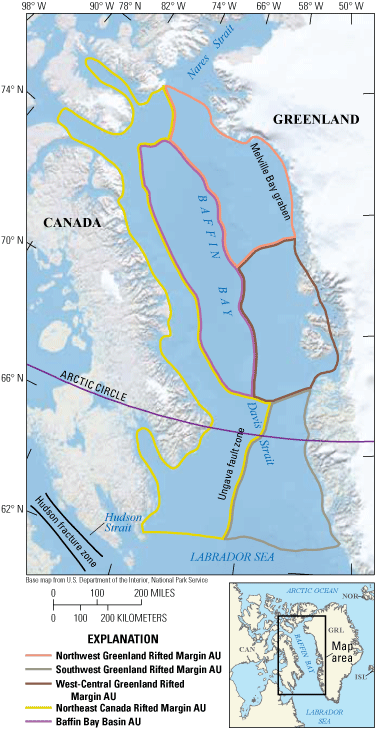
Maps showing the location of five conventional assessment units (AUs) in the West Greenland-East Canada Province.
Total Petroleum System and Assessment Units
The USGS defined the Mesozoic–Cenozoic Composite Total Petroleum System (TPS) in the West Greenland-East Canada Province (Schenk, 2011), which consists of potential hydrocarbon source rocks of Albian, Cenomanian–Turonian, Campanian, Paleocene–Eocene, and Miocene age (Bojesen-Koefoed and others, 1999; Christiansen and Bojesen-Koefoed, 2021) that may be present within both the western Greenland and eastern Canada rifted margins (Dam and others, 2020a). Within the TPS, five assessment units (AUs) were redefined from those of 2011 (Schenk, 2011) based on a compilation of new and existing information on the TPS elements of the western Greenland margin, the eastern Canada margin, and Baffin Bay (Harrison and others, 2011; Dam and others, 2020a, b; Dam and others, 2021; Dam and Sønderholm, 2021). The Geological Survey of Denmark and Greenland defined the Northwest Greenland Rifted Margin AU, Southwest Greenland Rifted Margin AU, and West-Central Greenland Rifted Margin AU (Dam and others, 2020a, b; Dam and others, 2021), and these three AUs were adopted for this assessment. The Northeast Canada Rifted Margin AU and the Baffin Bay Basin AU were defined in the compilation of geologic information by Harrison and others (2011) and were also adopted for this assessment (fig. 1).
Several hydrocarbon source rocks have been interpreted within the Mesozoic–Cenozoic Composite TPS based mainly on the geochemistry of oil seeps from the western Greenland margin (Christiansen and Bojesen-Koefoed, 2021). Peace and others (2018) suggested that Cretaceous source rocks may be spatially limited within grabens and the organic facies may be laterally varied. The potential source rocks within the thermal subsidence intervals may be more widespread, such as organic-rich Cenomanian mudstones. Modeling has indicated that several source rocks have reached the thermal generation windows for oil and gas (McGregor and others, (2014), and the deeper basins, such as the Melville Bay graben, may have several sources within the thermal gas generation window. Regionally, thermal maturation for oil and gas generation is modeled as occurring from the Eocene to the Miocene (McGregor and others, 2014).
Potential oil and gas reservoirs in the TPS have been summarized by Dam and Sønderholm (2021) as synrift and postrift. Reservoirs related to the first phase of rifting include alluvial fan to fluvial and deltaic channel sandstones, nearshore to deepwater lacustrine sandstones, and estuarine to marginal-marine sandstones. Reservoirs in the thermal subsidence phase are fluvial-deltaic channel sandstones, nearshore to shelf sandstones, and slope-channel to deep submarine fan sandstones. Reservoirs in the second rift phase are fluvial-deltaic channel sandstones to slope-channel and deep marine fan sandstones. Incised valleys have stacked fluvial and estuarine channel sandstones. Postrift reservoirs range from fluvial-deltaic to nearshore marine sandstones. Fractured volcanic rock may also form potential oil and gas reservoirs. Traps are complex along both margins because several phases of rifting, strike-slip faulting, and contractional deformation have modified original structures. Regional uplift and erosion related to mantle plumes may have resulted in loss of oil or gas. The assessment input data for five conventional AUs are summarized in table 1 and in Schenk (2025).
Table 1.
Key input data for five conventional assessment units in the West Greenland-East Canada Province.[Gray shading indicates not applicable. AU, assessment unit; MMBO, million barrels of oil; BCFG, billion cubic feet of gas]
Undiscovered Resources Summary
The USGS quantitatively assessed undiscovered conventional oil and gas resources in five AUs in the West Greenland-East Canada Province (table 2). The estimated mean resources are 7,769 million barrels of oil (MMBO), or 7.8 billion barrels of oil, with an F95–F5 range from 1,131 to 23,185 MMBO; 91,897 billion cubic feet of gas (BCFG), or 91.9 trillion cubic feet of gas, with an F95–F5 range from 18,018 to 236,136 BCFG; and 1,896 million barrels of natural gas liquids (MMBNGL), or 1.9 billion barrels, with an F95–F5 range from 368 to 4,885 MMBNGL. For the part of undiscovered resources north of the Arctic Circle in the West Greenland-East Canada Province, the allocated mean resources are 5,950 MMBO, or 6 billion barrels of oil, with an F95–F5 range from 839 to 18,001 MMBO; 69,632 BCFG, or 69.6 trillion cubic feet of gas, with an F95–F5 range from 13,331 to 180,875 BCFG; and 1,450 MMBNGL, or 1.4 billion barrels, with an F95–F5 range from 273 to 3,781 MMBNGL.
Table 2.
Results for five conventional assessment units in the West Greenland-East Canada Province, and an allocation of undiscovered resources north of the Arctic Circle.[Results shown are fully risked estimates. F95 represents a 95-percent chance of at least the amount tabulated; other fractiles are defined similarly. Gray shading indicates not applicable. MMBO, million barrels of oil; BCFG, billion cubic feet of gas; NGL, natural gas liquids; MMBNGL, million barrels of natural gas liquids]
For More Information
Assessment results are also available at the USGS Energy Resources Program website, https://www.usgs.gov/programs/energy-resources-program.
West Greenland-East Canada Province Assessment Team
Christopher J. Schenk, Tracey J. Mercier, Cheryl A. Woodall, Phuong A. Le, Andrea D. Cicero, Ronald M. Drake II, Geoffrey S. Ellis, Michael H. Gardner, Sarah E. Gelman, Jane S. Hearon, Benjamin G. Johnson, Jenny H. Lagesse, Heidi M. Leathers-Miller, Kristen R. Marra, Kira K. Timm, and Scott S. Young
References Cited
Bojesen-Koefoed, J.A., Christiansen, F.G., Nytoft, H.P., and Pedersen, A.K., 1999, Oil seepage onshore West Greenland—Evidence of multiple source rocks and oil mixing, in Fleet, A.J., and Boldy, S.A.R., eds., Petroleum geology of Northwest Europe—Proceedings of the 5th conference: Geological Society of London, p. 305–314, accessed January 18, 2024, at https://doi.org/10.1144/0050305.
Christiansen, F.G., and Bojesen-Koefoed, J.A., 2021, Inventory of onshore petroleum seeps and stains in Greenland—A web-based GIS model: GEUS [Geological Survey of Denmark and Greenland] Bulletin, v. 47, 20 p., accessed January 18, 2024, at https://doi.org/10.34194/geusb.v47.6519.
Dam, G., Bojesen-Koefoed, J.A., Gregersen, U., Mathiesen, A., Kristensen, L., Sønderholm, M., Willerslev, E., Hede, S.U., Varming, T., Brandt, M.P., and Kristensen, T.B., 2020a, Greenland resource assessment, assessment unit 1—Labrador Sea and Davis Strait project summary: Copenhagen, Denmark, Geological Survey of Denmark and Greenland, 20 p., accessed January 18, 2024, at https://greenland-resource-assessment.gl/assessment-units/au1-southern-west-greenland/.
Dam, G., Bojesen-Koefoed, J.A., Gregersen, U., Mathiesen, A., Kristensen, L., Sønderholm, M., Willerslev, E., Hede, S.U., Varming, T., Brandt, M.P., and Kristensen, T.B., 2020b, Greenland resource assessment, assessment unit 2—Baffin Bay project summary: Copenhagen, Denmark, Geological Survey of Denmark and Greenland, 18 p., accessed January 18, 2024, at https://greenland-resource-assessment.gl/assessment-units/au2b-baffin-bay/.
Dam, G., Bojesen-Koefoed, J.A., Gregersen, U., Mathiesen, A., Kristensen, L., Sønderholm, M., Willerslev, E., Varming, T., Brandt, M.P., and Kristensen, T.B., 2021, Greenland resource assessment, assessment unit 3—Disko West and Nuussuaq project summary: Copenhagen, Denmark, Geological Survey of Denmark and Greenland, 18 p., accessed January 18, 2024, at https://greenland-resource-assessment.gl/assessment-units/au3-central-west-greenland-2/.
Dam, G., and Sønderholm, M., 2021, Tectonostratigraphic evolution, paleogeography and main petroleum plays of the Nuussuaq Basin—An outcrop analogue for the Cretaceous–Paleogene rift basins offshore West Greenland: Marine and Petroleum Geology, v. 129, article 105047, 33 p., accessed January 18, 2024, at https://doi.org/10.1016/j.marpetgeo.2021.105047.
Funck, T., Gohl, K., Damm, V., and Heyde, I., 2012, Tectonic evolution of southern Baffin Bay and Davis Strait—Results from a seismic refraction transect between Canada and Greenland: Journal of Geophysical Research—Solid Earth, v. 117, no. B4, 24 p., accessed January 18, 2024, at https://doi.org/10.1029/2011JB009110.
Gregersen, U., Hopper, J.R., and Knutz, P.C., 2013, Basin seismic stratigraphy and aspects of prospectivity in the NE Baffin Bay, Northwest Greenland: Marine and Petroleum Geology, v. 46, p. 1–18, accessed January 18, 2024, at https://doi.org/10.1016/j.marpetgeo.2013.05.013.
Harrison, J.C., Brent, T.A., and Oakey, G.N., 2011, Baffin Fan and its inverted rift system of Arctic eastern Canada—Stratigraphy, tectonics and petroleum resource potential, in Spencer, A.M., Embry, A.F., Gautier, D.L., Stoupakova, A.V., and Sørensen, K., eds., Arctic Petroleum Geology: Geological Society of London Memoirs 35, p. 595–626, accessed January 18, 2024, at https://doi.org/10.1144/M35.40.
Jauer, C.D., Oakey, G.N., and Li, Q., 2019, Western Davis Strait, a volcanic transform margin with petroliferous features: Marine and Petroleum Geology, v. 107, p. 59–80, accessed January 18, 2024, at https://doi.org/10.1016/j.marpetgeo.2019.05.004.
Jess, S., Stephenson, R., and Brown, R., 2018, Evolution of the central West Greenland margin and the Nuussuaq Basin—Localized basin uplift along a stable continental margin proposed from thermochronological data: Basin Research, v. 30, no. 6, p. 1230–1246, accessed January 18, 2024, at https://doi.org/10.1111/bre.12301.
Knutz, P.C., Gregersen, U., Harrison, C., Brent, T.A., Hopper, J.R., and Nøhr-Hansen, H., 2022, Baffin Bay composite tectono-sedimentary element, in Drachev, S.S., Brekke, H., Henriksen, E., and Moore, T., eds., Sedimentary successions of the Arctic region and their hydrocarbon prospectivity: Geological Society of London Memoirs 57, 12 p., accessed January 18, 2024, at https://doi.org/10.1144/M57-2016-7.
Larsen, L.M., Heaman, L.M., Creaser, R.A., Duncan, R.A., Frei, R., and Hutchison, M., 2009, Tectonomagmatic events during stretching and basin formation in the Labrador Sea and the Davis Strait—Evidence from age and composition of Mesozoic to Palaeogene dyke swarms in West Greenland: Journal of the Geological Society [of London], v. 166, no. 6, p. 999–1012, accessed January 18, 2024, at https://doi.org/10.1144/0016-76492009-038.
McGregor, E.D., Nielsen, S.B., and Stephenson, R.A., 2014, Basin evolution in the Davis Strait area (West Greenland and conjugate East Baffin/Labrador passive margins) from thermostratigraphic and subsidence modelling of well data—Implications for tectonic evolution and petroleum systems: Bulletin of Canadian Petroleum Geology, v. 62, no. 4, p. 311–329, accessed January 18, 2024, at https://doi.org/10.2113/gscpgbull.62.4.311.
Oakey, G.N., and Chalmers, J.A., 2012, A new model for the Paleogene motion of Greenland relative to North America—Plate reconstructions of the Davis Strait and Nares Strait regions between Canada and Greenland: Journal of Geophysical Research, v. 117, no. B10, 28 p., accessed January 18, 2024, at https://doi.org/10.1029/2011JB008942.
Peace, A., McCaffrey, K., Imber, J., Hunen, J. van, Hobbs, R., and Wilson, R., 2018, The role of pre-existing structures during rifting, continental breakup and transform system development, offshore West Greenland: Basin Research, v. 30, no. 3, p. 373–394, accessed January 18, 2024, at https://doi.org/10.1111/bre.12257.
Schenk, C.J., 2011, Geology and petroleum potential of the West Greenland-East Canada Province, in Spencer, A.M., Embry, A.F., Gautier, D.L., Stoupakova, A.V., and Sørensen, K., eds., Arctic Petroleum Geology: Geological Society of London Memoirs 35, p. 627–645, accessed January 18, 2024, at https://doi.org/10.1144/M35.41.
Schenk, C.J., 2025, USGS National and Global Oil and Gas Assessment Project—West Greenland-East Canada Province—Assessment unit boundaries, assessment input tables, and fact sheet data tables: U.S. Geological Survey data release, https://doi.org/10.5066/P1VFG7YQ.
Disclaimers
Any use of trade, firm, or product names is for descriptive purposes only and does not imply endorsement by the U.S. Government.
Although this information product, for the most part, is in the public domain, it also may contain copyrighted materials as noted in the text. Permission to reproduce copyrighted items must be secured from the copyright owner.
Suggested Citation
Schenk, C.J., Mercier, T.J., Woodall, C.A., Le, P.A., Cicero, A.D., Drake, R.M., II, Ellis, G.S., Gardner, M.H., Gelman, S.E., Hearon, J.S., Johnson, B.G., Lagesse, J.H., Leathers-Miller, H.M., Marra, K.R., Timm, K.K., and Young, S.S., 2025, Assessment of undiscovered conventional oil and gas resources of the West Greenland-East Canada Province, 2023: U.S. Geological Survey Fact Sheet 2025–3016, 4 p., https://doi.org/10.3133/fs20253016.
ISSN: 2327-6932 (online)
Study Area
| Publication type | Report |
|---|---|
| Publication Subtype | USGS Numbered Series |
| Title | Assessment of undiscovered conventional oil and gas resources of the West Greenland-East Canada Province, 2023 |
| Series title | Fact Sheet |
| Series number | 2025-3016 |
| DOI | 10.3133/fs20253016 |
| Publication Date | July 09, 2025 |
| Year Published | 2025 |
| Language | English |
| Publisher | U.S. Geological Survey |
| Publisher location | Reston VA |
| Contributing office(s) | Central Energy Resources Science Center |
| Description | Report: 4 p.; Data Release |
| Country | Canada, Greenland |
| Other Geospatial | Baffin Bay |
| Online Only (Y/N) | Y |