

U.S. Geological Survey Global Seabed Mineral Resources
Links
- Document: Report (4.83 MB pdf) , HTML , XML
- Version History: Version History (680 KB txt)
- NGMDB Index Page: National Geologic Map Database Index Page (html)
- Download citation as: RIS | Dublin Core
The U.S. Geological Survey (USGS) provides science and data on seabed mineral resources and ecosystems, as well as any potential hazards associated with extraction. The Nation relies on minerals for infrastructure, technology, manufacturing, and energy production. Critical minerals (USGS, 2022a) are essential to the economic and national security of the United States and have a supply chain vulnerable to disruption.
For decades, USGS scientific innovation has contributed to the delineation of seabed mineral resources, the mechanisms of seabed mineral formation, and the environmental impacts of resource extraction. Since 1962, the USGS has also led scientific inquiries into the potential for deep sea mining. By providing impartial science on seabed minerals and their environmental setting in the deep oceans, the USGS enables decision-makers to evaluate the best practices for mineral resource development.
What Is the Role of the USGS in Understanding Seabed Minerals?
In many regions of the global ocean, limited data are available regarding the abundance, composition, environmental setting, and associated ecology of seabed minerals. The USGS provides cutting-edge, impartial data on seabed minerals by creating prospective maps of the places where these minerals may occur, investigating the processes that lead to specific enrichments within these minerals, and studying the physical and chemical implications of potential commercial extraction. The USGS also conducts multidisciplinary studies of the marine and seabed environments where these minerals exist. Such investigations provide data and insights that are essential for decision-makers and the public to understand and make informed decisions regarding potential resource extraction.
The USGS provides the Nation with expertise in many aspects of global seabed minerals through a collaboration of three Mission Areas:
-
• The Coastal and Marine Hazards and Resources Program in the Natural Hazards Mission Area (https://www.usgs.gov/programs/cmhrp) leads Federal scientific work on seabed minerals, which has included research into polymetallic nodules in the Clarion-Clipperton Zone, Cook Islands, and elsewhere; cobalt-rich ferromanganese crusts throughout the central and western Pacific Ocean, the Arctic Ocean and the Atlantic Ocean; and polymetallic sulfides in many locations globally, including most recently on an interagency research expedition to the Escanaba Trough off the shore of northern California (Pearsall, 2022).
-
• The Land Management Research Program in the Ecosystems Mission Area (https://www.usgs.gov/programs/land-management-research-program) characterizes seabed and water-column ecosystems and studies the potential environmental effects of disturbing habitats or ecosystems, including recent work on the Blake Plateau off the shore of South Carolina (USGS, 2024).
-
• The Mineral Resources Program in the Energy and Minerals Mission Area (https://www.usgs.gov/programs/mineral-resources-program) contributes expertise in natural resources, mineral lifecycles, and mineral supply chains. The Program’s National Mineral Information Center (https://www.usgs.gov/centers/national-minerals-information-center) tracks mineral commodities, including any extracted seabed minerals.
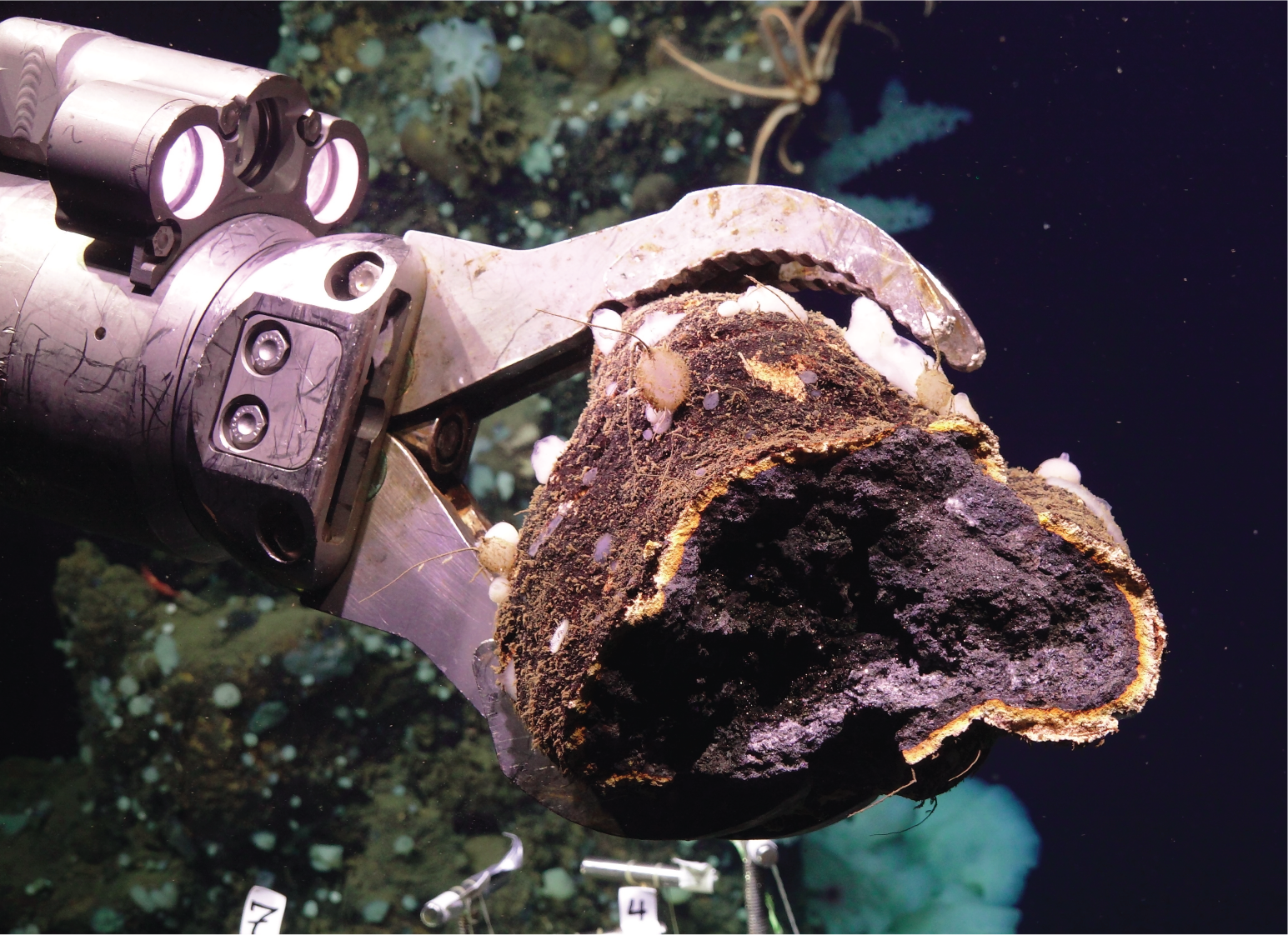
Remotely operated vehicle collects a sulfide mineral sample from Escanaba Trough.
USGS activities focused on seabed mineral studies complement the Survey’s work on land-based minerals and mineral supply chains. USGS data collection and analysis are used to evaluate and identify minerals that are critical to the economic and national security interests of the United States. The USGS also analyzes mineral markets and provides statistics on mineral commodities in all sectors of the U.S. economy, including analysis in support of national security.
In addition to collaboration within the three Mission Areas, the USGS collaborates on targeted studies of seabed minerals and associated ecosystems with the Bureau of Ocean Energy Management, which has regulatory authority for mineral extraction on the U.S. Outer Continental Shelf, and the National Oceanic and Atmospheric Administration, which has regulatory authority for U.S. activities related to mineral extraction on the high seas. Such studies provide crucial data that inform the regulatory decisions of other agencies.
Which Minerals Are Found in Seabed Environments?
Minerals can be found in every ocean basin, from the coastal zone to the deep ocean (USGS, 2022b). In the deep ocean, exploration is ongoing for polymetallic nodules, polymetallic sulfides, and cobalt-rich ferromanganese crusts. These minerals are considered a potential future source of many elements, including some elements that are designated as critical minerals (table 1). Critical minerals that are abundant in sea-floor deposits include nickel, cobalt, and manganese. These minerals are crucial components in stainless steel, superalloys, and batteries. The rare earth elements and yttrium, often abbreviated as REY, are a group of 17 elements. Two of these, neodymium and dysprosium, are used in permanent magnets and lasers.
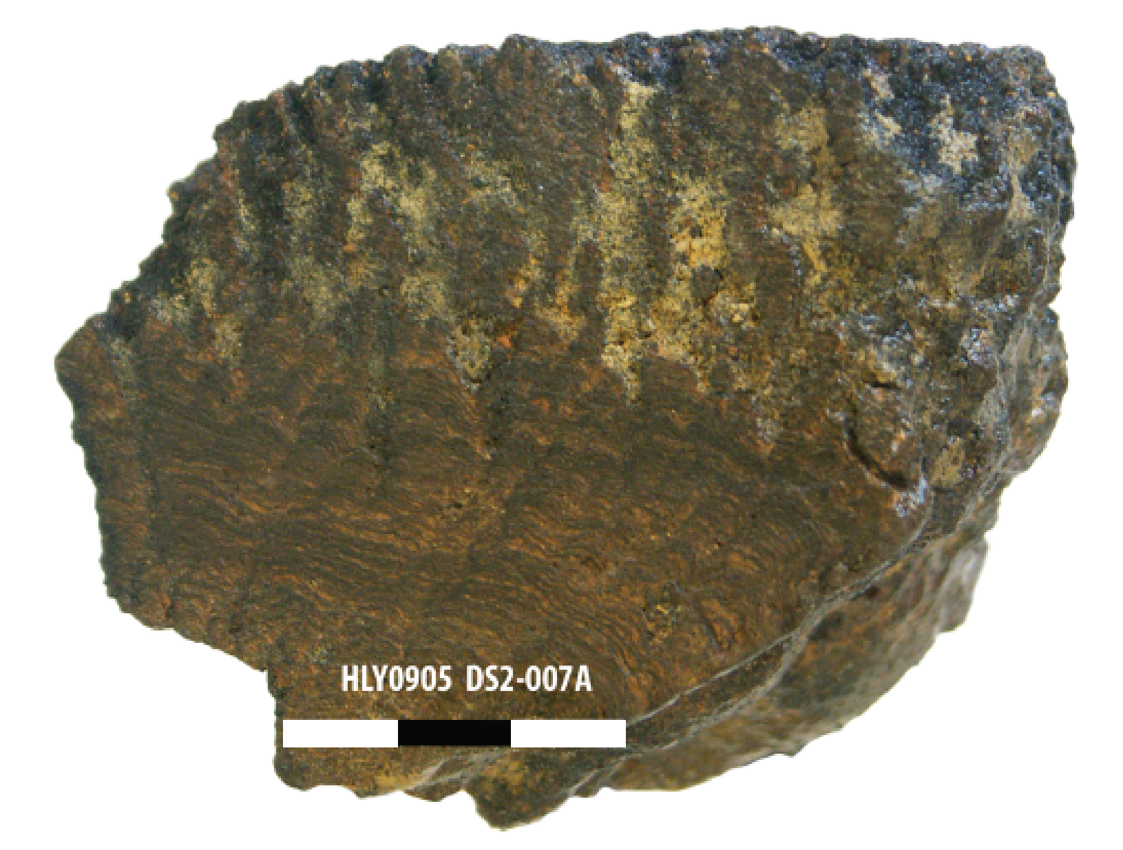
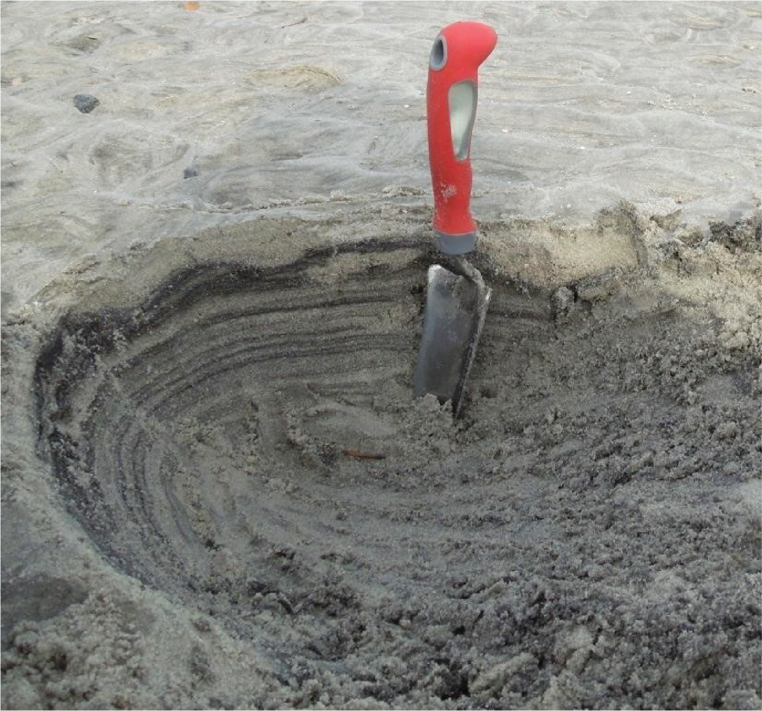
Polymetallic nodules.
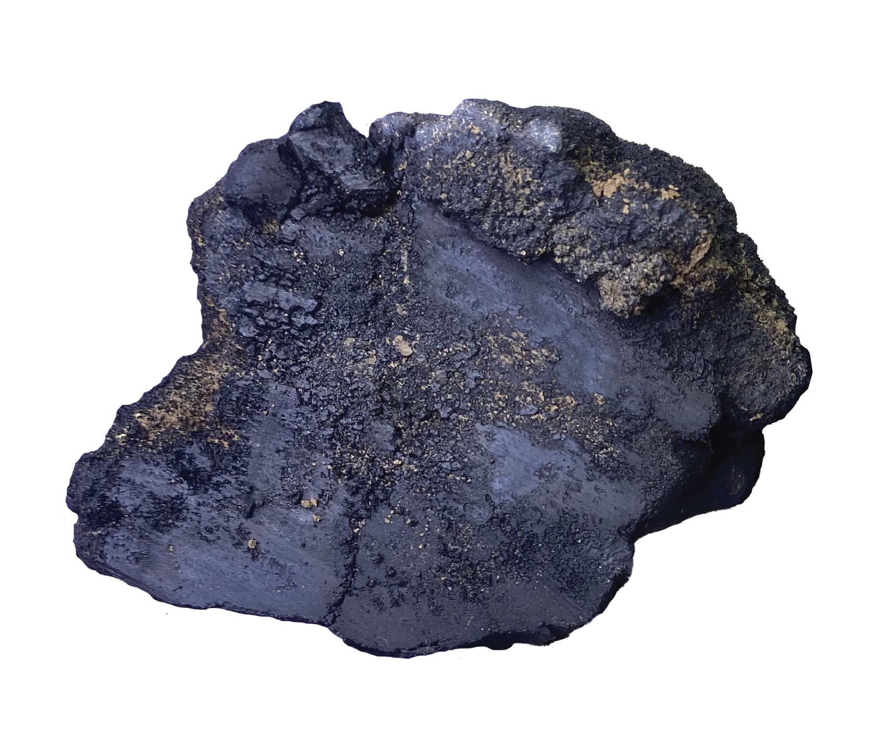
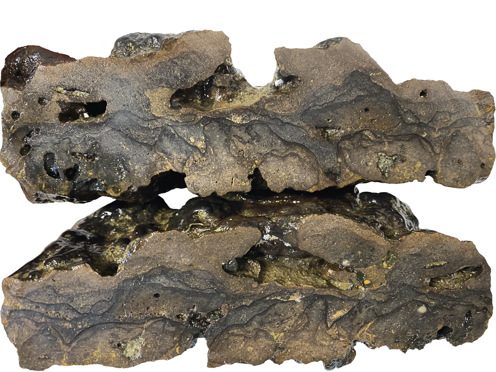
Polymetallic sulfide.
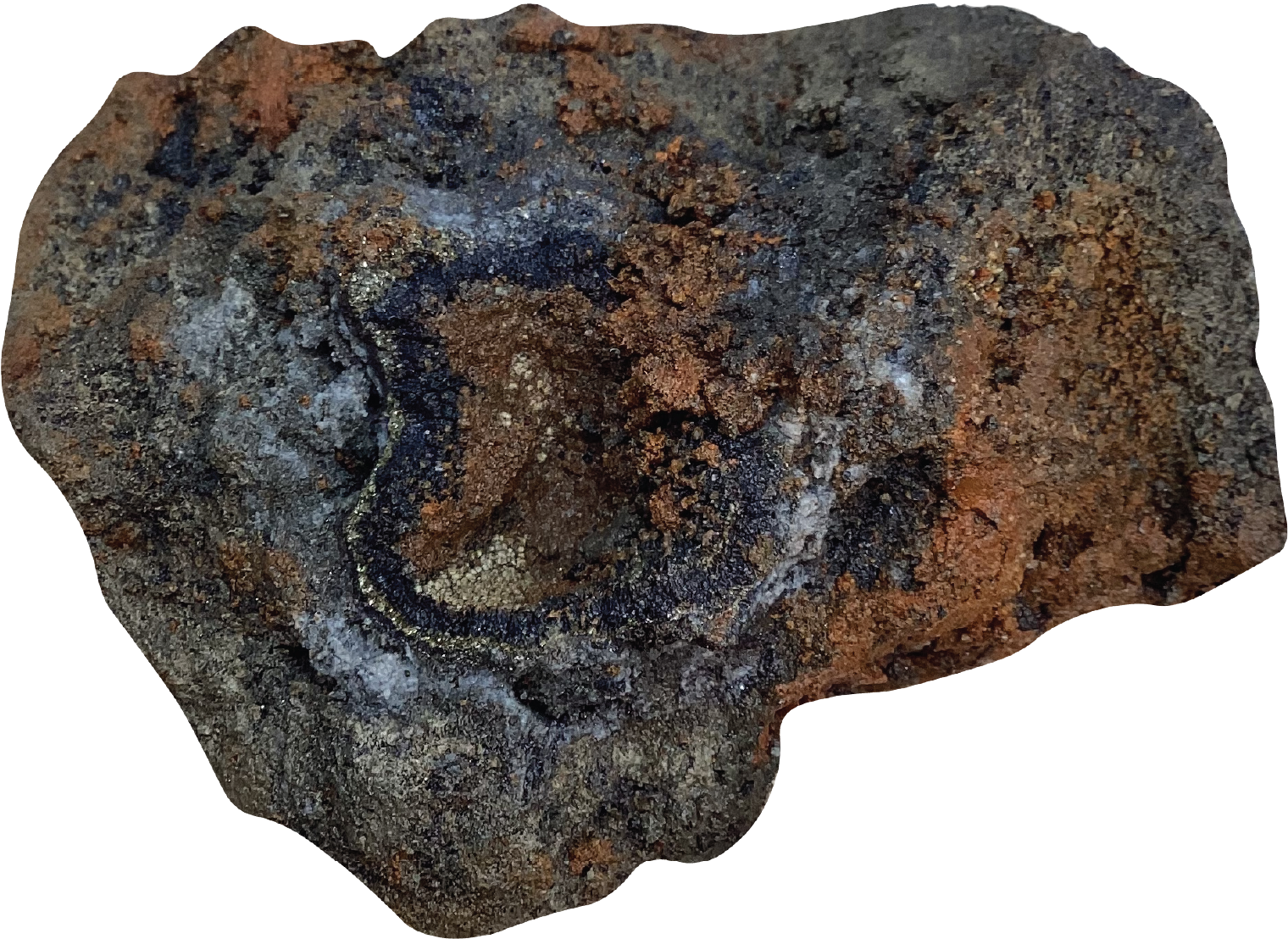
Cobalt-rich ferromanganese crust.
Phosphorite.
Heavy mineral sands.
Table 1.
Elements found in seabed minerals.[The term “potential byproducts” indicates elements that are not a main product of a potential mining operation but could possibly be produced in addition to the main products. REY, rare earth elements including yttrium; —, not applicable]
Included in the 2022 list of critical minerals (USGS, 2022a).
Where Are Seabed Minerals Found?
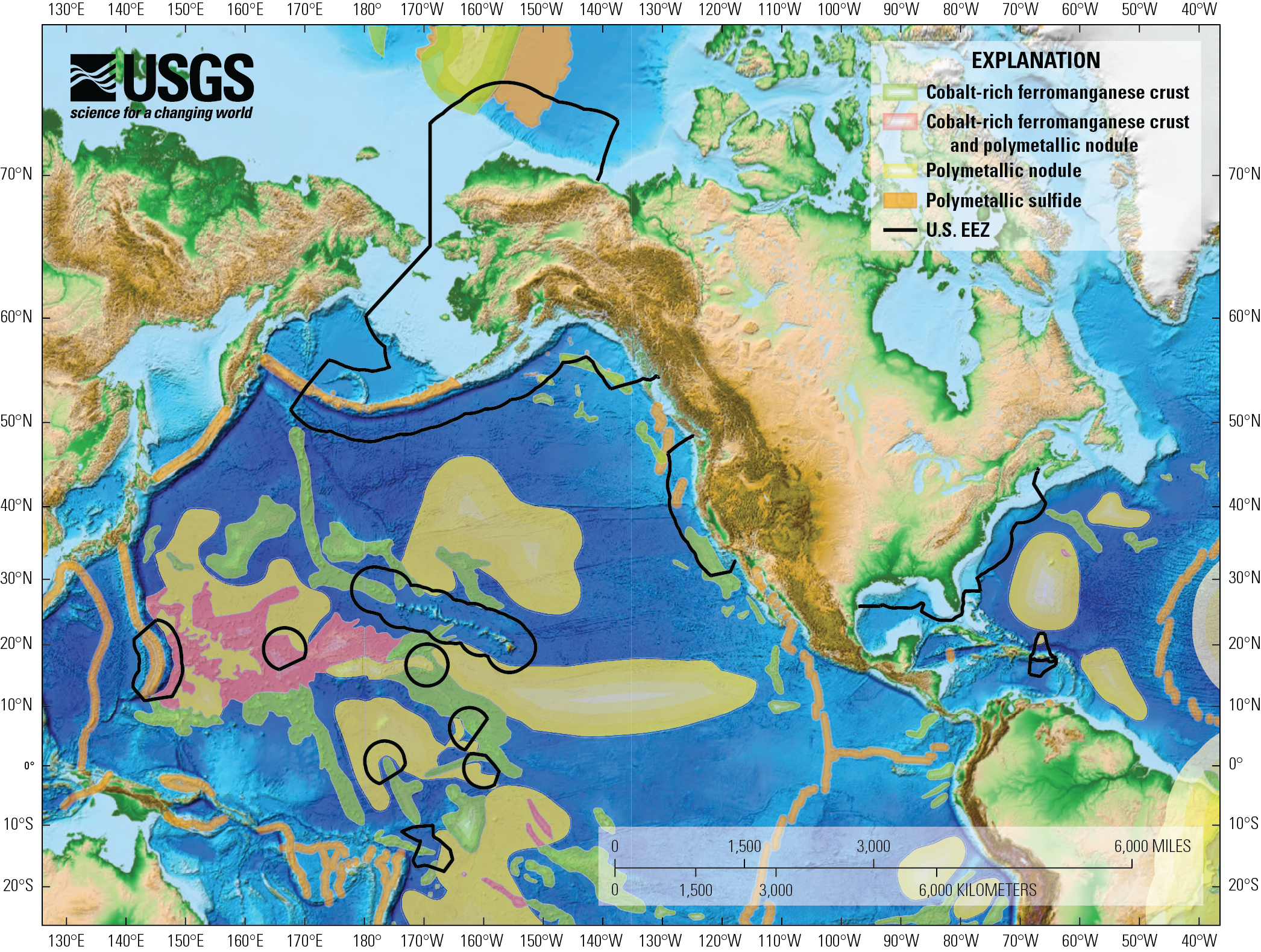
Global seabed mineral prospective regions, including those that occur within the U.S. Exclusive Economic Zone (U.S. EEZ). More information on these regions can be found in Mizell and others (2022) and Gartman and others (2022).
Seabed minerals occur in every ocean basin, including within the U.S. Exclusive Economic Zone (Hein and others, 2005), which is larger than the land area of the United States, as well as the Extended Continental Shelf (U.S. Department of State, 2023). However, as of 2025, only a few of these locations have sufficient data to determine whether they have deposits, defined as mineral concentrations that could be viable for commercial production.
The map shows prospective regions, or regions where minerals may occur based on geological and oceanographic criteria, for polymetallic nodules and cobalt-rich ferromanganese crusts. The map also outlines mid-ocean ridges and back arc basins, which, along with volcanic arcs, are regions where hydrothermal vents form. Under certain conditions, hydrothermal vents can form polymetallic sulfide deposits. As of 2025, there are only a handful of locations where enough data have been collected on the grade and tonnage of these minerals for the term “deposit” to be used with confidence.
Selected References
Burton, J., 2022, U.S. Geological Survey releases 2022 list of critical minerals: U.S. Geological Survey news release, accessed March 12, 2025, at https://www.usgs.gov/news/national-news-release/us-geological-survey-releases-2022-list-critical-minerals.
Gartman, A., Mizell, K., and Kreiner, D.C., 2022, Marine minerals in Alaska—A review of coastal and deep-ocean regions: U.S. Geological Survey Professional Paper 1870, 46 p., accessed March 12, 2025, at https://doi.org/10.3133/pp1870.
Hein, J.R., McIntyre, B.R., and Piper, D.Z., 2005, Marine mineral resources of Pacific Islands—A review of the Exclusive Economic Zones of islands of U.S. affiliation, excluding the State of Hawaii: U.S. Geological Survey Circular 1286, 62 p., accessed March 12, 2025, at https://doi.org/10.3133/cir1286.
Mizell, K., Hein, J.R., Au, M., Gartman, A., 2022, Estimates of metals contained in abyssal manganese nodules and ferromanganese crusts in the global ocean based on regional variations and genetic types of nodules, in Sharma, R., ed., Perspectives on deep-sea mining: Cham, Switzerland, Springer, p. 53–80, https://doi.org/10.1007/978-3-030-87982-2_3
Pearsall, P.L., 2022, USGS leads research expedition to deep-sea Escanaba Trough: U.S. Geological Survey web page, accessed March 12, 2025, at https://www.usgs.gov/centers/pcmsc/news/usgs-leads-research-expedition-deep-sea-escanaba-trough.
U.S. Department of State, 2023, The outer limits of the extended continental shelf of the United States of America—Executive summary (revised 2025): Washington, D.C., U.S. Department of State, 100 p., accessed March 12, 2025, at https://www.state.gov/wp-content/uploads/2025/02/ECS_Executive_Summary.pdf.
U.S. Geological Survey [USGS], 2022a, 2022 final list of critical minerals [notice]: Federal Register vol. 87, no. 37, p. 10381–10382, accessed March 12, 2025, at https://www.federalregister.gov/documents/2022/02/24/2022-04027/2022-final-list-of-critical-minerals.
U.S. Geological Survey [USGS], 2022b, Global seabed mineral resources: U.S. Geological Survey web page, accessed March 27, 2025, at https://www.usgs.gov/centers/pcmsc/science/global-marine-mineral-resources.
U.S. Geological Survey [USGS], 2024, Environmental impacts following the 1970 testing of seabed mining equipment on the Black Plateau—Quantification of benthic communities across disturbance gradients: U.S. Geological Survey web page, accessed March 12, 2025, at https://www.usgs.gov/centers/wetland-and-aquatic-research-center/science/environmental-impacts-following-1970-testing.
U.S. Geological Survey [USGS], 2025, Extended continental shelf: U.S. Geological Survey web site, accessed March 12, 2025, at https://www.usgs.gov/special-topics/deep-sea-exploration%2C-mapping-and-characterization/science/extended-continental.
Disclaimers
Any use of trade, firm, or product names is for descriptive purposes only and does not imply endorsement by the U.S. Government.
Although this information product, for the most part, is in the public domain, it also may contain copyrighted materials as noted in the text. Permission to reproduce copyrighted items must be secured from the copyright owner.
Suggested Citation
U.S. Geological Survey, 2025, U.S. Geological Survey global seabed mineral resources (ver. 1.1, April 8, 2025): U.S. Geological Survey Fact Sheet 2025–3017, 4 p., https://doi.org/10.3133/fs20253017.
ISSN: 2327-6932 (online)
ISSN: 2327-6916 (print)
| Publication type | Report |
|---|---|
| Publication Subtype | USGS Numbered Series |
| Title | U.S. Geological Survey global seabed mineral resources |
| Series title | Fact Sheet |
| Series number | 2025-3017 |
| DOI | 10.3133/fs20253017 |
| Edition | Version 1.0: April 1, 2025; Version 1.1: April 8, 2025 |
| Publication Date | April 01, 2025 |
| Year Published | 2025 |
| Language | English |
| Publisher | U.S. Geological Survey |
| Publisher location | Reston, VA |
| Contributing office(s) | Pacific Coastal and Marine Science Center |
| Description | 4 p. |
| Online Only (Y/N) | N |
| Additional Online Files (Y/N) | N |