

The 3D Elevation Program—Supporting Rhode Island’s Economy
Links
- Document: Report (628 KB pdf) , HTML , XML
- Download citation as: RIS | Dublin Core
Introduction
High-resolution elevation data are critical to applications of landscape modeling and planning, both of which have a significant effect on Rhode Island’s economy. In these and other enterprises, program managers, while aiming to strike a balance between accuracy and cost, strive to obtain the best available elevation data to help them address a range of issues. Programs focused on climate change, environmental management, transportation design and asset management, aviation navigation and safety, riverine ecosystem management, wildlife habitat characterization and management, shellfish aquaculture, and the management and mapping of forests, parks and recreation areas, soils, wetlands, and impervious surfaces are also among the critical applications that meet the State’s management needs and depend on light detection and ranging (lidar) data that provide a highly detailed three-dimensional (3D) model of the Earth’s surface and aboveground features.
The 3D Elevation Program (3DEP; refer to sidebar) is managed by the U.S. Geological Survey (USGS) in partnership with Federal, State, Tribal, U.S. territorial, and local agencies to acquire consistent lidar coverage at quality level 2 or better (table 1) to meet the many needs of the Nation and Rhode Island. The status of available and in-progress 3DEP baseline lidar data in Rhode Island is shown in figure 1. 3DEP baseline lidar data include quality level 2 or better, 1-meter or better digital elevation models, and lidar point clouds, and must meet the Lidar Base Specification version 1.2 (https://www.usgs.gov/3dep/lidarspec) or newer requirements. The National Enhanced Elevation Assessment (Dewberry, 2012) identified user requirements and conservatively estimated that availability of lidar data would result in at least $178,560 in new benefits annually to the State. The top 10 Rhode Island business uses for 3D elevation data, which are based on the estimated annual conservative benefits of 3DEP, are shown in table 2.
Table 1.
Data quality levels, pulse spacing, and pulse density. Quality level 2 or better lidar data meet 3DEP requirements.[Specifications for quality level 0 (QL0) are from Heidemann (2012, p. 3 and table 1); for quality levels 1 and 2, specifications are from Sugarbaker and others (2014, table 1). In the quality level column, QL0 represents the highest level of quality. RMSEz, root mean square error in the elevation (z) dimension; cm, centimeter; m, meter; pls/m2, first return pulses per square meter; ≤, less than or equal to; ≥, greater than or equal to]
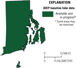
Map of Rhode Island showing status of 3D Elevation Program (3DEP) baseline lidar data as of December 2024. Visit https://usgs.gov/NationalMap/LidarExplorer to find and download currently available data.
Table 2.
Conservative benefits estimates for the top 10 Rhode Island business uses of the proposed 3DEP data identified in the National Enhanced Elevation Assessment (Dewberry, 2012).Status of 3DEP in Rhode Island
Rhode Island completed statewide quality level 3 lidar coverage in the spring of 2011 through the Northeast Lidar Project (USGS on Implementation of the American Recovery and Reinvestment Act, Larsen, 2009). Between 2014 and 2018, the National Oceanic and Atmospheric Administration, U.S. Army Corps of Engineers, and USGS acquired quality level 2 lidar data for all coastal areas.
The State of Rhode Island, USGS, and the Natural Resources Conservation Service of the U.S. Department of Agriculture identified business uses and mission critical activities that can benefit from statewide lidar elevation data being updated to quality level 1. As a result, statewide quality level 1 lidar was collected in the spring of 2022. The beach area lidar collection was timed to be within 120 minutes of the predicted mean low tide to measure the elevation of the subaerial beach (the part of the beach uncovered by water) as far into the intertidal zone as possible.
Flood Risk Management
Lidar data provide high-quality terrain information as input for more accurate and more cost-effective hydrologic and hydraulic modeling for flood studies, retention-dam design, dam breach studies, and stormwater management and engineering. This information can be used to identify vulnerable properties within a flood plain, facilitate better flood-plain management decisions, and educate the public on flood risk zones by providing dynamic 3D models to show the potential impact of flooding from major storm events.
Coastal Zone Management
Even before Hurricane Sandy in 2012, coastal Rhode Island communities were engaged in detailed vulnerability planning exercises pertaining to natural resources, transportation infrastructure, buildings, and cultural assets that are at risk from sea-level rise and storm surge. This modeling requires up-to-date high-resolution topographic and bathymetric elevation data to keep current with geomorphological changes along the shoreline that are predicted to occur more frequently with storms of increasing intensity, periodicity, and duration.
Infrastructure and Construction Management
When lidar data are readily available, the need for traditional topographic land surveys, including infrastructure and construction site planning and estimating, is minimized. Reducing the time required for project planning provides a cost saving to the public. Lidar data can be used for preliminary highway alignment and design, estimating earthwork quantities, evaluating existing roadway conditions, and identifying needed safety projects. High-quality elevation data help to improve compliance with building and environmental regulations, enable the evaluation of numerous potential sites with a sufficient level of detail for decision making, provide input to hydraulic modeling for the design of structures (bridges and culverts) to accommodate runoff and flooding from large rain events, and can be integrated with other data, such as geologic, engineering, environmental, and cultural data (fig. 2) to expedite project review and reduce cost.
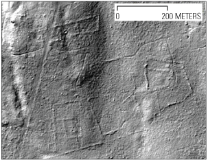
Bare-earth lidar image showing stone walls, old buildings, roads, and other pieces of long-forgotten history, in Weetamoo Woods in Tiverton, Rhode Island. Image courtesy of Katharine Johnson, North Carolina State University.
Urban and Regional Planning
Lidar data enable municipalities to make comprehensive plans for land development and zoning, develop parcel slope models for subdivision runoff, perform climate change adaptation planning, and conduct viewshed analyses for proposed cellular structures. In addition, lidar data enable municipal mapping of building footprints and impervious surfaces and rectification of imagery for production of digital orthophotos. Lidar data also enable municipalities to use 3D models to design flood evacuation route plans and to conduct bare-earth and tree-crown analysis in parks to improve visitors' experience.
3D Elevation Program (3DEP)
The 3D Elevation Program is managed by the U.S. Geological Survey (USGS) on behalf of the community of Federal, State, Tribal, local, and other partners and users of elevation data. In response to growing needs for high-quality elevation data, the goal of 3DEP is to complete acquisition of nationwide light detection and ranging (lidar) data (interferometric synthetic aperture radar [IfSAR] data in Alaska) to provide the first-ever national baseline of consistent, high-resolution topographic elevation data—both bare-earth digital elevation models and 3D point clouds.
Benefits
-
• Economies of scale by acquiring data for larger areas.
-
• Predictable and flexible Federal investments that can reduce costs and allow better planning.
-
• Consistent national coverage that provides data for applications that span project, jurisdictional, and watershed boundaries.
-
• Simplified data acquisition that provides contracts, project management, quality assurance, and published data specifications.
-
• National benefits of $690 million per year, conservatively, with the potential to generate $13 billion per year in additional benefits through applications that span the economy (Dewberry, 2012).
High-Quality Data and Products
3DEP lidar data provide coverage with a minimum of two points per square meter and a vertical error not to exceed 10 centimeters, measured as root mean square error in the elevation (z) dimension (RMSEz) (table 1). 3DEP baseline lidar data products include all data points collected (point clouds) and bare-earth digital elevation models with a 1-meter or better resolution. The USGS integrates the elevation data into The National Map. Data are available free of charge and without use restrictions. To download 3DEP products visit https://apps.nationalmap.gov/downloader/.
Ways to Participate
Participation in 3DEP is open to Federal, State, Tribal, U.S. territorial, and local government partners, as well as private sector partners, and offers the option to acquire even higher quality data. Partners may contribute funds toward projects managed by the USGS, or they may receive cooperative funds to manage their own projects. An annual Data Collaboration Announcement is the mechanism used to establish partner agreements. Organizations and the private sector may contribute existing data that meet 3DEP requirements. For more information refer to the 3DEP website at https://usgs.gov/3DEP/collaborate.
References Cited
Dewberry, 2012, National Enhanced Elevation Assessment final report (revised March 29, 2012): Fairfax, Va., Dewberry, 84 p. plus appendixes, accessed June 15, 2022 at https://www.dewberry.com/services/ geospatial/national-enhanced-elevation-assessment.
Heidemann, H.K., 2012, Lidar base specification (ver. 1.2, November 2014): U.S. Geological Survey Techniques and Methods, book 11, chap. B4, 67 p. with appendixes, accessed August 5, 2022, at https://doi.org/10.3133/tm11B4.
Larsen, M.C., 2009, USGS on Implementation of the American Recovery and Reinvestment Act of 2009 (PL 111–05): U.S. Geological Survey, accessed June 15, 2022, at https://www.usgs.gov/index.php/ congressional/statement-matthew-c-larsen-associate-director-water.
Sugarbaker, L.J., Constance, E.W., Heidemann, H.K., Jason, A.L., Lukas, V., Saghy, D.L., and Stoker, J.M., 2014, The 3D Elevation Program initiative—A call for action: U.S. Geological Survey Circular 1399, 35 p., accessed June 15, 2022, at https://doi.org/https://doi.org/10.3133/cir1399.
For Further Information:
Director, National Geospatial Program
U.S. Geological Survey, MS 511
12201 Sunrise Valley Drive
Reston, VA 20192
Email: 3DEP@usgs.gov
USGS National Map Liaison: Adam Benthem;
Email: abenthem@usgs.gov
Disclaimers
Any use of trade, firm, or product names is for descriptive purposes only and does not imply endorsement by the U.S. Government.
Although this information product, for the most part, is in the public domain, it also may contain copyrighted materials as noted in the text. Permission to reproduce copyrighted items must be secured from the copyright owner.
Suggested Citation
Walters, D., 2025, The 3D Elevation Program—Supporting Rhode Island’s economy: U.S. Geological Survey Fact Sheet 2025–3018, 2 p., https://doi.org/10.3133/fs20253018.
ISSN: 2327-6932 (online)
Study Area
| Publication type | Report |
|---|---|
| Publication Subtype | USGS Numbered Series |
| Title | The 3D Elevation Program—Supporting Rhode Island’s economy |
| Series title | Fact Sheet |
| Series number | 2025-3018 |
| DOI | 10.3133/fs20253018 |
| Publication Date | April 08, 2025 |
| Year Published | 2025 |
| Language | English |
| Publisher | U.S. Geological Survey |
| Publisher location | Reston, VA |
| Contributing office(s) | National Geospatial Program |
| Description | 2 p. |
| Country | United States |
| State | Rhode Island |
| Online Only (Y/N) | Y |
| Additional Online Files (Y/N) | N |