

The Long Island Sound and Watershed Metadata Map Application
Links
- Document: Report (8.16 MB pdf) , HTML , XML
- Download citation as: RIS | Dublin Core
Abstract
The Long Island Sound and its watershed encompass an area of about 17,000 square miles and include the Connecticut, Housatonic, and Thames Rivers, which all drain to the sound. Dozens of organizations from government agencies, nonprofits, and Tribal Nations have developed projects and monitoring programs to analyze and protect the water resources of the watershed and sound. The abundance of data and lack of an existing searchable index require a centralized metadata repository to allow users to find water resources data more efficiently. The U.S. Geological Survey, in cooperation with the U.S. Environmental Protection Agency and the Long Island Sound Study, has created an interactive map application to visualize and search for metadata information across organizations working to monitor and protect the Long Island Sound.
Plain Language Summary
The Long Island Sound watershed is home to nearly 9 million people in parts of Connecticut, Massachusetts, New Hampshire, New York, Rhode Island, Vermont, and Canada. Government agencies, nonprofits, and Tribal Nations have overseen numerous projects to monitor and protect the water resources of this watershed and the sound. Although there is an abundance of data, there is no easy way to search them or a central place to manage this information. To help, the U.S. Geological Survey, the U.S. Environmental Protection Agency, and the Long Island Sound Study have created an interactive map to help users find and understand data about the water resources of the Long Island Sound and its watershed.
The Long Island Sound Watershed
The Long Island Sound is a tidal estuary in the northeastern United States. It has an area of 1,194 square miles, drains about 17,000 square miles, ranges from freshwater to saltwater, and encompasses almost 600 miles of shoreline (Long Island Sound Study, 2024). Several major rivers contribute to the sound, including the Connecticut, Housatonic, and Thames Rivers. These rivers and their tributaries make up most of the Long Island Sound watershed, or the area of land from which water drains into the sound. The watershed spans parts of Connecticut, Massachusetts, New Hampshire, New York, Rhode Island, and Vermont in the United States and Quebec in Canada that are populated by nearly 9 million people (Long Island Sound Study, 2024; Parker, 2024). Land use in the Long Island Sound watershed includes urban areas along the Connecticut River and the coast of the Long Island Sound and mostly forested and agricultural areas in western Massachusetts, New Hampshire, and Vermont (fig. 1). Land use can greatly affect the quality and quantity of stormwater runoff, groundwater recharge, flooding, and overall ecosystem health, making it an important factor within the watershed.
Past and current studies of the Long Island Sound and its watershed by Federal, State, Tribal Nation, academic, and community organizations include topics such as water quality, nutrient loading, fisheries, flora and fauna, groundwater supply and quantity, spatial coverages and land use, infrastructure, climate change, sediment and geology, flooding, forestry, and energy (Latimer and others, 2014). The goal of these efforts is to provide up-to-date science relevant to the Long Island Sound and its watershed.
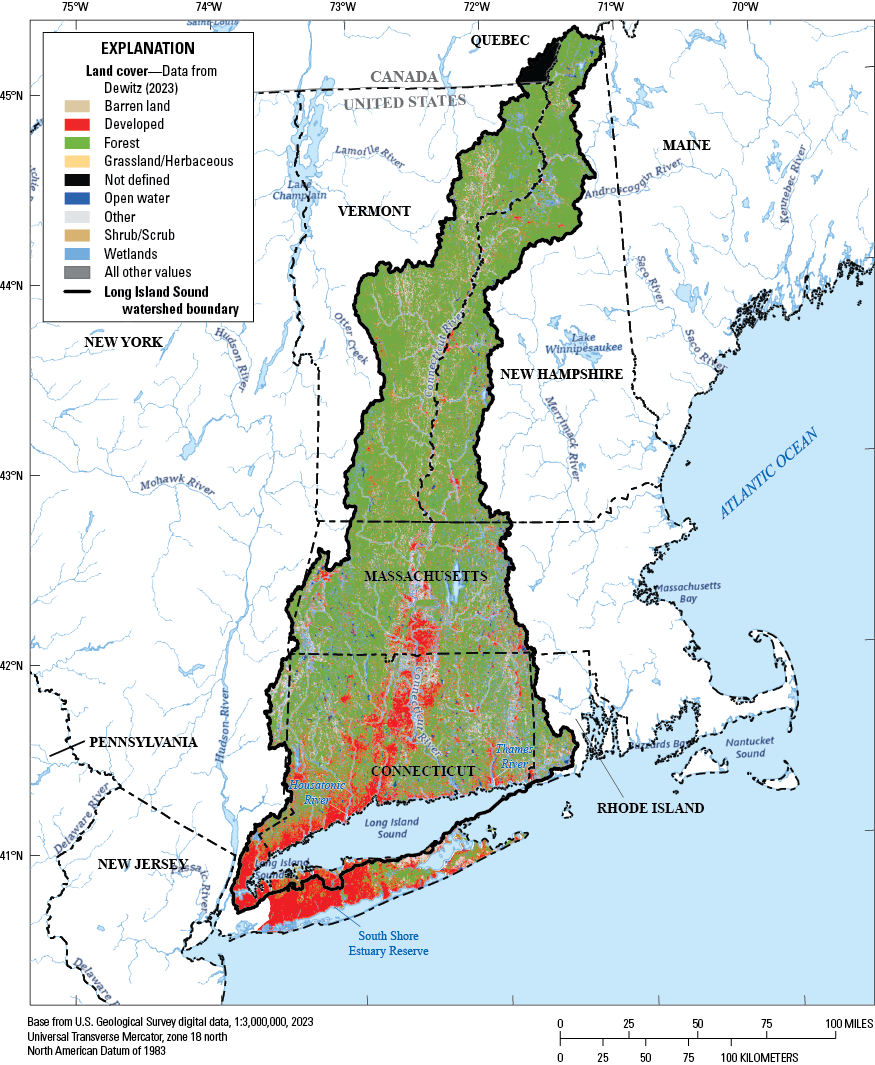
Map showing land cover in the Long Island Sound watershed, encompassing Connecticut, Massachusetts, New Hampshire, New York, Rhode Island, and Vermont in the United States and Quebec in Canada.
Map Application Purpose
The abundance of data produced from studying the Long Island Sound and its watershed across many disciplines prompted the U.S. Geological Survey (USGS) to work with the U.S. Environmental Protection Agency (EPA) and the Long Island Sound Study to compile information from various monitoring projects through an interactive online map-based application (fig. 2). Many States and other organizations conducting studies in the Long Island Sound watershed have publicly accessible data repositories (table 1); however, this information is spread across several databases. The spatial display of information in this application provides a single platform where the details of projects throughout the watershed can be accessed to promote collaboration, identify data gaps, reduce duplicated efforts, and allow for more efficient use of resources.
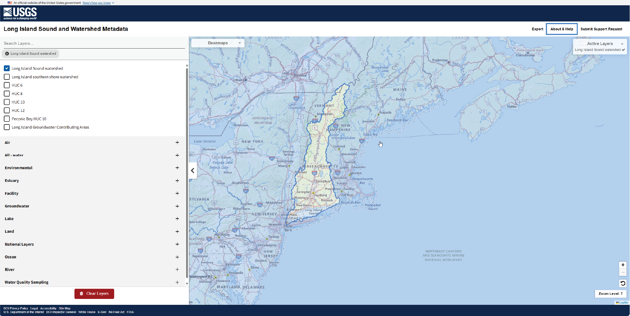
Screenshot showing the Long Island Sound and Watershed Metadata map application.
Table 1.
Sources of public metadata for the Long Island Sound watershed.[GIS, geographic information system]
| Public metadata source | Website address |
|---|---|
| Connecticut Department of Energy and Environmental Protection GIS Open Data website | https://deepmaps.ct.gov/ |
| Connecticut Environmental Conditions Online | https://maps.cteco.uconn.edu/ |
| MassGIS Massachusetts Bureau of Geographic Information | https://www.mass.gov/orgs/massgis-bureau-of-geographic-information |
| New Hampshire Department of Environmental Services Geodata Portal | https://nh-department-of-environmental-services-open-data-nhdes.hub.arcgis.com/ |
| New York State GIS Clearinghouse | https://data.gis.ny.gov/ |
| New York City Harbor Water Quality | https://data.cityofnewyork.us/Environment/Harbor-Water-Quality/5uug-f49n/about_data |
| Rhode Island GIS | https://www.rigis.org/ |
| Vermont Open Geodata Portal | https://geodata.vermont.gov/ |
| Water Quality Portal | https://www.waterqualitydata.us/ |
| U.S. Geological Survey ScienceBase | https://www.sciencebase.gov/catalog/ |
| Northeastern Regional Association of Coastal Ocean Observing Systems | http://www.neracoos.org/erddap/ |
The Long Island Sound and Watershed Metadata Map Application
The Long Island Sound and Watershed Metadata map application (U.S. Geological Survey, 2024; https://apps.usgs.gov/liswmetadata/) does not host data or maintain data repositories. Instead, it compiles and presents metadata from publicly accessible databases managed by State and other organizations (table 1). As of August 2024, there are 707 data layers composed of 12 categories and 33 subcategories within the application (fig. 3). These layers include metadata from the USGS and EPA Water Quality Portal, which enables advanced filtering options, such as site type, sample media, characteristic group, State, and start and end dates.
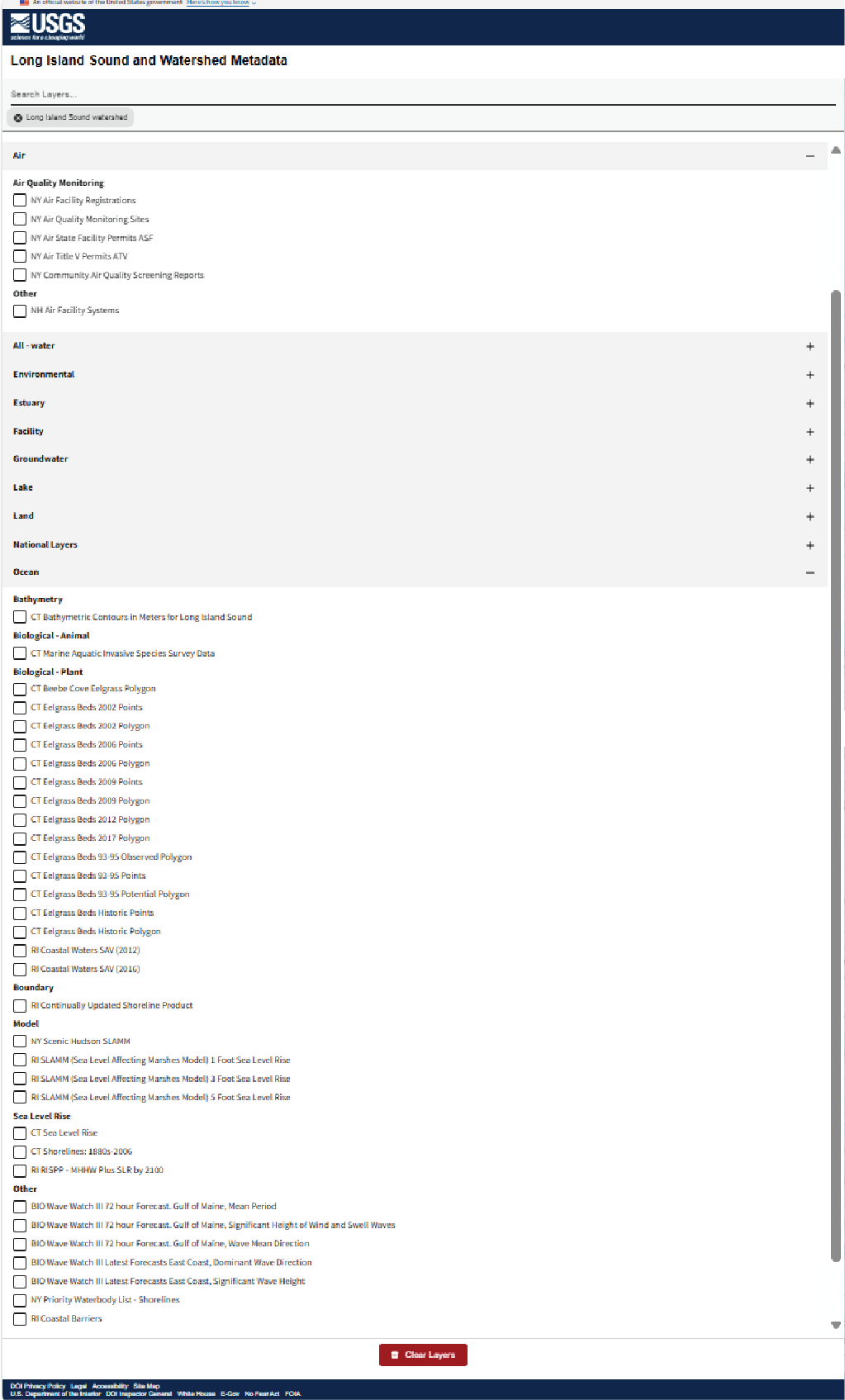
Screenshot showing examples of layers available within the Long Island Sound and Watershed Metadata map application by category (layer) and subcategory (characteristic).
The application provides tools to visualize and filter metadata in an online interactive map and includes several features that allow users to search and filter available layers to visualize and export metadata (fig. 4), including:
-
• a sidebar to change the base map,
-
• the ability to select layers, such as water-quality sampling layers (including additional filters to visualize metadata for the selected layers),
-
• a search bar to find layers by keyword and data type,
-
• a legend that provides information about the status of the layers active in the map, and
-
• an export button to download metadata for all active layers.
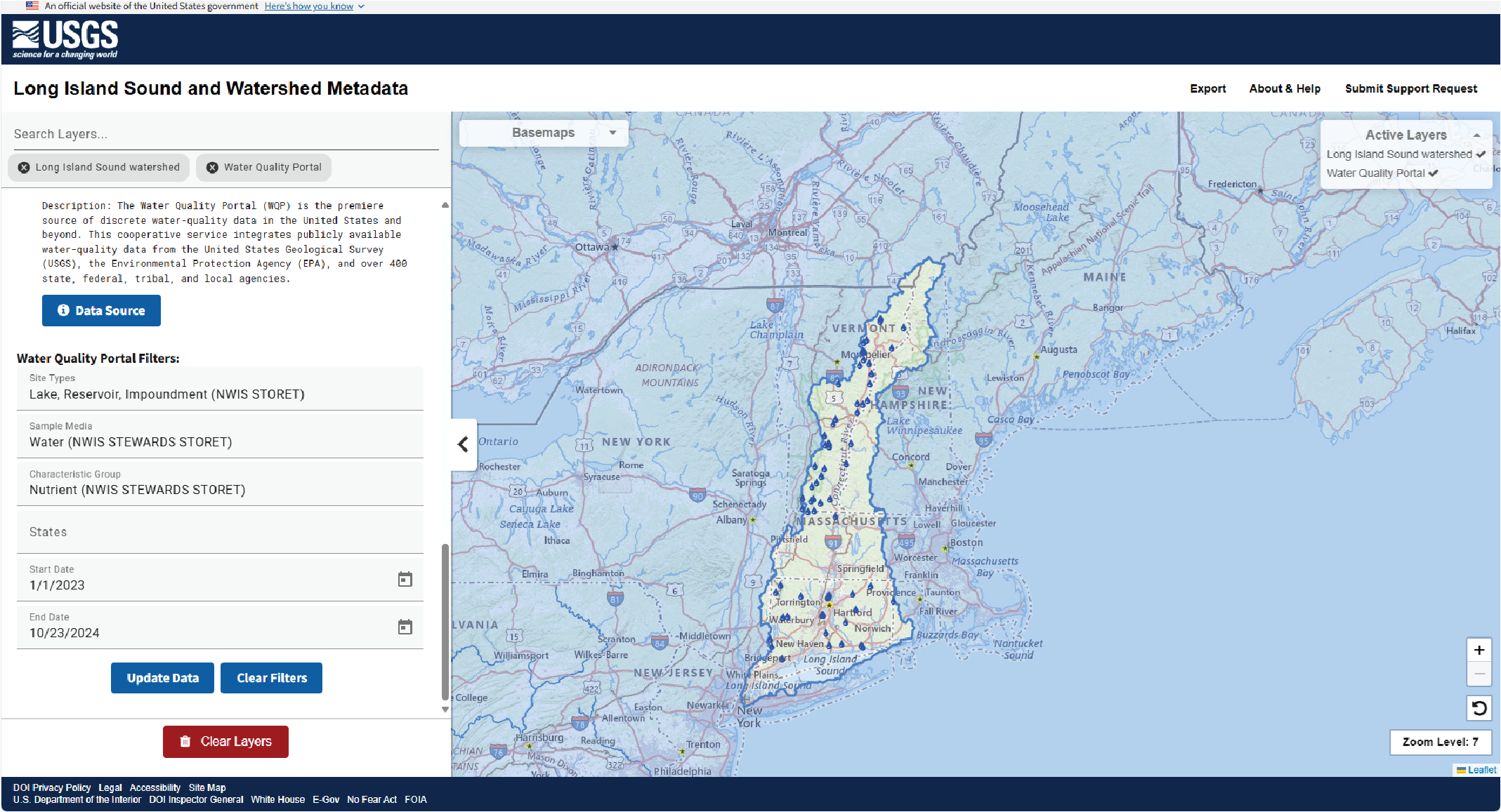
Screenshot showing an example view of the Long Island Sound and Watershed Metadata map application, displaying detailed filtering available for the U.S. Geological Survey and the U.S. Environmental Protection Agency Water Quality Portal layer. Blue water droplets represent metadata information from the Water Quality Portal. The Water Quality Portal layer displays the following advanced filtering options: “Site Types” is Lake, Reservoir, Impoundment (NWIS STORET); “Sample Media” is water (STEWARDS) and Water (NWIS STEWARDS STORET); “Characteristic Group” is Nutrient (NWIS STEWARDS STORET); “Start Date” is 1/1/2023; “End Date” is 10/23/2024.
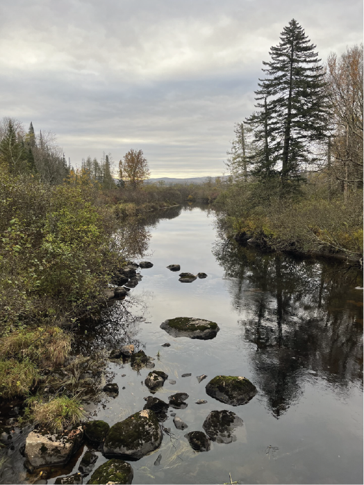
Upstream view of Moose River in Victory, Vermont, during a discrete sampling trip; photograph by Danny Hansen, U.S. Geological Survey.
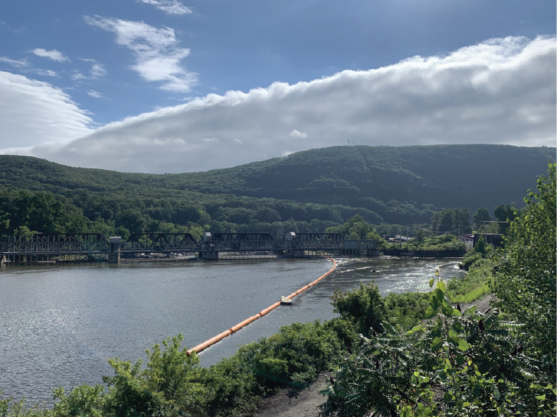
Downstream view of the Connecticut River in North Walpole, New Hampshire; photograph by Danny Hansen, U.S. Geological Survey.
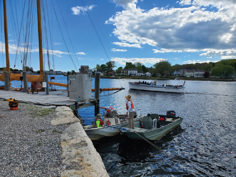
U.S. Geological Survey staff install a continuous water-quality monitoring gage on the Mystic River at the Mystic Seaport in Mystic, Connecticut; photograph by Brittney Izbicki, U.S. Geological Survey.
Acknowledgments
The authors thank the many Long Island Sound stakeholders who provided information and data to be represented in the interactive map application. This project has been funded wholly or in part by the U.S. Environmental Protection Agency under interagency agreement (DW–014–92566801) with the U.S. Geological Survey.
References Cited
Dewitz, J., 2023, National land cover database (NLCD) 2021 products: U.S. Geological Survey data release, accessed May 15, 2024, at https://doi.org/10.5066/P9JZ7AO3.
Latimer, J.S., Tedesco, M.A., Swanson, R.L., Yarish, C., Stacey, P.E., and Garza, C., 2014, Long Island Sound—Prospects for the urban sea: New York, N.Y., Springer, 558 p. [Also available at https://doi.org/10.1007/978-1-4614-6126-5.]
Long Island Sound Study, 2024, Long Island Sound—By the numbers: Long Island Sound Study web page, accessed May 23, 2024, at https://longislandsoundstudy.net/about-the-sound/by-the-numbers/.
Parker, M.A., 2024, Watershed population: Long Island Sound Study website, accessed April 26, 2024, at https://longislandsoundstudy.net/ecosystem-target-indicators/watershed-population/.
U.S. Geological Survey, 2024, Long Island Sound and watershed metadata: U.S. Geological Survey map interface, accessed November 12, 2024, at https://apps.usgs.gov/liswmetadata/?layer0=Long%20Island%20Sound%20watershed.
For more information, contact:
Director, New York Water Science Center
dc_ny@usgs.gov
https://www.usgs.gov/centers/new-york-water-science-center
Publishing support provided by the Pembroke Publishing Service Center
Disclaimers
Any use of trade, firm, or product names is for descriptive purposes only and does not imply endorsement by the U.S. Government.
Although this information product, for the most part, is in the public domain, it also may contain copyrighted materials as noted in the text. Permission to reproduce copyrighted items must be secured from the copyright owner.
Suggested Citation
Stagnitta, T.J., Groseclose, G.N., Beckers, H.N., and Fisher, S.C., 2025, The Long Island Sound and Watershed Metadata map application: U.S. Geological Survey Fact Sheet 2025–3019, 6 p., https://doi.org/10.3133/fs20253019.
ISSN: 2327-6932 (online)
Study Area
| Publication type | Report |
|---|---|
| Publication Subtype | USGS Numbered Series |
| Title | The Long Island Sound and Watershed Metadata map application |
| Series title | Fact Sheet |
| Series number | 2025-3019 |
| DOI | 10.3133/fs20253019 |
| Publication Date | May 16, 2025 |
| Year Published | 2025 |
| Language | English |
| Publisher | U.S. Geological Survey |
| Publisher location | Reston, VA |
| Contributing office(s) | New York Water Science Center |
| Description | 6 p. |
| Country | United States |
| State | Connecticut, Massachusetts, New Hampshire, New York, Rhode Island, Vermont |
| Other Geospatial | Long Island Sound and watershed |
| Online Only (Y/N) | Y |
| Additional Online Files (Y/N) | N |