

Assessment of Undiscovered Oil and Gas Resources in the Lower Cretaceous Hosston and Travis Peak Formations, U.S. Gulf Coast, 2024
Links
- Document: Report (2.89 MB pdf) , HTML , XML
- Data Release: USGS data release - USGS National and Global Oil and Gas Assessment Project-Gulf Coast Mesozoic Province, Lower Cretaceous Travis Peak and Hosston Formations: Assessment Unit Boundaries, Assessment Input Data, and Fact Sheet Data Tables
- NGMDB Index Page: National Geologic Map Database Index Page (html)
- Download citation as: RIS | Dublin Core
Abstract
Using a geology-based assessment methodology, the U.S. Geological Survey estimated undiscovered, technically recoverable mean resources of 28 million barrels of oil and 35.8 trillion cubic feet of gas in conventional and continuous accumulations within the Lower Cretaceous Hosston and Travis Peak Formations of the onshore U.S. Gulf Coast region.
Introduction
The U.S. Geological Survey (USGS) completed a geology-based, quantitative assessment of undiscovered, technically recoverable conventional and continuous (unconventional) resources within the Lower Cretaceous Hosston and Travis Peak Formations and age-equivalent strata (fig. 1; tables 1, 2). These formations are part of the Upper Jurassic–Cretaceous–Tertiary Composite Total Petroleum System (TPS) within the onshore, domestic, and State waters portion of the northern Gulf of America. More than 14,900 wells have been drilled into the Hosston and Travis Peak Formations (S&P Global Commodity Insights, 2024), of which 3,980 new wells have been drilled since the previous USGS assessment in 2002.
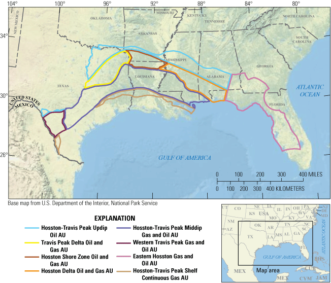
Map showing the seven conventional and one continuous oil and gas assessment units (AUs) of the Lower Cretaceous Hosston and Travis Peak Formations, U.S. Gulf Coast.
Table 1.
Key input data for seven conventional and one continuous oil and gas assessment units in the Hosston and Travis Peak Formations, U.S. Gulf Coast.[Gray shading indicates not applicable. The average estimated ultimate recovery (EUR) input is the minimum, median, maximum, and calculated mean. AU, assessment unit; MMBO, million barrels of oil; BCFG, billion cubic feet of gas; %, percent]
Table 2.
Results for seven conventional and one continuous oil and gas assessment units in the Hosston and Travis Peak Formations, U.S. Gulf Coast.[Gray shading indicates not applicable. Results shown are fully risked estimates. F95 represents a 95-percent chance of at least the amount tabulated; other fractiles are defined similarly. MMBO, million barrels of oil; BCFG, billion cubic feet of gas; NGL, natural gas liquids; MMBNGL, million barrels of natural gas liquids]
Geologic Summary and Total Petroleum System Elements
The Early Cretaceous (Berriasian–Hauterivian) Travis Peak Formation in Texas and southern Arkansas is time correlative to the Hosston Formation in Louisiana and eastward. These formations represent the second clastic, first-order sequence deposited in the onshore Gulf Coast region after Late Triassic continental rifting opened the basin (Salvador, 1987). The Hosston and Travis Peak Formations were deposited during the largest global marine transgression of the Early Cretaceous (Ewing and Galloway, 2019). The lower contact is a deeply incised erosional unconformity in many locations, and the upper contact is the regionally extensive, transgressive carbonate seal of the Cretaceous Sligo and Pettet Formations. Mature source rocks containing Type II and IIS (oil-prone) kerogen underlie the geographic extent of the onshore Hosston and Travis Peak and include the Upper Jurassic Smackover (Whidden and others, 2023; Birdwell and others, 20241), Bossier (Paxton and others, 2017a), and Haynesville (Paxton and others, 2017b) Formations.
Assessment Units
The USGS defined and quantitatively assessed seven conventional and one continuous assessment units (AUs) for the Hosston and Travis Peak Formations within the onshore, domestic, and State waters portions of the Upper Jurassic–Cretaceous–Tertiary Composite TPS (fig. 1). Table 1 and Burke (2025) provide the input data used for calculating the undiscovered resources within these AUs.
The Hosston-Travis Peak Updip Oil AU is defined by the coastal plain lithofacies that contain reworked Eagle Mills Formation and pre-Callovian salt basin-fill deposits (Snedden and Galloway, 2019). The northern boundary is defined by either the geographic extent of these lithofacies or by the TPS boundary. The western boundary is the United States-Mexico border. The eastern boundary is defined by the geographic extent of known Jurassic source rocks.
The Travis Peak Delta Oil and Gas AU contains fluvial and deltaic lithofacies of the paleo Travis Peak delta, which is associated with the ancestral Red River. The northern boundary is marked by the transition to the coastal plain lithofacies. The southern boundary is the downdip extent of salt-weld terrain and coincides with the Hosston-Travis Peak Middip Gas and Oil AU. The western boundary coincides with the TPS boundary. The eastern boundary is defined by the lithofacies transition from fluvial-deltaic to shore-zone facies.
The Hosston Shore Zone Oil and Gas AU contains oil and gas accumulations within terrigenous clastic strata that have been extensively reworked by shore-zone processes. This AU is bound in the north by the coastal plain lithofacies and in the south by the southern extent of salt-weld terrain. The western boundary is marked by the transition to the ancestral Red River fluvial-deltaic lithofacies, and the eastern boundary is defined by the transition to the ancestral Mississippi River fluvial-deltaic lithofacies.
The Hosston Delta Oil and Gas AU encompasses fluvial-deltaic lithofacies of the ancestral Hosston delta at the terminus of the ancestral Mississippi River. The northern boundary is defined by the transition to the coastal plain lithofacies. The southern boundary is marked by the downdip extent of salt-weld terrain. The western boundary coincides with the shore-zone lithofacies transition. The eastern boundary marks the geographic extent of known source rocks.
The Hosston-Travis Peak Middip Gas and Oil AU is a geographically extensive AU containing a variety of reservoir lithofacies including fluvial-deltaic, shore-zone, open-marine, and shelf deposits. The northern boundary is defined by the southern extent of salt-weld terrain, which facilitated petroleum migration. The southern AU boundary is defined by the Lower Cretaceous shelf margin or State waters. The western boundary marks the lithofacies transition into fluvial-deltaic deposits associated with the Rio Grande River.
The Western Travis Peak Gas and Oil AU encompasses the Rio Grande embayment and contains fluvial-deltaic, shore-zone, and shelfal reservoir lithofacies. The northern boundary is the transition to the coastal plain lithofacies. The western boundary coincides with the lithofacies change to open-marine deposits. The Lower Cretaceous shelf margin defines the southern boundary of this AU. The eastern AU boundary is the United States-Mexico border.
The Eastern Hosston Gas and Oil AU includes Lower Cretaceous, age-equivalent strata in Florida, Georgia, and Alabama. This AU may contain hydrocarbons that migrated from the Jurassic Smackover Formation, from the underlying pod of Lower Cretaceous source rocks (Roberts-Ashby and others, 2019) in the South Florida Basin, or from an unknown and undiscovered source rock beneath the western margin of the Florida Peninsula. The northern boundary is defined by the TPS boundary. The eastern boundary is defined by the western margin of the Ocala Arch and the north–south-trending Florida Peninsula Arch. The southern boundary is the rim of the South Florida Basin. State waters delineate the western boundary of this AU.
The Hosston-Travis Peak Shelf Continuous Gas AU is defined by the Lower Cretaceous shelf margin to the north, State waters to the east, and the United States-Mexico border to the west. The southern extent is defined by the isotherm representing the high-temperature maximum for technically recoverable continuous resources (Whidden and others, 2023). Potential continuous gas accumulations may occur within organic-lean siltstones and mudstones of continental origin or within basin-floor fan complexes downdip of the major fluvial systems.
Undiscovered Resources Summary
The USGS quantitatively assessed undiscovered, technically recoverable resources within seven conventional and one continuous AUs within the Hosston and Travis Peak Formations of the U.S. Gulf Coast region (table 2). The fully risked, estimated mean totals for conventional and continuous oil and gas resources are 28 million barrels of oil (MMBO), with an F95–F5 range from 13 to 59 MMBO; 35.8 trillion cubic feet of gas (TCFG), with an F95–F5 range from 8.8 to 74.8 TCFG; and 156 million barrels of natural gas liquids (MMBNGL), with an F95–F5 range from 40 to 336 MMBNGL.
For More Information
Assessment results are also available at the USGS Energy Resources Program website, https://www.usgs.gov/programs/energy-resources-program.
References Cited
Birdwell, J.E., Whidden, K.J., Paxton, S.T., Kinney, S.A., Gardner, R.D., Pitman, J.K., French, K.L., Mercier, T.J., Woodall, C.A., Leathers-Miller, H.M., and Schenk, C.J., 2024, Assessment of undiscovered, technically recoverable conventional oil and gas resources in the Upper Jurassic Smackover Formation, U.S. Gulf Coast, 2022: U.S. Geological Survey Fact Sheet 2023–3046, 4 p., accessed October 19, 2024, at https://doi.org/10.3133/fs20233046.
Burke, L.A., 2025, USGS National and Global Oil and Gas Assessment Project—Gulf Coast Mesozoic Province, Lower Cretaceous Travis Peak and Hosston Formations—Assessment unit boundaries, assessment input forms, and fact sheet data tables: U.S. Geological Survey data release, https://doi.org/10.5066/P1JPWRAY.
Ewing, T.E., and Galloway, W.E., 2019, Evolution of the Northern Gulf of Mexico sedimentary basin, chap. 16 of Miall, A.D., ed., The sedimentary basins of the United States and Canada (2d ed.): Elsevier, p. 627–694, accessed March 8, 2022, at https://doi.org/10.1016/B978-0-444-63895-3.00016-4.
Paxton, S.T., Pitman, J.K., Kinney, S.A., Gianoutsos, N.J., Pearson, O.N., Whidden, K.J., Dubiel, R.F., Schenk, C.J., Burke, L.A., Klett, T.R., Leathers-Miller, H.M., Mercier, T.J., Haines, S.S., Varela, B.A., Le, P.A., Finn, T.M., Gaswirth, S.B., Hawkins, S.J., Marra, K.R., and Tennyson, M.E., 2017a, Assessment of undiscovered oil and gas resources in the Bossier Formation, U.S. Gulf Coast, 2016: U.S. Geological Survey Fact Sheet 2017–3015, 2 p., accessed May 29, 2023, at https://doi.org/10.3133/fs20173015.
Paxton, S.T., Pitman, J.K., Kinney, S.A., Gianoutsos, N.J., Pearson, O.N., Whidden, K.J., Dubiel, R.F., Schenk, C.J., Burke, L.A., Klett, T.R., Leathers-Miller, H.M., Mercier, T.J., Haines, S.S., Varela, B.A., Le, P.A., Finn, T.M., Gaswirth, S.B., Hawkins, S.J., Marra, K.R., and Tennyson, M.E., 2017b, Assessment of undiscovered oil and gas resources in the Haynesville Formation, U.S. Gulf Coast, 2016: U.S. Geological Survey Fact Sheet 2017–3016, 2 p., accessed May 29, 2023, at https://doi.org/10.3133/fs20173016.
Roberts-Ashby, T.L., Hackley, P.C., Lohr, C.D., Schenk, C.J., Mercier, T.J., Whidden, K.J., Le, P.A., Tennyson, M.E., Gaswirth, S.B., Woodall, C.A., Brownfield, M.E., Leathers-Miller, H.M., Marra, K.R., and Finn, T.M., 2019, Assessment of undiscovered oil and gas resources in the South Florida Basin, 2016: U.S. Geological Survey Fact Sheet 2018–3074, 4 p., accessed May 21, 2023, at https://doi.org/10.3133/fs20183074.
Salvador, A., 1987, Late Triassic–Jurassic paleogeography and origin of Gulf of Mexico basin: AAPG Bulletin, vol. 71, no. 4, p. 419–451, accessed September 1, 2022, at https://doi.org/10.1306/94886EC5-1704-11D7-8645000102C1865D.
Snedden, J.W., and Galloway, W.E., 2019, The Gulf of Mexico sedimentary basin—Depositional evolution and petroleum applications: Cambridge, England, Cambridge University Press, 326 p., accessed February 11, 2021, at https://doi.org/10.1017/9781108292795.
Whidden, K.J., Birdwell, J.E., Gardner, R.D., Kinney, S.A., Paxton, S.T., Pitman, J.K., and Schenk, C.J., 2023, Assessment of continuous oil and gas resources in the Upper Jurassic Smackover Formation of the onshore U.S. Gulf Coast, 2022: U.S. Geological Survey Fact Sheet 2023–3021, 4 p., accessed November 22, 2024, at https://doi.org/10.3133/fs20233021.
Disclaimers
Any use of trade, firm, or product names is for descriptive purposes only and does not imply endorsement by the U.S. Government.
Although this information product, for the most part, is in the public domain, it also may contain copyrighted materials as noted in the text. Permission to reproduce copyrighted items must be secured from the copyright owner.
Suggested Citation
Burke, L.A., Paxton, S.T., Kinney, S.A., Gianoutsos, N.J., Dubiel, R.F., Pitman, J.K., Schenk, C.J., Mercier, T.J., Le, P.A., and Leathers-Miller, H.M., 2025, Assessment of undiscovered oil and gas resources in the Lower Cretaceous Hosston and Travis Peak Formations, U.S. Gulf Coast, 2024: U.S. Geological Survey Fact Sheet 2025–3021, 4 p., https://doi.org/10.3133/fs20253021.
ISSN: 2327-6932 (online)
Study Area
| Publication type | Report |
|---|---|
| Publication Subtype | USGS Numbered Series |
| Title | Assessment of undiscovered oil and gas resources in the Lower Cretaceous Hosston and Travis Peak Formations, U.S. Gulf Coast, 2024 |
| Series title | Fact Sheet |
| Series number | 2025-3021 |
| DOI | 10.3133/fs20253021 |
| Publication Date | May 07, 2025 |
| Year Published | 2025 |
| Language | English |
| Publisher | U.S. Geological Survey |
| Publisher location | Reston VA |
| Contributing office(s) | Central Energy Resources Science Center |
| Description | Report: 4 p.; Data Release |
| Country | United States |
| State | Alabama, Arkansas, Georgia, Louisiana, Mississippi, Texas |
| Other Geospatial | Gulf Coast area |
| Online Only (Y/N) | Y |