

Assessment of Conventional and Continuous Oil and Gas Resources in the Mowry Composite Total Petroleum System in the Southwestern Wyoming Province, Wyoming, Colorado, and Utah, 2024
Links
- Document: Report (1.50 MB pdf) , HTML , HTML
- Data Release: USGS data release - USGS National and Global Oil and Gas Assessment Project - Southwestern Wyoming Province, Mowry Shale Conventional and Continuous Assessment Unit Boundaries, Assessment Input Data, and Fact Sheet Data Tables
- NGMDB Index Page: National Geologic Map Database Index Page (html)
- Download citation as: RIS | Dublin Core
Abstract
Using a geology-based assessment methodology, the U.S. Geological Survey estimated undiscovered, technically recoverable mean conventional and continuous resources of 473 million barrels of oil and 27 trillion cubic feet of gas in the Mowry Composite Total Petroleum System in the Southwestern Wyoming Province, Wyoming, Colorado, and Utah.
Introduction
The U.S. Geological Survey (USGS) assessed undiscovered, technically recoverable conventional and continuous (unconventional) oil and gas resources in the Early to Late Cretaceous (Albian to Coniacian) Mowry Composite Total Petroleum System (TPS) in the Southwestern Wyoming Province in Wyoming, Colorado, and Utah (figs. 1, 2). The Mowry Composite TPS covers the entire Southwestern Wyoming Province, which includes most of southwestern Wyoming and small areas in northwestern Colorado and northeastern Utah.
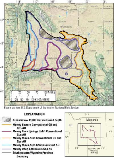
Map showing three conventional and two continuous assessment units (AUs) in the Mowry Composite Total Petroleum System of the Southwestern Wyoming Province.
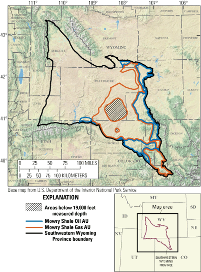
Map showing two continuous assessment units (AUs) in the Mowry Composite Total Petroleum System of the Southwestern Wyoming Province.
The Mowry Composite TPS was previously assessed by the USGS in 2005 (Kirschbaum and Roberts, 2005), and at that time, one conventional and one continuous assessment unit (AU) were defined and overlapped one another. Three conventional and four continuous AUs were defined for this assessment of potential hydrocarbon resources in the Mowry Composite TPS (figs. 1, 2): a Mowry Eastern Conventional Oil and Gas AU, a Mowry Rock Springs Uplift Conventional Gas AU, a Mowry Moxa Arch Conventional Oil and Gas AU, a Mowry Moxa Arch Continuous Gas AU, a Mowry Deep Continuous Gas AU, a Mowry Shale Oil AU, and a Mowry Shale Gas AU. Multiple criteria were used to define these AUs, including spatial and lithologic variability and thickness, depositional environment, natural fracture presence, and source rock thermal maturity.
Geologic Summary
From oldest to youngest, the Mowry Composite TPS consists of the Lower Cretaceous Cloverly Formation and Dakota Sandstone, the Lower Cretaceous Thermopolis Shale and Muddy Sandstone Member, the Lower Cretaceous Shell Creek Shale, the Upper Cretaceous Mowry Shale, and the Upper Cretaceous Frontier Formation (fig. 3).
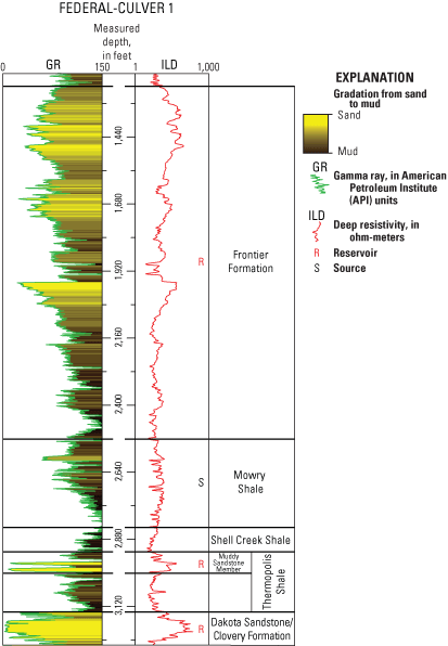
Type log image of the Federal-Culver 1 well (S24, T28N, R92W), which highlights the stratigraphy of the Mowry Composite Total Petroleum System.
The Mowry Shale is a marine, organic-rich, siliceous shale that was deposited during the early stages of the second-order Greenhorn transgressive cycle (Kauffman and Caldwell, 1993). Regional studies indicate that the Mowry Shale has total organic carbon (TOC) content of as much as 5 weight percent (Burtner and Warner, 1984; French and others, 2022). However, Mowry Shale facies change westward toward the clastic source area from anoxic, laminated mudstones into oxic, bioturbated mudstones and sandstones (Burtner and Warner, 1984). The Mowry Shale is the primary source of oil and gas for the Mowry Composite TPS, but contributions from the Permian Phosphoria Formation are possible.
Primary reservoirs within the Mowry Composite TPS comprise fluvial, estuarine, and nearshore marine sandstones of the Dakota Sandstone and Muddy Sandstone Member and equivalent strata, as well as the Frontier Formation (fig. 3). Sandstone reservoirs are prevalent throughout the entire TPS, and most gas production is focused along the axes of the Moxa Arch and Rock Springs Uplift (fig. 1).
Total Petroleum System and Assessment Units
The USGS defined three conventional and four continuous AUs within the Mowry Composite TPS (tables 1, 2). The updip boundaries of the Mowry Eastern Conventional Oil and Gas AU and Mowry Rock Springs Uplift Conventional Gas AU are defined by bounding uplifts (fig. 1). The downdip boundaries of these two AUs are defined by a depth cutoff on the top of the Mowry Shale at 13,000 feet (ft) measured depth (MD). In general, mud weight, drill stem test, porosity and permeability, and production data from reservoirs below this depth cutoff indicate that the rocks are overpressured (greater than 0.5 pounds per square inch per foot [psi/ft]) and contain very tight sandstone reservoirs (IHS Markit, 2022). Overall, sandstones within these two conventional AUs have normal reservoir pressures, average porosities greater than 10 percent, average permeabilities greater than 0.1 millidarcies (mD), and distinct oil-water or gas-water contacts. Trap styles in these two conventional AUs are dominated by structural features such as anticlines and faults, and some fields also contain smaller, stratigraphic traps (Nehring Associates, Inc., 2018). Additionally, faults and natural fractures, which are abundant in both AUs, are critical for well performance (DeJarnett and others, 2001).
Table 1.
Key input data for three conventional and four continuous oil and gas assessment units in the Mowry Composite Total Petroleum System of the Southwestern Wyoming Province.[Gray shading indicates not applicable. The average estimated ultimate recovery (EUR) input is the minimum, mode, maximum, and calculated mean. AU, assessment unit; MMBO, million barrels of oil; BCFG, billion cubic feet of gas; %, percent]
The southern boundary of the Mowry Moxa Arch Conventional Oil and Gas AU is also defined by uplift (fig. 1). The western and eastern boundaries are defined by the 3,000-ft thickness contour of the Hilliard Shale, which directly overlies the Frontier Formation on the Moxa Arch. The northern boundary is defined by the northernmost oil-gas-water contact along the Moxa Arch (Curry, 1992). Wells within the Mowry Moxa Arch Conventional Oil and Gas AU have some of the lowest gas-oil ratios yet are some of the deepest wells in the Southwestern Wyoming Province (IHS Markit, 2022). Law and Clayton (1987) attribute the lower temperature gradients and presence of oil instead of gas to the meteoric recharge of cold water along faults adjacent to the Uinta Mountains Uplift. Similar to the other conventional AUs, sandstone reservoirs within the Mowry Moxa Arch Conventional Oil and Gas AU fields have normal reservoir pressures, average porosities greater than 10 percent, average permeabilities greater than 0.1 mD, and distinct oil-water or gas-water contacts.
The Mowry Moxa Arch Continuous Gas AU is bounded to the northwest by the Wyoming Thrust Belt, to the south by the Mowry Moxa Arch Conventional Oil and Gas AU, and to the north, west, and east by the 13,000-ft-MD cutoff on the top of the Mowry Shale. Wells within this AU are generally characterized as part of a “regional” gas accumulation and have no distinct gas-water contacts (Miller and others, 1992). Reservoirs are typically overpressured, have porosity values less than 10 percent, and have permeabilities less than 0.1 mD. Field outlines within the AU have merged through time into a “regional” accumulation, and production is enhanced by natural fracturing along the crest of the Moxa Arch (DeJarnett and others, 2001). Regionally, the area below the 13,000-ft-MD cutoff on the top of the Mowry Shale and above 19,000 ft MD defines the Mowry Deep Continuous Gas AU. Reservoirs within this AU, which comprise the Dakota and equivalents, Muddy Sandstone Member, and Frontier, have strong overpressure, permeabilities less than 0.1 mD, and no distinct gas-water contacts. Areas below 19,000 ft MD were removed from the AU because these areas are too deep to drill laterally with current technology. These areas are specific to the areas within the Great Divide, Washakie, Sand Wash, and northern Green River Basins (fig. 1).
The Mowry Shale Oil AU and Mowry Shale Gas AU are only located on the eastern side of the Rock Springs Uplift in the Southwestern Wyoming Province (fig. 2). The Mowry Shale Oil AU boundary was defined as the area greater than the modeled 1.3-percent vitrinite reflectance (Ro) thermal maturity contour for gas. The western edge of the AU is delineated by an east-to-west facies change from laminated, anoxic mudstone to oxic, bioturbated mudstone and sandstone (Burtner and Warner, 1984). West of the anoxic mudstone facies, the Mowry Shale was deposited in shallower waters closer to the clastic source area, which reduced the preservation and petroleum potential of the source rocks (Burtner and Warner, 1984). Geochemical data from the Mowry Shale in the adjacent Wind River Basin also highlight a marked decrease in the hydrogen index and TOC content of the Mowry Shale from east to west (Finn and others, 2023).
The Mowry Shale Gas AU is defined by the area greater than the 1.3-percent Ro thermal maturity contour for gas and by the western facies boundary. Similar to the Mowry Deep Continuous Gas AU, areas where the Mowry Shale is expected to occur below 19,000 ft MD were removed from the Mowry Shale Gas AU because these areas are too deep to drill laterally with current technology (fig. 2).
Assessment input data are summarized in table 1 and Hearon (2025). No production data exist from horizontal Mowry Shale wells within the Southwestern Wyoming Province. As a result, production data from the Mowry Shale in other Wyoming basins, specifically the Powder River, Wind River, and Bighorn Basins, were used as analogs for the assessment of continuous oil and gas resources in this province.
Undiscovered Resources Summary
The USGS quantitatively assessed oil and gas resources in three conventional and four continuous AUs in the Mowry Composite TPS in the Southwestern Wyoming Province (table 2). The fully risked, estimated mean totals are 473 million barrels of oil (MMBO) with an F95–F5 fractile range from 117 to 962 MMBO; 27,305 billion cubic feet of gas (BCFG) with an F95–F5 range from 7,414 to 52,799 BCFG; and 84 million barrels of natural gas liquids (MMBNGL) with an F95–F5 range from 25 to 154 MMBNGL.
Table 2.
Results for three conventional and four continuous oil and gas assessment units in the Mowry Composite Total Petroleum System of the Southwestern Wyoming Province.[Gray shading indicates not applicable. Results shown are fully risked estimates. F95 represents a 95-percent chance of at least the amount tabulated; other fractiles are defined similarly. MMBO, million barrels of oil; BCFG, billion cubic feet of gas; NGL, natural gas liquids; MMBNGL, million barrels of natural gas liquids]
For More Information
Assessment results are also available at the USGS Energy Resources Program website, https://www.usgs.gov/programs/energy-resources-program.
References Cited
Burtner, R.L., and Warner, M.A., 1984, Hydrocarbon generation in Lower Cretaceous Mowry and Skull Creek Shales of the Northern Rocky Mountain area, in Woodward, J., Meissner, F.F., and Clayton, J.L., eds., Hydrocarbon source rocks of the Greater Rocky Mountain Region: Rocky Mountain Association of Geologists, p. 449–467.
DeJarnett, B.B., Lim, F.H., Krystinik, L.F., and Bacon, M.L., 2001, Greater Green River Basin production improvement project, final report: [U.S. Department of Energy], prepared by Union Pacific Resources, Fort Worth, Tex., and Anadarko Petroleum Corporation, Houston, Tex., under contract no. DE–AC21–95MC31063, [variously paged; 2242 p.], accessed June 3, 2024, at https://doi.org/10.2172/810458.
Finn, T.M., Dreier, M.F., and Oliver, T.A., 2023, New source rock data for the Mowry and Thermopolis Shales in the Wind River Basin, Wyoming: U.S. Geological Survey data release, accessed October 10, 2024, at https://doi.org/10.5066/P9ZJ4VU4.
French, K.L., Birdwell, J.E., and Lillis, P.G., 2022, Geochemistry of the Cretaceous Mowry Shale in the Wind River Basin, Wyoming: Geological Society of America Bulletin, v. 135, nos. 7–8, p. 1899–1922, accessed June 3, 2024, at https://doi.org/10.1130/B36382.1.
Hearon, J.S., 2025, USGS National and Global Oil and Gas Assessment Project—Southwestern Wyoming Province, Mowry Shale Composite Total Petroleum System conventional and continuous assessment unit boundaries and assessment input data forms: U.S. Geological Survey data release, https://doi.org/10.5066/P1J8WGJG.
IHS Markit, 2022, US well history and production database: Englewood, Colo., IHS Markit, accessed December 15, 2022, at https://www.ihsenergy.com. [Available from IHS Markit, 15 Inverness Way East, Englewood, CO 80112.]
Kirschbaum, M.A., and Roberts, L.N.R., 2005, Geologic assessment of undiscovered oil and gas resources in the Mowry Composite Total Petroleum System, Southwestern Wyoming Province, Wyoming, Colorado, and Utah, chap. 5 of U.S. Geological Survey Southwestern Wyoming Province Assessment Team, comps., Petroleum systems and geologic assessment of oil and gas in the Southwestern Wyoming Province, Wyoming, Colorado, and Utah (ver. 1): U.S. Geological Survey Digital Data Series DDS–69–D, 27 p., 1 CD–ROM, accessed June 3, 2024, at https://pubs.usgs.gov/dds/dds-069/dds-069-d/REPORTS/69_D_CH_5.pdf.
Law, B.E., and Clayton, J.L., 1987, A burial, thermal, and hydrocarbon source rock evaluation of Lower Cretaceous rocks in the southern Moxa Arch area, Utah and Wyoming [abs.], in Miller, W.R., ed., The Thrust Belt revisited—Wyoming Geological Association 38th Field Conference, Jackson Hole, Wyo., September 8–11, 1987, Guidebook: Wyoming Geological Association, 357 p.
Disclaimers
Any use of trade, firm, or product names is for descriptive purposes only and does not imply endorsement by the U.S. Government.
Although this information product, for the most part, is in the public domain, it also may contain copyrighted materials as noted in the text. Permission to reproduce copyrighted items must be secured from the copyright owner.
Suggested Citation
Hearon, J.S., Schenk, C.J., Gelman, S.E., Johnson, B.G., Lagesse, J.H., Mercier, T.J., Leathers-Miller, H.M., Timm, K.K., Drake, R.M., II, Cicero, A.D., and Le, P.A., 2025, Assessment of conventional and continuous oil and gas resources in the Mowry Composite Total Petroleum System in the Southwestern Wyoming Province, Wyoming, Colorado, and Utah, 2024: U.S. Geological Survey Fact Sheet 2025–3023, 4 p., https://doi.org/10.3133/fs20253023.
ISSN: 2327-6932 (online)
Study Area
| Publication type | Report |
|---|---|
| Publication Subtype | USGS Numbered Series |
| Title | Assessment of conventional and continuous oil and gas resources in the Mowry Composite Total Petroleum System in the Southwestern Wyoming Province, Wyoming, Colorado, and Utah, 2024 |
| Series title | Fact Sheet |
| Series number | 2025-3023 |
| DOI | 10.3133/fs20253023 |
| Publication Date | May 21, 2025 |
| Year Published | 2025 |
| Language | English |
| Publisher | U.S. Geological Survey |
| Publisher location | Reston VA |
| Contributing office(s) | Central Energy Resources Science Center |
| Description | Report: 4 p.; Data Release |
| Country | United States |
| State | Colorado, Utah, Wyoming |
| Online Only (Y/N) | Y |