

Assessment of Continuous Oil and Gas Resources in the Upper Cretaceous Niobrara Formation in the Southwestern Wyoming Province, Wyoming and Colorado, 2024
Links
- Document: Report (1.25 MB pdf) , HTML , XML
- Data Release: USGS data release - USGS National and Global Oil and Gas Assessment Project - Southwestern Wyoming Province, Niobrara Formation Continuous Assessment Unit Boundaries, Assessment Input Data, and Fact Sheet Data Tables
- NGMDB Index Page: National Geologic Map Database Index Page (html)
- Download citation as: RIS | Dublin Core
Abstract
Using a geology-based assessment methodology, the U.S. Geological Survey estimated undiscovered, technically recoverable mean continuous resources of 703 million barrels of oil and 5.8 trillion cubic feet of gas in the Niobrara Formation in the Southwestern Wyoming Province, Wyoming and Colorado.
Introduction
The U.S. Geological Survey (USGS) assessed undiscovered, technically recoverable continuous (unconventional) oil and gas resources in the Upper Cretaceous (upper Turonian to lower Campanian) Niobrara Formation in the eastern part of the Southwestern Wyoming Province. The Niobrara Formation is present east of the Rock Springs uplift within the Sand Wash, Washakie, and Great Divide Basins in northwestern Colorado and southwestern Wyoming (fig. 1). The Niobrara Formation is regionally extensive due to deposition in the epicontinental Western Interior Seaway at a time when the seaway extended from the present-day Gulf of America, through central North America, and connected with northern boreal waters in the Canadian Rockies (Kauffman, 1977). Changes in sea level affected lithology within the seaway, and the Niobrara Formation records deposition of a third-order transgressive-regressive cycle (Barlow and Kauffman, 1985; Longman and others, 1998). Laramide-age tectonics (Late Cretaceous–Eocene) are responsible for the major structural elements that are currently present in the Southwestern Wyoming Province (fig. 1).
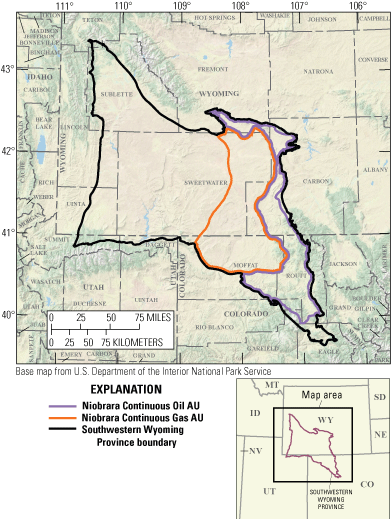
Map showing the Niobrara Formation continuous oil and gas assessment units (AUs) in the Southwestern Wyoming Province, Wyoming and Colorado.
Total Petroleum System and Assessment Units
The Niobrara Total Petroleum System (TPS) is a self-sourced system whereby the source rock and reservoir are both within the Niobrara Formation. The Niobrara Formation within the Southwestern Wyoming Province contains different lithologies than the Niobrara Formation in the Powder River and Denver Basins. In this area, the Niobrara was deposited toward the western margin of the Western Interior Seaway (Drake and Hawkins, 2021). The Niobrara lithology is predominantly calcareous; however, because of its proximal location, substantial dilution of the calcareous components occurred from erosion of and sediment influx from the Sevier highlands to the west. As such, the formation is more calcareous in the east and thickens, becoming more argillaceous and silicious westward, toward the Rock Springs Uplift where it transitions into the silicious, argillaceous Upper Cretaceous Baxter Shale.
In this province, the Niobrara contains multiple cycles of alternating calcareous mudstones/marls and silicious-calcareous mudstones with lesser amounts of shaley limestone. The most calcareous unit is the Fort Hays Limestone Member of the Niobrara, which represents the maximum sea level transgression during Niobrara deposition. Marine (oil-prone) organic matter is preserved primarily within the peloidal calcareous components whereas terrigenous (gas-prone) organic matter is preserved within the detrital silts and clays (Olson and others, 2022). Total organic carbon concentrations are greatest (as much as 4 weight percent) within the marls, which act as the source and principal reservoir for Niobrara hydrocarbon production in this region (Dellenbach, 2016). These marls are informally known as the Buck Peak, Tow Creek, and Wolf Mountain units or benches, and each is associated with an increase in gamma ray and resistivity on petrophysical logs. The interbedded mudstones and the younger, overlying Upper Cretaceous Mancos Shale effectively seal the reservoir units (Vincelette and Foster, 1992). Natural fractures in the Niobrara are typically associated with larger structures, such as synclines and anticlines, which formed during Laramide tectonic activity and were later reopened by Neogene extension. These open fractures have been shown to enhance hydrocarbon production in the region (Vincelette and Foster, 1992).
The USGS defined one oil and one gas assessment unit (AU) for the region. The Niobrara Continuous Oil AU represents a region with a modeled source rock thermal maturity between 0.60 to 1.35 percent vitrinite reflectance (Ro). The Niobrara Continuous Gas AU represents an area where the thermal maturity is greater than 1.35 Ro. The eastern and southeastern boundaries of the TPS were defined by Finn and Johnson (2005) to coincide with Niobrara or stratigraphically equivalent outcrops. The western boundary of the TPS was defined using source rock analyses (Dreier and Warden, 2021) to approximate where the predominant organic matter type transitioned from oil-prone marine kerogen to gas-prone terrigenous kerogen.
Assessment input data are summarized in table 1 and Timm (2025). Input data for oil estimated ultimate recoveries (EURs) from wells required analogs from other areas with Niobrara production. Oil EURs were based on data from the Sand Wash and the Powder River Basins. Gas EURs from vertical wells in the Denver-Julesburg Basin were used as analogs for Niobrara production in this province.
Table 1.
Key input data for two continuous oil and gas assessment units in the Niobrara Formation.[Gray shading indicates not applicable. The average estimated ultimate recovery (EUR) input is the minimum, mode, maximum, and calculated mean. AU, assessment unit; %, percent; MMBO, million barrels of oil; BCFG, billion cubic feet of gas]
Undiscovered Resources Summary
The USGS quantitatively assessed oil and gas resources for the two continuous AUs in the Niobrara Formation (table 2). For undiscovered, technically recoverable continuous oil and gas resources, the mean totals are 703 million barrels of oil (MMBO) with an F95 to F5 fractile range from 195 to 1,375 MMBO; 5,847 billion cubic feet of gas (BCFG), or 5.8 trillion cubic feet of gas, with an F95 to F5 fractile range from 1,477 to 11,800 BCFG; and 180 million barrels of natural gas liquids (MMBNGL) with an F95 to F5 fractile range from 46 to 362 MMBNGL.
Table 2.
Results for two continuous oil and gas assessment units in the Niobrara Formation.[Results shown are fully risked estimates. F95 represents a 95-percent chance of at least the amount tabulated; other fractiles are defined similarly. Gray shading indicates not applicable. MMBO, million barrels of oil; BCFG, billion cubic feet of gas; NGL, natural gas liquids; MMBNGL, million barrels of natural gas liquids]
For More Information
Assessment results are also available at the USGS Energy Resources Program website, https://www.usgs.gov/programs/energy-resources-program.
Niobrara Formation Assessment Team
Kira K. Timm, Christopher J. Schenk, Jane S. Hearon, Thomas M. Finn, Sarah E. Gelman, Cheryl A. Woodall, Tracey J. Mercier, Andrea D. Cicero, Ronald M. Drake II, Geoffrey S. Ellis, Michael H. Gardner, Benjamin G. Johnson, Jenny H. Lagesse, Phuong A. Le, Heidi M. Leathers-Miller, and Scott S. Young
References Cited
Barlow, L.K., and Kauffman, E.G., 1985, Depositional cycles in the Niobrara Formation, Colorado Front Range, in Pratt, L.M., Kauffman, E.G., and Zelt, F.B., eds., Fine-grained deposits and biofacies of the Cretaceous Western Interior Seaway—Evidence of cyclic sedimentary processes: Society for Sedimentary Geology Field Trip Guidebook, v. 4, p. 199–208, accessed April 1, 2025, at https://doi.org/10.2110/sepmfg.04.199.
Dellenbach, B.A., 2016, An outcrop to subsurface stratigraphic analysis of the Niobrara Formation, Sand Wash Basin, Colorado: Golden, Colo., Colorado School of Mines, master’s thesis, 119 p., accessed September 30, 2023, at https://hdl.handle.net/11124/170256.
Drake, W.R., and Hawkins, S.J., 2021, Sequence stratigraphy of the Niobrara Formation—Implications for age-constraining tectonic events and stratigraphic complexities in the Denver-Julesburg Basin, United States: AAPG Bulletin, v. 105, no. 7, p. 1293–1328, accessed August 18, 2022, at https://doi.org/10.1306/12092019098.
Dreier, M., and Warden, A., 2021, Petroleum Geochemistry Research Laboratory programmed pyrolysis method: U.S. Geological Survey web page, accessed October 18, 2022, at https://www.usgs.gov/media/files/petroleum-geochemistry-research-laboratory-programmed-pyrolysis-method.
Finn, T.M., and Johnson, R.C., 2005, Niobrara Total Petroleum System in the southwestern Wyoming Province, chap. 6 of USGS Southwestern Wyoming Province Assessment Team, Petroleum systems and geologic assessment of oil and gas in the Southwestern Wyoming Province, Wyoming, Colorado, and Utah: U.S. Geological Survey Digital Data Series DDS–69–D, 27 p., accessed February 8, 2021, at https://pubs.usgs.gov/dds/dds-069/dds-069-d/reports.html.
Kauffman, E.G., 1977, Geological and biological overview; Western Interior Cretaceous basin: The Mountain Geologist, v. 14, nos. 3–4, p. 75–99, accessed September 1, 2023, at https://eurekamag.com/research/019/027/019027983.php.
Longman, M.W., Luneau, B.A., and Landon, S.M., 1998, Nature and distribution of Niobrara lithologies in the Cretaceous Western Interior Seaway of the Rocky Mountain Region: The Mountain Geologist, v. 35, no. 4, p. 137–170, accessed November 15, 2021, at https://archives.datapages.com/data/rocky-mtn-geologist-pubs/data/003/003001/228_rmag-bk0030228.htm.
Olson, T., Michalchuk, B., Hackley, P., Valentine, B., Parker, J., and Martin, R.S., 2022, Pore systems and organic petrology of cretaceous Mowry and Niobrara source-rock reservoirs, Powder River Basin, Wyoming, USA: International Journal of Coal Geology, v. 264, article 104134, accessed September 5, 2023, at https://doi.org/10.1016/j.coal.2022.104134.
Timm, K.K., 2025, USGS National and Global Oil and Gas Assessment Project—Southwestern Wyoming Province, Niobrara Formation continuous assessment unit boundaries and assessment input data forms: U.S. Geological Survey data release, https://doi.org/10.5066/P9SO70CX.
Vincelette, R.R., and Foster, N.H., 1992, Fractured Niobrara of northwestern Colorado, in Schmoker, J.W., Coalson, E.B., and Brown, C.A., eds., Geological studies relevant to horizontal drilling—Examples from western North America: Rocky Mountain Association of Geologists, p. 227–242, accessed July 28, 2022, at https://archives-datapages-com.usgslibrary.idm.oclc.org/data/rmag/HorizDrilling1992/vinselette_b.htm.
Disclaimers
Any use of trade, firm, or product names is for descriptive purposes only and does not imply endorsement by the U.S. Government.
Although this information product, for the most part, is in the public domain, it also may contain copyrighted materials as noted in the text. Permission to reproduce copyrighted items must be secured from the copyright owner.
Suggested Citation
Timm, K.K., Schenk, C.J., Hearon, J.S., Finn, T.M., Gelman, S.E., Woodall, C.A., Mercier, T.M., Cicero, A.D., Drake, R.M., II, Ellis, G.S., Gardner, M.H., Johnson, B.G., Lagesse, J.H., Le, P.A., Leathers-Miller, H.M., and Young, S.S., 2025, Assessment of continuous oil and gas resources in the Upper Cretaceous Niobrara Formation in the Southwestern Wyoming Province, Wyoming and Colorado, 2024: U.S. Geological Survey Fact Sheet 2025–3025, 4 p., https://doi.org/10.3133/fs20253025.
ISSN: 2327-6932 (online)
Study Area
| Publication type | Report |
|---|---|
| Publication Subtype | USGS Numbered Series |
| Title | Assessment of continuous oil and gas resources in the Upper Cretaceous Niobrara Formation in the Southwestern Wyoming Province, Wyoming and Colorado, 2024 |
| Series title | Fact Sheet |
| Series number | 2025-3025 |
| DOI | 10.3133/fs20253025 |
| Publication Date | June 11, 2025 |
| Year Published | 2025 |
| Language | English |
| Publisher | U.S. Geological Survey |
| Publisher location | Reston VA |
| Contributing office(s) | Central Energy Resources Science Center |
| Description | Report: 2 p.; Data Release |
| Country | United States |
| State | Colorado, Wyoming |
| Other Geospatial | Niobrara Formation |
| Online Only (Y/N) | Y |