

Assessment of Undiscovered Conventional Oil and Gas Resources in the Phosphoria Total Petroleum System of the Southwestern Wyoming Province, 2024
Links
- Document: Report (1.22 MB pdf) , HTML , XML
- Data Release: USGS data release - USGS National and Global Oil and Gas Assessment Project—Phosphoria Total Petroleum System, Southwestern Wyoming Province—Assessment Unit Boundaries, Assessment Input Tables, and Fact Sheet Data Tables
- NGMDB Index Page: National Geologic Map Database Index Page (html)
- Download citation as: RIS | Dublin Core
Abstract
Using a geology-based assessment methodology, the U.S. Geological Survey estimated undiscovered, technically recoverable mean resources of 3 million barrels of oil and 666 billion cubic feet of gas in the Phosphoria Total Petroleum System of the Southwestern Wyoming Province.
Introduction
The U.S. Geological Survey (USGS) assessed the potential for undiscovered, technically recoverable conventional oil and gas resources in the Permian Phosphoria Total Petroleum System (TPS) in the Southwestern Wyoming Province of Wyoming, Utah, and Colorado (fig. 1). The assessment is based on the geologic elements of the Phosphoria TPS (petroleum source rocks, reservoir rocks, traps, seals, and timing), and on the exploration and discovery history of oil and gas fields. The Permian Phosphoria TPS was last assessed for undiscovered conventional oil and gas resources by the USGS in 2005 (Johnson, 2005).
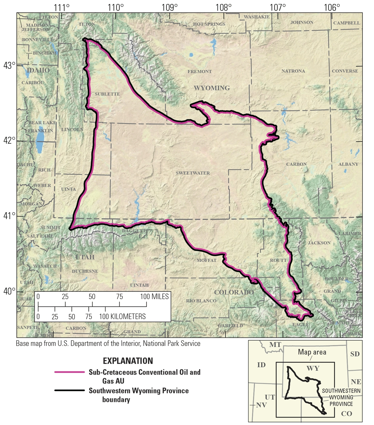
Maps showing the location of the Sub-Cretaceous Conventional Oil and Gas Assessment Unit (AU) in the Southwestern Wyoming Province.
Total Petroleum System
The USGS defined the Phosphoria TPS within the Southwestern Wyoming Province (fig. 1). The primary petroleum source rocks within the Phosphoria TPS are the Meade Peak Member and the Retort Phosphatic Shale Member of the Permian Phosphoria Formation. Both Members of the Phosphoria Formation occur in west-central Wyoming and eastern Idaho, and do not extend eastward across the TPS (Sheldon, 1967; Maughan, 1984). Phosphoria organic-rich mudstones have total organic carbon contents as much as 10 weight percent and contain Type IIS oil-prone kerogen; the Meade Peak Member is as much as 50 meters thick and the Retort Phosphatic Shale Member is as much as 33 meters thick (Maughan, 1984; Lillis and Selby, 2013). Phosphoria organic-rich mudstones in the west-central part of the TPS are modeled to have reached the thermal threshold for oil generation about 85 million years ago (Roberts and others, 2005). The eastward migration of oil generated from thermally mature Phosphoria mudstones is controversial, with the debate focused on the extent and timing of eastward migration (Sheldon, 1967; Lillis and Selby, 2013). Within the TPS, 18 sub-Cretaceous stratigraphic units have produced oil and gas sourced by the Permian Phosphoria Formation (Johnson, 2005). Sub-Cretaceous traps that contain petroleum accumulations are typically structural, although stratigraphic or combination traps may also occur (S&P Global Commodity Insights, 2023).
Assessment Unit
The USGS defined the Sub-Cretaceous Conventional Oil and Gas Assessment Unit (AU) to encompass the Southwestern Wyoming Province (fig. 1). The geologic model for the assessment is for oil and gas generated from organic-rich Phosphoria mudstones to have migrated eastward into reservoirs within pre-Laramide stratigraphic and structural traps, and some portion of the oil and gas later remigrated into reservoirs within Laramide-age traps. Oil and gas reservoirs in the AU are mainly within the Flathead Sandstone, Madison Limestone, Tensleep Sandstone, Weber Sandstone, Phosphoria Formation, Nugget Sandstone, and Morrison Formation, but most of the sub-Cretaceous oil and gas produced within the AU have been from the Pennsylvanian Tensleep and Weber Sandstones. Phosphoria oil trapped in reservoirs in the deeper, central parts of the Greater Green River Basin, Great Divide Basin, Washakie Basin, and Sand Wash Basin may have converted to gas, which is postulated to be the major potential resource in this assessment. More than 1,000 wells drilled in the Southwestern Wyoming Province have produced oil or gas from sub-Cretaceous rocks, but most wells have been drilled along the margins of the TPS where oil is the dominant resource (S&P Global Commodity Insights, 2023). The assessment input data for the Sub-Cretaceous Conventional Oil and Gas AU are summarized in table 1 and Drake (2025).
Undiscovered Resources Summary
The USGS quantitatively assessed undiscovered conventional oil and gas resources within the Sub-Cretaceous Conventional Oil and Gas AU in the Southwestern Wyoming Province (table 2). The estimated mean totals for conventional resources are 3 million barrels of oil (MMBO), with an F95–F5 range from 1 to 5 MMBO; 666 billion cubic feet of gas (BCFG), with an F95–F5 range from 187 to 1,480 BCFG; and 20 million barrels of natural gas liquids (MMBNGL), with an F95–F5 range from 6 to 44 MMBNGL.
Table 2.
Results for one conventional oil and gas assessment unit in the Phosphoria Total Petroleum System of the Southwestern Wyoming Province.[Gray shading indicates not applicable. Results shown are fully risked estimates. F95 represents a 95-percent chance of at least the amount tabulated; other fractiles are defined similarly. MMBO, million barrels of oil; BCFG, billion cubic feet of gas; NGL, natural gas liquids; MMBNGL, million barrels of natural gas liquids]
For More Information
Assessment results are also available at the USGS Energy Resources Program website, https://www.usgs.gov/programs/energy-resources-program.
References Cited
Drake, R.M., II, 2025, USGS National and Global Oil and Gas Assessment Project—Phosphoria Total Petroleum System, Southwestern Wyoming Province—Assessment unit boundaries, assessment input tables, and fact sheet data tables: U.S. Geological Survey data release, https://doi.org/10.5066/P1EE7PQT.
Johnson, E.A., 2005, Geologic assessment of undiscovered oil and gas resources in the Phosphoria Total Petroleum System, Southwestern Wyoming Province, Wyoming, Colorado, and Utah, chap. 4 of U.S. Geological Survey Southwestern Wyoming Province Assessment Team, comps., Petroleum systems and geologic assessment of oil and gas in the Southwestern Wyoming Province, Wyoming, Colorado, and Utah (ver. 1): U.S. Geological Survey Digital Data Series DDS–69–D, 46 p., accessed May 2, 2025, at https://pubs.usgs.gov/dds/dds-069/dds-069-d/REPORTS/69_D_CH_4.pdf.
Lillis, P.G., and Selby, D., 2013, Evaluation of the rhenium–osmium geochronometer in the Phosphoria petroleum system, Bighorn Basin of Wyoming and Montana, USA: Geochimica et Cosmochimica Acta, v. 118, p. 312–330, accessed May 2, 2025, at https://doi.org/10.1016/j.gca.2013.04.021.
Maughan, E.K., 1984, Geological setting and some geochemistry of petroleum source rocks in the Permian Phosphoria Formation, in Woodward, J., Meissner, F.F., and Clayton, J.L., eds., Hydrocarbon source rocks of the greater Rocky Mountain region: Rocky Mountain Association of Geologists, p. 281–294, accessed May 2, 2025, at https://archives-datapages-com.usgslibrary.idm.oclc.org/data/rmag/SourceRocks84/maughan.htm?q=%2BauthorStrip%3Amaughan+-isMeetingAbstract%3Amtgabsyes.
Roberts, L.N.R., Lewan, M.D., and Finn, T.M., 2005, Burial history, thermal maturity, and oil and gas generation history of petrole–um systems in the Southwestern Wyoming Province, Wyoming, Colorado, and Utah, chap. 3 of U.S. Geological Survey Southwestern Wyoming Province Assessment Team, comps., Petroleum systems and geologic assessment of oil and gas in the Southwestern Wyoming Province, Wyoming, Colorado, and Utah (ver. 1): U.S. Geological Survey Digital Data Series DDS–69–D, 25 p., accessed May 2, 2025, at https://pubs.usgs.gov/dds/dds-069/dds-069-d/REPORTS/69_D_CH_3.pdf.
S&P Global Commodity Insights, 2023, Enerdeq U.S. well history and production: Englewood, Colo., S&P Global Commodity Insights, accessed May 2, 2025, at https://spglobal.com/commodityinsights. [Available from S&P Global Commodity Insights, 15 Inverness Way East, Englewood, CO 80112.]
Sheldon, R.P., 1967, Long-distance migration of oil in Wyoming: The Mountain Geologist, v. 4, no. 2, p. 53–65, accessed May 2, 2025, at https://archives-datapages-com.usgslibrary.idm.oclc.org/data/rmag/mg/1967/sheldon.pdf.
Disclaimers
Any use of trade, firm, or product names is for descriptive purposes only and does not imply endorsement by the U.S. Government.
Although this information product, for the most part, is in the public domain, it also may contain copyrighted materials as noted in the text. Permission to reproduce copyrighted items must be secured from the copyright owner.
Suggested Citation
Drake, R.M., II, Hearon, J.S., Mercier, T.J., Le, P.A., Leathers-Miller, H.M., Gelman, S.E., Johnson, B.G., Lagesse, J.H., Cicero, A.D., Schenk, C.J., and Tennyson, M.E., 2025, Assessment of undiscovered conventional oil and gas resources in the Phosphoria Total Petroleum System of the Southwestern Wyoming Province, 2024: U.S. Geological Survey Fact Sheet 2025–3031, 2 p., https://doi.org/10.3133/fs20253031.
ISSN: 2327-6932 (online)
Study Area
| Publication type | Report |
|---|---|
| Publication Subtype | USGS Numbered Series |
| Title | Assessment of undiscovered conventional oil and gas resources in the Phosphoria Total Petroleum System of the Southwestern Wyoming Province, 2024 |
| Series title | Fact Sheet |
| Series number | 2025-3031 |
| DOI | 10.3133/fs20253031 |
| Publication Date | August 06, 2025 |
| Year Published | 2025 |
| Language | English |
| Publisher | U.S. Geological Survey |
| Publisher location | Reston VA |
| Contributing office(s) | Central Energy Resources Science Center |
| Description | Report: 2 p.; Data Release |
| Country | United States |
| State | Colorado, Utah, Wyoming |
| Online Only (Y/N) | Y |