

The 3D Elevation Program—Supporting Vermont’s Economy
Links
- Document: Report (449 KB pdf) , HTML , XML
- Download citation as: RIS | Dublin Core
Introduction
The geographic information system (GIS) community in Vermont has a long history of interdisciplinary and cooperative projects that have facilitated the leveraging of geospatial technology on myriad data acquisitions across the State. High-resolution elevation data are proving to be a resource of great economic value in dealing with many important issues in Vermont. Vermont attained statewide coverage of quality level 2 (refer to table 1) coverage of topographic light detection and ranging (lidar) data in 2019. Having access to elevation data that are exponentially more accurate than what was previously available is enabling GIS professionals to better support and empower decision makers in economically important efforts such as environmental protection, public safety, watershed management and water quality, geology, transportation planning, forest and wildlife management, local planning, and flood plain management. In addition, developing a consistent and seamless statewide topographic framework supplants the traditionally time consuming and costly approach of extensive field data collection by requiring less time and money, therefore adding economic benefits. Critical applications that meet the State’s management needs depend on lidar data that provide a highly detailed three-dimensional (3D) model of the Earth’s surface and aboveground features.
The 3D Elevation Program (3DEP; refer to sidebar) is managed by the U.S. Geological Survey (USGS) in partnership with Federal, State, Tribal, U.S. territorial, and local agencies to acquire consistent lidar coverage at quality level 2 or better (table 1) to meet the many needs of the Nation and Vermont. The status of available and in-progress 3DEP baseline lidar data in Vermont is shown in figure 1. 3DEP baseline lidar data include quality level 2 or better, 1-meter or better digital elevation models, and lidar point clouds, and must meet the Lidar Base Specification version 1.2 (https://www.usgs.gov/3dep/lidarspec) or newer requirements. The National Enhanced Elevation Assessment (Dewberry, 2012) identified user requirements and conservatively estimated that availability of lidar data would result in at least $1.64 million in new benefits annually to the State. The top eight Vermont business uses for 3D elevation data, which are based on the estimated annual conservative benefits of 3DEP, are shown in table 2.
Table 1.
Data quality levels, pulse spacing, and pulse density. Quality level 2 or better lidar data meet 3DEP requirements.[ Specifications for quality level 0 (QL0) are from Heidemann (2012, p. 3 and table 1); for quality levels 1 and 2, specifications are from Sugarbaker and others (2014, table 1). In the quality level column, QL0 represents the highest level of quality. RMSEz, root mean square error in the elevation (z) dimension; cm, centimeter; m, meter; pls/m2, first return pulses per square meter; ≤, less than or equal to; ≥, greater than or equal to]
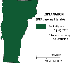
Map of Vermont showing status of 3D Elevation Program (3DEP) baseline lidar data as of November 2024. Visit https://usgs.gov/NationalMap/LidarExplorer to find and download currently available data.
Table 2.
Conservative benefits estimates for the top eight Vermont business uses of the proposed 3D Elevation Program data identified in the National Enhanced Elevation Assessment (Dewberry, 2012).Status of 3DEP in Vermont
With the completion of the statewide baseline quality level 2 dataset, there is now an emerging need for lidar data of even higher resolution and frequency. Use of existing data suggests that the annual benefits would increase if quality level 1 lidar data were available for critical business uses in Vermont. Statewide quality level 1 lidar data are expected to be available in the third quarter of 2025. In addition, high-resolution bathymetric lidar data are very important for managing Vermont’s waterways. With a surface area of 435 square miles and nearly 600 miles of shoreline in Vermont, New York, and Quebec, Lake Champlain is the most important surface-water feature in Vermont and is an economic driver in the region. For similar reasons, the Connecticut River and the many other lakes and ponds in Vermont would also benefit from high-resolution bathymetric lidar data coupled with the existing statewide quality level 2 lidar foundation.
Geologic Resource Assessment and Hazard Mitigation
Because Vermont contains the headwaters of numerous rivers, the State experiences landslides throughout all its physiographic provinces. Lidar provides detailed bare-earth elevation data, even in densely vegetated areas, that enhances surficial geologic mapping used for the identification of landslides (fig. 2), sinkholes, and blind valleys, and for geologic resource assessments such as the identification of sand and gravel deposits.
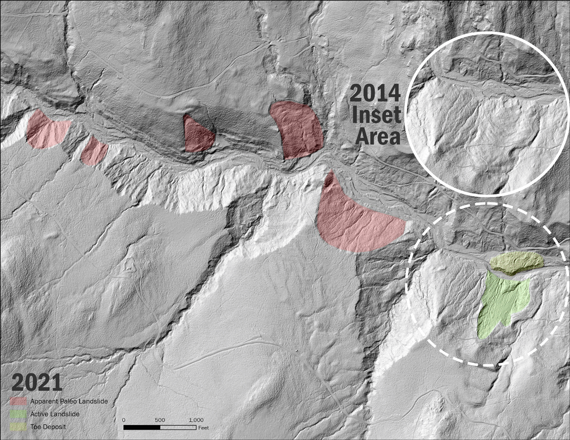
Graphic shows how lidar bare-earth hillshade enables geologists to delineate paleo- landslide scarps (red), which are otherwise invisible on orthophotos or topographic maps in heavily forested areas. Active and apparent paleo landslides are shown in 2021 (2014 inset shows no activity) along Cotton Brook, Mount Mansfield State Forest, Vermont. An active landslide and associated toe deposit in 2021 are depicted in green and yellow, respectively. Image courtesy of Tim Terway, Vermont Center for Geographic Information, and Julia Boyles, Vermont Geological Survey
Flood Risk Management
Lidar data provide high-quality terrain information as input for more accurate and less expensive hydrologic and hydraulic modeling for flood studies, retention dam design, dam breach studies, and stormwater management and engineering. Lidar data also are useful in identifying vulnerable properties within a flood plain, facilitating better flood-plain management decisions and educating the public on true flood risks, and creating dynamic three-dimensional models to show the potential effects of flooding.
Natural Resources Conservation
High-resolution elevation data enable State, regional, and local governments to effectively implement natural resources conservation practices such as grade stabilization, dam safety oversight, provision of habitat easements, situating of pipelines, terracing, wetland restoration, identification of cultural features and historical (drained) wetlands. Lidar reduces the need for fieldwork, thus saving costs for governments and organizations.
Agriculture and Precision Farming
High-resolution elevation data can provide a more accurate depiction of the terrain and dramatically improve precision farming activities, which can help improve crop yields, prevent soil degradation, minimize groundwater usage, and reduce agricultural chemical runoff—factors that help farmers realize a larger return on their investments. Digital elevation models derived from lidar help with hydrologic and hydraulic modeling to identify fields that frequently flood and require extra care to avoid manure and fertilizer runoff.
“Collecting shallow-water lidar data in Lake Champlain is very important for development of more accurate hydrodynamic and wave models used in forecasting hazardous lake conditions and informing future shore-protection projects. For example, in the flood forecasting model under development many of the tributary connections at the shoreline are not very well defined in the current bathymetry data, so lidar data could help with grid development and coastal coupling of hydrodynamic and hydrologic models in those areas…New bathymetric data will also improve modeling of ice, sediment, and pollutant transport in the Lake Champlain.”— Dmitry Beletsky, Research Scientist, Cooperative Institute for Great Lakes Research (CIGLR), University of Michigan, written communication, April 20, 2021.
3D Elevation Program (3DEP)
The 3D Elevation Program is managed by the U.S. Geological Survey (USGS) on behalf of the community of Federal, State, Tribal, local, and other partners and users of elevation data. In response to growing needs for high-quality elevation data, the goal of 3DEP is to complete acquisition of nationwide light detection and ranging (lidar) data (interferometric synthetic aperture radar [IfSAR] data in Alaska) to provide the first-ever national baseline of consistent, high-resolution topographic elevation data—both bare-earth digital elevation models and 3D point clouds.
Benefits
-
• Economies of scale by acquiring data for larger areas.
-
• Predictable and flexible Federal investments that can reduce costs and allow better planning.
-
• Consistent national coverage that provides data for applications that span project, jurisdictional, and watershed boundaries.
-
• Simplified data acquisition that provides contracts, project management, quality assurance, and published data specifications.
-
• National benefits of $690 million per year conservatively, with the potential to generate $13 billion per year in additional benefits through applications that span the economy (Dewberry, 2012).
High-Quality Data and Products
3DEP lidar data provide coverage with a minimum of two points per square meter and a vertical error not to exceed 10 centimeters, measured as root mean square error in the elevation (z) dimension (RMSEz) (table 1). 3DEP baseline lidar data products include all data points collected (point clouds) and bare-earth digital elevation models with a 1-meter or better resolution. The USGS integrates the elevation data into The National Map. Data are available free of charge and without use restrictions. To download 3DEP products visit https://apps.nationalmap.gov/downloader/.
Ways to Participate
Participation in 3DEP is open to Federal, State, Tribal, U.S. territorial, and local government partners, as well as private sector partners, and offers the option to acquire even higher quality data. Partners may contribute funds toward projects managed by the USGS, or they may receive cooperative funds to manage their own projects. An annual Data Collaboration Announcement is the mechanism used to establish partner agreements. Organizations and the private sector may contribute existing data that meet 3DEP requirements. For more information refer to the 3DEP website at https://www.usgs.gov/3DEP/collaborate/.
References Cited
Dewberry, 2012, National Enhanced Elevation Assessment final report (revised March 29, 2012): Fairfax, Va., Dewberry, 84 p. plus appendixes, accessed October 7, 2024 at https://www.dewberry.com/services/geospatial/national-enhanced-elevation-assessment.
Heidemann, H.K., 2012, Lidar base specification (ver. 1.2, November 2014): U.S. Geological Survey Techniques and Methods, book 11, chap. B4, 67 p. with appendixes, accessed October 7, 2024 at https://doi.org/10.3133/tm11B4.
Sugarbaker, L.J., Constance, E.W., Heidemann, H.K., Jason, A.L., Lukas, V., Saghy, D.L., and Stoker, J.M., 2014, The 3D Elevation Program initiative—A call for action: U.S. Geological Survey Circular 1399, 35 p., accessed October 7, 2024 at https://doi.org/10.3133/cir1399.
For Further Information:
Director, National Geospatial Program
U.S. Geological Survey, MS 511
12201 Sunrise Valley Drive
Reston, VA 20192
Email: [email protected]
USGS National Map Liaison: https://www.usgs.gov/ngp-user-engagement-office
Disclaimers
Any use of trade, firm, or product names is for descriptive purposes only and does not imply endorsement by the U.S. Government.
Although this information product, for the most part, is in the public domain, it also may contain copyrighted materials as noted in the text. Permission to reproduce copyrighted items must be secured from the copyright owner.
Suggested Citation
Walters, D., 2025, The 3D Elevation Program—Supporting Vermont's economy: U.S. Geological Survey Fact Sheet 2025–3033, 2 p., https://doi.org/10.3133/fs20253033.
ISSN: 2327-6932 (online)
Study Area
| Publication type | Report |
|---|---|
| Publication Subtype | USGS Numbered Series |
| Title | The 3D Elevation Program—Supporting Vermont's economy |
| Series title | Fact Sheet |
| Series number | 2025-3033 |
| DOI | 10.3133/fs20253033 |
| Publication Date | July 15, 2025 |
| Year Published | 2025 |
| Language | English |
| Publisher | U.S. Geological Survey |
| Publisher location | Reston, VA |
| Contributing office(s) | National Geospatial Program |
| Description | 2 p. |
| Country | United States |
| State | Vermont |
| Online Only (Y/N) | Y |
| Additional Online Files (Y/N) | N |