

The 3D Elevation Program—Supporting Louisiana’s Economy
Links
- Document: Report (1.02 MB pdf) , HTML , XML
- Download citation as: RIS | Dublin Core
Introduction
Recent and ongoing collections of high-resolution elevation data in Louisiana are providing information that supports improved critical public safety modeling and enables the State to strengthen its efforts to fight the effects of land subsidence and sea-level rise. The availability of current and accurate three-dimensional (3D) elevation data supports numerous business activities, including flood risk management, infrastructure and construction management, coastal zone management, wildlife and habitat management, recreation, agriculture and precision farming, urban and regional planning, water supply and quality assessment, and natural resources conservation. Critical applications that meet the State’s management needs depend on light detection and ranging (lidar) data that provide a highly detailed 3D model of the Earth’s surface and aboveground features.
The 3D Elevation Program (3DEP; refer to sidebar) is managed by the U.S. Geological Survey (USGS) in partnership with Federal, State, Tribal, U.S. territorial, and local agencies to acquire consistent lidar coverage at quality level 2 or better (table 1) to meet the many needs of the Nation and Louisiana. The status of available and in-progress 3DEP baseline lidar data in Louisiana is shown in figure 1. 3DEP baseline lidar data include quality level 2 or better, 1-meter or better digital elevation models, and lidar point clouds, and must meet the Lidar Base Specification version 1.2 (https://www.usgs.gov/3dep/lidarspec) or newer requirements. The National Enhanced Elevation Assessment (Dewberry, 2012) identified user requirements and conservatively estimated that availability of lidar data would result in at least $6.96 million in new benefits annually to the State. The top 10 Louisiana business uses for 3D elevation data, which are based on the estimated annual conservative benefits of 3DEP, are shown in table 2.
Table 1.
Data quality levels, pulse spacing, and pulse density. Quality level 2 or better lidar data meet 3DEP requirements.[Specifications for quality level 0 (QL0) are from Heidemann (2012, p. 3 and table 1); for quality levels 1 and 2, specifications are from Sugarbaker and others (2014, table 1). In the quality level column, QL0 represents the highest level of quality. RMSEz, root mean square error in the elevation (z) dimension; cm, centimeter; m, meter; pls/m2, first return pulses per square meter; ≤, less than or equal to; ≥, greater than or equal to]
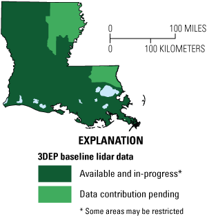
Map of Louisiana showing status of 3D Elevation Program (3DEP) baseline lidar data as of November 2024. Visit https://usgs.gov/NationalMap/LidarExplorer to find and download currently available data.
Table 2.
Conservative benefits estimates for the top 10 Louisiana business uses of the proposed 3DEP data identified in the National Enhanced Elevation Assessment (Dewberry, 2012).Status of 3DEP in Louisiana
High-density lidar data are the primary sources for deriving elevation models and other datasets. Historic flooding throughout Louisiana in 2016, during which 13 lives were lost and approximately 158,000 homes were damaged, prompted the State to assess how it prepares for increasingly frequent flood events (Louisiana Watershed Cooperating Agencies, 2018, p. II-4). The Louisiana Watershed Initiative, announced by Governor John Bel Edwards in September 2018 (Louisiana Watershed Initiative, 2018), is addressing improvements in flood risk management. Louisiana is pursuing a statewide collection of quality level 1 lidar in coordination with State, local, and Federal partners to support data needs of the initiative.
Flood Risk Management
Much of Louisiana consists of land created by the Mississippi River Delta. Inland topography and nearshore bathymetry are very important to Louisiana because of its role as a major transportation hub linking railroads, highways, and ports that serve the country. Louisiana’s coastal lands also serve the Nation by supplying energy, seafood, and numerous other food products. The dynamic nature of the delta system causes continuous change in local topography and the land-water interface. This ever-changing coast creates challenges in maintaining infrastructure, providing a safe living environment, and supporting the state and national economies. To address coastal land loss, Louisiana has developed its Comprehensive Master Plan for a Sustainable Coast (Louisiana Coastal Protection and Restoration Authority, 2023), featuring major coastal engineering projects designed to mitigate shoreline loss in local areas. High-resolution elevation datasets that meet 3DEP requirements are essential for long-term flood risk reduction modeling, coastal restoration and protection, and land change studies.
Infrastructure and Construction Management
The Louisiana Department of Transportation and Development (LaDOTD) has a requirement for quality level 1 lidar data for business uses, including transportation design and planning, flood modeling, emergency response and damage assessment, topographic mapping, and infrastructure management and protection. The agency established the Statewide Topographic Mapping Program, including an Open Data Portal (https://data-ladotd.opendata.arcgis.com), to work with local, State, and Federal agencies and private industry to facilitate the interoperability of geospatial data. Lidar data collected through this program adhere to the Lidar Base Specification and meet a broad range of planning and design applications at LaDOTD, including site selection, terrain modeling, flood-plain mapping, and drainage assessment.
Sea-level Rise and Subsidence
The vulnerability of human populations and infrastructure to projected increases in sea level is a critical area of uncertainty for communities in the extremely low-lying and flat northern Gulf of America coastal zone. Because elevation is the primary factor that determines the vulnerability of coastal regions to inundation from sea-level rise, accurate high-resolution digital elevation models that rely heavily on airborne lidar are needed. Quality level 1 data are essential to discriminate between small changes in elevation that can render a location safe for use or uninhabitable (fig. 2).
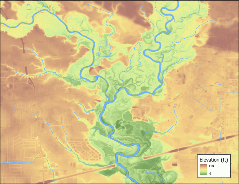
Digital elevation model (DEM) of a portion of the Amite River basin in southeastern Louisiana, showing elevation in feet above sea level. Following historic flooding in 2016, lidar was collected for nearly 1,200 miles of rivers, creeks, canals, and bayous within the Amite River basin. These data are being used by engineers, scientists, and planners to support Louisiana’s Comprehensive Master Plan for a Sustainable Coast and to quantify potential watershed-scale impacts of flood control projects, developments, and plans. Graphic courtesy of Louisiana Department of Transportation and Development.
3D Elevation Program (3DEP)
The 3D Elevation Program is managed by the U.S. Geological Survey (USGS) on behalf of the community of Federal, State, Tribal, local, and other partners and users of elevation data. In response to growing needs for high-quality elevation data, the goal of 3DEP is to complete acquisition of nationwide light detection and ranging (lidar) data (interferometric synthetic aperture radar [IfSAR] data in Alaska) to provide the first-ever national baseline of consistent, high-resolution topographic elevation data—both bare-earth digital elevation models and 3D point clouds.
Benefits
-
• Economies of scale by acquiring data for larger areas.
-
• Predictable and flexible Federal investments that can reduce costs and allow better planning.
-
• Consistent national coverage that provides data for applications that span project, jurisdictional, and watershed boundaries.
-
• Simplified data acquisition that provides contracts, project management, quality assurance, and published data specifications.
-
• National benefits of $690 million per year conservatively, with the potential to generate $13 billion per year in additional benefits through applications that span the economy (Dewberry, 2012).
High-Quality Data and Products
3DEP lidar data provide coverage with a minimum of two points per square meter and a vertical error not to exceed 10 centimeters, measured as root mean square error in the elevation (z) dimension (RMSEz) (table 1). 3DEP baseline lidar data products include all data points collected (point clouds) and bare-earth digital elevation models with a 1-meter or better resolution. The USGS integrates the elevation data into The National Map. Data are available free of charge and without use restrictions. To download 3DEP products visit https://apps.nationalmap.gov/downloader/.
Ways to Participate
Participation in 3DEP is open to Federal, State, Tribal, U.S. territorial, and local government partners, as well as private sector partners, and offers the option to acquire even higher quality data. Partners may contribute funds toward projects managed by the USGS, or they may receive cooperative funds to manage their own projects. An annual Data Collaboration Announcement is the mechanism used to establish partner agreements. Organizations and the private sector may contribute existing data that meet 3DEP requirements. For more information refer to the 3DEP website at https://www.usgs.gov/3DEP/collaborate/.
References Cited
Dewberry, 2012, Final report of the National Enhanced Elevation Assessment (revised March 29, 2012): Fairfax, Va., Dewberry, 84 p. plus appendixes, accessed October 26, 2023, at https://www.dewberry.com/services/geospatial/national-enhanced-elevation-assessment.
Heidemann, H.K., 2012, Lidar base specification (ver. 1.2, November 2014): U.S. Geological Survey Techniques and Methods, book 11, chap. B4, 67 p. with appendixes, accessed October 26, 2023, at https://doi.org/10.3133/tm11B4.
Louisiana Coastal Protection and Restoration Authority, 2023, Louisiana’s Comprehensive Master Plan for a Sustainable Coast, 4th ed.: Louisiana Coastal Protection and Restoration Authority website, accessed October 26, 2023, at https://coastal.la.gov/our-plan/2023-coastal-master-plan/.
Louisiana Watershed Cooperating Agencies, 2018, Phase I Investigation, Louisiana Statewide Comprehensive Watershed-based Floodplain Management Program, May 2018: Louisiana Watershed Cooperating Agencies report, 320 p., accessed October 26, 2023, at https://watershed.la.gov/assets/docs/Phase-1-Full-Report-with-Appendices_compressed.pdf: Louisiana Watershed Initiative, 2018, Creating a more resilient Louisiana: Louisiana Watershed Initiative website, accessed October 26, 2023, at https://www.watershed.la.gov.
Sugarbaker, L.J., Constance, E.W., Heidemann, H.K., Jason, A.L., Lukas, V., Saghy, D.L., and Stoker, J.M., 2014, The 3D Elevation Program initiative—A call for action: U.S. Geological Survey Circular 1399, 35 p., accessed October 26, 2023, at https://doi.org/https://doi.org/10.3133/cir1399.
For Further Information:
Director, National Geospatial Program
U.S. Geological Survey, MS 511
12201 Sunrise Valley Drive
Reston, VA 20192
Email: [email protected]
USGS National Map Liaison:
Disclaimers
Any use of trade, firm, or product names is for descriptive purposes only and does not imply endorsement by the U.S. Government.
Although this information product, for the most part, is in the public domain, it also may contain copyrighted materials as noted in the text. Permission to reproduce copyrighted items must be secured from the copyright owner.
Suggested Citation
Cretini, C., 2025, The 3D Elevation Program—Supporting Louisiana's economy: U.S. Geological Survey Fact Sheet 2025–3034, 2 p., https://doi.org/10.3133/fs20253034.
ISSN: 2327-6932 (online)
Study Area
| Publication type | Report |
|---|---|
| Publication Subtype | USGS Numbered Series |
| Title | The 3D Elevation Program—Supporting Louisiana's economy |
| Series title | Fact Sheet |
| Series number | 2025-3034 |
| DOI | 10.3133/fs20253034 |
| Publication Date | July 09, 2025 |
| Year Published | 2025 |
| Language | English |
| Publisher | U.S. Geological Survey |
| Publisher location | Reston, VA |
| Contributing office(s) | National Geospatial Program |
| Description | 2 p. |
| Country | United States |
| State | Louisiana |
| Online Only (Y/N) | Y |
| Additional Online Files (Y/N) | N |