

Applying U.S. Geological Survey Science to Understand Effects to Water Supply in the Upper Colorado River Basin
Links
- Document: Report (5.93 MB pdf) , XML
- Related Work: FS 2025-3039 U.S. Geological Survey Streamgage Network in the Upper Colorado River Basin—Recording the Hydrologic History of the Western United States
- NGMDB Index Page: National Geologic Map Database Index Page (html)
- Download citation as: RIS | Dublin Core
Plain Language Summary
The U.S. Geological Survey (USGS) cooperates with resource managers, municipalities, tribes, and local, State, and Federal agencies to help improve understanding of processes potentially affecting water supply in the Colorado River Basin. This fact sheet describes three key potential factors affecting water supply in the upper portion of the basin—snow processes and water storage, wildfire and basin hydrology, and salinity concentrations and water quality—and highlights associated USGS research activities in the basin. The Colorado River Basin is an important water source for more than 40 million people in the Western United States and Mexico, providing water to major cities and irrigating agricultural land. However, since 2000, the region has faced prolonged drought conditions, leading to record low levels in Lake Mead and Lake Powell and resulting in water usage restrictions. The USGS plays a key role in studying the Colorado River Basin water supply. Understanding the processes that can affect water supply in the upper portion of the basin could be crucial for supporting human, agricultural, and ecological needs across a large spatial scale.
Introduction
The Colorado River Basin is a vital source of water to more than 40 million people in the Western United States and Mexico, including in major cities like Denver, Las Vegas, Phoenix, Tucson, Los Angeles, and San Diego, and supports irrigation for about 16,000 square kilometers of agricultural land (Evenson and others, 2018). Since 2000, the southwestern United States has been unusually dry due to low precipitation and warm air temperatures, contributing to extreme water level declines of the two large reservoirs on the Colorado River, Lake Mead and Lake Powell. In 2021, these reservoirs reached their lowest levels on record, resulting in unprecedented restrictions on water usage in the basin (Williams and others, 2022). As much as 90 percent of the annual runoff in the Colorado River Basin originates in areas upstream from Lake Powell (hereafter, these areas will be referred to collectively as the “Upper Basin”; Christensen and others, 2004; fig. 1). Consequently, understanding the processes that can affect water supply in the Upper Basin could be crucial for supporting human, agricultural, and ecological needs across a large spatial scale.
The U.S. Geological Survey (USGS) does a wide variety of science in cooperation with resource managers, municipalities, tribes, and local, State, and Federal agencies to help improve understanding of processes, such as streamflow and water quality, potentially affecting water supply in the Upper Basin. This fact sheet describes three key potential factors affecting water supply in the Upper Basin—snow processes and water storage, wildfire and basin hydrology, and salinity concentrations and water quality—and highlights associated USGS research activities in the basin.
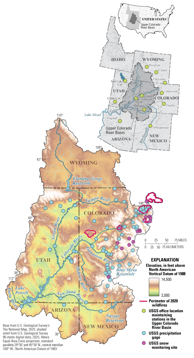
Map of the Upper Colorado River Basin showing the elevation range and perimeter of 2020 wildfires (MTBS, 2025) and locations of U.S. Geological Survey (USGS) offices, precipitation gages, and snow monitoring sites (USGS, 2025d).
Snow Processes and Water Storage
In high-elevation, mountainous regions of Colorado and Wyoming, most precipitation falls as snow, which accumulates in seasonal snowpacks that serve as a vast natural reservoir. Spring snowmelt is stored and released from a network of large artificial reservoirs (fig. 1) within the Upper Basin to support water supply needs later in the year. Variability in annual snowpack amounts and factors affecting spring runoff, such as air temperature, snow water equivalent, runoff rates, and dust on snow, can substantially affect streamflow yields and ultimately water supply throughout the Colorado River Basin (USGS, 2025a).
The USGS established a snow hydrology monitoring network in 2021 to aid investigations of snowpack and snowmelt dynamics in the Upper Basin (USGS, 2025c). Sites in the network (fig. 1) are in areas previously underrepresented by existing snow monitoring networks, including low- to mid- and high-elevation sites, allowing for better characterization of hydrologic conditions in the Upper Basin. To support snow-related studies, regular data collection occurs at network locations, including continuous measurements of snowpack characteristics, soil moisture, and meteorological parameters, and annual manual snowpack surveys (fig. 2A, B). The USGS uses uncrewed aircraft systems to create maps of snowpack conditions with remote sensing to better characterize conditions without using on-the-ground monitoring (fig. 2C). These data are used by the USGS and cooperators to better understand how annual snowpack changes and affects streamflow timing, magnitude, and duration (USGS, 2025a).
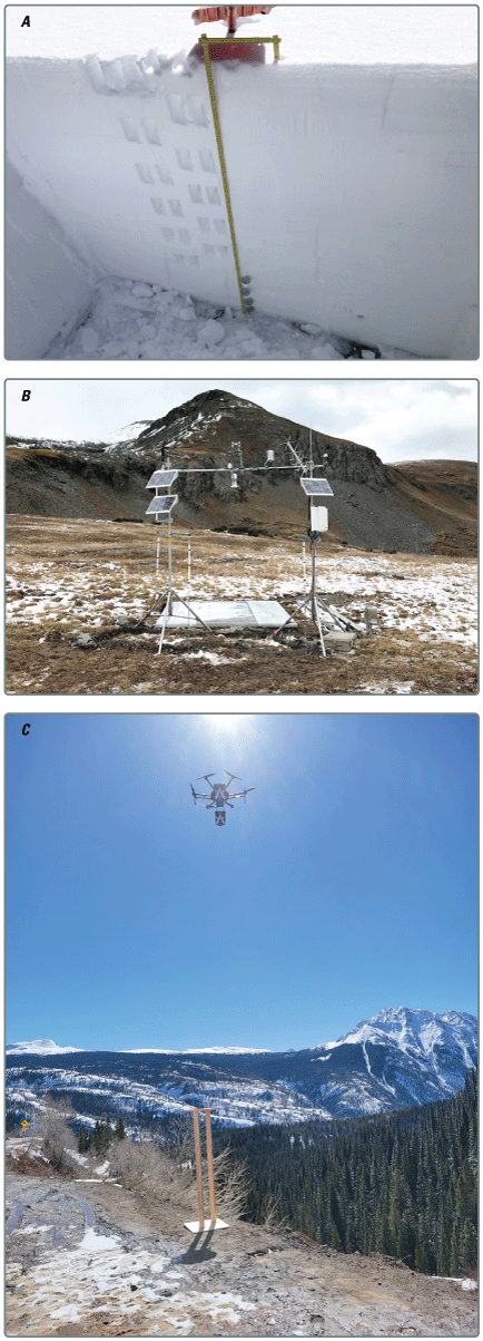
A, Snow water equivalent and temperature profile measurements in a snow pit; B, a site in the U.S. Geological Survey snow hydrology monitoring network; and C, an uncrewed aircraft system making remote sensing measurements of snow depth and snow density. Photographs by the U.S. Geological Survey.
The USGS also investigates the factors affecting streamflow yields reaching reservoirs and conditions potentially affecting water-supply management. Lake Powell represents the hydrological integrator of all incoming streamflow from the Upper Basin (fig. 1). Beginning in 2017, the USGS completed topobathymetric surveys of Lake Powell and updated the elevation-area-capacity relations for the first time since 1986 (Root and Jones, 2022). These surveys highlight changes in reservoir storage and its relation with sediment transport throughout the lifespan of Lake Powell and provide a foundational context for further water-availability investigations in the Upper Basin.
Wildfire and Basin Hydrology
Warming temperatures, earlier snowmelt, and ongoing drought in the Western United States have contributed to an increasing prevalence of large, destructive wildfires since the 1980s (Parks and Abatzoglou, 2020). In addition to posing a direct risk to humans, animals, and property, these fires can have long-lasting effects on a wide range of hydrological process. For example, wildfires can affect drinking water quality and aquatic ecosystems from the erosion and transport of sediment, ash, nutrients, and carbon from burned hillslopes into streams, lakes, and reservoirs (Rhoades and others, 2019). Loss of vegetation and changes in soil properties, like infiltration and water repellency, can lead to changes in snowpack dynamics and streamflow yields (Williams and others, 2022). After large precipitation events before soil and vegetation recovery, extensive sediment transport and geomorphic changes can occur. These fire-flood sequences are exacerbated by the increasing intensity of precipitation events in the Western United States, in combination with wildfire severity and frequency (Sanderson and others, 2019).
In 2020, Colorado experienced its worst wildfire season on record with more than 600,000 acres burned (fig. 1, 3). The USGS investigated the effects of these fires on public safety, water supply, and runoff processes. These investigations include studies evaluating drinking water quality (Clow and others, 2024), native fish populations effects (Wells and others, 2024), snowpack response (Reis and others, 2024), and a precipitation monitoring network to support an early warning system for flooding and debris flows along Interstate 70 in central Colorado (USGS, 2025b).
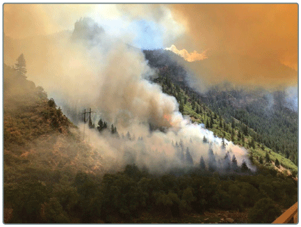
Grizzly Creek Fire burning on the slopes above the Colorado River in 2020. Photograph from Inciweb (https://inciweb.wildfire.gov/).
Salinity Concentrations and Water Quality
Salinity concentrations, measured as total dissolved solids, impair water supply in the Colorado River Basin, causing an estimated $400 million in annual economic damage because of corrosion of infrastructure, water treatment costs, and reduced agricultural yields (Colorado River Basin Salinity Control Forum, 2020). The Upper Basin contributes a majority of the more than 7 million metric tons of dissolved solids that flow past Hoover Dam each year, primarily because of the availability of soluble minerals in geologic formations in the basin. Natural erosion processes and saline springs (fig. 4A) contribute some salinity, and a substantial amount comes from irrigated agricultural land (Miller and others, 2017). Unlined irrigation canals and excess application of water to fields leach dissolved solids from soils (fig. 4B). Salinity control measures targeting irrigation system improvements, including canal lining and more efficient irrigation techniques, can mediate salinity availability (Colorado River Basin Salinity Control Forum, 2020).
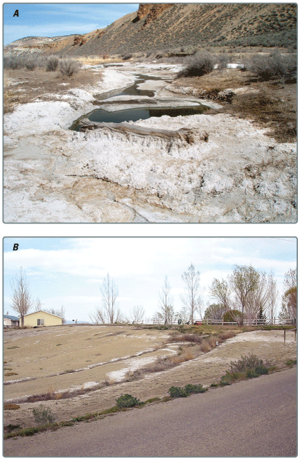
A, saline spring in Colorado, and B, irrigated field with salt residue. Photographs by the U.S. Geological Survey.
The USGS cooperates with stakeholders to identify potential sources of salinity, assess the effectiveness of control activities, evaluate long-term salinity trends throughout the Upper Basin, and characterize how changes in land management and use can affect salinity loading in rivers. For example, USGS analyses are used to assess the effectiveness of salinity control measures (Butler, 2001; Mast, 2017). Analyses of land use, land cover, climate, and reservoir datasets throughout the last century have identified potential drivers of observed salinity change and are used to inform salinity mitigation efforts at large basin scales (Miller and others, 2017) and smaller, subbasin scales (Richards, 2014).
Summary
The Colorado River Basin is an important water source for more than 40 million people in the Western United States and Mexico, providing water to major cities and irrigating a substantial amount of agricultural land. However, since 2000, the region has faced prolonged drought conditions, leading to record low levels in Lake Mead and Lake Powell and resulting in substantial water usage restrictions. The U.S. Geological Survey (USGS) plays an essential role in studying the Upper Colorado River Basin water supply, focusing on key factors such as snow processes, wildfires effects, and elevated salinity concentrations. Snowpacks, which act as natural reservoirs, are monitored to understand their effect on streamflow. The increasing prevalence of wildfires alters hydrological processes, affecting water quality and snowpack dynamics. Elevated salinity concentrations from natural and agricultural runoff pose economic challenges to water supply, and the results of USGS scientific investigations inform resource management decisions regarding salinity control. Through these efforts, the USGS aims to enhance understanding of water supply dynamics in the Upper Colorado River Basin to support human, agricultural, and ecological needs.
References Cited
Butler, D.L., 2001, Effects of piping irrigation laterals on selenium and salt loads, Montrose Arroyo Basin, western Colorado: U.S. Geological Survey Water-Resources Investigation Report, 2001–4204, 14 p., accessed January 5, 2025, at https://doi.org/10.3133/wri014204.
Christensen, N.S., Wood, A.W., Voisin, N., Lettenmaier, D.P., and Palmer, R.N., 2004, The effects of climate change on the hydrology and water resources of the Colorado River Basin: Climatic Change, v. 62, no. 1, p. 337–363, accessed February 10, 2025, at https://doi.org/10.1023/B:CLIM.0000013684.13621.1f.
Clow, D.W., Akie, G.A., Murphy, S.F., and Gohring, E.J., 2024, Dynamic water-quality responses to wildfire in Colorado: Hydrological Processes, v. 38, no. 10, art. e15291, 19 p., accessed January 25, 2025, at https://doi.org/10.1002/hyp.15291.
Colorado River Basin Salinity Control Forum, 2020, 2020 Review—Water quality standards for salinity, Colorado River system: Colorado River Basin States [States of Arizona, California, Colorado, Nevada, New Mexico, Utah, and Wyoming], 97 p, prepared by Colorado River Basin Salinity Control Forum, accessed October 2020 at https://www.coloradoriversalinity.org/docs/2020%20REVIEW%20-%20Final%20w%20appendices.pdf.
Evenson, E.J., Jones, S.A., Barber, N.L., Barlow, P.M., Blodgett, D.L., Bruce, B.W., Douglas-Mankin, K.R., Farmer, W.H., Fischer, J.M., Hughes, W.B., Kennen, J.G., Kiang, J.E., Maupin, M.A., Reeves, H.W., Senay, G.B., Stanton, J.S., Wagner, C.R., and Wilson, J.T., 2018, Continuing progress toward a national assessment of water availability and use: U.S. Geological Survey Circular 1440, 64 p., accessed January 10, 2025, at https://doi.org/10.3133/cir1440.
Mast, M.A., 2017, Estimation of salt loads for the Dolores River in the Paradox Valley, Colorado, 1980–2015: U.S. Geological Survey Scientific Investigations Report 2017–5059, 20 p., accessed December 15, 2024, at https://doi.org/10.3133/sir20175059.
Miller, M.P., Buto, S.G., Lambert, P.M., and Rumsey, C.A., 2017, Enhanced and updated spatially referenced statistical assessment of dissolved-solids load sources and transport in streams of the Upper Colorado River Basin: U.S. Geological Survey Scientific Investigations Report 2017–5009, 23 p., accessed December 20, 2024, at https://doi.org/10.3133/sir20175009.
Monitoring Trends in Burn Severity [MTBS], 2025, Burned areas boundaries dataset: MTBS web page, accessed February 15, 2025, at https://www.mtbs.gov/direct-download.
Parks, S.A., and Abatzoglou, J.T., 2020, Warmer and drier fire seasons contribute to increases in area burned at high severity in Western U.S. forests from 1985 to 2017: Geophysical Research Letters, v. 47, no. 22, art. e2020GL089858, 10 p., accessed January 20, 2025, at https://doi.org/10.1029/2020GL089858.
Reis, W., McGrath, D., Elder, K., Kampf, S., and Rey, D., 2024, Quantifying aspect-dependent snowpack response to high-elevation wildfire in the Southern Rocky Mountains: Water Resources Research, v. 60, no. 9, art. e2023WR036539, 21 p., accessed January 20, 2025, at https://doi.org/10.1029/2023WR036539.
Rhoades, C.C., Chow, A.T., Covino, T.P., Fegel, T.S., Pierson, D.N., and Rhea, A.E., 2019, The legacy of a severe wildfire on stream nitrogen and carbon in headwater catchments: Ecosystems, v. 22, no. 3, p. 643–657, at https://doi.org/10.1007/s10021-018-0293-6.
Richards, R.J., 2014, Characterization of salinity loads and selenium loads in the Smith Fork Creek region of the lower Gunnison River Basin, western Colorado, 2008–2009: Scientific Investigations Report 2014–5101, 34 p., accessed January 25, 2025, at https://pubs.usgs.gov/sir/2014/5101/.
Root, J.C., and Jones, D.K., 2022, Elevation-area-capacity relationships of Lake Powell in 2018 and estimated loss of storage capacity since 1963: U.S. Geological Survey Scientific Investigations Report 2022–5017, 21 p., accessed January 10, 2025, at https://doi.org/10.3133/sir20225017.
Sanderson, B.M., Wobus, C., Mills, D., Zarakas, C., Crimmins, A., Sarofim, M.C., and Weaver, C., 2019, Informing future risks of record-level rainfall in the United States: Geophysical Research Letters, v. 46, no. 7, p. 3963–3972, accessed February 25, 2025, at https://doi.org/10.1029/2019GL082362.
U.S. Geological Survey [USGS], 2025a, From snow to flow—What changing snowmelt means for water in the Western U.S.: U.S. Geological Survey webpage, accessed May 5, 2025, at https://labs.waterdata.usgs.gov/visualizations/snow-to-flow/index.html#/.
U.S. Geological Survey [USGS], 2025b, Glenwood Canyon flooding and debris flows: U.S. Geological Survey website, accessed May 2, 2025, at https://landslides.usgs.gov/storymap/grizzlycreek/.
U.S. Geological Survey [USGS], 2025c, Regional water availability assessment—Upper Colorado River Basin: U.S. Geological Survey web page, accessed May 3, 2025, at https://www.usgs.gov/mission-areas/water-resources/science/regional-water-availability-assessment-upper-colorado-river.
U.S. Geological Survey [USGS], 2025d, U.S. Geological Survey USGS water data for the Nation: U.S. Geological Survey National Water Information System database, accessed February 15, 2025, at https://doi.org/10.5066/F7P55KJN.
Wells, A.G., Yackulic, C.B., Kostelnik, J., Bock, A., Zuellig, R.E., Carlisle, D.M., Roberts, J.J., Rogers, K.B., and Munson, S.M., 2024, Before the fire—Predicting burn severity and potential post-fire debris-flow hazards to conservation populations of the Colorado River Cutthroat Trout (Oncorhynchus clarkii pleuriticus): International Journal of Wildland Fire, v. 33, no. 11, 19 p., accessed April 10, 2025, at https://doi.org/10.1071/WF23199.
Williams, A.P., Livneh, B., McKinnon, K.A., Hansen, W.D., Mankin, J.S., Cook, B.I., Smerdon, J.E., Varuolo-Clarke, A.M., Bjarke, N.R., Juang, C.S., and Lettenmaier, D.P., 2022, Growing impact of wildfire on Western U.S. water supply: Proceedings of the National Academy of Sciences, v. 119, no. 10, art. e2114069119, 8 p., accessed January 18, 2025, at https://doi.org/10.1073/pnas.2114069119.
For More Information:
Visit the Colorado Water Science Center website at
Disclaimers
Any use of trade, firm, or product names is for descriptive purposes only and does not imply endorsement by the U.S. Government.
Although this information product, for the most part, is in the public domain, it also may contain copyrighted materials as noted in the text. Permission to reproduce copyrighted items must be secured from the copyright owner.
Suggested Citation
Day, N.K., and Williams, C.A., 2025, Applying U.S. Geological Survey science to understand effects to water supply in the Upper Colorado River Basin: U.S. Geological Survey Fact Sheet 2025-3036, 4 p., https://doi.org/10.3133/fs20253036.
ISSN: 2327-6932 (online)
ISSN: 2327-6916 (print)
Study Area
| Publication type | Report |
|---|---|
| Publication Subtype | USGS Numbered Series |
| Title | Applying U.S. Geological Survey science to understand effects to water supply in the Upper Colorado River Basin |
| Series title | Fact Sheet |
| Series number | 2025-3036 |
| DOI | 10.3133/fs20253036 |
| Publication Date | August 05, 2025 |
| Year Published | 2025 |
| Language | English |
| Publisher | U.S. Geological Survey |
| Publisher location | Reston VA |
| Contributing office(s) | Colorado Water Science Center |
| Description | 4 p. |
| Country | United States |
| State | Arizona, Colorado, New Mexico, Utah, Wyoming |
| Other Geospatial | Colorado River basin |
| Online Only (Y/N) | N |