

The 3D Elevation Program—Supporting Tennessee’s Economy
Links
- Document: Report (425 KB pdf) , HTML , XML
- Download citation as: RIS | Dublin Core
Introduction
The State of Tennessee has an area of approximately 42,100 square miles and includes six physiographic regions: Blue Ridge, Valley and Ridge, Appalachian Plateaus, Highland Rim, Nashville Basin, and the Gulf Coastal Plains. Up-to-date elevation data support key activities across the State, such as economic development, infrastructure and construction management, agriculture and precision farming, forest resources management, natural resources conservation, flood risk management, emergency management, and urban and regional planning. The State experiences frequent landslides affecting major roadways. High-resolution elevation data can help identify potential landslide-prone areas. Critical applications that meet the State’s management needs depend on light detection and ranging (lidar) data that provide a highly detailed three-dimensional (3D) model of the Earth’s surface and aboveground features.
The 3D Elevation Program (3DEP; refer to sidebar) is managed by the U.S. Geological Survey (USGS) in partnership with Federal, State, Tribal, U.S. territorial, and local agencies to acquire consistent lidar coverage at quality level 2 or better (table 1) to meet the many needs of the Nation and Tennessee. The status of available and in-progress 3DEP baseline lidar data in Tennessee is shown in figure 1. 3DEP baseline lidar data include quality level 2 or better, 1-meter or better digital elevation models, and lidar point clouds, and must meet the Lidar Base Specification version 1.2 (https://www.usgs.gov/3dep/lidarspec) or newer requirements. The National Enhanced Elevation Assessment (Dewberry, 2012) identified user requirements and conservatively estimated that availability of lidar data would result in at least $6.32 million in new benefits annually to the State. The top 10 Tennessee business uses for 3D elevation data, which are based on the estimated annual conservative benefits of 3DEP, are shown in table 2.
Table 1.
Data quality levels, pulse spacing, and pulse density. Quality level 2 or better lidar data meet 3DEP requirements.[Specifications for quality level 0 (QL0) are from Heidemann (2012, p. 3 and table 1); for quality levels 1 and 2, specifications are from Sugarbaker and others (2014, table 1). In the quality level column, QL0 represents the highest level of quality. RMSEz, root mean square error in the elevation (z) dimension; cm, centimeter; m, meter; pls/m2, first return pulses per square meter; ≤, less than or equal to; ≥, greater than or equal to]
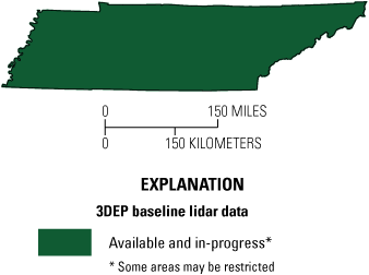
Map of Tennessee showing status of 3D Elevation Program (3DEP) baseline lidar data as of January 2025. Visit https://usgs.gov/NationalMap/LidarExplorer to find and download currently available data.
Table 2.
Conservative benefits estimates for the top 10 Tennessee business uses of the proposed 3DEP data identified in the National Enhanced Elevation Assessment (Dewberry, 2012).Status of 3DEP in Tennessee
Collection of quality level 2 3DEP lidar data is 100 percent complete in Tennessee. The success of this effort is due to strong coordination among Federal, State, and local government agencies. The Tennessee Valley Authority, U.S. Army Corps of Engineers, U.S. Department of Agriculture’s Natural Resources Conservation Service, U.S. Forest Service, and the USGS are the Federal partners. State agencies that have contributed to the USGS 3DEP effort include Transportation, Environment and Conservation, and Finance and Administration. At the local level, several counties, municipalities, utility districts, and electric co-operatives have contributed additional funding. In 2022, quality level 1 lidar data were acquired in Davidson County (Nashville area) through 3DEP to update existing quality level 2 data. The long-term plan is to update existing quality level 2 data to quality level 1 throughout the State as part of the USGS 3D Hydrography Program.
Agriculture and Precision Farming
Tennessee cash crop receipts for 2020 were $2.35 billion according to the Tennessee Department of Agriculture’s 2019–2020 Biennial Report (Tennessee Department of Agriculture, 2021). High-resolution elevation data can provide a more accurate depiction of terrain and significantly improve precision farming activities, which can help improve crop yields, prevent soil degradation, minimize groundwater usage, and reduce agricultural chemical runoff—factors that help farmers realize a larger return on their investments.
Natural Resources Conservation
High-quality elevation data enable State, Tribal, and local governments to more effectively implement natural resources conservation practices while providing additional cost savings to the public. Now that quality level 2 lidar data are available statewide, public and private organizations can expand their use of lidar for planning and site-level engineering to reduce fieldwork for conservation ponds, grassed waterways, pipelines, terracing, accurately calculating runoff, identifying historical wetlands (drained), and wetland restoration.
Flood Risk Management
The availability of more accurate statewide elevation data reduces onsite data collection costs and the amount of time required to complete flood risk project that help protect lives and property (fig. 2). The quality of analyses and study results are improved because of the more accurate elevation data. Overall, the project completion time and cost are reduced, and the savings can be applied to other priority flood risk projects.
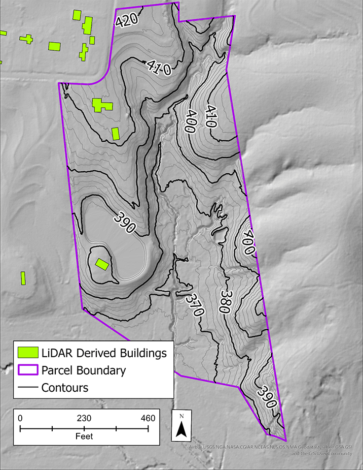
Graphic showing lidar-derived 2-foot contours, elevation models, and building footprints to help decision makers learn more about a property and whether to send a survey team or others to the site. The State of Tennessee’s engineering and mapping community uses lidar data to map land parcels (parcel boundary is outlined in purple) for economic development, feasibility assessments, construction planning, and flood assessment. Graphic courtesy of Paul Dudley, GIS Analyst, Tennessee Department of Finance and Administration.
Geologic Resource Assessment and Hazard Mitigation
The Tennessee Department of Environment and Conservation (2020) uses elevation data to conduct detailed mapping, analysis of geologic structures and stratigraphy, and assessment of mineral resources. The availability of high-quality elevation data allows for improved accuracy and detail in geologic maps and data that inform public policy and support Tennessee’s non-fuel mineral industry production, which totaled $1.46 billion in 2018.
Dense vegetation and woodlands can obscure hazardous areas. Lidar digital terrain (bare-earth) models can be used to (1) locate and assess abandoned mine lands, landscape changes related to oil and natural gas drilling, and active landslides and preexisting landslides that are susceptible to reactivation; and (2) detect sinkhole features in karst areas that have not been identified in previous elevation mapping programs. These lidar-derived data support public and environmental safety programs and the site-selection process for industry and commerce.
3D Elevation Program (3DEP)
The 3D Elevation Program is managed by the U.S. Geological Survey (USGS) on behalf of the community of Federal, State, Tribal, local, and other partners and users of elevation data. In response to growing needs for high-quality elevation data, the goal of 3DEP is to complete acquisition of nationwide light detection and ranging (lidar) data (interferometric synthetic aperture radar [IfSAR] data in Alaska) to provide the first-ever national baseline of consistent, high-resolution topographic elevation data—both bare-earth digital elevation models and 3D point clouds.
Benefits
-
• Economies of scale by acquiring data for larger areas.
-
• Predictable and flexible Federal investments that can reduce costs and allow better planning.
-
• Consistent national coverage that provides data for applications that span project, jurisdictional, and watershed boundaries.
-
• Simplified data acquisition that provides contracts, project management, quality assurance, and published data specifications.
-
• National benefits of $690 million per year conservatively, with the potential to generate $13 billion per year in additional benefits through applications that span the economy (Dewberry, 2012).
High-Quality Data and Products
3DEP lidar data provide coverage with a minimum of two points per square meter and a vertical error not to exceed 10 centimeters, measured as root mean square error in the elevation (z) dimension (RMSEz) (table 1). 3DEP baseline lidar data products include all data points collected (point clouds) and bare-earth digital elevation models with a 1-meter or better resolution. The USGS integrates the elevation data into The National Map. Data are available free of charge and without use restrictions. To download 3DEP products visit https://apps.nationalmap.gov/downloader/.
Ways to Participate
Participation in 3DEP is open to Federal, State, Tribal, U.S. territorial, and local government partners, as well as private sector partners, and offers the option to acquire even higher quality data. Partners may contribute funds toward projects managed by the USGS, or they may receive cooperative funds to manage their own projects. An annual Data Collaboration Announcement is the mechanism used to establish partner agreements. Organizations and the private sector may contribute existing data that meet 3DEP requirements. For more information refer to the 3DEP website at https://www.usgs.gov/3DEP/collaborate/.
References Cited
Dewberry, 2012, National Enhanced Elevation Assessment final report (revised March 29, 2012): Fairfax, Va., Dewberry, 84 p. plus appendixes, accessed January 13, 2025, at https://www.dewberry.com/services/geospatial/national-enhanced-elevation-assessment.
Heidemann, H.K., 2012, Lidar base specification (ver. 1.2, November 2014): U.S. Geological Survey Techniques and Methods, book 11, chap. B4, 67 p. with appendixes, accessed January 13, 2025, at https://doi.org/10.3133/tm11B4.
Sugarbaker, L.J., Constance, E.W., Heidemann, H.K., Jason, A.L., Lukas, V., Saghy, D.L., and Stoker, J.M., 2014, The 3D Elevation Program initiative—A call for action: U.S. Geological Survey Circular 1399, 35 p., accessed January 13, 2025, at https://doi.org/10.3133/cir1399.
Tennessee Department of Agriculture, 2021, Biennial report 2019–2020: Tennessee Department of Agriculture report, 20 p., accessed January 13, 2025, at https://www.tn.gov/content/dam/tn/agriculture/documents/annualreports/2021/2019-2020 BiennialReport_8.5x11 - 11.9.21.pdf.
Tennessee Department of Environment and Conservation, 2020, Tennessee’s mineral industry: Tennessee Geological Survey web page (updated January 2020), accessed January 13, 2025 at https://www.tn.gov/https://www.tn.gov/environment/program-areas/tennessee-geological-survey/geology-redirect/tennessee-s-mineral-industry.html/.
For Further Information:
Director, National Geospatial Program
U.S. Geological Survey, MS 511
12201 Sunrise Valley Drive
Reston, VA 20192
Email: [email protected]
USGS National Map Liaison:
Disclaimers
Any use of trade, firm, or product names is for descriptive purposes only and does not imply endorsement by the U.S. Government.
Although this information product, for the most part, is in the public domain, it also may contain copyrighted materials as noted in the text. Permission to reproduce copyrighted items must be secured from the copyright owner.
Suggested Citation
Heleine, G., 2025, The 3D Elevation Program—Supporting Tennessee’s economy: U.S. Geological Survey Fact Sheet 2025–3037, 2 p., https://doi.org/10.3133/fs20253037.
ISSN: 2327-6932 (online)
Study Area
| Publication type | Report |
|---|---|
| Publication Subtype | USGS Numbered Series |
| Title | The 3D Elevation Program—Supporting Tennessee’s economy |
| Series title | Fact Sheet |
| Series number | 2025-3037 |
| DOI | 10.3133/fs20253037 |
| Publication Date | July 30, 2025 |
| Year Published | 2025 |
| Language | English |
| Publisher | U.S. Geological Survey |
| Publisher location | Reston, VA |
| Contributing office(s) | National Geospatial Program |
| Description | 2 p. |
| Country | United States |
| Online Only (Y/N) | Y |
| Additional Online Files (Y/N) | N |