

The 3D Elevation Program—Supporting the Economy of Massachusetts
Links
- Document: Report (689 KB pdf) , HTML , XML
- Download citation as: RIS | Dublin Core
Introduction
Massachusetts extends from the mountains of the Appalachian system in the west of the State to the sandy beaches and rocky shorelines of the Atlantic coast in the east. Inland topographic data support a wide range of important activities, including geologic mapping, transportation planning, forest and wildlife management, quantifying ecological services, water supply protection, commonwealth-wide infrastructure planning, local site planning, and flood-plain management. Nearshore bathymetry can be used to support coastal portions of the Commonwealth by addressing the combined threats of ocean warming, strong storm surge, and rising sea levels. The maintenance and (or) expansion of Massachusetts ports (for instance, Boston, New Bedford) and Cape Cod sediment management depends upon the accurate mapping of bathymetry and the frequent influx of sediment and redeposition. Critical applications that address the broad range of requirements depend on light detection and ranging (lidar) data that provide a highly detailed three-dimensional (3D) model of the Earth’s surface and aboveground features.
The 3D Elevation Program (3DEP; refer to sidebar) is managed by the U.S. Geological Survey (USGS) in partnership with Federal, State, Tribal, U.S. territorial, and local agencies to acquire consistent lidar coverage at quality level 2 or better (table 1) to meet the many needs of the Nation and Massachusetts. The status of available and in-progress 3DEP baseline lidar data in Massachusetts is shown in figure 1. 3DEP baseline lidar data include quality level 2 or better, 1-meter or better digital elevation models, and lidar point clouds, and must meet the Lidar Base Specification version 1.2 (https://www.usgs.gov/3dep/lidarspec) or newer requirements. The National Enhanced Elevation Assessment (Dewberry, 2012) identified user requirements and conservatively estimated that availability of lidar data would result in at least $1.23 million in new benefits annually to Massachusetts. The top 10 Massachusetts business uses for 3D elevation data, which are based on the estimated annual conservative benefits of 3DEP, are shown in table 2.
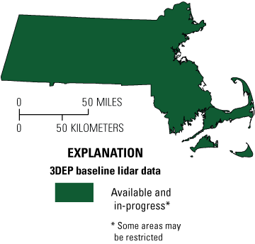
Map of Massachusetts showing status of 3D Elevation Program (3DEP) baseline lidar data as of April 2025. Visit https://usgs.gov/NationalMap/LidarExplorer to find and download currently available data.
Table 1.
Data quality levels, pulse spacing, and pulse density. Quality level 2 or better lidar data meet 3DEP requirements.[Specifications for quality level 0 (QL0) are from Heidemann (2012, p. 3 and table 1); for quality levels 1 and 2, specifications are from Sugarbaker and others (2014, table 1). In the quality level column, QL0 represents the highest level of quality. RMSEz, root mean square error in the elevation (z) dimension; cm, centimeter; m, meter; pls/m2, first return pulses per square meter; ≤, less than or equal to; ≥, greater than or equal to]
Table 2.
Conservative benefits estimates for the top 10 Massachusetts business uses of the proposed 3DEP data identified in the National Enhanced Elevation Assessment (Dewberry, 2012).Status of 3DEP in Massachusetts
Massachusetts was one of the first States to use lidar data to produce elevation products and services, starting with a 2002 acquisition project covering most of the towns in the greater Boston area. Since that time, data have been collected through a series of opportunistic cost-sharing initiatives with local entities, Federal agencies, and more recently, the 3D Elevation Program, resulting in quality level 2 lidar coverage for most of the State by 2015. Recently, higher resolution quality level 1 lidar data (fig. 2) has been flown across the entire State with the eastern region of Massachusetts having been completed in the spring of 2021 and the western half completed in 2024. Additional Massachusetts lidar information can be found at MassGIS Data: Latest and Best Quality Lidar Terrain Data Index | Mass.gov.
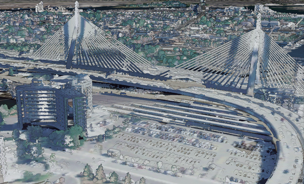
Quality level 1 lidar data collected in the spring of 2021, colorized using National Agricultural Imagery Program imagery data collected in 2016. The image depicts the Leonard P. Zakim Bunker Hill Memorial Bridge and Massachusetts General Hospital.
Flood Risk Management
The availability of high-quality elevation data can reduce onsite data-collection costs and improve the study results of a flood-risk project. Comprehensive lidar coverage enables detailed modeling, including dynamic 3D models of the overflow from streams and other bodies of water affected by large storm events, catastrophic dam failures, and coastal overland storm surges. Quality level 1 lidar data can provide an enhanced ability to predict surface-water movement and inundation along high-risk coastal areas. Communities and agencies can use this information to design improved evacuation route plans and better prepare and protect the public should a disaster strike.
Natural Resources Conservation
The Massachusetts Department of Conservation and Recreation (MDCR) manages state parks and oversees more than 450,000 acres throughout Massachusetts. It protects, promotes, and enhances the State’s natural, cultural, and recreational resources. The availability of statewide lidar data can be used for planning and site-level engineering to reduce field work for conservation projects such as grade stabilization, ponds, grassed waterways, terracing, accurately calculating runoff, habitat classification, vegetation mapping, wetland restoration, identifying historic wetlands (drained), cultural and sensitive sites, and for identifying previously unknown prehistoric and historical earthworks.
Agriculture and Precision Farming
In 2017, the Massachusetts agricultural industry provided employment to over 25,900 individuals and produced an annual market value of over $475 million in agricultural goods (Massachusetts Department of Agricultural Resources, 2022). Greenhouse and nursery, vegetables, cranberries, and milk were the top agricultural commodities. Lidar data provide a more accurate depiction of terrain and can improve precision farming activities, which can help increase crop yields, prevent soil degradation, and reduce agricultural chemical runoff—factors that can help farmers realize a larger return on their investments.
Coastal Zone Management
Mapping intertidal zone elevations, sea-floor bathymetry, upland topography, and a seamless integration of these data can support coastal zone management. Lidar has the potential to improve coastal hazards modeling, impervious surface identification and analysis, and development of resiliency plans and storm response, all of which can help protect Massachusetts’s shoreline and the fishing and tourism industries.
3D Elevation Program (3DEP)
The 3D Elevation Program is managed by the U.S. Geological Survey (USGS) on behalf of the community of Federal, State, Tribal, local, and other partners and users of elevation data. In response to growing needs for high-quality elevation data, the goal of 3DEP is to complete acquisition of nationwide light detection and ranging (lidar) data (interferometric synthetic aperture radar [IfSAR] data in Alaska) to provide the first-ever national baseline of consistent, high-resolution topographic elevation data—both bare-earth digital elevation models and 3D point clouds.
Benefits
-
• Economies of scale by acquiring data for larger areas.
-
• Predictable and flexible Federal investments that can reduce costs and allow better planning.
-
• Consistent national coverage that provides data for applications that span project, jurisdictional, and watershed boundaries.
-
• Simplified data acquisition that provides contracts, project management, quality assurance, and published data specifications.
-
• National benefits of $690 million per year conservatively, with the potential to generate $13 billion per year in additional benefits through applications that span the economy (Dewberry, 2012).
High-Quality Data and Products
3DEP lidar data provide coverage with a minimum of two points per square meter and a vertical error not to exceed 10 centimeters, measured as root mean square error in the elevation (z) dimension (RMSEz) (table 1). 3DEP baseline lidar data products include all data points collected (point clouds) and bare-earth digital elevation models with a 1-meter or better resolution. The USGS integrates the elevation data into The National Map. Data are available free of charge and without use restrictions. To download 3DEP products visit https://apps.nationalmap.gov/downloader/.
References Cited
Dewberry, 2012, National Enhanced Elevation Assessment final report (revised March 29, 2012): Fairfax, Va., Dewberry, 84 p. plus appendixes, accessed January 21, 2025, at https://www.dewberry.com/services/geospatial/national-enhanced-elevation-assessment.
Heidemann, H.K., 2012, Lidar base specification (ver. 1.2, November 2014): U.S. Geological Survey Techniques and Methods, book 11, chap. B4, 67 p. with appendixes, accessed January 21, 2025 at https://www.usgs.gov/3dep/lidarspec.
Massachusetts Department of Agricultural Resources 2022 Annual Report: Massachusetts Department of Agricultural Resources, 67 p. accessed January 21, 2025 at https://www.mass.gov/doc/mdar-annual-report-2022.
MassGIS (Bureau of Geographic Information), 2023, MassGIS Data: Latest and Best Quality Lidar Terrain Data Index, accessed January 21, 2025, at https://www.mass.gov/info-details/massgis-data-latest-and-best-quality-lidar-terrain-data-index.
Sugarbaker, L.J., Constance, E.W., Heidemann, H.K., Jason, A.L., Lukas, Vicki, Saghy, D.L., and Stoker, J.M., 2014, The 3D Elevation Program initiative—A call for action: U.S. Geological Survey Circular 1399, 35 p., accessed February 11, 2024, at http://dx.doi.org/10.3133/cir1399.
For Further Information:
Director, National Geospatial Program
12201 Sunrise Valley Drive, MS 511
Reston, VA 20192
Email: 3DEP@usgs.gov
USGS National Map Liaison:
Disclaimers
Any use of trade, firm, or product names is for descriptive purposes only and does not imply endorsement by the U.S. Government.
Although this information product, for the most part, is in the public domain, it also may contain copyrighted materials as noted in the text. Permission to reproduce copyrighted items must be secured from the copyright owner.
Suggested Citation
Walters, D., 2025, The 3D Elevation Program—Supporting the economy of Massachusetts: U.S. Geological Survey Fact Sheet 2025–3044, 2 p., https://doi.org/10.3133/fs20253044.
ISSN: 2327-6932 (online)
Study Area
| Publication type | Report |
|---|---|
| Publication Subtype | USGS Numbered Series |
| Title | The 3D Elevation Program—Supporting the economy of Massachusetts |
| Series title | Fact Sheet |
| Series number | 2025-3044 |
| DOI | 10.3133/fs20253044 |
| Publication Date | November 14, 2025 |
| Year Published | 2025 |
| Language | English |
| Publisher | U.S. Geological Survey |
| Publisher location | Reston, VA |
| Contributing office(s) | National Geospatial Program |
| Description | 2 p. |
| Country | United States |
| State | Massachusetts |
| Online Only (Y/N) | Y |
| Additional Online Files (Y/N) | Y |