

Assessment of Undiscovered Conventional and Continuous Gas Resources in the Mesaverde Group and Lance Formation in the Southwestern Wyoming Province, Wyoming, Utah, and Colorado, 2025
Links
- Document: Report (10.7 MB pdf) , HTML , XML
- Data Release: USGS data release - USGS National and Global Oil and Gas Assessment Project-Southwestern Wyoming Province, Mesaverde Group and Lance Formation Conventional and Continuous Assessment Unit Boundaries, Assessment Input Data, and Fact Sheet Data Tables
- NGMDB Index Page: National Geologic Map Database Index Page
- Download citation as: RIS | Dublin Core
Abstract
Using a geology-based assessment methodology, the U.S. Geological Survey estimated undiscovered, technically recoverable mean conventional and continuous resources of 4.7 trillion cubic feet of gas in the Mesaverde Group and Lance Formation in the Southwestern Wyoming Province, Wyoming, Utah, and Colorado.
Introduction
The U.S. Geological Survey (USGS) completed an assessment of the conventional and continuous gas resources in the Late Cretaceous Santonian to Campanian Mesaverde Group and Maastrichtian Lance Formation in the Southwestern Wyoming Province of Wyoming, Utah, and Colorado (fig. 1). The Mesaverde Group and Lance Formation are elements of the Cretaceous–Cenozoic Composite Total Petroleum System (TPS), which lies within the western half of the Southwestern Wyoming Province. The province is bounded on the west by the Wyoming salient of the Sevier orogenic belt, on the north and south by Laramide uplifts, and on the east by the pinchout of the Late Cretaceous Lewis Shale. Substantial composite TPS field production is tied to the intrabasin Laramide Pinedale Anticline and Jonah field structural features (DuBois, 2014).
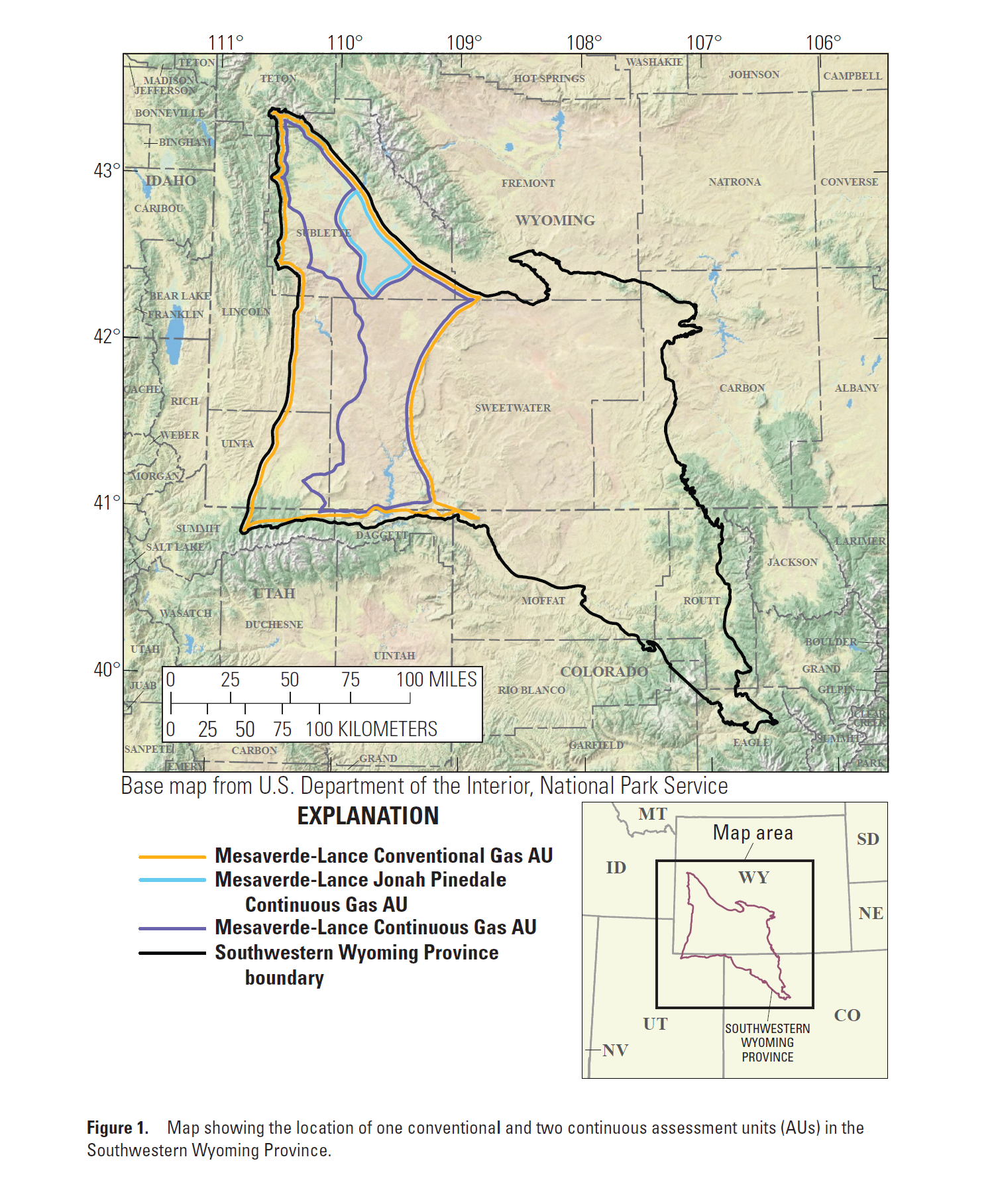
Map showing the location of one conventional and two continuous assessment units (AUs) in the Southwestern Wyoming Province.
The Cretaceous–Cenozoic Composite TPS was previously assessed by the USGS in 2005 (Finn and others, 2005), and four assessment units (AUs) were defined at that time. Three AUs were defined for this assessment, based on structural setting, source rock maturity, and production characteristics: the Mesaverde-Lance Conventional Gas AU, Mesaverde-Lance Jonah Pinedale Continuous Gas AU, and Mesaverde-Lance Continuous Gas AU (fig. 1).
Geologic Summary
The predominately gas-prone Cretaceous–Cenozoic Composite TPS consists of four Upper Cretaceous formations, which comprise alluvial, deltaic, and minor marginal marine siliciclastics, deposited roughly perpendicular to the southwest–northeast shoreline of the Western Interior Seaway (Roehler, 1990). In stratigraphic order, the formations are the Rock Springs Formation, Ericson Sandstone, and Almond Formation of the Mesaverde Group, and the Lance Formation. The primary source rocks for the composite TPS are Type III thermally mature coal beds in the Rock Springs Formation, which have a modeled vitrinite reflectance (Ro) greater than 0.8 percent (Law, 1984). Although coal beds are also present in the Ericson Sandstone and the Almond and Lance Formations, USGS thermal maturity modeling indicates they are likely too immature to contribute to hydrocarbon production, because their Ro values are less than 0.8 percent. The undifferentiated alluvial, deltaic, and marginal marine sandstone beds in the Mesaverde Group and the alluvial sandstone beds in the Lance Formation are the reservoirs for the composite TPS. However, with its more favorable porosity, permeability, and net reservoir thickness, the Lance Formation is the primary producer for the composite TPS and for the entire Southwestern Wyoming Province (DuBois, 2014; Law and Spencer, 2014; Rudolph and others, 2015).
Total Petroleum System and Assessment Units
The USGS defined one conventional and two continuous AUs within the Cretaceous–Cenozoic Composite TPS (table 1). The boundaries of the Mesaverde-Lance Conventional Gas AU are defined by Sevier- and Laramide-age uplift and depositional pinchout of the composite TPS intervals; it is the largest of the three AUs. The Mesaverde-Lance Continuous Gas AU boundaries are also defined by the same uplift and depositional pinchout features as the conventional AU on its northern, southern, and eastern boundaries; however, its western boundary is defined by the 0.8-percent modeled Ro thermal maturity line for gas in the Rock Springs Formation (fig. 1). The Mesaverde-Lance Jonah Pinedale Continuous Gas AU boundaries are defined by the structural relief and faults associated with the Pinedale Anticline and Jonah field, and the boundaries of vertical and horizontal well development, around which most of the composite TPS production is centered. Although the Mesaverde-Lance fields within the Mesaverde-Lance Conventional Gas AU are generally normally pressured and may contain gas-water contacts (Kovach and others, 2003), both continuous AUs are overpressured and lack defined gas-water contacts (Law and Spencer, 2014).
Table 1.
Key input data for one conventional and two continuous assessment units in the Mesaverde Group and Lance Formation within the Cretaceous–Cenozoic Composite Total Petroleum System in the Southwestern Wyoming Province.[Gray shading indicates not applicable. The average estimated ultimate recovery (EUR) input is the minimum, median, maximum, and calculated mean. AU, assessment unit; %, percent; BCFG, billion cubic feet of gas]
The contact between the Mesaverde-Lance Conventional Gas AU and the two continuous AUs—the Mesaverde-Lance Jonah Pinedale Continuous Gas AU and Mesaverde-Lance Continuous Gas AU—cannot be uniquely defined. Each gas field within the boundaries of the composite TPS was assigned to either a conventional or continuous AU based on its production characteristics and the absence or presence of overpressure and gas-water contacts. Assessment input data are summarized in tables 1 and 2 and Lagesse (2025).
Table 2.
Results for one conventional and two continuous assessment units in the Mesaverde Group and Lance Formation within the Cretaceous–Cenozoic Composite Total Petroleum System in the Southwestern Wyoming Province.[Gray shading indicates not applicable. Results shown are fully risked estimates. F95 represents a 95-percent chance of at least the amount tabulated; other fractiles are defined similarly. BCFG, billion cubic feet of gas; NGL, natural gas liquids; MMBNGL, million barrels of natural gas liquids]
Undiscovered Resources Summary
The USGS quantitatively assessed gas resources in one conventional and two continuous AUs in the Mesaverde Group and Lance Formation in the Southwestern Wyoming Province (tables 1, 2). The fully risked, estimated mean totals are 4,652 billion cubic feet of gas (BCFG), or 4.7 trillion cubic feet of gas, with an F95–F5 fractile range from 1,189 to 9,150 BCFG; and 158 million barrels of natural gas liquids (MMBNGL) with an F95–F5 range from 41 to 313 MMBNGL.
For More Information
Assessment results are also available at the USGS Energy Resources Program website, https://www.usgs.gov/programs/energy-resources-program.
References Cited
DuBois, D.P., 2014, Pinedale Anticline and Jonah Fields, Sublette County, Wyoming—A geologic discussion and comparison, in Longman, M.W., Kneller, S.R., Meyer, T.S., and Chapin, M.A., eds., Pinedale field—Case study of a giant tight gas sandstone reservoir: AAPG Memoir 107, p. 469–495, accessed February 25, 2025, at https://doi.org/10.1306/M1071305.
Finn, T.M., Johnson, R.C., and Roberts, S.B., 2005, The Mesaverde-Lance-Fort Union Composite Total Petroleum System, Southwestern Wyoming Province, chap. 10 of U.S. Geological Survey Southwestern Wyoming Province Assessment Team, comps., Petroleum systems and geologic assessment of oil and gas in the Southwestern Wyoming Province, Wyoming, Colorado, and Utah (ver. 1): U.S. Geological Survey Digital Data Series DDS–69–D, 37 p., 1 CD–ROM.
Lagesse, J.H., 2025, USGS National and Global Oil and Gas Assessment Project—Southwestern Wyoming Province, Mesaverde Group and Lance Formation conventional and continuous assessment unit boundaries, assessment input data, and fact sheet data tables: U.S. Geological Survey data release, https://doi.org/10.5066/P1NYUDGF.
Law, B.E., 1984, Relationships of source rock, thermal maturity, and overpressuring to gas generation and occurrence in low-permeability Upper Cretaceous and lower Tertiary rocks, Greater Green River Basin, Wyoming, Colorado, and Utah, in Woodward, J., Meissner, F.F., and Clayton, J.L., eds., Hydrocarbon source rocks of the greater Rocky Mountain region: Rocky Mountain Association of Geologists, p. 469–490.
Law, B.E., and Spencer, C.W., 2014, The Pinedale gas field—A sweet spot in a regionally pervasive basin-centered gas accumulation, Green River and Hoback Basins, Wyoming, in Longman, M.W., Kneller, S.R., Meyer, T.S., and Chapin, M.A., eds., Pinedale field—Case study of a giant tight-gas sandstone reservoir: AAPG Memoir 107, p. 37–59, accessed February 25, 2025, at https://doi.org/10.1306/M1071305.
Roehler, H.W., 1990, Stratigraphy of the Mesaverde Group in the central and eastern greater Green River Basin, Wyoming, Colorado, and Utah: U.S. Geological Survey Professional Paper 1508, 52 p., accessed February 25, 2025, at https://doi.org/10.3133/pp1508.
Rudolph, K.W., Devlin, W.J., and Crabaugh, J.P., 2015, Upper Cretaceous sequence stratigraphy of the Rock Springs uplift, Wyoming: The Mountain Geologist, v. 52, no. 3, p. 13–157, accessed February 25, 2025, at https://doi.org/10.31582/rmag.mg.52.3.13.
Disclaimers
Any use of trade, firm, or product names is for descriptive purposes only and does not imply endorsement by the U.S. Government.
Although this information product, for the most part, is in the public domain, it also may contain copyrighted materials as noted in the text. Permission to reproduce copyrighted items must be secured from the copyright owner.
Suggested Citation
Lagesse, J.H., Schenk, C.J., Hearon, J.S., Gelman, S.E., Finn, T.M., Johnson, B.G., Mercier, T.J., Le, P.A., Leathers-Miller, H.M., Cicero, A.D., and Drake, R.M., II, 2025, Assessment of undiscovered conventional and continuous gas resources in the Mesaverde Group and Lance Formation in the Southwestern Wyoming Province, Wyoming, Utah, and Colorado, 2025: U.S. Geological Survey Fact Sheet 2025–3048, 4 p., https://doi.org/10.3133/fs20253048.
ISSN: 2327-6932 (online)
Study Area
| Publication type | Report |
|---|---|
| Publication Subtype | USGS Numbered Series |
| Title | Assessment of undiscovered conventional and continuous gas resources in the Mesaverde Group and Lance Formation in the Southwestern Wyoming Province, Wyoming, Utah, and Colorado, 2025 |
| Series title | Fact Sheet |
| Series number | 2025-3048 |
| DOI | 10.3133/fs20253048 |
| Publication Date | December 03, 2025 |
| Year Published | 2025 |
| Language | English |
| Publisher | U.S. Geological Survey |
| Publisher location | Reston VA |
| Contributing office(s) | Central Energy Resources Science Center |
| Description | Report: 4 p.; Data Release |
| Country | United States |
| State | Colorado, Utah, Wyoming |
| Other Geospatial | Southwestern Wyoming Province |
| Online Only (Y/N) | Y |