

Assessment of Undiscovered Oil and Gas Resources in the Haynesville Formation Within the Onshore United States and State Waters of the Gulf Coast Basin, 2024
Links
- Document: Report (2.32 MB pdf) , HTML , XML
- Data Release: USGS data release - USGS National and Global Oil and Gas Assessment Project—Gulf Coast Mesozoic Province, Haynesville Formation—Assessment Unit Boundaries, Assessment Input Tables, and Fact Sheet Data Tables
- NGMDB Index Page: National Geologic Map Database Index Page
- Download citation as: RIS | Dublin Core
Abstract
Using a geology-based assessment methodology, the U.S. Geological Survey estimated undiscovered, technically recoverable mean resources of 152 million barrels of oil and 47.9 trillion cubic feet of gas in reservoirs of the Haynesville Formation within the onshore United States and State waters of the Gulf Coast Basin.
Introduction
The U.S. Geological Survey (USGS) assessed the Jurassic Haynesville Formation and its age-equivalent strata for undiscovered, technically recoverable petroleum resources within the onshore United States and State waters of the Gulf Coast Basin. Production from the Haynesville Formation began in 1921 with the discovery of oil-bearing sands near Haynesville, Louisiana (Teas, 1922). Since then, exploration has continued in the Haynesville Formation (Hammes and Frébourg, 2012). More than 11,000 wells have targeted the Haynesville Formation in the onshore Gulf Coast Basin, where 219 Haynesville Formation fields have been discovered (S&P Global Commodity Insights, 2024). Since the last USGS assessment of undiscovered, technically recoverable petroleum in the Haynesville Formation by Paxton and others (2017), more than 5,000 new Haynesville Formation wells have been drilled (S&P Global Commodity Insights, 2024), and new liquified natural gas facilities have started operating in the Gulf Coast Basin, underscoring the need for a revised estimate of undiscovered resource volumes.
Geologic Model for Assessment
In the study area, the Haynesville Formation and age-equivalent strata were deposited on top of the Smackover platform during a Kimmeridgian and early Tithonian marine transgression that deposited mudrocks, sandstones, carbonates, and evaporites across the Gulf Coast Basin. In eastern Texas and northern Louisiana, ample nutrients and anoxic bottom-water conditions led to the preservation of organic-rich mudstones (Cicero and Steinhoff, 2013), which, along with the underlying Smackover Formation, are the primary source rocks for Haynesville Formation gas resources after subsequent burial and maturation. A mixed system with mostly siliciclastics, but some localized carbonate shelf deposition, is prevalent where paleo river systems deposited sediment from the north, northeast, and east, respectively (Snedden and Galloway, 2019). Stratigraphic facies changes, local salt tectonics, and faulting created traps in the Haynesville Formation conventional reservoirs that are overlain by the Bossier Formation, which functions as a seal over much of the study area.
Total Petroleum System and Assessment Units
The USGS defined the Upper Jurassic–Cretaceous–Tertiary Composite Total Petroleum System within the Haynesville Formation. In the onshore United States and State waters, the Haynesville Formation is present in the subsurface of Texas, Oklahoma, Arkansas, Louisiana, Mississippi, Alabama, and Florida, as demonstrated by the spatial extent of four conventional and two continuous Haynesville Formation assessment units (AUs) defined in this study (fig. 1). Assessment units are based on differing aspects of geology, petroleum system elements, and technical drilling limits (Whidden and others, 2023).
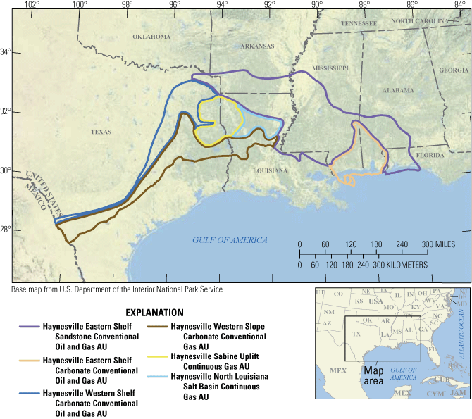
Map showing the location of four conventional and two continuous assessment units (AUs) in the Haynesville Formation.
The conventional AUs consist of sandstone or carbonate reservoirs in structural and stratigraphic traps sourced by Smackover, Haynesville, and possibly Bossier source rocks where faulting can cause juxtaposition that facilitates charge from younger formations. The Haynesville Eastern Shelf Sandstone Conventional Oil and Gas AU is defined as the part of the study area where sandstone reservoirs are common and is limited updip by erosion or nondeposition and downdip by facies changes to nonsandstone reservoirs, drilling limits, and the boundary between State and Federal waters. The Haynesville Eastern Shelf Carbonate Conventional Oil and Gas AU is defined as the area in southern Louisiana, Mississippi, and Alabama where carbonate reservoirs dominate and is limited downdip by technical drilling limits and the State waters boundary. The Haynesville Western Shelf Carbonate Conventional Oil and Gas AU is defined by the presence of shelf carbonate reservoirs in Texas and is bound updip by nondeposition or erosion and downdip by changes to other lithologies. The Haynesville Western Slope Carbonate Conventional Gas AU is defined as the area encompassing carbonate slope reservoirs in Texas and Louisiana and is bound updip by lithology changes and downdip by drilling limits. The key input data for the conventional Haynesville Formation AUs are shown in table 1 and Gardner (2025). The recent (as of 2025) shale gas development on the western side of the East Texas Basin, commonly called “Western Haynesville” by industry (Morenne, 2025), is not included in this assessment because detailed correlation of well logs and seismic data indicates that production in these wells is actually coming from Bossier Formation-equivalent strata.
Table 1.
Key input data for four conventional and two continuous oil and gas assessment units in the Haynesville Formation.[Gray shading indicates not applicable. The average estimated ultimate recovery (EUR) input is the minimum, median, maximum, and calculated mean. AU, assessment unit; MMBO, million barrels of oil; BCFG, billion cubic feet of gas; %, percent]
The continuous AUs are organic-rich mudrock reservoirs in eastern Texas and northern Louisiana that are self-sourcing but also have potential contributions from Smackover-sourced gas. The Haynesville Sabine Uplift Continuous Gas AU is the primary productive area of the horizontal Haynesville Formation play bound by lithology changes to the north, west, and south and is characterized by overpressure. This AU has been targeted primarily by horizontal drilling practices. Despite a similar depositional environment continuing to the east, the lack of production data creates large uncertainty and necessitates a separate AU. The Haynesville North Louisiana Salt Basin Continuous Gas AU is defined as the area of mudrock-dominated deposition in northern Louisiana, and there are only a few penetrations and no completed wells in the Haynesville Formation for this AU. The key input data for the continuous Haynesville Formation AUs are shown in table 1 and Gardner (2025).
Undiscovered Resources Summary
The USGS quantitatively assessed four conventional and two continuous AUs for undiscovered oil, gas, and natural gas liquid resources in the Haynesville Formation. The estimated mean total resources in all AUs are 152 million barrels of oil (MMBO), with an F95–F5 range from 11 to 612 MMBO; 47,882 billion cubic feet of gas (BCFG), or 47.9 trillion cubic feet of gas, with an F95–F5 range from 14,156 to 87,218 BCFG; and 170 million barrels of natural gas liquids (MMBNGL), with an F95–F5 range from 37 to 443 MMBNGL (table 2).
Table 2.
Results for four conventional and two continuous oil and gas assessment units in the Haynesville Formation.[Gray shading indicates not applicable. Results shown are fully risked estimates. F95 represents a 95-percent chance of at least the amount tabulated; other fractiles are defined similarly. MMBO, million barrels of oil; BCFG, billion cubic feet of gas; NGL, natural gas liquids; MMBNGL, million barrels of natural gas liquids]
For More Information
Assessment results are also available at the USGS Energy Resources Program website, https://www.usgs.gov/programs/energy-resources-program.
References Cited
Cicero, A.D., and Steinhoff, I., 2013, Sequence stratigraphy and depositional environments of the Haynesville and Bossier shales, east Texas and north Louisiana, chap. 3 of Hammes, U., and Gale, J., eds., Geology of the Haynesville gas shale in east Texas and west Louisiana, U.S.A.: AAPG Memoir 105, p. 25–46, accessed January 1, 2024, at https://doi.org/10.1306/13441843M1053598.
Gardner, R., 2025, USGS National and Global Oil and Gas Assessment Project—Gulf Coast Mesozoic Province, Haynesville Formation—Assessment unit boundaries, assessment input tables, and fact sheet data tables: U.S. Geological Survey data release, https://doi.org/10.5066/P1AQ879T.
Morenne, B., 2025, Jerry Jones says he has unlocked a $100 billion gas bounty in this drilling inferno: The Wall Street Journal, October 29, 2025, accessed November 20, 2025, at https://www.wsj.com/business/energy-oil/jerry-jones-comstock-resources-texas-f11636d6?reflink=desktopwebshare_permalink.
Paxton, S.T., Pitman, J.K., Kinney, S.A., Gianoutsos, N.J., Pearson, O.N., Whidden, K.J., Dubiel, R.F., Schenk, C.J., Burke, L.A., Klett, T.R., Leathers-Miller, H.M., Mercier, T.J., Haines, S.S., Varela, B.A., Le, P.A., Finn, T.M., Gaswirth, S.B., Hawkins, S.J., Marra, K.R., and Tennyson, M.E., 2017, Assessment of undiscovered oil and gas resources in the Haynesville Formation, U.S. Gulf Coast, 2016: U.S. Geological Survey Fact Sheet 2017–3016, 2 p., accessed July 1, 2024, at https://doi.org/10.3133/fs20173016.
S&P Global Commodity Insights, 2024, Enerdeq US well history and production database: Englewood, Colo., S&P Global Commodity Insights, accessed January 1, 2024, at https://spglobal.com/commodityinsights. [Available from S&P Global Commodity Insights, 15 Inverness Way East, Englewood, CO 80112.]
Whidden, K.J., Birdwell, J.E., Gardner, R.D., Kinney, S.A., Paxton, S.T., Pitman, J.K., and Schenk, C.J., 2023, Assessment of continuous oil and gas resources in the Upper Jurassic Smackover Formation of the onshore U.S. Gulf Coast, 2022: U.S. Geological Survey Fact Sheet 2023–3021, 4 p., accessed July 1, 2024, at https://doi.org/10.3133/fs20233021.
Disclaimers
Any use of trade, firm, or product names is for descriptive purposes only and does not imply endorsement by the U.S. Government.
Although this information product, for the most part, is in the public domain, it also may contain copyrighted materials as noted in the text. Permission to reproduce copyrighted items must be secured from the copyright owner.
Suggested Citation
Gardner, R., Flaum, J.A., Birdwell, J.E., Kinney, S.A., Pitman, J.K., Paxton, S.T., French, K.L., Mercier, T.J., Leathers-Miller, H.M., and Schenk, C.J., 2025, Assessment of undiscovered oil and gas resources in the Haynesville Formation within the onshore United States and State waters of the Gulf Coast Basin, 2024: U.S. Geological Survey Fact Sheet 2025–3054, 4 p., https://doi.org/10.3133/fs20253054.
ISSN: 2327-6932 (online)
Study Area
| Publication type | Report |
|---|---|
| Publication Subtype | USGS Numbered Series |
| Title | Assessment of undiscovered oil and gas resources in the Haynesville Formation within the onshore United States and State waters of the Gulf Coast Basin, 2024 |
| Series title | Fact Sheet |
| Series number | 2025-3054 |
| DOI | 10.3133/fs20253054 |
| Publication Date | December 17, 2025 |
| Year Published | 2025 |
| Language | English |
| Publisher | U.S. Geological Survey |
| Publisher location | Reston, VA |
| Contributing office(s) | Central Energy Resources Science Center |
| Description | Report: 4 p.; Data Release |
| Country | United States |
| State | Alabama, Arkansas, Florida, Louisiana, Mississippi, Texas |
| Other Geospatial | Gulf Coast basin |
| Online Only (Y/N) | Y |
| Additional Online Files (Y/N) | N |