

Recent Scientific Contributions by the U.S. Geological Survey in the San Francisco Bay and Sacramento–San Joaquin Delta Estuary
Links
- Document: Report (14.3 MB pdf) , HTML , XML
- NGMDB Index Page: National Geologic Map Database Index Page (html)
- Download citation as: RIS | Dublin Core
Plain Language Summary
The U.S. Geological Survey (USGS) is the primary science agency of the U.S. Department of the Interior. In the San Francisco Bay and Sacramento–San Joaquin Delta Estuary (Bay-Delta) of California, the USGS plays a unique role in providing scientific leadership because of its broad research and monitoring capabilities, innovative methodologies for data collection and analysis, and dedication to objective and credible science. This fact sheet provides a summary of recent USGS projects across the Bay-Delta organized under five major research themes: water flow and water quality, fish and wildlife, wetland restoration, invasive species, and hazards. A key component of USGS research is close collaboration with State and Federal partners, academia, and non-governmental organizations to accomplish its goals. The research and partnerships described in this fact sheet are critical to the management of the complex natural resource issues across the Bay-Delta region of California.
Introduction
The San Francisco Bay and the Sacramento–San Joaquin Delta Estuary (hereafter, Bay-Delta) is the largest estuary on the West Coast of the United States. The Bay-Delta covers more than 1,600 square miles and drains a watershed of more than 75,000 square miles, which is greater than 40 percent of California. The region surrounding the Bay-Delta is home to about 10 million people, and its habitats (fig. 1) support more than 800 plant and animal species. The waterways of the Bay-Delta are the central hub of California’s extensive freshwater delivery system, supplying water to more than 27 million Californians and 4 million acres of farmland in the Central Valley.
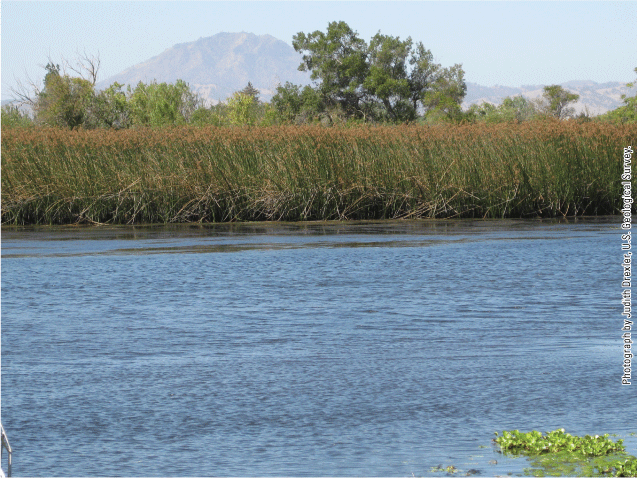
A tidal freshwater marsh, a habitat type in the Sacramento–San Joaquin Delta of California, dominated by tule vegetation (here, Schoenoplectus acutus) and situated along a channel with Mount Diablo as the backdrop. Photograph by Judith Z. Drexler, U.S. Geological Survey.
The U.S. Geological Survey (USGS) is the primary science agency of the U.S. Department of the Interior, providing a broad range of Earth, water, biological, and mapping data and expertise to inform natural resource management across the country. This fact sheet focuses on research conducted by the USGS in the Bay-Delta region, mostly within the past 5 years. The fact sheet is organized across five major themes: water flow and water quality, fish and wildlife, wetland restoration, invasive species, and hazards. In each of these areas, the USGS works closely with Federal, State, and local agencies; academia; and non-governmental organizations to provide objective, evidence-based science. The data and knowledge gained from USGS research and monitoring are publicly available and are routinely used by agencies, including the U.S. Bureau of Reclamation, U.S. Army Corps of Engineers, U.S. Fish and Wildlife Service, California Department of Water Resources, California Department of Fish and Wildlife, California State Water Resources Control Board, Delta Stewardship Council, and many additional organizations and stakeholders to inform management of the Bay-Delta region and its resources.
U.S. Geological Survey Role
USGS scientists collaborate closely with a wide range of partners to identify, conduct, and communicate the science needed to address the complex natural resource issues in the Bay-Delta region. The USGS provides leadership across multiple scientific disciplines by participating in expert panels, advisory committees, and work teams dedicated to protecting California’s resources, environment, and infrastructure. In close collaboration with the Delta Stewardship Council, the USGS provides support for the lead scientist, who oversees the Delta Science Program and consults with partner agencies to inform water and environmental management decisions for the Delta region. The lead scientist also oversees the Delta Science Plan, which is a complex organizational framework updated every 5 years that coordinates science in the Delta and communicates results and management implications of scientific studies to policymakers. The USGS also supports the biennial Bay-Delta Science Conference and other regional conferences and workshops.
The USGS plays a unique scientific role in the Bay-Delta region because of its extensive and innovative research and monitoring capacity, long-standing and diverse partnerships, and established procedures for ensuring objective and credible science. Of particular relevance in the Bay-Delta are the contributions by the USGS in cutting-edge technologies for data collection and analysis as well as long-term monitoring, which provide the data needed to understand changes in the landscape and waters of the Bay-Delta.
Water Flow and Water Quality
The USGS conducts long-term monitoring and special studies in the Bay-Delta to inform Federal and State agencies responsible for managing water resources, maintaining ecosystem health, and protecting multiple beneficial uses. These activities have relied strongly on support from the California Department of Water Resources and historically from the U.S. Bureau of Reclamation. Essential to these efforts is a large network of real-time, continuous monitoring stations equipped with a suite of instruments measuring physical, chemical, and biological parameters (fig. 2). Core parameters include stage, flow, temperature, salinity, turbidity, pH, dissolved oxygen, chlorophyll, phytoplankton species composition, dissolved organic matter, nitrate, near-field radiometry, and fish movement. These stations are visited regularly to ensure instruments are operating correctly and to collect discrete samples for a suite of additional analyses. Data from these stations are critical to meet flow and salinity regulations that protect endangered fish, drinking water quality, and water supply. These data are used by numerous agencies, including the U.S. Bureau of Reclamation, U.S. Army Corps of Engineers, and the California Department of Water Resources, in real-time and predictive models.
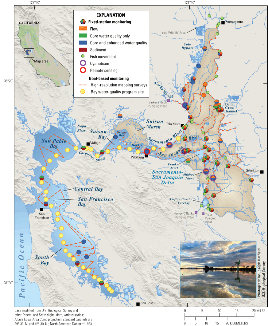
The network of current and recent U.S. Geological Survey (USGS) continuous and regularly sampled monitoring stations and sites in the San Francisco Bay and the Sacramento–San Joaquin Delta region. Flow and water quality monitoring stations collect continuous core hydrologic and water-quality data every 15 minutes. At some locations, enhanced water-quality stations collect additional data on phytoplankton, nutrients, dissolved organic carbon, sediment, and cyanotoxins. Acoustic receivers record information about fish movement through the region. A remote sensing reference station near Pittsburg collects data that help develop and validate sensors and algorithms. Sampling by boat bi-weekly or monthly has been used to monitor water-quality at sites from the Lower South Bay to Rio Vista since 1969. High-resolution mapping surveys are also conducted using boats equipped with flow-through sensor systems to collect data every second as the boats travel along a transect. Inset photograph: sunset at water quality and water flow monitoring station 11455385 in Rio Vista, California. All station information and data for this and any other station are available at the USGS National Water Dashboard.
The USGS has developed new technologies for continuous, high-resolution measurements of water-quality parameters and has implemented new monitoring approaches to assess habitat quality, ecological productivity, and biogeochemical processes across the Bay-Delta region. Further, the USGS uses data from this network to compare how water quality and nutrient parameters change across seasons and water years. These high frequency, real-time data can be used to pinpoint rapidly changing or unexpected conditions that result from harmful algal blooms (HABs; see “Harmful Algal Blooms” inset), drought, storms, and levee breaches.
The USGS also conducts water-quality studies beyond the monitoring network. For example, USGS scientists study the levels and environmental effects of an ever-changing array of pesticides that are used in urban and agricultural areas of the Delta. State agencies, including the Central Valley Regional Water Quality Control Board and the California Department of Pesticide Regulation, use these data to monitor overall pesticide fate and transport and, for specific pesticides, determine 303(d) listings of waters not meeting water-quality standards under the Clean Water Act and total maximum daily loads. In another study, the USGS is using satellite imagery, shipboard radiometry, and water sampling to create maps of multiple forms of mercury in the south San Francisco Bay (South Bay), including methyl mercury, which is toxic to humans and wildlife. Such maps are being used by the California State Water Quality Control Board and the U.S. Environmental Protection Agency to improve mercury monitoring, especially after major storms.
Harmful Algal Blooms
Harmful algal blooms (figs. 3, 4) occur in freshwater and marine habitats of the Bay-Delta. HABs can form as a result of one or more of the following: high nutrient concentrations in wastewater discharge, drought conditions, and water-management practices. Toxins produced by HABs can sicken or even kill fish, marine mammals, and birds. Humans who are exposed to HABs can experience a range of symptoms from minor skin irritations to pneumonia or neurological problems. HABs also can reduce drinking water quality and impede the use of waterways and aquatic resources.
The USGS investigates the dynamic formation of HABs by monitoring phytoplankton abundance and species composition, cyanotoxin concentrations, genetic composition of specific blooms, and related water-quality parameters throughout the Bay-Delta, including at enhanced USGS water-quality stations and during USGS mapping surveys (fig. 2). State and Regional Water Boards, the California Department of Water Resources, and many other agencies and non-governmental organizations rely on these data to monitor and respond to HAB events as well as develop an understanding of factors that lead to their occurrence. USGS scientists are working with the California Department of Water Resources and the San Francisco Estuary Institute to develop a new Bay-Delta strategy for HAB monitoring. The USGS also is working to improve future monitoring efforts by melding remote sensing approaches with field data to reduce the cost and expand the geographical footprint of data collection. A future goal is to use high-quality data to develop predictive models for forecasting HABs throughout the Bay-Delta region.
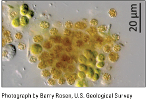
A microscopic view of Microcystis, a common cyanobacteria, or blue-green algae, that can form harmful algal blooms. Certain strains of Microcystis release liver toxins that can harm fish, marine mammals, and humans. Abbreviation: µm, micron.
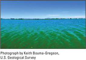
A wide-angle view of a harmful algal bloom dominated by the cyanobacterial genus Dolichospermum, which turned the water green at Franks Tract State Recreation Area in the Sacramento–San Joaquin Delta of California on August 3, 2022.
Fish and Wildlife
The USGS conducts research and monitoring on fish and wildlife, food webs, and habitats in the Bay-Delta. Fish research is focused largely on life history studies, habitat use, and modeling of resource management and environmental effects on imperiled populations, including delta smelt (Hypomesus transpacificus), Chinook salmon (Oncorhynchus tshawytscha), longfin smelt (Spirinchus thaleichthys; fig. 5), and Central Valley steelhead (Oncorhynchus mykiss). Examples of recent work in the Bay-Delta include the study of a bioacoustic fish fence to protect juvenile Chinook salmon and steelhead migrating through the Bay-Delta, the tracking of green sturgeon populations during construction of flood control structures, and the development of a hydrodynamic and sediment model to assess fish habitat quality. The USGS also has been studying the effect of wetland restoration on native fish using a novel physics to fish approach, predicated on the idea that high-quality habitat relies on interactions among physical, chemical, and biological processes and the landscape at various spatial and temporal scales. This research has provided USGS partners such as the California Department of Water Resources, the U.S. Bureau of Reclamation, and the California Department of Fish and Wildlife with approaches to improve fish habitat that require little to no additional water flows.
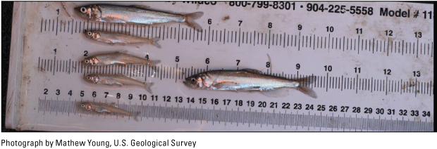
The U.S. Geological Survey collects multiple age classes of longfin smelt (Spirinchus thaleichthys) from Suisun Bay, California, to increase knowledge about life history and provide inputs for future population modeling. This information is used by the U.S. Army Corps of Engineers to guide monitoring and dredging operations and by the California Department of Fish and Wildlife and U.S. Fish and Wildlife Service to support conservation and management.
Wildlife studies conducted by the USGS in the Bay-Delta are focused on avian health, habitat, and population dynamics. An important recent advance is the Automated Interactive Monitoring System for Wildlife (AIMS), which uses Global Positioning System (GPS) tracking of 25 bird species in real time (fig. 6). This product was applied successfully to the development of a data-driven model to predict the future spread of highly pathogenic avian influenza virus in wild waterfowl in the Bay-Delta region. Another area of study related to avian health is mercury contamination. The USGS has determined methylmercury toxicity reference values for a broad range of bird species that are found in the Central Valley and Bay-Delta, as well as shown a linkage between prior infection with avian influenza and increased mercury toxicity in wild ducks. The USGS also is studying changes to waterbird habitat from wetland restoration. A study based in the south San Francisco Bay has shown a decline in nest abundance of American avocets (Recurvirostra americana), black-necked stilts (Himantopus mexicanus), and Forster’s terns (Sterna forsteri) between 2005 and 2019, which is likely due to tidal marsh conversion and subsequent increased predation. These and other wildlife studies are helping the U.S. Fish and Wildlife Service, California Department of Fish and Wildlife, and other agencies and organizations improve habitat and monitor avian diseases on their lands.
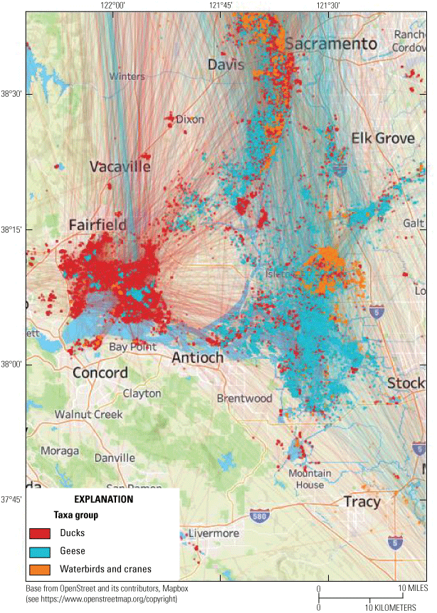
A map from the Automated Interactive Monitoring System for Wildlife (AIMS) showing the Global Positioning System (GPS)-marked waterbird tracks in the Sacramento–San Joaquin Delta from January 20, 2015, through February 10, 2025. The data contain more than 75,000 hourly locations from 1,042 individuals and 25 species. Many dabbling ducks (red) were captured in Suisun Marsh. Sandhill cranes and other waterbirds (orange) were captured within the Sacramento–San Joaquin Delta (Staten Island) and Yolo Wildlife Area. Almost all geese (blue) were captured outside the San Francisco Bay and Sacramento–San Joaquin Delta region. Such data show how the flyway in California is connected to other geographical areas including the Great Basin and Great Salt Lake.
Wetland Restoration
Since the California Gold Rush, 85 percent of wetlands in the San Francisco Bay and 98 percent of Delta wetlands were converted to other land uses, reducing the ecosystem services, such as flood control and habitat provided by these wetlands. Several efforts, including the South Bay Salt Ponds Project, California EcoRestore, the California Water Bond (Proposition 1), and the San Francisco Bay Clean Water, Pollution Prevention, and Habitat Restoration Measure (Measure AA), have sought to mitigate these losses by restoring wetlands in the Bay-Delta. Projects supported by these initiatives are providing flood protection, improving sensitive wildlife populations, mitigating land-surface subsidence, and increasing carbon storage on the landscape.
The USGS carries out a wide range of research and monitoring to improve the science and methodologies used in wetland restoration projects throughout the Bay-Delta. USGS projects have determined rates of wetland elevation gain (fig. 7), the role of sediment management in building wetlands during the restoration process, how vegetation develops in restored wetlands, and whether or not restored wetlands support threatened and endangered species. In one recent study, the USGS, U.S. Army Corps of Engineers, and the Port of Redwood City are working together to test the efficacy of strategically placing dredged material in areas where natural wave energy and currents can redistribute sediment to wetlands, increasing their long-term resilience. In a project led by the California Department of Water Resources, the USGS is studying how carbon dynamics are changing after restoration in the 1,200-acre Dutch Slough Tidal Wetland in the southwest Delta (fig. 8). The Dutch Slough project adds to the rich dataset of carbon dynamics and evapotranspiration being collected by the USGS at Rush Ranch in Suisun Marsh since 2014.
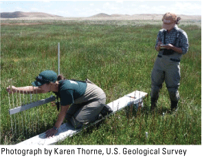
U.S. Geological Survey (USGS) researchers use a sedimentation erosion table (SET) to measure small changes in marsh surface elevation, which provides information on the ability of the marsh to maintain its elevation relative to the tidal frame, February 2025, Rush Ranch, Suisun City, California.
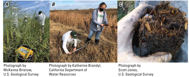
The Dutch Slough Tidal Wetland Restoration, led by the California Department of Water Resources, is being used as a living laboratory to study wetland restoration processes. U.S. Geological Survey researchers have measured carbon dynamics over vegetation, soil, and open water using A, a laser gas analyzer and B, extracted cores to study C, carbon storage in the soils. The carbon dynamics in pasture, impounded marsh, and restored and historical tidal marsh are being studied to determine how seasonality, restoration design choices, and the process of wetland restoration affect carbon storage.
Invasive Species
The USGS has been involved in numerous projects on the effects of invasive flora and fauna in the Bay-Delta. For example, the USGS has determined that salinity largely controls populations of invasive Amur River clams (Potamocorbula amurensis) and Asian clams (Corbicula fluminea), which dramatically reduce phytoplankton biomass at the base of the food web. This research indicated that invasive clam populations could potentially be controlled by manipulating the flow regime in Delta waterways. The data and results from these projects help managers at California agencies, including the Department of Water Resources, Department of Fish and Wildlife, and the Division of Boating and Waterways, to choose the most effective management and control options.
The USGS also has been involved in studying how the long-term presence of invaders can lead to the degradation of ecosystem properties and processes in the Bay-Delta. For example, the USGS recently conducted a multi-disciplinary project on how long-term (more than 70 years), Delta-wide infestation by the submersed aquatic plant Brazilian waterweed (Egeria densa) is blocking suspended sediment in the water column from reaching adjacent tidal wetlands, reducing their long-term resilience (fig. 9). Another project on water primrose (Ludwigia hexapetala), a floating aquatic plant, determined that water primrose exudes a toxic tea through its leaves, likely helping it to outcompete native plants and take over large areas of native tule marsh. USGS projects such as these provide key information on how invasive species are altering the quality and functions of ecosystems. Such information can assist managers at the California Division of Boating and Waterways and other agencies to prioritize species and specific locations in the Bay-Delta for management and control.
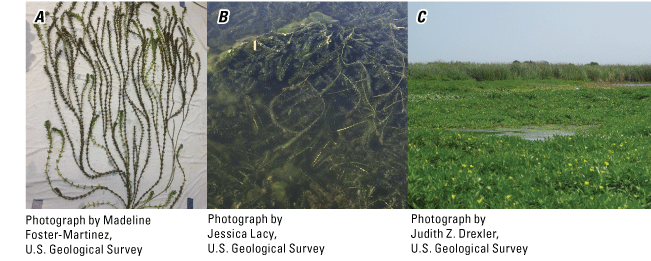
Invasive aquatic vegetation in the Delta includes Brazilian waterweed (Egeria densa) whose A, densely branched architecture in B, channel environments is blocking sediment needed by adjacent marshes to maintain their intertidal elevation and C, water primrose (Ludwigia hexapetala), a species that is increasingly overtaking native marshes in the Delta.
Hazards
The USGS provides actionable science to understand and determine risks to people, infrastructure, and the environment from hazards, including weather extremes, flooding and increasing coastal inundation, landslides, wildfire, and earthquakes. In California, weather whiplash is increasingly common, wherein conditions alternate between multiple years of extreme drought and intermittent years of severe flooding. The USGS has developed the Coastal Storm Modeling System (CoSMoS), which predicts coastal flooding, erosion, and rising groundwater levels using sea-level and storm projections together with data on long-term coastal evolution over large regions. CoSMoS provides local flood hazard maps for a range of scenarios, which can be used by emergency managers and coastal planners to protect public safety, avoid damage to infrastructure, and manage coastal resources. CoSMoS products are delivered via two web tools that can assist communities, agencies, and organizations in developing coastal resilience and adaptation plans: (1) the USGS Hazard Exposure Reporting and Analytics tool and (2) the multi-collaborator Our Coast Our Future tool.
USGS research in the Bay-Delta also is improving the understanding of how weather extremes and changing weather patterns may affect the future sustainability of water supplies, ecosystems, working lands, and populations of sensitive species. For example, in collaboration with the San Francisco Estuary Institute and the University of South Carolina, the USGS developed the Coastal Wetland Equilibrium Model, which projects the long-term sustainability of Delta marshes and provides key metrics of marsh degradation under future sea-level scenarios. The USGS also contributed to a synthesis report by the California Interagency Ecological Program, a consortium of nine State and Federal agencies, on the potential effects of future weather extremes on marshes, floodplains, and open-water areas and their biota in the Delta and Suisun Bay. In another study covering the same geographic area, the USGS and partners assessed the potential of three different approaches for increasing carbon storage: (1) restoration of impounded, managed wetlands; (2) targeted agricultural water management; and (3) reintroduction of tides to intertidal and sub-tidal habitats. Each of these studies has provided valuable information to partners, such as the Delta Stewardship Council, California Department of Water Resources, and the California Department of Fish and Wildlife so they can better manage resources, ecosystems, and sensitive species of the Bay-Delta region into the future.
The San Francisco Bay Area is highly susceptible to landslides due to its steep topography and the high amount and intensity of rainfall during the winter season. The USGS is addressing landslide hazards by monitoring, providing alerts, and increasing public awareness and preparedness (fig. 10). As part of this effort, the USGS is working with the National Weather Service in the San Francisco Bay Area on hillslope soil moisture monitoring to predict conditions conducive to debris flows, which are dangerous, fast-moving landslides that can carry large items, such as boulders, trees, and cars. In addition, new Light Detection and Ranging (LiDAR) imaging of the entire Bay-Delta was captured in summer 2025 as part of the USGS 3D Elevation Program. Digital terrain models derived from LiDAR will allow for improved assessments and planning related to landslides, flooding, faults, and tsunamis.
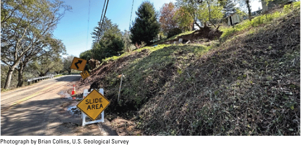
A landslide along Wildcat Canyon Road in the hills of Berkeley, California, that resulted from a series of major storms classified as atmospheric rivers (long, narrow corridors of concentrated moisture in the atmosphere) in January 2023.
Wildfire is an increasingly important hazard across the western United States, particularly where human development and wildland vegetation meet. In the Bay-Delta, the USGS is mainly involved in studies related to the aftereffects of wildfire, such as vegetation recovery, the increased risk of landslides, the transport of contaminants to streams, and reduced water quality for communities. For example, a recent USGS study demonstrated quick recovery of wetland vegetation after a wildfire with no changes in plant community composition.
The USGS continuously monitors for earthquakes in the Bay-Delta via the Northern California Seismic Network. In the San Francisco Bay Area, a recent project named the “HayWired Scenario” examined the potential impacts on infrastructure, communities, and economies of a 7.0 earthquake along the Hayward fault. The scenario was developed to inform the public and key partners, including the Earthquake Country Alliance and the California Resiliency Alliance, about ways to reduce risks and increase resilience to major earthquakes. In the Delta, earthquakes are less common and faults are less visible; however, earthquakes are of particular concern because they could rupture levees that protect farmlands, affecting farming operations and the integrity of the California water delivery system. A recent USGS study mapped the active faults in the Delta and western Central Valley region and determined how they are moving, which will help improve knowledge about potential earthquake risks in the area.
Conclusions
The U.S. Geological Survey (USGS), in collaboration with a broad network of partners in Federal, State, and local agencies; academic institutions; and non-governmental organizations, continues to provide reliable, valuable, and impartial science to address environmental, resource, and public safety issues throughout the San Francisco Bay and Sacramento–San Joaquin Delta region. The research projects described here are examples of how the USGS carries out its mission of monitoring, analyzing, and predicting the complex and interconnected processes of the Earth to provide actionable information to managers and policymakers whose decisions affect people and the environment at local to international scales. More details on San Francisco Bay and Sacramento–San Joaquin Delta research can be found at U.S. Geological Survey (2025) and the many links provided therein.
Reference Cited
U.S. Geological Survey, 2025, San Francisco Bay and Sacramento–San Joaquin Delta Estuary: U.S. Geological Survey website, accessed August 4, 2025, at https://www.usgs.gov/san-francisco-bay-and-sacramento-san-joaquin-delta-estuary.
For more information concerning the research in this report, contact the
Director, California Water Science Center
U.S. Geological Survey
6000 J Street, Placer Hall
Sacramento, California 95819
916-278-3000
https://www.usgs.gov/centers/california-water-science-center
Publishing support provided by the USGS Science Publishing Network,
Sacramento Publishing Service Center
Disclaimers
Any use of trade, firm, or product names is for descriptive purposes only and does not imply endorsement by the U.S. Government.
Although this information product, for the most part, is in the public domain, it also may contain copyrighted materials as noted in the text. Permission to reproduce copyrighted items must be secured from the copyright owner.
Suggested Citation
Drexler, J.Z., and Weltzin, J.F., 2026, Recent scientific contributions by the U.S. Geological Survey in the San Francisco Bay and Sacramento–San Joaquin Delta Estuary: U.S. Geological Survey Fact Sheet 2025–3058, 6 p., https://doi.org/10.3133/fs20253058.
ISSN: 2327-6932 (online)
Study Area
| Publication type | Report |
|---|---|
| Publication Subtype | USGS Numbered Series |
| Title | Recent scientific contributions by the U.S. Geological Survey in the San Francisco Bay and Sacramento–San Joaquin Delta Estuary |
| Series title | Fact Sheet |
| Series number | 2025-3058 |
| DOI | 10.3133/fs20253058 |
| Publication Date | January 26, 2026 |
| Year Published | 2026 |
| Language | English |
| Publisher | U.S. Geological Survey |
| Publisher location | Reston, VA |
| Contributing office(s) | California Water Science Center |
| Description | 6 p. |
| Country | United States |
| State | California |
| Other Geospatial | Sacramento–San Joaquin Delta Estuary, San Francisco Bay |
| Online Only (Y/N) | Y |