

Landsat 8–9 Geometric and Radiometric Calibration and Characterization
Links
- Document: Report (8.7 MB pdf) , HTML , XML
- Download citation as: RIS | Dublin Core
Abstract
The U.S. Geological Survey (USGS) Earth Resources Observation and Science Cal/Val (Calibration and Validation) Center of Excellence (ECCOE) is a global leader in improving the accuracy, precision, and quality of remote-sensing data. Calibration is the process of quantitatively defining a system’s response to known and controlled signal inputs. Validation is the process of assessing, by independent means, the quality of the calibrated data products derived from system outputs (Committee on Earth Observation Satellites, 2025).
The Landsat Cal/Val team, comanaged by ECCOE and the National Aeronautics and Space Administration (NASA) Landsat Science Project, continually monitors the geometric and radiometric performance of active Landsat missions and makes calibration adjustments, as needed, to maintain data quality at the highest level (Haque and others, 2024), ensuring its reliability for scientific research (Hemati and others, 2021). Landsat data quality is often referred to as the “gold standard” (National Geospatial Advisory Committee, 2020; NASA, 2025) and gives other civil and commercial satellite programs a trusted reference point for measuring their own data quality (Wulder and others, 2019).
The Landsat program started more than 50 years ago. Since then, Landsat missions have gone through multiple technological advances, which, together with improved calibration and validation techniques, have led to higher data quality over time (Mishra and others, 2016). The Cal/Val team also maintains consistency in data calibration across the multiple generations of sensors, which is vital to many scientists for time-series analysis (Bullock and others, 2020; Zhu and others, 2020).
Overview of Landsat 8–9 Sensors
Landsats 8 and 9 carry two sensors: the Operational Land Imager (OLI) and the Thermal Infrared Sensor (TIRS). Both sensors image the Earth with a 185-kilometer swath in the east-west across-track direction. An example of a Landsat 9 OLI Level 0 three-band color composite shows the staggered sensor chip assembly (SCA), detector, and band misalignment between OLI spectral bands (fig. 1). The OLI focal plane is made up of 14 SCAs with 9 spectral bands that cover the visible, near-infrared, and shortwave infrared reflective regions of the electromagnetic spectrum (fig. 2). All OLI bands have a 30-meter spatial resolution, with the exception of a 15-meter panchromatic band.
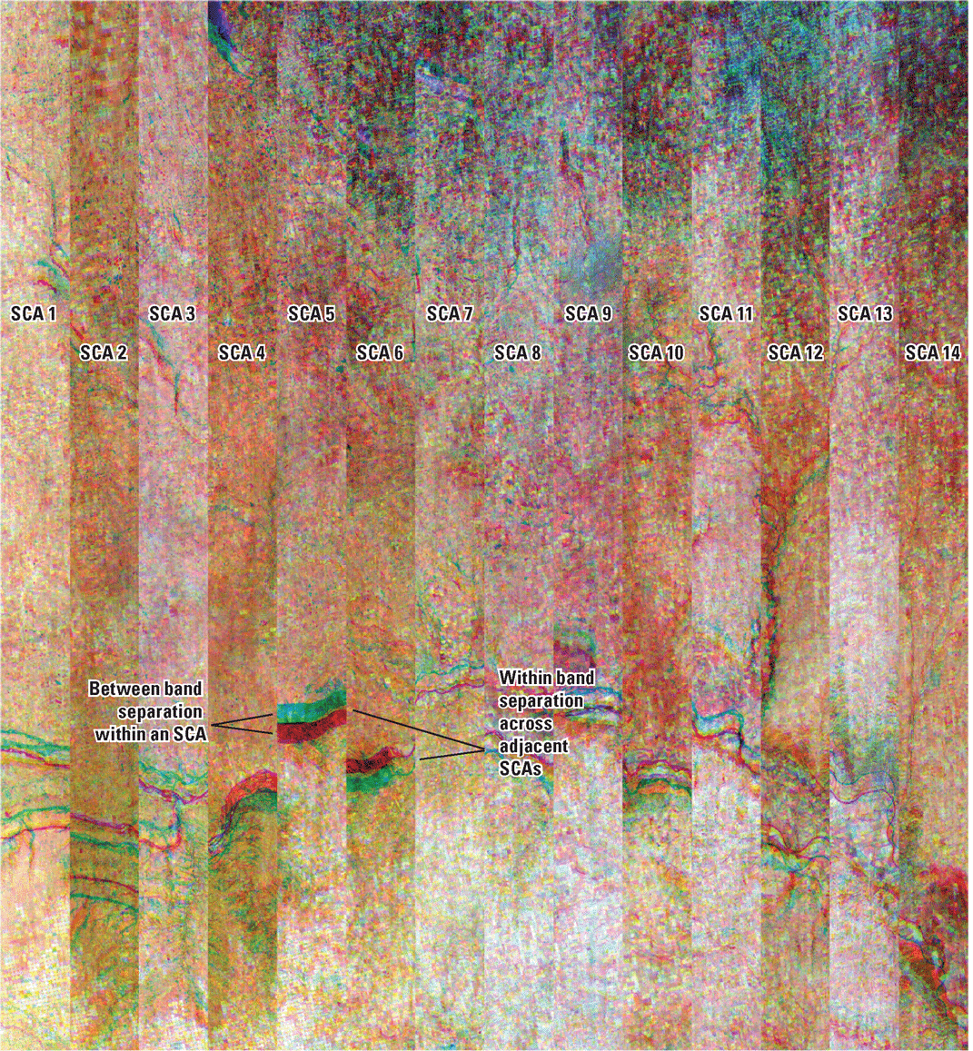
Landsat 9 Operational Land Imager shortwave infrared 1, near-infrared, and red bands (bands 6, 5, and 4) in Level 0 image (from Shaw and others [2024]). [SCA, sensor chip assembly]
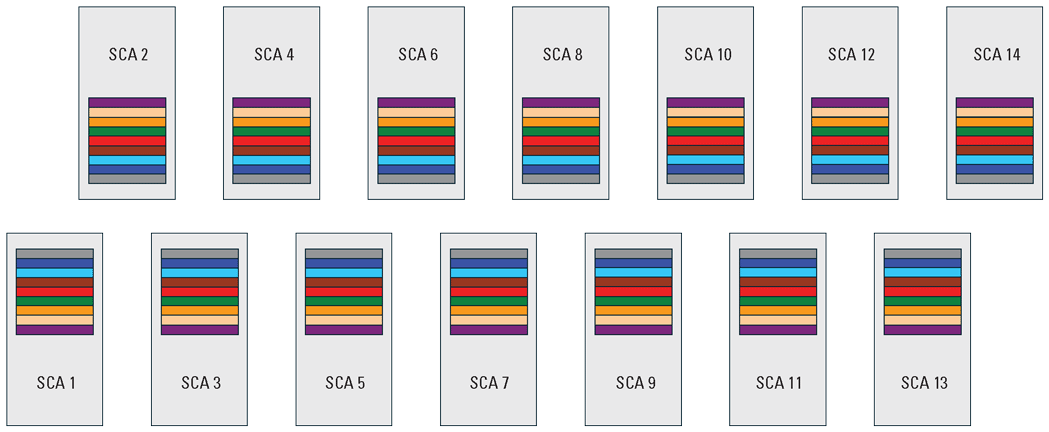
Operational Land Imager focal plane. [SCA, sensor chip assembly]
The TIRS focal plane is made up of 3 staggered SCAs (A, B, and C) with 2 spectral bands in the thermal emissive region of the electromagnetic spectrum (fig. 3). Both bands have a spatial resolution of 100 meters.
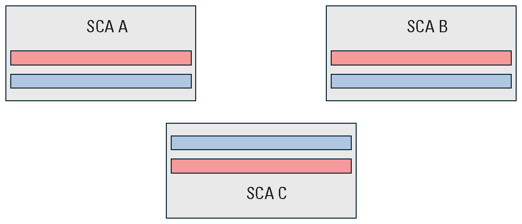
Thermal Infrared Sensor focal plane. [SCA, sensor chip assembly]
Geometric and Radiometric Characterization and Calibration
Many factors affect the pixels in a final Landsat image product. Sensor artifacts, viewing and illumination angles, atmospheric conditions, terrain, stray light, spectral variation, and spacecraft attitude (that is, its orientation in space) all affect the accuracy and quality of the data. To ensure that Landsat data meet the highest standards, the Landsat Cal/Val team regularly monitors and characterizes the performance of each sensor, the spacecraft, and the overall image. Calibration and validation processes work together to correct and verify performance, ensuring accurate and reliable images that deliver the best “gold standard” product to end users (National Geospatial Advisory Committee, 2020).
Geometric characterization assesses how sensor and spacecraft performance affect the placement of pixels within an image. Geometric calibration corrects these effects so that pixels appear in the correct geographic locations. Geometric validation independently assesses and reports the accuracy of pixel locations in the final product.
Radiometric characterization assesses sensor performance and its effects on pixel brightness within an image. Radiometric calibration removes sensor effects from image pixels and ties the image pixel values to an accepted reference to ensure the brightness values are scientifically correct. Radiometric validation independently assesses and reports the accuracy of those values in the final product.
Landsat 8–9 Data Correction
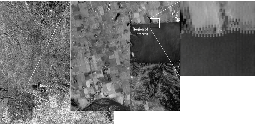
Raw Landsat data (Level 0) consist of uncorrected digital numbers captured by the sensors with geometric misalignment between odd and even detectors, SCAs, and spectral bands. An example of a Landsat 9 OLI Level 0 single-band image is shown in figure 4. Throughout the image, misalignment in the SCAs is visible. Discontinuities between two adjacent SCAs are shown in the inset image. The zoomed-in image shows odd and even detector staggering.
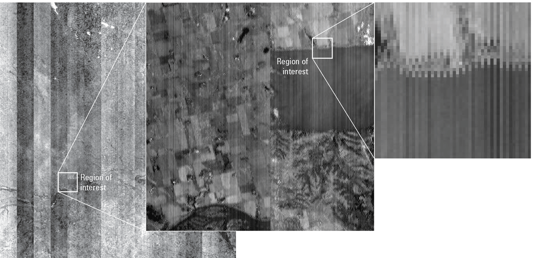
Landsat 9 Operational Land Imager red band Level 0 (from left to right) full image, inset image, and zoomed-in image.
Radiometrically corrected and geometrically raw Landsat data (Level 1R) contain the same geometric offsets present in Level 0 data, but the raw sensor values have been corrected and are represented as calibrated and scaled digital numbers. An example of a single-band grayscale Level 1R Landsat 9 OLI image is shown in figure 5. Within the image, geometric detector and SCA offsets are still visible, but radiometric distortions are corrected.
Landsat 9 Operational Land Imager red band (band 4) Level 1R (from left to right) full image, inset image, and zoomed-in image.
Radiometrically and geometrically corrected Landsat (Level 1) data consist of the radiometric correction applied in the Level 1R processing plus geometric correction. For Level 1 Terrain Precision (L1TP) products, the leading and trailing SCA imagery is removed, and data are geolocated and transformed to a map projection coordinate grid. Products are geometrically corrected and registered to the Landsat ground control library, which also accounts for terrain effects. The completion of these steps produces precise radiometric and geometric products that are well registered to each other. A single-band grayscale L1TP Landsat 9 OLI image is shown in figure 6. An L1TP three-band OLI color composite is shown in figure 7.
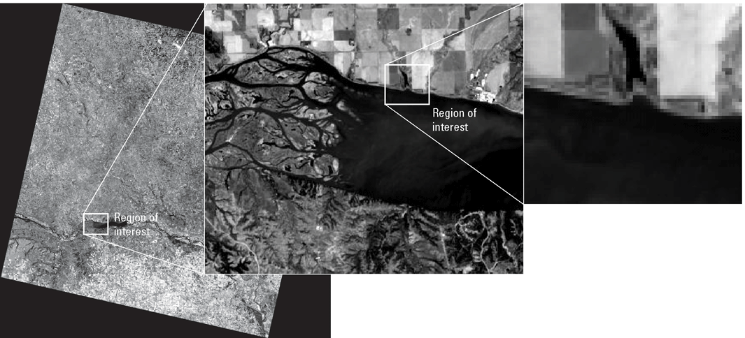
Landsat 9 Operational Land Imager red band (band 4) Level 1 Terrain Precision (from left to right) full image, inset image, and zoomed-in image.
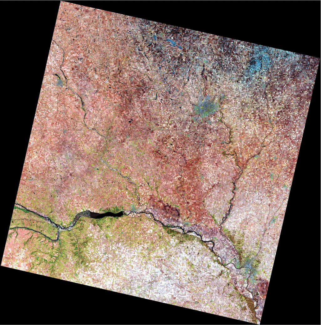
Landsat 9 Operational Land Imager Level 1 Terrain Precision true-color image consisting of shortwave infrared 1, near-infrared, and red bands (bands 6, 5, and 4).
The Landsat Cal/Val team continually monitors the geometric and radiometric performance of active Landsat missions and makes calibration adjustments as needed to maintain data quality at the highest level. Results of these analyses are summarized in quarterly USGS Open-File Reports (for example, U.S. Geological Survey [2025]).
References Cited
Bullock, E.L., Woodcock, C.E., and Olofsson, P., 2020, Monitoring tropical forest degradation using spectral unmixing and Landsat time series analysis: Remote Sensing of Environment, v. 238, article 110968, accessed July 2025 at https://www.sciencedirect.com/science/article/abs/pii/S0034425718305200.
Committee on Earth Observation Satellites, 2025, WGCV: Committee on Earth Observation Satellites website, accessed July 2025 at https://ceos.org/ourwork/workinggroups/wgcv/.
Haque, M.O., Hasan, M.N., Shrestha, A., Rengarajan, R., Lubke, M., Shaw, J.L., Ruslander, K., Micijevic, E., Choate, M.J., Anderson, C., Clauson, J., Thome, K., Barsi, J., Kaita, E., Levy, R., Miller, J., and Ding, L., 2024, ECCOE Landsat quarterly Calibration and Validation report—Quarter 1, 2024 (ver. 1.1, December 2024): U.S. Geological Survey Open-File Report 2024–1058, 57 p., accessed July 2025 at https://doi.org/10.3133/ofr20241058.
Hemati, M.A., Hasanlou, M., Mahdianpari, M., and Mohammadimanesh, F., 2021, A systematic review of Landsat data for change detection applications—50 years of monitoring the Earth: Remote Sensing, v. 13, no. 15, article 2869, accessed July 2025 at https://www.mdpi.com/2072-4292/13/15/2869.
Mishra, N., Helder, D., Barsi, J., and Markham, B., 2016, Continuous calibration improvements in solar reflective bands—Landsat 5 through Landsat 8: Remote Sensing of Environment, v. 185, 9 p., accessed July 2025 at https://www.sciencedirect.com/science/article/abs/pii/S0034425716302899.
National Aeronautics and Space Administration [NASA], 2025, Landsat 9 overview: National Aeronautics and Space Administration website, accessed July 2025 at https://landsat.gsfc.nasa.gov/satellites/landsat-9/landsat-9-overview.
National Geospatial Advisory Committee, 2020, Landsat data—Community standard for data calibration: Federal Geographic Data Committee, 12 p., accessed July 2025 at https://www.fgdc.gov/ngac/meetings/october-2020/ngac-paper-landsat-data-community-standard-for.pdf.
Shaw, J., Anderson, C., Choate, M., and Micijevic, E., 2024, Landsat geometric and radiometric calibration and characterization: U.S. Geological Survey Fact Sheet 2024–3039, 4 p., accessed July 2025 at https://doi.org/10.3133/fs20243039.
U.S. Geological Survey, 2025, EROS CalVal Center of Excellence (ECCOE)—Landsat Calibration and Validation: U.S. Geological Survey website, accessed July 2025 at https://www.usgs.gov/calval/landsat-calibration-and-validation.
Wulder, M.A., Loveland, T.R., Roy, D.P., Crawford, C.J., Masek, J.G., Woodcock, C.E., Allen, R.G., Anderson, M.C., Belward, A.S., Cohen, W.B., Dwyer, J., Erb, A., Gao, F., Griffiths, P., Helder, D., Hermosilla, T., Hipple, J.D., Hostert, P., Hughes, M.J., Huntington, J., Johnson, D.M., Kennedy, R., Kilic, A., Li, Z., Lymburner, L., McCorkel, J., Pahlevan, N., Scambos, T.A., Schaaf, C., Schott, J.R., Sheng, Y., Storey, J., Vermote, E., Vogelmann, J., White, J.C., Wynne, R.H., and Zhu, Z., 2019, Current status of Landsat program, science, and applications: Remote Sensing of Environment, v. 225, 41 p., accessed July 2025 at https://www.sciencedirect.com/science/article/pii/S0034425719300707.
Zhu, Z., Zhang, J., Yang, Z., Aljaddani, A.H., Cohen, W.B., Qiu, S., and Zhou, C., 2020, Continuous monitoring of land disturbance based on Landsat time series: Remote Sensing of Environment, v. 238, accessed July 2025 at https://www.sciencedirect.com/science/article/abs/pii/S0034425719301002.
For more information, contact:
U.S. Geological Survey, Earth Resources Observation and Science (EROS) Cal/Val Center of Excellence (ECCOE) project team
47914 252nd Street
Sioux Falls, SD 57198
Email: eccoe@usgs.gov
Publishing support provided by the
U.S. Geological Survey Science Publishing Network,
Rolla and Baltimore Publishing Service Centers
Disclaimers
Any use of trade, firm, or product names is for descriptive purposes only and does not imply endorsement by the U.S. Government.
Although this information product, for the most part, is in the public domain, it also may contain copyrighted materials as noted in the text. Permission to reproduce copyrighted items must be secured from the copyright owner.
Suggested Citation
Anderson, C., Choate, M.J., Micijevic, E., and Shaw, J.L., 2026, Landsat 8–9 geometric and radiometric calibration and characterization: U.S. Geological Survey Fact Sheet 2026–3001, 4 p., https://doi.org/10.3133/fs20263001.
ISSN: 2327-6932 (online)
ISSN: 2327-6916 (print)
| Publication type | Report |
|---|---|
| Publication Subtype | USGS Numbered Series |
| Title | Landsat 8–9 geometric and radiometric calibration and characterization |
| Series title | Fact Sheet |
| Series number | 2026-3001 |
| DOI | 10.3133/fs20263001 |
| Publication Date | March 05, 2026 |
| Year Published | 2026 |
| Language | English |
| Publisher | U.S. Geological Survey |
| Publisher location | Reston, VA |
| Contributing office(s) | Earth Resources Observation and Science (EROS) Center |
| Description | 4 p. |
| Online Only (Y/N) | N |
| Additional Online Files (Y/N) | N |