

Assessment of Undiscovered Oil and Gas Resources in the Bossier Formation Within the Onshore United States and State Waters of the Gulf Coast Region, 2025
Links
- Document: Report (3.83 MB pdf) , HTML , XML
- Data Release: USGS data release - USGS National and Global Oil and Gas Assessment Project—Bossier Formation, Gulf Coast Region—Assessment Unit Boundaries, Assessment Input Data, and Fact Sheet Data Tables
- NGMDB Index Page: National Geologic Map Database Index Page (html)
- Download citation as: RIS | Dublin Core
Abstract
Using a geology-based assessment methodology, the U.S. Geological Survey estimated undiscovered, technically recoverable mean resources of 3 million barrels of oil and 343.5 trillion cubic feet of gas in reservoirs of the Bossier Formation within the onshore United States and State waters of the Gulf Coast region.
Introduction
The U.S. Geological Survey (USGS) assessed the Jurassic Bossier Formation and its age-equivalent strata for undiscovered, technically recoverable petroleum resources within the onshore United States and State waters of the Gulf Coast region (fig. 1). Approximately 2,000 wells have targeted the Bossier Formation in the onshore Gulf Coast region (S&P Global Commodity Insights, 2025). Since the last USGS assessment of oil and gas resources in the Bossier Formation by Paxton and others (2017), exploration drilling on the western flank of the East Texas Basin has revealed deep, highly overpressured productive shales (Morenne, 2025), warranting a reevaluation of the resources of the Bossier Formation.
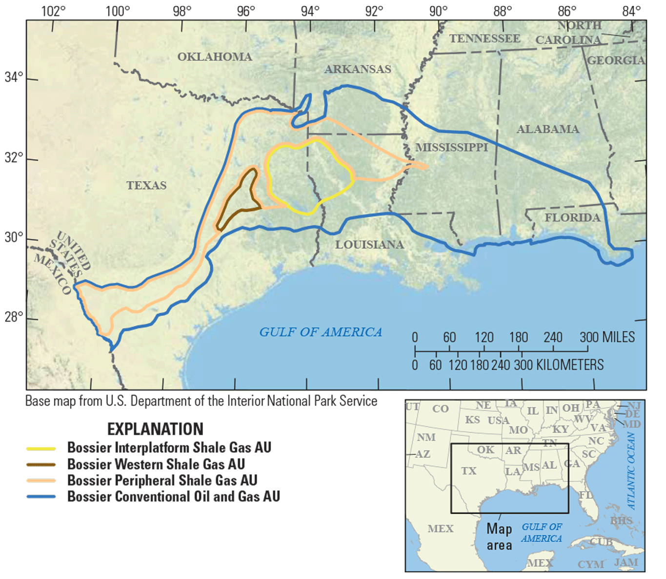
Map showing the location of three continuous and one conventional assessment units (AUs) in the Bossier Formation.
Total Petroleum System and Assessment Units
The USGS defined an Upper Jurassic–Cretaceous–Tertiary Composite Total Petroleum System (TPS) encompassing oil and gas throughout the Gulf Coast region. Gas in shales of the Bossier Formation may be mainly self-sourced but may also be augmented by gas from the underlying Smackover and Haynesville Formations. The Bossier Formation is widespread in the subsurface of Texas, Arkansas, Louisiana, Mississippi, Alabama, and Florida. The spatial extent of three continuous and one conventional assessment units (AUs) in the Bossier Formation was defined within the Upper Jurassic–Cretaceous–Tertiary Composite TPS based on differing aspects of geology, petroleum system elements, and technical drilling limits related to pressure and temperature (Whidden and others, 2023).
The Bossier Interplatform Shale Gas AU, which is the main area for shale gas production of the Bossier Formation, is largely defined by the boundary of the positive structural element of the Sabine Uplift (Cicero and Steinhoff, 2013). Horizontal drilling targets gas in fractured shales of the Bossier Formation throughout the uplift. The extent and density of fracturing may be related to structural movements of the Sabine Uplift. The geologic model for the Bossier Interplatform Shale Gas AU is for gas generated from shales of the Bossier Formation, possibly augmented by gas from the Smackover and Haynesville Formations, to be retained within the matrix and fractures of the shales of the Bossier Formation.
The Bossier Western Shale Gas AU is defined by a pod of highly overpressured shales in the Bossier Formation adjacent to faults defining the western margin of the East Texas Basin. Horizontal drilling has shown that parts of the Bossier Formation are characterized by substantial overpressure, where the overpressured shales are close to or exceeding the fracture gradient as interpreted from mud weight data (S&P Global Commodity Insights, 2025). This AU is commonly referred to as the “Western Haynesville” by industry (Wright, 2024; Morenne, 2025), but the gas is being produced from shales of the Bossier Formation according to an analysis of well logs, seismic data, and well landing zones. Production from the few wells drilled in this AU shows that estimated ultimate recoveries (EURs) are substantially higher than those of typical shales of the Bossier Formation (table 1). From an assessment perspective, given that few wells have been drilled in this AU, it was difficult to categorize the gas in this overpressured pod of shales in the Bossier Formation as being part of a conventional or a continuous gas accumulation. The decision was made to assess the western Bossier Formation as a continuous gas accumulation. The geologic model is for gas to be trapped in highly overpressured, fractured, high-temperature, organic-rich shales of the Bossier Formation.
Table 1.
Key input data for three continuous and one conventional assessment units in the Bossier Formation.[Gray shading indicates not applicable. The average estimated ultimate recovery (EUR) input is the minimum, mode, maximum, and calculated mean. AU, assessment unit; %, percent; MMBO, million barrels of oil; BCFG, billion cubic feet of gas]
The Bossier Peripheral Shale Gas AU is defined as the area of shale of the Bossier Formation outside of the areas of the Bossier Interplatform Shale Gas AU and Bossier Western Shale Gas AU. There is little drilling data from this AU, but the EURs are generally lower in this AU compared to the Bossier Interplatform Shale Gas AU, possibly due to a lower density of fractures. The geologic model is for gas sourced from shales of the Bossier Formation to be in the matrix and fractures, possibly along with gas from the Smackover and Haynesville Formations.
The Bossier Conventional Oil and Gas AU consists of sandstone and carbonate reservoirs in structural and stratigraphic traps sourced by several Jurassic source rocks in the Upper Jurassic–Cretaceous–Tertiary Composite TPS. The updip boundary of this AU is defined by the following: (1) where sandstones and carbonate reservoirs of the Bossier Formation have been eroded or are not present by nondeposition, (2) the downdip technical drilling limits, and (3) the boundary between State and Federal waters. Sandstone-rich depositional systems are prevalent in the Bossier Formation where paleofluvial systems prograded into the area (Snedden and Galloway, 2019). Stratigraphic facies changes, local salt tectonics, and faulting create the known trapping mechanisms in the Bossier Formation conventional reservoirs. The geologic model is for gas from the Bossier Formation, and possibly from the Smackover and Haynesville Formations, to have migrated updip into structural and stratigraphic traps. The general lack of sealing lithologies may be a limiting factor in the resource potential in this AU. The key input data for the four Bossier Formation AUs are shown in table 1 and Gardner (2026).
Undiscovered Resources Summary
The USGS quantitatively assessed three continuous and one conventional AUs for undiscovered oil, gas, and natural gas liquid resources in the Bossier Formation. The estimated mean total resources in the four AUs are 3 million barrels of oil (MMBO), with an F95–F5 range from 1 to 8 MMBO; 343,499 billion cubic feet of gas (BCFG), or 343.5 trillion cubic feet of gas, with an F95–F5 range from 103,943 to 611,703 BCFG; and 374 million barrels of natural gas liquids (MMBNGL), with an F95–F5 range from 109 to 721 MMBNGL (table 2).
Table 2.
Results for three continuous and one conventional assessment units in the Bossier Formation.[Gray shading indicates not applicable. Results shown are fully risked estimates. F95 represents a 95-percent chance of at least the amount tabulated; other fractiles are defined similarly. MMBO, million barrels of oil; BCFG, billion cubic feet of gas; NGL, natural gas liquids; MMBNGL, million barrels of natural gas liquids]
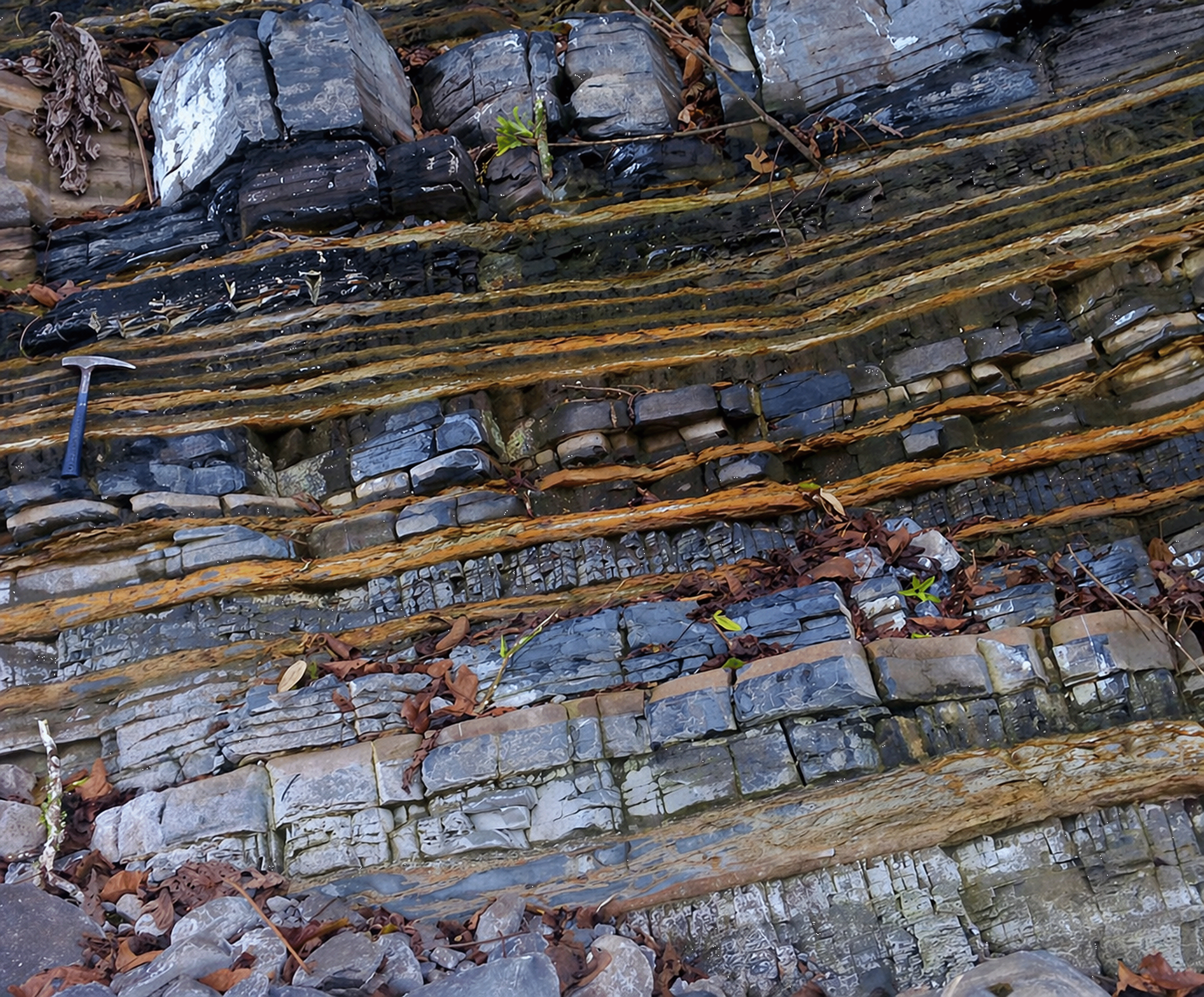
Photograph of an outcrop of the Bossier Formation-equivalent Pimienta Formation in the central Huayacocotla Basin, State of Hidalgo, Mexico, showing alternating limestone, bentonite, and organic-rich shale deposited in a semirestricted marine setting. The Bossier Formation is restricted to the subsurface of the United States; therefore, outcrops of equivalent strata in Mexico provide valuable observations not obtainable in the U.S. Gulf Coast region. Geology hammer shown for scale. Photograph by Mario Martínez-Yáñez, used with permission.
For More Information
Assessment results are also available at the USGS Energy Resources Program website, https://www.usgs.gov/programs/energy-resources-program.
Bossier Formation Assessment Team
Rand Gardner, Justin E. Birdwell, Jason A. Flaum, Scott A. Kinney, Janet K. Pitman, Stanley T. Paxton, Andrea D. Cicero, Jenny H. Lagesse, Jeffrey D. Pepin, John W. Counts, Benjamin G. Johnson, Celeste D. Lohr, Katherine J. Whidden, Katherine L. French, Tracey J. Mercier, and Heidi M. Leathers-Miller
References Cited
Cicero, A.D., and Steinhoff, I., 2013, Sequence stratigraphy and depositional environments of the Haynesville and Bossier shales, east Texas and north Louisiana, chap. 3 of Hammes, U., and Gale, J., eds., Geology of the Haynesville gas shale in east Texas and west Louisiana, U.S.A.: AAPG Memoir 105, p. 25–46, accessed December 13, 2025, at https://doi.org/10.1306/13441843M1053598.
Gardner, R., 2026, USGS National and Global Oil and Gas Assessment Project—Bossier Formation, Gulf Coast region—Assessment unit boundaries, assessment input data, and fact sheet data tables: U.S. Geological Survey data release, https://doi.org/10.5066/P14PGG8R.
Morenne, B., 2025, Jerry Jones says he has unlocked a $100 billion gas bounty in this drilling inferno: The Wall Street Journal, October 29, 2025, accessed December 13, 2025, at https://www.wsj.com/business/energy-oil/jerry-jones-comstock-resources-texas-f11636d6?reflink=desktopwebshare_permalink.
Paxton, S.T., Pitman, J.K., Kinney, S.A., Gianoutsos, N.J., Pearson, O.N., Whidden, K.J., Dubiel, R.F., Schenk, C.J., Burke, L.A., Klett, T.R., Leathers-Miller, H.M., Mercier, T.J., Haines, S.S., Varela, B.A., Le, P.A., Finn, T.M., Gaswirth, S.B., Hawkins, S.J., Marra, K.R., and Tennyson, M.E., 2017, Assessment of undiscovered oil and gas resources in the Bossier Formation, U.S. Gulf Coast, 2016: U.S. Geological Survey Fact Sheet 2017–3015, 2 p., accessed December 13, 2025, at https://doi.org/10.3133/fs20173015.
S&P Global Commodity Insights, 2025, Enerdeq US well history and production database: Englewood, Colo., S&P Global Commodity Insights, accessed December 13, 2025, at https://spglobal.com/commodityinsights. [Available from S&P Global Commodity Insights, 15 Inverness Way East, Englewood, CO 80112.]
Whidden, K.J., Birdwell, J.E., Gardner, R., Kinney, S.A., Paxton, S.T., Pitman, J.K., and Schenk, C.J., 2023, Assessment of continuous oil and gas resources in the Upper Jurassic Smackover Formation of the onshore U.S. Gulf Coast, 2022: U.S. Geological Survey Fact Sheet 2023–3021, 4 p., accessed December 13, 2025, at https://doi.org/10.3133/fs20233021.
Wright, B., 2024, Lateral completions a boon for Haynesville extension: Journal of Petroleum Technology, v. 76, no. 1, p. 34–38, accessed March 10, 2026, at https://doi.org/10.2118/0124-0034-JPT.
Disclaimers
Any use of trade, firm, or product names is for descriptive purposes only and does not imply endorsement by the U.S. Government.
Although this information product, for the most part, is in the public domain, it also may contain copyrighted materials as noted in the text. Permission to reproduce copyrighted items must be secured from the copyright owner.
Suggested Citation
Gardner, R., Birdwell, J.E., Flaum, J.A., Kinney, S.A., Pitman, J.K., Paxton, S.T., Cicero, A.D., Lagesse, J.H., Pepin, J.D., Counts, J.W., Johnson, B.G., Lohr, C.D., Whidden, K.J., French, K.L., Mercier, T.J., and Leathers-Miller, H.M., 2026, Assessment of undiscovered oil and gas resources in the Bossier Formation within the onshore United States and State waters of the Gulf Coast region, 2025: U.S. Geological Survey Fact Sheet 2026–3004, 4 p., https://doi.org.10.3133/fs20263004.
ISSN: 2327-6932 (online)
Study Area
| Publication type | Report |
|---|---|
| Publication Subtype | USGS Numbered Series |
| Title | Assessment of undiscovered oil and gas resources in the Bossier Formation within the onshore United States and State waters of the Gulf Coast Region, 2025 |
| Series title | Fact Sheet |
| Series number | 2026-3004 |
| DOI | 10.3133/fs20263004 |
| Publication Date | May 06, 2026 |
| Year Published | 2026 |
| Language | English |
| Publisher | U.S. Geological Survey |
| Publisher location | Reston VA |
| Contributing office(s) | Central Energy Resources Science Center |
| Description | Report: 4 p.; Data Release |
| Country | United States |
| State | Alabama, Arkansas, Florida, Louisiana, Mississippi, Texas |
| Other Geospatial | Bossier Formation, Gulf Coast region |
| Online Only (Y/N) | Y |