

The 3D Elevation Program—Supporting North Dakota’s Economy
Links
- Document: Report (426 KB pdf) , HTML , XML
- NGMDB Index Page: National Geologic Map Database Index Page (html)
- Download citation as: RIS | Dublin Core
Introduction
As the northernmost Great Plains State encompassing two geomorphological areas divided by the Missouri River, North Dakota has varied needs for high-resolution elevation data. The top industry in North Dakota is agriculture and related products, and the fastest growing sector is natural resources led by oil and gas extraction and mining, all of which contribute to the State’s economy (U.S. Department of Agriculture, National Agricultural Statistics Service, 2024b). High-resolution elevation data can be utilized to improve flood risk management, emergency response, flood and drainage modeling, water quality monitoring, invasive species control, and transportation infrastructure design (Dewberry, 2012). Critical applications that meet the State’s management needs depend on light detection and ranging (lidar) data that provide a highly detailed three-dimensional (3D) model of the Earth’s surface and aboveground features.
The 3D Elevation Program (3DEP; refer to sidebar) is managed by the U.S. Geological Survey (USGS) in partnership with Federal, State, Tribal, U.S. territorial, and local agencies to acquire consistent lidar coverage at quality level 2 or better (table 1) to meet the many needs of the Nation and North Dakota. The status of available and in-progress 3DEP baseline lidar data in North Dakota is shown in figure 1. 3DEP baseline lidar data include quality level 2 or better, 1-meter or better digital elevation models, and lidar point clouds, and must meet the Lidar Base Specification 2025 Rev. A (https://www.usgs.gov/3dep/lidarspec) or newer requirements . The National Enhanced Elevation Assessment (Dewberry, 2012) identified user requirements and conservatively estimated that availability of lidar data would result in at least $12.39 million in new benefits annually to the State. The top nine North Dakota business uses for 3D elevation data, which are based on the estimated annual conservative benefits of 3DEP, are shown in table 2.
Table 1.
Data quality levels, pulse spacing, and pulse density. Quality level 2 or better lidar data meet 3DEP requirements.[Specifications for quality level 0 (QL0) are from Heidemann (2012, p. 3 and table 1); for quality levels 1 and 2, specifications are from Sugarbaker and others (2014, table 1). In the quality level column, QL0 represents the highest level of quality. RMSEz, root mean square error in the elevation (z) dimension; cm, centimeter; m, meter; pls/m2, first return pulses per square meter; ≤, less than or equal to; ≥, greater than or equal to]
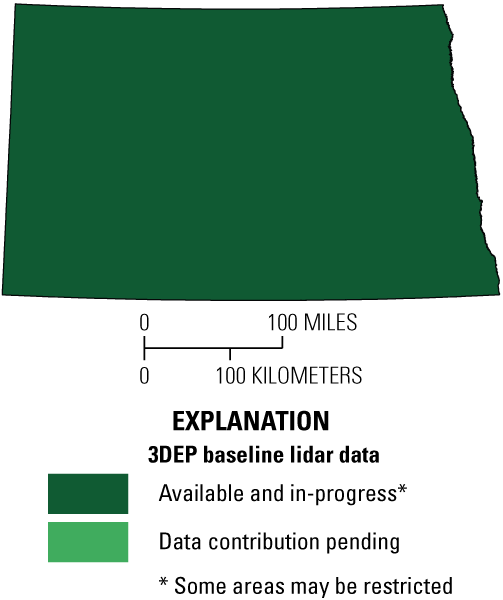
Map of North Dakota showing status of 3D Elevation Program (3DEP) baseline lidar data as of March 2026. Visit https://usgs.gov/NationalMap/LidarExplorer to find and download currently available data.
Table 2.
Conservative benefits estimates for the top nine North Dakota business uses of the proposed 3DEP data identified in the National Enhanced Elevation Assessment (Dewberry, 2012).Status of 3DEP in North Dakota
The North Dakota Department of Water Resources (NDDWR) has been involved with lidar activities since 2002, assuming a leadership role in data collection and dissemination for the State starting in 2013. Systematic statewide quality level 3 lidar collection began in 2008, driven by a need for flood-plain management along the Red River of the North, and was completed in 2016. The NDDWR pivoted to quality level 2 collection, completing acquisition in 2024, and quality level 1 collection is now underway for North Dakota’s 50 largest cities (NDDWR, 2025a). NDDWR’s primary partners in lidar acquisition are the Federal Emergency Management Agency (FEMA), the Natural Resources Conservation Service of the U.S. Department of Agriculture, and the USGS.
Agriculture and Precision Farming
In the agricultural sector, precision farming is a growing activity. Precision farming synthesizes data and models to maximize resources and minimize waste for the highest yield. The 2022 North Dakota Census of Agriculture showed that nearly 7,500 farms, from very small to very large, used precision farming practices (U.S. Department of Agriculture, National Agricultural Statistics Service, 2024a). Lidar underpins complex agricultural models involving nutrient and sediment runoff, areas of high erosion, and insolation levels, which are used in farm management activities such as drainage tile placement (Dewberry, 2022).
Flood Risk Management
Periodic major floods caused by snowmelt and ice jams occur on the Red, Souris, Missouri, James, and other rivers (National Oceanic and Atmospheric Administration, National Weather Service, undated). The NDDWR (2025b) estimates funding flood control efforts to cost more than $300 million from 2025 through 2027. Lidar is critical to modeling and managing flood risk and is a component of FEMA’s Base Level Engineering, which provides advanced flood hazard models, particularly for areas where detailed modeling and maps have not been compiled (NDDWR, 2021).
After a 1997 catastrophic flood on the Red River, North Dakota and Minnesota partnered with the U.S. Army Corps of Engineers to create the Fargo-Moorhead Area Diversion Project, a multipart structure that, once completed in 2027, is intended to divert floodwaters away from the heavily populated areas of Fargo and West Fargo. Its construction was only possible with detailed, high-quality elevation data and surface-water modeling (Metro Flood Diversion Authority, 2024).
Geologic Resource Assessment and Hazard Mitigation
Landslides are a semifrequent hazard in North Dakota, particularly in river valleys having unstable subsoils. Lidar is essential for identifying and monitoring areas that are conducive to landslides, especially as many of these areas are not easy to identify from aerial photography alone (Maike and Moxness, 2022; fig. 2). Natural resource extraction is the largest part of the State’s economy by GDP (U.S. Bureau of Economic Analysis, 2026). North Dakota’s critical minerals assessment program uses lidar and aerial imagery to determine the depths of mineral beds that are not readily accessible through exploratory drilling (Moxness, 2024).
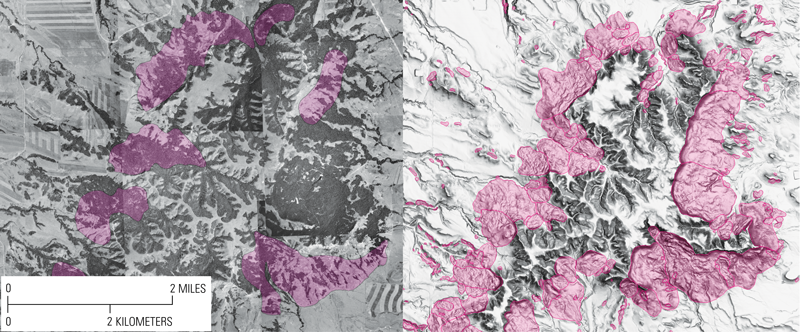
Landslide mapping methods of an area in the Killdeer Mountains in western North Dakota. A comparison between 1958 aerial photographs (left) and a lidar-derived shaded relief image (right) shows the increased identification of landslide areas (pink) using high-resolution lidar (Moxness, 2022).
3D Elevation Program (3DEP)
The 3D Elevation Program is managed by the U.S. Geological Survey (USGS) on behalf of the community of Federal, State, Tribal, local, and other partners and users of elevation data. In response to growing needs for high-quality elevation data, the goal of 3DEP is to complete acquisition of nationwide light detection and ranging (lidar) data (interferometric synthetic aperture radar [IfSAR] data in Alaska) to provide the first-ever national baseline of consistent, high-resolution topographic elevation data—both bare earth digital elevation models and 3D point clouds.
Benefits
-
• Economies of scale by acquiring data for larger areas.
-
• Predictable and flexible Federal investments that can reduce costs and allow better planning.
-
• Consistent national coverage that provides data for applications that span project, jurisdictional, and watershed boundaries.
-
• Simplified data acquisition that provides contracts, project management, quality assurance, and published data specifications.
-
• National benefits of $690 million per year conservatively, with the potential to generate $13 billion per year in additional benefits through applications that span the economy (Dewberry, 2012).
High-Quality Data and Products
3DEP lidar data provide coverage with a minimum of two points per square meter and a vertical error not to exceed 10 centimeters, measured as root mean square error in the elevation (z) dimension (RMSEz) (table 1). 3DEP baseline lidar data products include all data points collected (point clouds) and bare-earth digital elevation models with a 1-meter or better resolution. The USGS integrates the elevation data into The National Map. Data are available free of charge and without use restrictions. To download 3DEP products visit https://apps.nationalmap.gov/downloader/.
Ways to Participate
Participation in 3DEP is open to Federal, State, Tribal, U.S. territorial, and local government partners, as well as private sector partners, and offers the option to acquire even higher quality data. Partners may contribute funds toward projects managed by the USGS, or they may receive cooperative funds to manage their own projects. An annual Data Collaboration Announcement is the mechanism used to establish partner agreements. Organizations and the private sector may contribute existing data that meet 3DEP requirements. For more information refer to the 3DEP website at https://usgs.gov/3DEP/collaborate.
References Cited
Dewberry, 2012, National Enhanced Elevation Assessment final report (revised March 29, 2012): Fairfax, Va., Dewberry, 84 p. plus appendices, accessed January 20, 2025, at https://www.dewberry.com/services/geospatial/national-enhanced-elevation-assessment.
Dewberry, 2022, 3D Nation Elevation Requirements and Benefits Study Final Report: Fairfax, Va., Dewberry, 171 p. with appendices, accessed January 23, 2025, at https://www.dewberry.com/services/geospatial-mapping-and-survey/3d-nation-elevation-requirements-and-benefits-study.
Heidemann, H.K., 2012, Lidar base specification (ver. 1.2, November 2014): U.S. Geological Survey Techniques and Methods, book 11, chap. B4, 67 p. with appendices, accessed January 20, 2025, at https://doi.org/10.3133/tm11B4.
Maike, C., and Moxness, L., 2022, Identifying active landslides—Repeat LiDAR coverages allow remote sensing of slope movement: North Dakota Geological Survey Geo News, v. 49, no. 2, p. 5–11, accessed January 27, 2025, at https://www.dmr.nd.gov/dmr/ndgs/july-2022.
Metro Flood Diversion Authority, 2024, Permanent, reliable flood protection for the future of the Fargo-Moorhead area: Metro Flood Diversion Authority website, accessed January 23, 2025, at https://fmdiversion.gov.
Moxness, L.D., 2022, The first statewide landslide dataset—NDGS completes initial landslide mapping for North Dakota: North Dakota Geological Survey Geo News, v. 49, no. 1, p. 12–15, accessed January 30, 2025, at https://www.dmr.nd.gov/dmr/ndgs/january-2022.
Moxness, L.D., 2024, Designing a critical mineral drilling program: North Dakota Geological Survey Geo News, v. 51, no. 2, p. 5–9, accessed January 27, 2025, at https://www.dmr.nd.gov/dmr/ndgs/july_2024.
National Oceanic and Atmospheric Administration, National Weather Service, [undated], Flooding in North Dakota: National Weather Service website, accessed January 29, 2025, at https://www.weather.gov/safety/flood-states-nd.
North Dakota Department of Water Resources [NDDWR], 2021, Floodplain Management: North Dakota Department of Water Resources website, accessed January 29, 2025, at https://www.dwr.nd.gov/reg_approp/floodplain_management/.
North Dakota Department of Water Resources [NDDWR], 2025a, North Dakota LiDAR Dissemination MapService: North Dakota Department of Water Resources website, accessed January 27, 2025, at https://lidar.dwr.nd.gov.
North Dakota Department of Water Resources [NDDWR], 2025b, 2025 Water development plan executive summary: North Dakota Department of Water Resources website, accessed January 29, 2025, at https://www.dwr.nd.gov/info_edu/water_development_plan/.
Sugarbaker, L.J., Constance, E.W., Heidemann, H.K., Jason, A.L., Lukas, V., Saghy, D.L., and Stoker, J.M., 2014, The 3D Elevation Program initiative—A call for action: U.S. Geological Survey Circular 1399, 35 p., accessed January 20, 2025, at https://doi.org/10.3133/cir1399.
U.S. Bureau of Economic Analysis, 2026, Economic profile for North Dakota: U.S. Bureau of Economic Analysis website, accessed May 18, 2026, at https://apps.bea.gov/regional/bearfacts/.
U.S. Department of Agriculture, National Agricultural Statistics Service, 2024a, 2022 Census of agriculture: North Dakota state and county data AC-22-A-34, v. 1, part 34, accessed January 28, 2025, at https://www.nass.usda.gov/Publications/AgCensus/2022/Full_Report/Volume_1,_Chapter_1_State_Level/North_Dakota/ndv1.pdf.
U.S. Department of Agriculture, National Agricultural Statistics Service [USDA NASS], 2024b, North Dakota at a Glance: USDA NASS North Dakota office fact sheet, accessed May 14, 2024, at https://www.nass.usda.gov/Statistics_by_State/North_Dakota/Publications/Cooperative_Projects/ND%20at%20a%20Glance/At%20a%20Glance%202024.pdf.
U.S. Geological Survey, [undated], Lidar base specification online (rev. A, June 2025): U.S. Geological Survey website, accessed March 27, 2026, at https://www.usgs.gov/3dep/lidarspec.
For Further Information
Director, National Geospatial Program
U.S. Geological Survey, MS 511
12201 Sunrise Valley Drive
Reston, VA 20192
Email: [email protected]
USGS National Map Liaison:
Disclaimers
Any use of trade, firm, or product names is for descriptive purposes only and does not imply endorsement by the U.S. Government.
Although this information product, for the most part, is in the public domain, it also may contain copyrighted materials as noted in the text. Permission to reproduce copyrighted items must be secured from the copyright owner.
Suggested Citation
Guidero, E., 2026, The 3D Elevation Program—Supporting North Dakota's economy: U.S. Geological Survey Fact Sheet 2026-3006, 2 p., https://doi.org/10.3133/fs20263006.
ISSN: 2327-6932 (online)
Study Area
| Publication type | Report |
|---|---|
| Publication Subtype | USGS Numbered Series |
| Title | The 3D Elevation Program—Supporting North Dakota's economy |
| Series title | Fact Sheet |
| Series number | 2026-3006 |
| DOI | 10.3133/fs20263006 |
| Publication Date | June 17, 2026 |
| Year Published | 2026 |
| Language | English |
| Publisher | U.S. Geological Survey |
| Publisher location | Reston, VA |
| Contributing office(s) | National Geospatial Program |
| Description | 2 p. |
| Country | United States |
| State | North Dakota |
| Online Only (Y/N) | Y |
| Additional Online Files (Y/N) | N |