

The Great Lakes Geologic Mapping Coalition—Working Collaboratively to Understand the Geology of the Great Lakes Region
Links
- Document: Report (34 MB pdf) , HTML , XML
- NGMDB Index Page: National Geologic Map Database Index Page (html)
- Download citation as: RIS | Dublin Core
Introduction
The Great Lakes Geologic Mapping Coalition (GLGMC), commonly referred to as the “Coalition,” is a partnership between the U.S. Geological Survey (USGS), the U.S. States of Illinois, Indiana, Michigan, Minnesota, New York, Ohio, Pennsylvania, and Wisconsin and the Canadian province of Ontario. The member States receive funding for geologic mapping work from the USGS National Cooperative Geologic Mapping Program (NCGMP), whereas Ontario participates as a nonfunded partner. The mission of the GLGMC is to produce three-dimensional (3D) geologic maps that depict unconsolidated sediments and near-surface bedrock in the Great Lakes region of North America. Geologic maps are the basis of most earth science investigations and help support resource exploration (energy, minerals, groundwater), natural hazard mitigation, infrastructure development, and land-use planning, all of which can be used to advance economic development and strengthen national security in the Great Lakes region.
During the last few million years, the Great Lakes region has experienced repeated glacial advances and retreats, leaving behind extensive sediments, abundant natural resources, and widespread effects on the underlying bedrock geology (Swezey and others, 2022). Linked by shared histories of past glaciations, industrial agriculture, and legacy automotive, coal, steel, and manufacturing industries, the GLGMC member States collaborate to improve the understanding of the 3D distribution of the sediments overlying the region’s bedrock (fig. 1). Developing a comprehensive subsurface 3D framework of this glaciated terrain can provide earth science data to policymakers at all levels. These insights facilitate informed decisions on the exploration, use, and protection of vital resources, such as critical minerals, industrial materials, and aquifers, thereby supporting economic prosperity and the well-being of the citizens of this region.
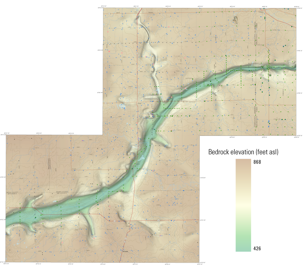
Detail from a bedrock elevation map generated during a joint investigation by the geological surveys of Indiana and Ohio (Rupp and others, 2021).
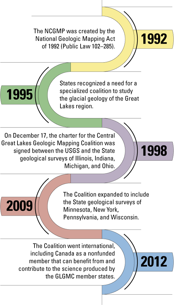
Since its inception in 1998, the Coalition has completed more than 100 geologic mapping projects across the Great Lakes region. Each project aims to deliver geologic maps, 3D datasets, and other information that improves understanding of the geology of the Great Lakes region, with an emphasis on economic and water resources. Key deliverables include 3D geologic maps and models typically portraying sediment thickness, often derived from top-of-bedrock and borehole data. These products are developed through a combination of fieldwork, subsurface modeling, and the collection and analysis of rock and sediment cores.
To support Coalition goals, member States collaborate with scientists working on related STATEMAP, EDMAP, and FEDMAP projects. Coalition scientists also engage with Tribal Nations in the Great Lakes region to ensure that Tribal interests pertaining to Coalition work are addressed. Through this collaboration, the Coalition unites the efforts of State, Federal, and Tribal Nation stakeholders to advance geologic data production and enhance understanding of the geologic resources of the Great Lakes region.
Minnesota Geological Survey Quaternary Geologic Mapping
The Minnesota Geological Survey (MGS) is carrying out a project called the County Geologic Atlas (CGA) program to support statewide groundwater management, mineral resource development, and civil engineering applications. As part of the CGA project, geologic mapping of surface and near-surface sediments relies on methods such as fieldwork, drilling, lithologic analyses, and geophysical surveys. With funding from the GLGMC, MGS staff analyze and correlate sediments in cores, which serve as benchmarks for cross sections (fig. 2) and geologic and groundwater models (fig. 3). The 1-kilometer cross sections, developed with GLGMC funding, help to identify and model subsurface sand bodies that may function as aquifers. Since 1995, the Minnesota Department of Natural Resources (DNR) has been partnering with the MGS on CGA reports. The geologic information provided in the MGS reports is used by the DNR to provide additional information on the groundwater conditions and contamination sensitivity of aquifers.
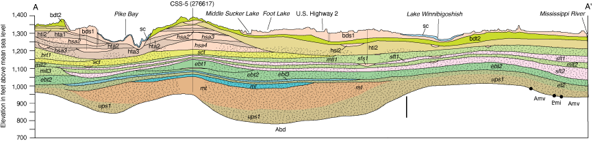
Cross section based on drill-hole and rotary-sonic core data depicting the distribution of unconsolidated sediments below the surface in Cass County, Minnesota (Lusardi and others, 2018).
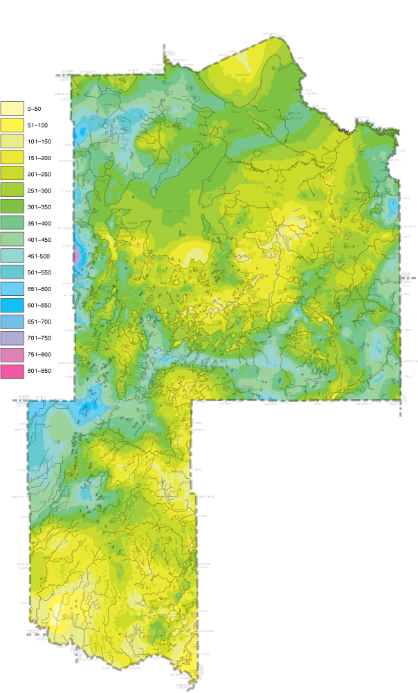
Depth to bedrock map produced as part of the Minnesota Geologic Atlas of Cass County, Minnesota (Lusardi and others, 2018).
Recently, the City of Motley in Cass County, Minnesota, used subsurface data from the MGS to identify a suitable location for a municipal water well. The data collected helped the city to save more than $700,000 in well-drilling costs (Barbara Lusardi, Minnesota Geological Survey, written commun., 2025). Additionally, MGS cross sections from the Washington County Geologic Atlas have been applied to groundwater flow modeling as part of remediation efforts addressing aquifer contamination.
In addition to partnering with member States, the MGS collaborates with Tribal Nations to complete mutually beneficial geologic mapping. For example, the Red Lake Band of Chippewa Indians, Minnesota, granted MGS permission to drill on Tribal land in Koochiching County, Minnesota, to support subsurface modeling efforts. This work, along with similar subsurface projects across the state, provides information about sediments not exposed at the surface, enabling geologists to develop comprehensive subsurface models. The modeling completed in Koochiching County could help the Tribe to make informed land-use decisions with potential benefits to their community and the surrounding region.
USGS Quaternary Geologic Mapping of the Glaciated Regions Project
A team of USGS geologists collaborates with the GLGMC to interpret the geological framework of the glaciated region of the United States, with particular emphasis on the area surrounding the Great Lakes. The USGS Quaternary Geologic Mapping of the Glaciated Regions Project, referred to as the “Glaciated Regions Project,” is currently (2026) focusing on detailed 1:24,000-scale Quaternary geologic mapping at Fort Drum in Jefferson and Lewis Counties, New York (fig. 4), and 1:100,000-scale geologic mapping in Dodge and Jefferson Counties, Wisconsin. The project addresses scientific challenges through innovative mapping approaches that provide societal and scientific benefits. Geological maps and associated products deliver data on aggregate (sand and gravel) resource potential, aquifer characteristics, groundwater contaminant pathways, sediment placer deposit potential for critical minerals, hazard potential for landslide and (or) slope failures, and improved delineation of the bedrock topography.
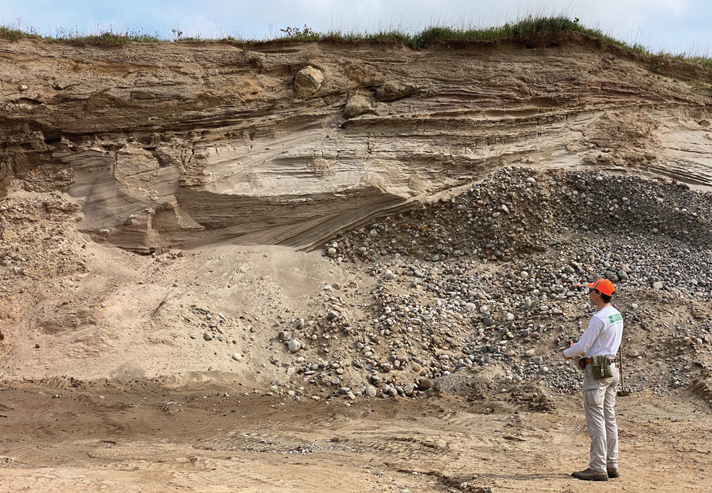
Photograph showing a U.S. Geological Survey (USGS) scientist analyzing an outcrop of sand and gravel in Fort Drum, New York. Photograph by G. Colip, USGS.
The USGS works toward strengthening the Nation’s resilience by applying its expertise in complex 3D glacial geology unique to the Great Lakes region, using both traditional geologic mapping techniques as well as new mapping technologies. The Glaciated Regions Project utilizes geophysical methods to characterize the subsurface, geochronologic analyses to determine how and when the sediments were deposited, and laboratory analyses to identify sediment properties and mineral content.
The Great Lakes region is home to 26 percent of the Nation’s population yet covers only 15 percent of its area (U.S. Census Bureau, Population Division, 2022). The region produces 21 percent of the Nation’s natural sand and gravel (U.S. Geological Survey, 2025), a resource extracted from glacial deposits, resulting in a lower cost per ton compared to material derived from States outside the region. Currently, quantified sand and gravel aggregate resources do not include materials within extensive aquifers and recharge areas that supply major population centers such as New York City and Chicago. The Great Lakes region also contains 35 percent of the Nation’s Superfund sites (U.S. Environmental Protection Agency, 2024) because of its history as an early industrial powerhouse due to its geologic resources, underscoring the need for geologic characterization and quantification.
References Cited
Lusardi, B.A., Pettus, M.C., Chandler, V.W., Radakovich, A.L., Nguyen, M.K., Staley, A.E., Hamilton, J.D., 2018, C-43, Geologic Atlas of Cass County, Minnesota: Minnesota Geological Survey County Atlas Series C-43, 6 pls., scale 1:200,000, accessed July 26, 2025, at https://conservancy.umn.edu/items/a64a453b-61a3-4b60-822d-f2a074639eef.
Rawling, J.E., III, Carson, E.C., Attig, J.W., Mickelson, D.M., Mode, W.N., Johnson, M.D., and Syverson, K.M., 2025, Quaternary geology of Wisconsin: Wisconsin Geological and Natural History Survey map 512, scale 1:500,000, accessed April 30, 2026, at https://doi.org/10.54915/xqpw9883.
Rupp, R.F., Tripp, D.C., Loope, H.M., Antinao, J.L., Johnson, M.R., Nash, T.A., and Norris, T.A., 2021, Bedrock elevation of the Berne, Domestic, Geneva, and Willshire 7.5‑minute quadrangles, Indiana–Ohio: Indiana Geological and Water Survey, Indiana Journal of Earth Sciences, v. 3, scale 1:48,000, at https://doi.org/10.14434/ijes.v3i1.31742.
Swezey, C.S., Blome, C.D., Kincare, K.A., Lundstrom, S.C., Stone, B.D., Sweetkind, D.S., Berg, R.C., Brown, S.E., and Yellich, J.A., 2022, Implementation plan of the National Cooperative Geologic Mapping Program strategy—Great Lakes (Central Lowland and Superior Upland Physiographic Provinces): U.S. Geological Survey Open-File Report 2021–1120, 24 p., accessed July 2025 at https://doi.org/10.3133/ofr20211120.
U.S. Census Bureau, Population Division, 2022, Annual estimates of the resident population for the United States, Regions, States, District of Columbia, and Puerto Rico—April 1, 2020, to July 1, 2022, NST-EST2022-POP: U.S. Census Bureau database, accessed December 16, 2022, at https://www2.census.gov/programs-surveys/popest/tables/2020-2022/state/totals/NST-EST2022-POP.xlsx.
U.S. Environmental Protection Agency, 2024, Search for Superfund sites where you live: U.S. Environmental Protection Agency website, accessed December 10, 2024, at https://www.epa.gov/superfund/search-superfund-sites-where-you-live.
U.S. Geological Survey, 2025, USGS aggregates time series data by State, type, and end use: U.S. Geological Survey data set, accessed April 24, 2025, at https://www.usgs.gov/media/files/usgs-aggregates-time-series-data-state-type-and-end-use.
For more information, please contact:
GLGMC Program Officer
GLGMC@usgs.gov
U.S. Geological Survey
National Cooperative Geologic Mapping Program
12201 Sunrise Valley Drive, Mail Stop 913
Reston, Virginia 20192
Publishing support provided by the U.S. Geological Survey, Science Publishing Network, Baltimore and Reston Publishing Service Centers
Edited by Bree McCloskey
Illustration support and layout by David Bruce
Disclaimers
Any use of trade, firm, or product names is for descriptive purposes only and does not imply endorsement by the U.S. Government.
Although this information product, for the most part, is in the public domain, it also may contain copyrighted materials as noted in the text. Permission to reproduce copyrighted items must be secured from the copyright owner.
Suggested Citation
Lopez, B., Shelton, J.L., Marketti, M., Ritzel, K., and Graham, B.L., 2026, The Great Lakes Geologic Mapping Coalition—Working collaboratively to understand the geology of the Great Lakes Region: U.S. Geological Survey Fact Sheet 2026–3010, 4 p., https://doi.org/10.3100/fs20263010.
ISSN: 2327-6932 (online)
ISSN: 2327-6916 (print)
Study Area
| Publication type | Report |
|---|---|
| Publication Subtype | USGS Numbered Series |
| Title | The Great Lakes Geologic Mapping Coalition—Working collaboratively to understand the geology of the Great Lakes Region |
| Series title | Fact Sheet |
| Series number | 2026-3010 |
| DOI | 10.3133/fs20263010 |
| Publication Date | May 20, 2026 |
| Year Published | 2026 |
| Language | English |
| Publisher | U.S. Geological Survey |
| Publisher location | Reston, VA |
| Contributing office(s) | National Cooperative Geologic Mapping |
| Description | 4 p. |
| Country | Canada, United States |
| State | Illinois, Indiana, Michigan, Minnesota, New York, Ohio, Pennsylvania, Wisconsin |
| Online Only (Y/N) | N |
| Additional Online Files (Y/N) | N |