

Assessment of Undiscovered Continuous and Conventional Oil and Gas Resources in the Woodford and Barnett Shales of the Permian Basin Province, Texas and New Mexico, 2025
Links
- Document: Report (6.60 MB pdf) , HTML , XML
- Data Release: USGS data release - USGS National and Global Oil and Gas Assessment Project—Permian Basin Province, Woodford Shale and Barnett Shale Conventional and Continuous Assessment Unit Boundaries, Assessment Input Data, and Fact Sheet Data Tables
- NGMDB Index Page: National Geologic Map Database Index Page (html)
- Download citation as: RIS | Dublin Core
Abstract
Using a geology-based assessment methodology, the U.S. Geological Survey estimated undiscovered, technically recoverable mean continuous and conventional resources of 1.6 billion barrels of oil and 28.3 trillion cubic feet of gas in the Woodford and Barnett Shales of the Permian Basin Province.
Introduction
The U.S. Geological Survey (USGS) assessed undiscovered, technically recoverable continuous and conventional oil and gas resources in the Middle to Late Devonian Woodford Shale (Ruppel and others, 2020a) and Mississippian Barnett Shale of the Permian Basin Province in western Texas and southeastern New Mexico (fig. 1A, B). For this study, the USGS defined nine total assessment units (AUs): four continuous AUs and one conventional AU for the Woodford Shale and four continuous AUs for the Barnett Shale (fig. 1A, B). The Woodford and Barnett Shales were previously assessed by the USGS in 2007 (Schenk and others, 2008).
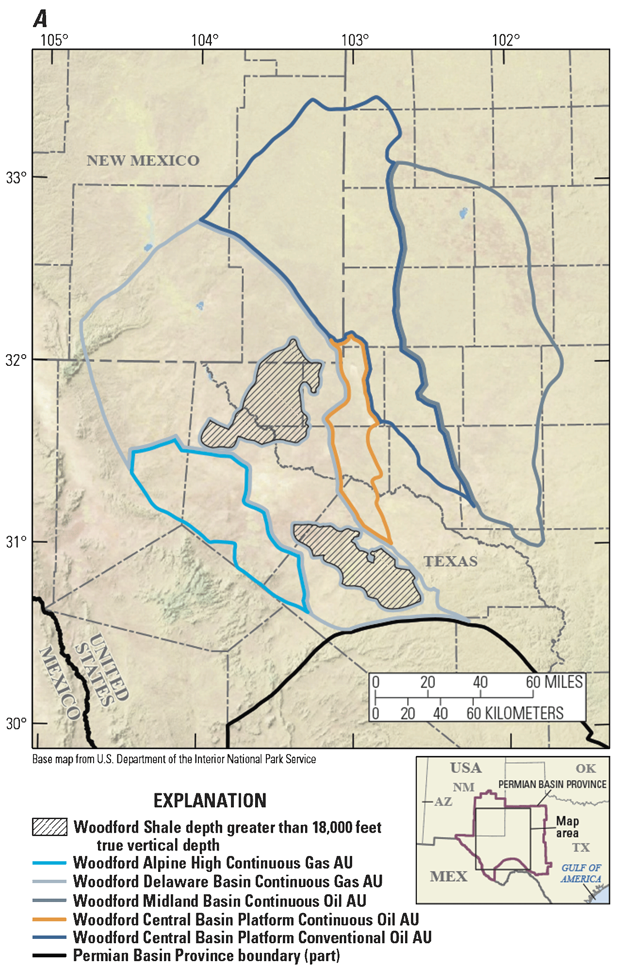
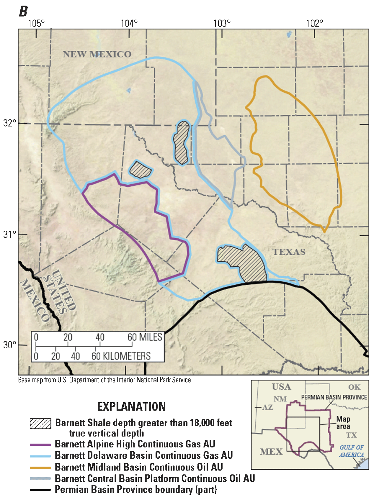
Maps showing the locations of (A) four continuous and one conventional assessment units (AUs) in the Woodford Shale and (B) four continuous AUs in the Barnett Shale of the Permian Basin Province.
Geologic Summary
A widespread Devonian marine transgression across the North American craton created anoxic bottom-water seas and resulted in the deposition of organic-matter-rich biosiliceous mudstones of the Woodford Shale (Ruppel, 2019). Subsequent sea-level fall during the Early Mississippian led to exposure, erosion, and periods of nondeposition. Renewed sea-level rise during the Middle to Late Mississippian resulted in the development of a large, rimmed carbonate platform and coeval deposition of basinal, organic-rich mudstones of the Barnett Shale (Ruppel, 2019). After the deposition of the Barnett Shale, the Permian Basin region transitioned to an active tectonic phase in which there was renewed collision of Gondwana and Laurentia, causing uplift, deformation, and erosion of both units (Ruppel, 2019).
The Woodford Shale has a maximum thickness of 900 feet (ft) and is variably porous (as much as 10 percent) and highly quartzose (50−90 percent; Ruppel and others, 2020a). In the distal southern Permian Basin Province, the quartz is mostly biogenic in origin, and clay content is low (10−35 percent; Ruppel and others, 2020a). In the proximal north, detrital quartz and clays are more prevalent (20−50 percent; Ruppel and others, 2020a). The Barnett Shale has a maximum thickness of 700 ft, is generally less porous (3−6 percent) than the Woodford Shale, and comprises mainly quartz and clays, with biogenic silica more prevalent to the south and detrital quartz to the north (Ruppel and others, 2020b). Quartz origin and clay content in both units affect facies and AU definitions: biosiliceous quartz and low clay content are representative of euxinic environments and higher organic richness, whereas the presence of clay-rich detrital quartz facies reflects an oxic, organic-poor environment. The presence of fractures, potentially from Late Mississippian to Pennsylvanian tectonism, likely enhances the reservoir quality of both formations.
The Woodford and Barnett Shales serve as both primary source rock and reservoir. Given their depositional histories, both the Woodford and Barnett Shales are considered Type II marine organic systems, with total organic carbon (TOC) content as high as 8 weight percent (wt. pct.) in the Barnett Shale and 14 wt. pct. in the Woodford Shale (Cicero, 2022), and both have a range of thermal maturities from immature oil to dry gas. As of November 2025, production is concentrated along the edges of the Delaware and Midland Basins and structural highs of the Central Basin Platform. Biomarker studies have shown that hydrocarbons generated from the Woodford and Barnett Shales have also migrated into overlying conventional reservoirs (Echegu, 2013; Spence, 2024).
Total Petroleum System and Assessment Units
The USGS defined four continuous and one conventional AUs for the Woodford Shale: the Woodford Alpine High Continuous Gas AU, Woodford Delaware Basin Continuous Gas AU, Woodford Midland Basin Continuous Oil AU, Woodford Central Basin Platform Continuous Oil AU, and Woodford Central Basin Platform Conventional Oil AU (fig. 1A, B). Four continuous AUs were defined for the Barnett Shale: the Barnett Alpine High Continuous Gas AU, Barnett Delaware Basin Continuous Gas AU, Barnett Midland Basin Continuous Oil AU, and Barnett Central Basin Platform Continuous Oil AU (fig. 1A, B). All the AUs are within the Permian Basin Paleozoic Composite Total Petroleum System (Schenk and others, 2008). Criteria used to define these AUs include the following: thickness of the source or reservoir greater than (>) 50 ft, favorable gross depositional environment or facies, TOC content >2 wt. pct., a range of thermal maturation windows that define oil and gas (vitrinite reflectance [Ro] between 0.6 and 1.3 percent for oil, and >1.3 percent for gas), and a drilling depth cutoff of 18,000 ft true vertical depth (TVD), which corresponds to the approximate limit of current (2010–24) successful onshore horizontal drilling, based on data from S&P Global Commodity Insights (2024).
Woodford Shale
Two continuous gas AUs were defined for the Woodford Shale: the Woodford Alpine High Continuous Gas AU and the Woodford Delaware Basin Continuous Gas AU. The external boundary of the Woodford Delaware Basin Continuous Gas AU is defined by thermal maturity values for gas (Ro>1.3 percent) and the presence of basinal shale facies. The internal boundaries of this AU are defined by a depth cutoff at the top of the Woodford Shale at 18,000 ft TVD. The structurally high productive area known as the Alpine High is located within the same maturation values as the Woodford Delaware Basin Continuous Gas AU but is defined as a separate AU. It is bounded to the west by the limits of gas maturity and facies type, and to the north, south, and east by the presence of a series of faults that define a steep structural dip basinward. The southern limit of the Woodford Alpine High Continuous Gas AU is further defined by the presence of dry holes.
Two continuous oil AUs were defined for the Woodford Shale: the Woodford Midland Basin Continuous Oil AU and the Woodford Central Basin Platform Continuous Oil AU. The western edge of the Woodford Midland Basin Continuous Oil AU is defined by structure and faulting, and the north and east are defined by thickness and favorable depositional facies. Two wells produce and are testing the eastern and southern limits of the Woodford Shale in this AU. The Woodford Central Basin Platform Continuous Oil AU is bounded to the west and south by the change in thermal maturities from gas prone to oil prone, and to the north and east by structure, faults, and areas of erosion. Several wells produce from the Woodford Shale in this AU; however, Parker and others (2014) suggest this area is less likely to be productive because of low maturities, low pressures, and high viscosities of oil.
One conventional AU was defined for the Woodford Shale: the Woodford Central Basin Platform Conventional Oil AU. This AU is flanked on the west and south by the Woodford Delaware Basin Continuous Gas AU and the Woodford Central Basin Platform Continuous Oil AU, and to the east by the Woodford Midland Basin Continuous Oil AU. The northern boundary is delineated by thickness and where TOC content is less than 2 wt. pct. The only Woodford Shale producer in the entirety of this AU, and all of New Mexico, is the Angel 2 well at Gladiola Field (Broadhead, 2010). Given the lack of production and uncertainty of the presence and quality of the reservoir rocks, considerable risk was applied to this AU (table 1).
Table 1.
Key input data for nine assessment units in the Woodford and Barnett Shales of the Permian Basin Province.[Gray shading indicates not applicable. The average estimated ultimate recovery (EUR) input is the minimum, mode, maximum, and calculated mean. AU, assessment unit; %, percent; BCFG, billion cubic feet of gas; MMBO, million barrels of oil]
Barnett Shale
Two continuous gas AUs were defined for the Barnett Shale: the Barnett Alpine High Continuous Gas AU and the Barnett Delaware Basin Continuous Gas AU. The external boundary of the Barnett Delaware Basin Continuous Gas AU is primarily defined by thermal maturity values for gas (Ro>1.3 percent) and the presence of basinal shale facies. The internal boundaries of this AU are defined by a depth cutoff on the top of the Barnett Shale at 18,000 ft TVD. The structurally high productive area known as the Barnett Alpine High Continuous Gas AU has been differentiated from the Barnett Delaware Basin Continuous Gas AU by the limits of gas maturity and facies type in the west, and by the presence of a series of faults that define a steep structural dip basinward in the north, east, and southeast.
Two continuous oil AUs were defined for the Barnett Shale: the Barnett Midland Basin Continuous Oil AU and the Barnett Central Basin Platform Continuous Oil AU. The Barnett Central Basin Platform Continuous Oil AU is defined by the change in thermal maturity from gas prone to oil prone to the west and by erosion to the north, east, and south. Barnett Shale exploration in this area is minimal; however, production in the neighboring Barnett Midland Basin Continuous Oil AU has been steadily increasing since 2013 (S&P Global Commodity Insights, 2024). Most of the activity is concentrated along the western edge of the basin, where thermal maturities, thickness, drilling depth, and facies are favorable for oil production. The southern extent of the AU is defined by erosion, and the eastern extent is defined by thickness. The Barnett Shale, like the Woodford Shale, thins considerably to the east in the Midland Basin. The interfingering of carbonates in the northern area of the Barnett Midland Basin Continuous Oil AU, which is unique to the Barnett Shale, may also enhance the ability to hydraulically fracture this formation. The input data for all AUs are summarized in table 1 and Cicero (2026).
Undiscovered Resources Summary
The USGS quantitatively assessed undiscovered continuous and conventional oil and gas resources in nine AUs in the Woodford and Barnett Shales of the Permian Basin Province (table 2). The fully risked, estimated mean totals are 1,625 million barrels of oil (MMBO), or 1.6 billion barrels of oil, with an F95–F5 range from 470 to 2,928 MMBO; 28,259 billion cubic feet of gas (BCFG), or 28.3 trillion cubic feet of gas, with an F95–F5 range from 8,098 to 51,706 BCFG; and 813 million barrels of natural gas liquids (MMBNGL), with an F95–F5 range from 236 to 1,469 MMBNGL.
Table 2.
Results for nine assessment units in the Woodford and Barnett Shales of the Permian Basin Province.[Gray shading indicates not applicable. Results shown are fully risked estimates. F95 represents a 95-percent chance of at least the amount tabulated; other fractiles are defined similarly. MMBO, million barrels of oil; BCFG, billion cubic feet of gas; NGL, natural gas liquids; MMBNGL, million barrels of natural gas liquids]
For More Information
Assessment results are also available at the USGS Energy Resources Program website, https://www.usgs.gov/programs/energy-resources-program.
References Cited
Cicero, A.D., 2022, Compilation of thermal maturity and source rock geochemistry data from the Permian Basin Province, west Texas and southeast New Mexico: U.S. Geological Survey data release, accessed December 16, 2022, at https://doi.org/10.5066/P9KQU1XK.
Cicero, A.D., 2026, USGS National and Global Oil and Gas Assessment Project—Permian Basin Province, Woodford Shale and Barnett Shale conventional and continuous assessment unit boundaries, assessment input data, and fact sheet data tables: U.S. Geological Survey data release, https://doi.org/10.5066/P13P5ZGT.
Parker, A., Entzminger, D., Leone, J., Sonnenfeld, M., and Canter, L., 2014, Lessons learned from the KCC #503H Woodford horizontal well at Keystone South Field, Winkler County, TX: AAPG Search and Discovery, article 20254, 18 p., accessed January 4, 2021, at https://www.searchanddiscovery.com/documents/2014/20254parker/ndx_parker.pdf.
Ruppel, S.C., 2019, Anatomy of a Paleozoic basin—The Permian Basin, USA—Introduction, overview, and evolution, chap. 1 of Ruppel, S.C., ed., 2019, Volume 1 of Anatomy of a Paleozoic basin—The Permian Basin, USA: The University of Texas at Austin, Bureau of Economic Geology Report of Investigations 285, AAPG Memoir 118, p. 1–27.
Ruppel, S.C., Rowe, H., Reed, R., Barrick, J.E., James, E.W., and Loucks, R.G., 2020a, The Woodford Formation of the Permian Basin—Regional, Middle to Late Devonian transgression of the southern midcontinent and accompanying global anoxia, chap. 16 of Ruppel, S.C., ed., 2020, Volume 2 of Anatomy of a Paleozoic basin—The Permian Basin, USA: The University of Texas at Austin, Bureau of Economic Geology Report of Investigations 285, AAPG Memoir 118, p. 75–124.
Ruppel, S.C., Rowe, H., Reed, R., and Loucks, R.G., 2020b, The Mississippian System in the Permian Basin—Proximal platform carbonates and distal organic-rich mudrocks, chap. 17 of Ruppel, S.C., ed., 2020, Volume 2 of Anatomy of a Paleozoic basin—The Permian Basin, USA: The University of Texas at Austin, Bureau of Economic Geology Report of Investigations 285, AAPG Memoir 118, p. 125–158.
S&P Global Commodity Insights, 2024, Enerdeq US well history and production database: Englewood, Colo., S&P Global Commodity Insights, accessed December 15, 2024, at https://spglobal.com/commodityinsights. [Available from S&P Global Commodity Insights, 15 Inverness Way East, Englewood, CO 80112.]
Disclaimers
Any use of trade, firm, or product names is for descriptive purposes only and does not imply endorsement by the U.S. Government.
Although this information product, for the most part, is in the public domain, it also may contain copyrighted materials as noted in the text. Permission to reproduce copyrighted items must be secured from the copyright owner.
Suggested Citation
Cicero, A.D., Schenk, C.J., Lagesse, J.H., Johnson, B.G., Mercier, T.J., Leathers-Miller, H.M., Gelman, S.E., Hearon, J.S., and Le, P.A., 2026, Assessment of undiscovered continuous and conventional oil and gas resources in the Woodford and Barnett Shales of the Permian Basin Province, Texas and New Mexico, 2025: U.S. Geological Survey Fact Sheet 2026–3059, 4 p., https://doi.org/10.3133/fs20263059.
ISSN: 2327-6932 (online)
Study Area
| Publication type | Report |
|---|---|
| Publication Subtype | USGS Numbered Series |
| Title | Assessment of undiscovered continuous and conventional oil and gas resources in the Woodford and Barnett Shales of the Permian Basin Province, Texas and New Mexico, 2025 |
| Series title | Fact Sheet |
| Series number | 2026-3059 |
| DOI | 10.3133/fs20263059 |
| Publication Date | January 14, 2026 |
| Year Published | 2026 |
| Language | English |
| Publisher | U.S. Geological Survey |
| Publisher location | Reston VA |
| Contributing office(s) | Central Energy Resources Science Center |
| Description | Report: 4 p,; Data Release |
| Country | United States |
| State | New Mexico, Texas |
| Other Geospatial | Woodford and Barnett Shales |
| Online Only (Y/N) | Y |