

Presented Abstracts from the U.S. Geological Survey 2020 Rocky Mountain Region Science Exchange (September 15–17, 2020)
Links
- Document: Report (2.55 MB pdf) , HTML , XML
- Download citation as: RIS | Dublin Core
Acknowledgments
We would like to acknowledge and express our gratitude to the Rocky Mountain Region Science Exchange Planning Committee for their successful planning and hosting of the 2020 Rocky Mountain Region Science Exchange and regional leaders who provided support while encouraging the committee to follow the various inspirations to make this virtual conference a success. We express our appreciation to all the presenters and their coauthors who shared their science, participated in panel discussions and breakouts sessions, contributed abstracts and suggestions to formulate session purpose and objectives, and responded to numerous polls and practice sessions. Finally, we are grateful for the thoughtful comments and thorough review of this report by Meghan Dick and David Dean (U.S. Geological Survey)
Abstract
The U.S. Geological Survey Rocky Mountain Region hosted scientists, managers, program coordinators, and leadership team members for a virtual Science Exchange during September 15–17, 2020. The Science Exchange had 216 registered participants and included 48 talks over the 3-day period. Invited speakers presented information about the novel U.S. Geological Survey Earth Monitoring, Analysis, and Prediction (EarthMAP) concept. Scientists showcased their research and participated in discussions related to the EarthMAP concept and EarthMAP applications. In addition, the Colorado River Basin Pilot Project, one of the first EarthMAP Pilot Projects, was unveiled during the Science Exchange. This report provides synopses of session objectives and corresponding abstracts that were presented along with author affiliations and email address of the lead author. In addition, web links are provided for related programs and projects, and associated publications are referenced.
Introduction
The primary theme of the Rocky Mountain Region (RMR) 2020 Science Exchange (SE) was based on Earth Monitoring, Analyses, and Prediction (EarthMAP). EarthMAP was initiated by the U.S. Geological Survey (USGS) in 2019 to design and build approaches to integrate science with advanced technologies, and to connect USGS and stakeholder datasets with predictive models to deliver actionable information at the scales and timeframes needed to inform decisions. The EarthMAP theme for the RMR 2020 SE was suggested by the RMR Director’s Office and the EarthMAP program management team to build on existing momentum by familiarizing scientists with the EarthMAP concept and soliciting useful or enlightening input from those scientists. The RMR leadership convened the Science Exchange Planning Committee (table 1) to plan for a virtual meeting and to define the workshop objectives and session themes, identify and invite speakers and science presenters, and organize panel discussions. The Science Exchange agenda was based on presentation nominations from USGS Center Directors that best reflected EarthMAP characteristics, existing capacities, or potential use cases. The planning committee identified 35 nominated science presentations and developed the Science Exchange agenda (table 2). Most of the science presentations focused on current science efforts in the Colorado River Basin (fig. 1) or science that could be applied to the Colorado River Basin. The Science Exchange was an ideal setting to announce the EarthMAP-based Colorado River Basin Pilot Project because USGS scientists attending the meeting were the target demographic invited to join the pilot.
Table 1.
Rocky Mountain Region 2020 Science Exchange Planning Committee.[RMR, Rocky Mountain Region; SE, Science Exchange]
Table 2.
Agenda for the Rocky Mountain Region Science Exchange.[SEPC, Science Exchange Planning Committee; EarthMAP, Earth Monitoring, Analysis, and Prediction]
Purpose and Scope
This report is intended to accompany the USGS Circular “Rocky Mountain Region Science Exchange 2020-EarthMAP and the Colorado River Basin” (Tillery and others, 2022), which summarizes the planning, organization, and realization of the RMR SE as well as discussions and outcomes from session presentations, panel discussions, and the Colorado River Basin Pilot breakout sessions. The intended outcome of this report is to be used as supplemental information by the USGS Colorado River Basin Pilot team to engage and inform partners, stakeholders, and the public about the existing programs and science capacity of USGS in the Colorado River Basin and those programs and capacities that could be applied to support the Colorado River Basin Pilot Project. This report includes submitted abstracts for science talks presented during the RMR SE but does not include abstracts associated with keynote and introductory presentations or progress updates associated with EarthMAP.
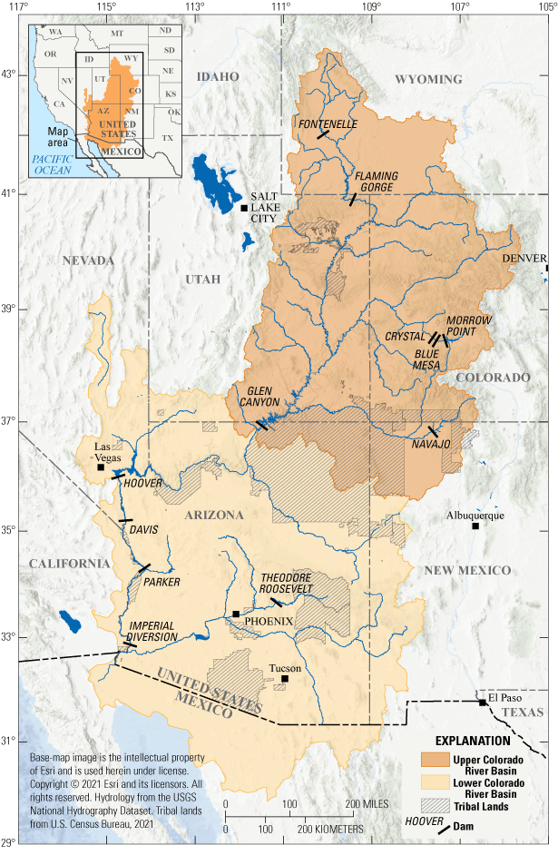
Map showing the location of the Upper and Lower Colorado River Basins.
Session Objectives and Presented Abstracts
Session objectives and abstracts are presented in this section in the same order as the agenda (table 2). The presenting author’s email address and USGS office affiliation is provided in table 3, which also follows the presentation order based on the agenda. The presenting author is provided first, and all coauthors and their affiliations accompany each abstract.
Table 3.
Presenting author’s email address and affiliation for the 2020 Rocky Mountain Region Science Exchange.[Authors are listed in the same order as presentations in table 2.]
Session 1: Setting the Stage
The objective of this introductory session was to provide background information on the history, vision, and need for EarthMAP. Examples of datasets already in use that were similar or relevant to the EarthMAP concept were presented. This session was divided into two sub-sessions: (1A) Examples of Large Science Data and their Role in EarthMAP, and (1B) The Future of Data Delivery.
Session 1A: Examples of Large Science Data and their Role in EarthMAP
This session was designed to provide examples of the USGS producing relevant science at large scales. The objective of this session was to use these existing examples to explore the challenges associated with the delivery of large data streams and the building of robust models that provide timely projections for decision makers. This session should help begin the conversation about the requirements needed for EarthMAP to integrate existing enterprise-level monitoring and data delivery systems with models that synthesize information across domains taking these and other existing USGS capacities to the next functional level.
Frontiers of Land Change Science
By Peter Doucette (USGS)
Growing demands for understanding changes on the Earth’s land surface are fueling a new generation of products and services that can contribute significantly to recognizing patterns of land change over time. To meet these needs, the USGS Earth Resources Observation and Science Center (EROS) is developing the Land Change Monitoring, Assessment, and Projection capability at a national scale, which can contribute significantly to the land surface component of the EarthMAP vision. A fundamental philosophy of the Land Change Monitoring, Assessment, and Projection product, besides detecting and monitoring land change over time, is that the drivers of change also need to be interpreted and understood to develop robust models that can provide timely projections of land change for decision makers. This talk addressed the science and technology considerations needed to fully realize this vision.
Supplemental Information
Land Change Monitoring, Assessment, and Projection (LCMAP)—website, https://www.usgs.gov/special-topics/lcmap.
Landscape-Scale Changes Within Sagebrush Ecosystems—Linking Resources and Wildlife
By Cameron L. Aldridge (USGS)
Ecosystems around the globe are continually threatened by anthropogenically induced changes. Conservation of these ecosystems and the services they provide are often dependent on our understanding of how these systems are changing and how this change affects species dependent on those resources for survival and persistence. Sagebrush ecosystems of the western Unites States have been drastically altered over the last century, with less than half of the ecosystem remaining. Threats persist today that continue to remove intact sagebrush or degrade ecosystem function. Explicitly tracking those changes over time and linking to population outcomes for species of concern could aid in management and conservation efforts. The USGS has recently developed spatial products that characterize changes in sagebrush vegetation components, from 1984 to present, and compiled population data for the Centrocercus urophasianus (greater sage-grouse), an icon of the sagebrush ecosystem. This talk demonstrated how these novel approaches for developing such rare datasets, across space and time, are currently being used to assess ecosystem-level changes and an early warning system for sage-grouse populations. This presentation also included approaches to integrate these datasets, along with additional characterizations of disturbances (for example, fire and invasive plants), and climate to better guide conservation and management efforts.
U.S. Geological Survey Advanced Integrated Fire Science: Enhanced Prediction of Post-Fire Hazards for Risk Assessments and Decision Making
By Rachel A. Loehman and Paul Steblein (both USGS)
Wildfires have long-term economic and social impacts on people―causing the loss of property, livelihoods, and lives―yet fire in wildlands is essential to reduce future wildfire risk, improve wildlife habitat, maintain or restore ecological resilience, and manage fire-adapted species in many ecosystems across the United States. Administrative orders and national strategies prioritize active management and technological support to reduce wildfire risk. One of the greatest unmet needs was identified as actionable science information and tools to assess vulnerabilities and mitigate direct and indirect fire risks before, during, and after wildfires. The USGS is perfectly positioned to meet this need, based on its expertise in a diversity of fire and hazard-related sciences that are actively used to address challenges in wildland fire science and management across the Nation. However, the USGS’s many fire science capabilities require integration in order to support truly actionable management applications and decision making. A key area for integration is between predictive models for fire occurrence and severity and the potential for post-fire debris flows, and associated changes in water quality and quantity. The USGS Advanced Integrated Fire Science team developed a unique and forward-looking assessment and prediction framework that will enhance the ability of the wildland fire and emergency management communities to protect the safety, health, and prosperity of communities, minimize economic losses and ecosystem damages, and enhance post-fire mitigation and recovery. This interdisciplinary, cross-mission area systems development and science integration effort (with external partners from the wildland fire community) enables the USGS to deliver actionable information across the wildland fire cycle and demonstrate the potential of the EarthMAP initiative. Our initial effort applying this approach is proposed for the Gunnison Basin, Colorado, with subsequent expansion occurring across the western United States.
Session 1B: The Future of Data Delivery
One aspiration of EarthMAP is to provide near real-time Earth science data products for use by decision makers that manage resources and respond to immediate and long-term hazards such as fire, floods, drought, and sea-level rise. Two USGS organizational units that have helped meet this aspiration are the Office of Science Quality and Integrity and the Community for Data Integration (CDI). The fundamental science practices (FSP) administered through the Office of Science Quality and Integrity is the foundation that ensures the excellence of USGS science products. The technological innovations, edge-of-the-envelope thinking, and inclusivity that characterize CDI have resulted in better communication infrastructure and integration capacities.
Supplemental Information
Office of Science Quality and Integrity—website, https://www.usgs.gov/office-of-science-quality-and-integrity.
U.S. Geological Survey Fundamental Science Practices and EarthMAP
By Harry Jenter (USGS)
USGS FSP underpin the reputation of USGS science for excellence and objectivity. The FSP uses policy and guidance to clarify how USGS science is carried out and how the resulting information products, including maps, imagery, data, and publications, are developed, reviewed, approved, and released. Put simply, FSP are a set of philosophies, policies, and operational procedures intended to maximize and protect the value of USGS science. As the USGS takes on increasingly larger Earth science activities such as EarthMAP, possibly one of USGS’s most extensive and collaborative science frameworks to date, FSP will need to evolve to meet many new challenges. These potentially include enormous data volumes, diverse data types, complex interagency partnerships, new information product categories, and emerging innovations in publishing. Existing resources, such as the USGS Fundamental Science Practices Advisory Council, the team of Bureau Approving Officials and a Policy Analyst in the OSQI, and the USGS Science Publishing Network, position the USGS to evolve FSP in ways that meet these challenges and preserve the reputation of USGS for unbiased science.
Supplemental Information
Fundamental Science Practices (USGS)—website, https://www.usgs.gov/office-of-science-quality-and-integrity/fundamental-science-practices.
Office of Science Quality and Integrity—website, https://www.usgs.gov/office-of-science-quality-and-integrity.
The Community for Future Data Integration
By Leslie Hsu (USGS)
The ability to integrate diverse USGS data is a critical aspect of the transdisciplinary EarthMAP vision. One way to achieve the forums and activities necessary for cross-disciplinary communication and data integration is through communities of practice. A community of practice is a group of people who share a concern or a passion for something they do and learn how to do it better as they interact regularly. Often, researchers and practitioners lack a venue for frequent interaction and learning outside of their particular center or program. To help fill this gap, the USGS CDI provides an open forum for solving data challenges in integrated science. The CDI hosts monthly virtual meetings, focused collaboration groups, an annual proposals process, and workshops and training events. All activities and topics are member-driven to meet current needs. Common activities include piloting new technologies in the USGS computational ecosystem, providing training in high-demand data skills, and engaging with partners to solve broad data challenges. The CDI facilitates the building capabilities and knowledge that is aligned with the EarthMAP vision of open, interoperable, modular components. Everyone is encouraged to seek out a CDI group or other community of practice where the discussions and activities will help one’s own work and large-scale, integrative science.
Supplemental Information
Community for Data Integration (USGS)—website, https://www.usgs.gov/centers/community-for-data-integration-cdi.
Session 2: Rocky Mountain Region Science Related to EarthMAP Themes
This session was designed to be a transition from the EarthMAP concept and introductory presentations to the RMR science presentations and to show how current project science is relevant to EarthMAP. The science products and information that USGS Science Centers produce are the fundamental building blocks needed to support EarthMAP. The objective of this session was to demonstrate to the Science Exchange attendees how diverse USGS projects each have a potential role in supporting EarthMAP. The desired outcome of this session was to encourage attendees to start thinking about how their science projects can meet their program and stakeholder needs as well as support the EarthMAP concept, and to show examples of how that might look.
The Next Generation Water Observing Systems Upper Colorado River Basin Water Isotope Network (WIN)
By Carleton Bern (USGS)
The Water Isotope Network (WIN) is a new effort to monitor naturally occurring water isotopes in surface water and precipitation in a 46,000 square kilometer (17,800 square mile) study area of the Upper Colorado River Basin. The WIN is supported by the USGS Water Mission Area’s Next Generation Water Observing Systems (NGWOS) effort, which aims to foster innovation and development of monitoring technologies leading to more types of hydrologic data at higher temporal and spatial frequencies. The broader goal of NGWOS is to use these new datasets to facilitate the prediction of interactions between climate, surface water, groundwater, and soil moisture across large watersheds. Stable water isotopes of oxygen and hydrogen can trace multiple processes and patterns that are relevant to such predictions. Decades of research in a variety of settings have used water isotopes to trace processes like evaporation and to separate stormflow and base flow in surface waters. By using water isotopes on large spatial scales in the Upper Colorado River Basin, patterns of isotopes in precipitation across elevation gradients and shifts in the seasonal composition of precipitation have the potential to help unravel travel times to surface water and proportional importance of recharge and contributing areas. Currently (2020), the monitoring locations and strategies of the WIN are being designed. One technology to be tested is real-time monitoring of water isotopes at a streamgage on the Colorado River using a cavity ring-down spectrometer. Though challenges will abound, such a strategy is within the capability of current technology. The resulting high temporal resolution (hourly) data will dramatically increase the ability to translate water isotope patterns into hydrologic understanding. A real-time data stream, like those provided for discharge, will facilitate the incorporation of isotopes into predictive water availability modeling. The goal of the WIN will be to transition water isotopes from being a research tool to regular application for understanding and prediction of water resources. Through new instrumentation and other components of the WIN, the predictive capability of water isotope data for hydrology could be realized for NGWOS and other USGS efforts that focus on monitoring, analysis, and prediction.
Supplemental Information
Next Generation Water Observing System—Upper Colorado River Basin, https://www.usgs.gov/mission-areas/water-resources/science/next-generation-water-observing-system-upper-colorado-river?qt-science_center_objects=0#qt- science_center_objects.
Subsurface Mapping at Societally Relevant Scales Using Airborne Electromagnetics (AEM)
By Burke Minsley and Lyndsay B. Ball (both USGS)
Earth’s subsurface hosts the groundwater, mineral, and energy resources that sustain life and society, is the foundation to landscapes that support diverse ecosystems and productive agricultural systems where much of the natural and human-made environment is vulnerable to impacts from human activity, natural hazards, and climate change. Despite its importance, our ability to characterize the subsurface geology and aquifer systems beneath us—particularly over large areas and with high spatial resolution—has been limited by a lack of mature and cost-effective technologies. Recent advances in airborne geophysics, in particular airborne electromagnetic (AEM) instruments and software tools, are changing this reality. Much like light detection and ranging (lidar) and other remote sensing technologies that have transformed how we interpret the geomorphological processes that have shaped Earth’s surface, AEM surveys are rapidly becoming a foundational tool for extending our view into the subsurface. AEM surveys are being used to map geological and hydrological properties from 10s to 100s of meters (m) below ground from watershed to basin scales. AEM data uniquely fill a critical gap between sparse boreholes and extensive but depth-limited remote sensing observations. AEM surveys have been used in support of studies that span every USGS mission area and in cooperation with numerous local and Federal stakeholders. Here, we summarize several case studies that showcase AEM capabilities for mapping subsurface geology and hydrogeology that may be an important foundation for future EarthMAP-scale studies.
Integrated Groundwater and Surface Water Availability in the Upper Colorado River Basin
By Melissa D. Masbruch, Jesse Dickinson, Donald Sweetkind, Casey Jones, Kendall FitzGerald, Patrick Longley, and David Selkowitz (all USGS)
A coupled groundwater and surface water flow model of the Upper Colorado River Basin is being constructed to investigate groundwater and surface water availability as an integrated resource. Previous USGS research suggests that groundwater discharge provides about half of the surface water in the Colorado River Basin. The objectives of the study are to: (1) quantify the current status of groundwater and surface water resources and how these resources have changed through time, (2) improve conceptual and numerical models of groundwater and surface water interactions (feedback) in this region, and (3) predict possible changes in groundwater storage and discharge to surface water caused by human water use and variable climate conditions. This study, through its integration of many hydrologic processes and simulations, will support and benefit many USGS objectives, including EarthMAP. The model and the study results are anticipated to be published by the end of fiscal year 2022.
Supplemental Information
GSFLOW—Coupled Groundwater and Surface-Water Flow Model, https://www.usgs.gov/software/gsflow-coupled-groundwater-and-surface-water-flow-model#:~:text=Overview%20of%20GSFLOW,2005%20and%20MODFLOW%2DNWT
Geospatial Analyses and Applications Lab
By Dan K. Jones, Stephanie Gordon, Annie L. Putman, and Brianna Williams (all USGS)
The USGS Geospatial Analyses and Applications Lab (GAAL) is primarily focused on providing geospatial analyses and tools to better account for place-based phenomena. Scientists at GAAL have experience across a broad range of projects and topics as geographers that provides a unique lens to view collaborative and integrative science across multiple spatial and temporal scales. The GAAL scientists utilize geospatial software (for example, ArcGIS Desktop) and statistical software (for example, R) to identify landscape gradients and unravel complex source-sink relationships between observational data and landscape characteristics. Our group has a strong background in database creation, organization, and upkeep to address issues related to geospatial data, which tends to be multi-sourced, cumbersome, and often difficult to work with. Recent group efforts are focused on learning and adjusting to ScienceBase and Department of the Interior data standards. The GAAL scientists have developed several online and tablet-based applications that help coordinate field sampling efforts, track samples throughout their journey from the field to the laboratory, and provide rich visualizations to map, query, and access approved data. In the past, many projects have focused on place-based activities, conducting valuable science to gain a deep, nuanced understanding of the system under study. More recently there has been a call for broadly focused, integrative science to support regional and national needs. Tools and methods developed by the GAAL are well suited for finding unique ways to translate place-based activities to broader needs. The GAAL scientists able to capitalize on key variables of importance learned from past work in place-based activities to (1) develop new geospatial relationships to inform metric development, (2) map key variables across broad spatial extents, (3) apply relationships developed at local-scales to broad-scales via shared variables, and (4) investigate the strength of broad relationships to feedback on place-based findings. These relationships can also be used to guide future site selections or result extrapolation.
The Nationwide Geologic Synthesis: A New and Improved Geologic Map for the Nation
By R. Randall Schumann, Ren Thompson, Donald Sweetkind, and Joseph Colgan (all USGS)
The development of a seamless, queryable, national geologic map is fundamental to USGS mission goals, for high-priority activities such as EarthMAP. Existing geologic maps at a national scale are too generalized to be useful, and local and State level maps are often inconsistent with each other and difficult to easily use in an assessment or modeling environment. The Nationwide Geologic Synthesis project was initiated to address these needs, with a long-term goal of building seamless, queryable, digital maps and subsurface models of geology for the United States at a more detailed scale (nominally about 1:100,000), and with more detailed information about each map unit, than any previous national and most State geologic maps. The primary creators of new geologic maps in the United States are the USGS National Cooperative Geologic Mapping Program and State geological surveys, but geologic maps and subsurface geologic models are also created by other Federal agencies, universities, and by several other programs/mission areas in the USGS. Therefore, an important role of the Nationwide Geologic Synthesis project is coordination and collaboration with our USGS colleagues and these Federal and State partners. The database will be developed in sections from these multiple sources and stitched into the national framework as the pieces become available. By crowdsourcing the best available geologic mapping across the country, we plan to build a modern, seamless, national geologic database that will be continuously updated as new maps becomes available.
Supplemental Information
National Cooperative Geologic Mapping Program—website, https://www.usgs.gov/programs/national-cooperative-geologic-mapping-program.
Session 3: Assessing Drivers of Change and Integrating Science—Model Approaches for EarthMAP
Drought, invasive plants, energy development, mining, recreation, and other competing land uses are drivers of change being studied by USGS scientists in the Rocky Mountain and Southwest Regions. USGS scientists are using modeling and a broad range of other analytical procedures and tools to understand drivers of change and predict outcomes of these changes. The purposes of this session were (1) to learn about the approaches used by USGS scientists in the Rocky Mountain and Southwest Regions that involve environmental drivers and landscape change, and the spatial and temporal scales being addressed; and (2) to learn how project science is helping stakeholders with decision making.
Predicting the Potential Distribution and Abundance of Invasive Species
By Catherine Jarnevich, Ian Pearse, Janet Prevéy, Helen Sofaer (all USGS), and Peder Engelstad (Colorado State University, Fort Collins, CO)
Invasive species can be agents of change, transforming ecosystems by altering ecosystem processes and ecosystem states. Groups tasked with managing invasive species on Federal lands are hampered by the scope of the invasive species problem compared to resources available to combat invasive species. Habitat suitability models for invasive species can provide practitioners with information to advise watch lists and target population searches. While many suitability models exist, there is often a divide between researchers creating these models and practitioners who may find them useful in informing land management actions. We formed a scientist-practitioner partnership to create national models for several high-priority species with the Invasive Species Habitat Tool (INHABIT), a web application displaying visual and statistical summaries of nationwide habitat suitability models. Species are identified by Department of the Interior land management agencies, and models are based on aggregated location data combined with environmental information including climate, soils, land cover, and human impact data. INHABIT provides practical information to enhance land management actions, including mapped products with interactive thresholds to define suitability based on management objectives, information on modeled environmental relationships, and tabular proximity summaries to inform management area watch lists. We are currently developing models where invasive species are most abundant and are having the most impact. These data can feed into other activities directly assessing impacts of invasive species on ecosystem processes. Based on comments and suggestions of practitioners, INHABIT and other efforts are actively evolving to help bridge the gap between science and land management.
Supplemental Information
Invasive Species Habitat Tool (INHABIT)—website, https://gis.usgs.gov/inhabit/.
Quantifying Probable Impacts of Oil and Gas Development
By Darius Semmens, Jay Diffendorfer, Seth Haines, and Karen E. Jenni (all USGS)
USGS oil and gas assessments follow an established and standardized methodology that produces probabilistic estimates of the recoverable resource. While these resource assessments are widely respected and applied around the world, they only consider one component of complex coupled human-natural systems. Comparable assessments of colocated biophysical resources and their socioeconomic benefits have not been established, making it difficult to anticipate the potential impacts of energy resource development. We present an approach to using USGS probabilistic energy resource assessments as a starting point for considering broader impacts across multiple resources of value to society. Using a Monte Carlo-based approach, we consider how the uncertain location and amount of infrastructure needed to develop an energy resource may interact with existing socio-ecological systems to develop an understanding of the probable impacts associated with resource development. Our approach simulates the spatial placement of infrastructure (roads and well pads) needed to develop an energy resource and the associated land change is then used as input for a variety of biophysical models to assess potential impacts. Using many iterations of infrastructure placement on the landscape we can develop aggregate measures of the probable impacts, including uncertainty. The approach provides flexibility to consider management alternatives, such as wells-per-pad requirements and spatial configurations of surface occupancy regulations, at different levels of spatial resolution. We present several different applications of this general approach to model integration to demonstrate its application for multiple resource assessment and the creation of actionable intelligence for resource managers.
Development and Application of a Watershed-Scale Precipitation-Runoff Modeling System Model and Streamflow Projections for the Upper Rio Grande Basin
By Shaleene B. Chavarria and C. David Moeser (both USGS)
A calibrated Precipitation-Runoff Modeling System (PRMS) model was developed to simulate naturalized streamflow conditions as part of the Upper Rio Grande focus area study. The model, which extends from the headwaters of the Rio Grande River in Colorado to Fort Quitman, Texas, offers insight into the magnitude of anthropogenic influence on streamflow in the basin. The PRMS model has led to integrated projects with the South Central Climate Adaptation Science Center and the Bureau of Reclamation. Downscaled climate projections provided by the South Central Climate Adaptation Science Center were used as inputs to the PRMS model to simulate projected streamflow through 2099 for the Rio Grande River and its tributaries. An analysis of changes in the timing and magnitude of streamflow in the basin is currently in progress using the PRMS model. The projected streamflow is also being used as input to an operational river routing model to assess the effects of projected streamflow under different water management scenarios in the Rio Grande Basin study. The Rio Grande Basin study is a stakeholder-driven study, funded by the Bureau of Reclamation, that aims to develop climate adaptation strategies to address the large and growing gap between water supply and demand in the Rio Grande Basin. The multiple projects stemming from the Rio Grande focus area study exemplify the importance of integrating multiple models, data sources, and a range of stakeholders in the basin including Federal, State, Tribal, and environmental organizations.
Supplemental Information
Precipitation Runoff Modeling System (PRMS) —website,
Interdisciplinary Investigations of Natural and Legacy-Mining-Related Metal Contributions to Streams in Mineralized Mountain Watersheds in Colorado
By Andrew H. Manning (USGS), Richard Wanty (USGS), Jean M. Morrison (USGS), Rob Runkel (USGS), Katie Walton-Day (USGS), Ben N. McGee (USGS), Burke J. Minsley (USGS), Lyndsay B. Ball (USGS), Robert D. Charnock (Colorado School of Mines), and William R. Gnesda (USGS)
Numerous headwater catchments in the mountains of Colorado contain zones of sulfide-rich, hydrothermally altered bedrock that generate runoff with elevated metal concentrations attributable to both natural weathering and mining-related sources. These mineralized watersheds present a water quality concern for downstream habitats and water resources, particularly in light of recent studies suggesting a potential increase in metal mobilization under warmer and drier climatic conditions. Two current USGS projects based in the Geology, Geophysics, and Geochemistry Science Center are performing integrated research to address this concern. The Multi-Scale Screening of Legacy Mine Sites project is aimed at developing a science-based approach for identifying legacy mine sites where substantial improvement of stream habitat health could be achieved with limited remediation efforts. A geographic information system screening tool to identify such sites, has been developed for Central Colorado incorporating multiple datasets from USGS and others (for example, water chemistry data, the USGS Mineral Deposit Database project [USMIN], and hydrothermal alteration mineral mapping from hyperspectral data). Field investigations are being conducted at candidate sites to determine effective field data collection approaches for the first-order characterization of mining-related and background metal sources and to further improve the geographic information system-based screening process. The second project, “Metal Transport in Mineralized Mountain Watersheds,” is designed to better understand controls on natural sulfide weathering processes and further enable model prediction of stream metal concentrations under changing climatic conditions. Airborne and ground geophysical surveys, geologic mapping, borehole geologic/geophysical logging, and discrete-depth groundwater chemical and isotopic data are all being used together to thoroughly characterize the bedrock mineralogy (surface and subsurface) and groundwater hydrogeochemical system in Redwell Basin, Colorado, a mineralized alpine watershed. Study sites for both projects are in the Upper Colorado River Basin, and our focus on applying interdisciplinary approaches to understand and manage surface water quality conditions runs parallel to stated EarthMAP program objectives.
Supplemental Information
Metal Transport in Mineralized Mountain Watersheds—website, https://www.usgs.gov/centers/gggsc/science/metal-transport-mineralized-mountain-watersheds?qt-science_center_objects=0#qt-science_center_objects.
Multi-Scale Screening of Legacy Mine Sites—website, https://www.usgs.gov/centers/geology%2C-geophysics%2C-and-geochemistry-science-center/science/multi-scale-screening?qt-science_center_objects=0#qt-sci ence_center_objects.
USMIN Mineral Deposit Database—website, https://www.usgs.gov/centers/gggsc/science/usmin-mineral-deposit-database?qt-science_center_object=&qt-science_center_objects=3#qt-science_center_obje cts.
Wind Erosion and Dust: Linking Climate, Land-Use, Air Quality, Snowpack, and Water Availability in the Colorado River Basin
By Mike Duniway and Travis Nauman (both USGS)
Erosion by wind is one of the principal processes associated with land degradation in drylands globally and is a significant concern to land managers and policymakers in the Colorado River Basin. This presentation provides a short overview of wind erosion issues in the southwestern United States and recent research relevant to the Colorado River Basin. In the drylands of the southwestern United States, millions of tons of soil are lost to wind erosion annually, much of which likely occurs on arid federally managed lands with fragile soils. Although climate change is a broad issue driving dust emission, growing evidence indicates that human disturbance of landscapes may be an even larger driver that acts synergistically with drought in increasing dust emission. Dryland soils are often stable when intact but disturbances including fire, domestic livestock grazing, oil and gas development and off-highway vehicles can increase horizontal aeolian flux by an order of magnitude, in some cases as much as forty fold. A growing body of literature documents the large-scale impacts of deposited dust changing the albedo of mountain snow cover and in some cases reducing Colorado River water supplies by approximately 5 percent. This presentation also introduced information on a new project that is designed to integrate land surface, atmospheric, and hydrologic processes in the Weather Research and Forecasting model, using remote sensing products to evaluate controls of these processes over the 57-year Landsat archive. A primary objective of this project is to better quantify the interactions of surface disturbance from human land use (for example, livestock grazing, off-pavement vehicle use, energy development, mining) and drought as primary drivers of dust creation on snow dynamics and related water-cycle impacts, as opposed to either factor alone. Clarifying the roles of drought and land disturbance can support smart land and water resource management in a region already outgrowing the current water supply.
Supplemental Information
Wind Erosion and Dust Emissions on the Colorado Plateau, Southwest Biological Science Center—website, https://www.usgs.gov/centers/southwest-biological-science-center/science/wind-erosion-and-dust-emissions-colorado?qt-science_center_objects=0#qt-scien ce_center_objects.
Critical Mineral Deposits in the Colorado River Basin and Evaluating the Risk of Mining
By Jeffrey L. Mauk, John D. Horton, Carma A. San Juan, Nick A. Karl, Jonathan A. Funk, William Gnesda, Margaret Hammond, Liam D. Knudsen, Amanda L. Ringer, Alex J. Schwarz, and Bradley S. Van Gosen (all USGS)
Earth resources provide the raw materials that are needed to address humankind’s greatest problems. Our technology-driven, knowledge-based society, with its increasing focus on green energy, is driving unprecedented demand for critical minerals that are imported to the United States. The western United States is comparatively rich in mineral deposits, and many of those have a long legacy of mining. The USGS Mineral Deposit Database project (USMIN) is documenting the locations and size of critical mineral deposits in the United States and its territories. We are also documenting the location of sites with former or current mining-related activities in the conterminous United States. To date, USMIN has published databases on 8 of the 35 United States critical minerals that were listed in a 2018 Federal Register announcement (Department of the Interior, 2018), and progress toward completing several others is well advanced. Of these, arsenic, cobalt, gallium, germanium, niobium, platinum group elements, rare earth elements, rhenium, tin, titanium, tungsten, uranium, and vanadium have significant deposits in the Colorado River Basin. Some of these deposits currently supply critical minerals, and others may be important for future generations, so knowledge of their location, size, and extent is essential for informed land-management decisions. Mining activities can create physical to environmental hazards. The USMIN databases allow quantification of mining-related features on the landscape that can help inform risk assessments and can help focus efforts to prioritize remediation efforts.
Supplemental Information
USMIN Mineral Deposit Database—website, https://www.usgs.gov/centers/gggsc/science/usmin-mineral-deposit-database?qt-science_center_object=&qt-science_center_objects=3#qt-science_center_obje cts.
Hotter Drought as a Driver of Rapid Forest and Watershed Change—Scaling from Local Landscapes to Global Networks
By Craig D. Allen (USGS)
Place-based field stations put scientists in the field with land managers enabling collaborative work opportunities. The USGS and National Park Service colocated New Mexico Landscape Field station in northern New Mexico has resulted in the development of uniquely intensive and diverse, landscape-scale, long-term, ecological and hydrological monitoring and research in the Jemez Mountains. Research has been centered on Bandelier and Valles Caldera National Park Service units since 1986. This location includes one of the world’s most intensively sampled dendroecological landscapes. Tree-ring sampling and analysis is used to reconstruct histories of forest growth, climate (winter versus monsoonal precipitation), fire, streamflow, and insect outbreaks that date back over 1,000 years. The regional emergence of a chronic, hotter drought around 2000 has transformed these National Park Service units into a particularly dynamic landscape, subject to increasingly extreme ecological disturbance processes (such as forest die-offs, insect outbreaks, fire, floods, and debris flows). Multiple USGS-led, long-term, multidisciplinary place-based research in local, New Mexico landscapes have provided: (1) direct science support to land managers (including seven Native American Tribes) and society to address many applied research questions, and (2) opportunities to codevelop broader collaborative research networks with diverse scientists near and far, thereby upscaling our joint datasets to address emerging regional, national, and global scientific-frontier challenges. These collaborative approaches and efforts have the potential to serve as an EarthMAP case study as they demonstrate how long-term, local, integrative USGS research on the dynamic interactions among forests-water-climate-disturbances provides key scientific insights into accelerating drivers of forest and watershed change. When incorporated into broader multidisciplinary research networks, this integrative USGS research contributes substantially to addressing critical uncertainties regarding the fate of the Earth’s forests, along with associated ecosystem services.
Session 4: EarthMAP Components in the Colorado River Basin and Beyond—Minerals, Metals, Climate, and Water
Presentations in this session demonstrated the diverse disciplines and science topics in which USGS scientists are currently engaged that are relevant to EarthMAP and the Colorado River Basin. The variety of topics and the interdisciplinary aspects of the science involved are a reminder that collaboration and integrative science will play a key role in the future of the USGS and EarthMAP approaches.
Evaluating the Impacts of Climate Change, Drought, and Irrigated Agriculture in the Colorado River Basin Using SPARROW
By Olivia Miller (USGS)
The southwestern United States relies on the Colorado River to sustain its ecosystems, communities, and economies. Climate change and drought threaten water supplies while salinity in the Colorado River Basin causes an estimated $300 to $400 million per year in economic damages. In light of these challenges, we present two projects focused on (1) bracketing potential future streamflow under climate change and drought, and (2) understanding temporal variation in salinity loading from irrigated agricultural lands in the Colorado River Basin. For the first project, USGS scientists estimate future streamflow in seven water resource regions in the Southwest using a new spatially referenced regressions on watershed (SPARROW) streamflow model. We present streamflow projections corresponding to input data from seven climate models and two greenhouse representative concentration pathways, RCP4.5 and RCP8.5, for three, thirty-year intervals centered on the 2030s, 2050s, and 2080s, and for a historic thirty-year interval centered on the 1990s. Results indicate widespread changes in streamflow, with 51 percent of RCP4.5 models and 67 percent of RCP8.5 models indicating decreases in streamflow by the 2080s. Among these models, results indicate the risk of 35–80 percent decreases in streamflow from historic values in all water resource regions for the 2080s, and maximum streamflow decreases from 20–45 percent at sites along the Colorado River that are used for measuring compliance with interstate and international water agreements. For the second project, we discuss the use of a temporally dynamic SPARROW model to estimate dissolved solids loads with time. Both project approaches highlight the relevance and applicability of SPARROW modeling to support EarthMAP.
Supplemental Information
Spatially referenced regressions on watershed attributes (SPARROW)—website, https://www.usgs.gov/mission-areas/water-resources/science/sparrow-modeling-estimating-nutrient-sediment-and-dissolved?qt-science_center_objects=0#qt- science_center_objects.
Seamless Geologic Mapping of the Lower Colorado River Corridor
By Ryan Crow (USGS)
Intermediate-scale, stratigraphically consistent geologic mapping is lacking for most of the area along the Colorado River downstream from Lees Ferry, Arizona. The existing geologic map data are inconsistent across datasets and new stratigraphic, palaeontologic, and geochronologic information renders them out of date. Research tied to refining and correlating existing mapping and creating new map data is focused on the role of the Colorado River as a unifying element in the foundation of a surficial stratigraphic and geomorphic framework that spans the diverse physiographic regions that are drained by the Colorado River. This research also informs our understanding of regionally specific geologic responses to past environmental and tectonic changes and how they are expressed throughout the Lower Colorado River corridor. The work also has implications for the subsurface extent of capacious and water-bearing ancestral Colorado River deposits, and it informs the availability of other natural resources and delineates areas susceptible to a variety of geologic hazards. In addition to establishing a framework stratigraphy for the area including Grand Canyon, Lake Mead, and the Lower Colorado River corridor, we have also focused on the creation of geographic information system tools to automate aspects of map compilation and further support the creation of regional seamless geologic maps along the Colorado River in and downstream of the Grand Canyon.
Supplemental Information
Geologic Mapping of the Lower Colorado River System, Geology, Minerals, Energy, and Geophysics Science Center, Geologic Mapping of the Lower Colorado River System—website, https://www.usgs.gov/centers/gmeg/science/geologic-mapping-lower-colorado-river-system.
National Cooperative Geologic Mapping Program—website, https://www.usgs.gov/programs/national-cooperative-geologic-mapping-program.
San Juan River and Animas River Sediment and Metals Surrogate: Analysis of Persistent Contamination
By Jeb E. Brown and Johanna M. Blake (both USGS)
The Gold King Mine release in August 2015 raised many questions about legacy mining issues and the effects of legacy mining sites on water quality in the southwest. Two upcoming projects in the Animas and San Juan River basins attempt to address these concerns. Both projects incorporate integrated science teams and innovative monitoring and analysis techniques. The first project presented focuses on creating a metals surrogate based on real-time suspended-sediment concentrations and discrete metals concentrations to create a predictive model of concentrations of selected metals as a function of suspended-sediment concentrations. By using this model, metals concentrations can be reported as continuous, real-time estimates and transmitted hourly for public viewing on the USGS National Water Information System webpage (https://waterdata.usgs.gov/nwis/si). This model will be created based on data collected at the Animas River above Cedar Hill, New Mexico streamgage. The second project presented addresses exceedances of Navajo Nation surface water quality standards for metals. Geochemical fingerprinting techniques applied along the majority of the San Juan River and tributaries, including general water and sediment chemistry, metal isotopes, and sediment-size distribution in the water column and bed sediments, help to identify sources of metals input. Geospatial techniques including remote sensing and a combination of pressure transducers and model-derived stage-discharge ratings help to delineate physical processes in the watershed. Together, these approaches facilitate the creation of a surface-water model of contaminant transport.
Supplemental Information
Investigations of Sources of Contaminants of Concern in the San Juan River—website, https://www.usgs.gov/centers/new-mexico-water-science-center/science/investigations-sources-contaminants-concern-san?qt-science_center_objects=0#qt-sc ience_center_objects.
USGS National Water Information System—website, https://waterdata.usgs.gov/nwis/si.
Systems Approach to the Critical Minerals Inventory, Research, and Assessment Project
By Albert H. Hofstra (USGS)
This Mineral Resources Program project aims to fill data and knowledge gaps to facilitate assessments of domestic critical mineral resources using a mineral systems approach based on current understanding of how ore deposits form and relate to broader geologic frameworks and the tectonic history of the Earth. To understand where critical minerals occur in the nation’s ore deposits, multi-element data on ore samples are being generated and combined with data from the literature. This effort aims to explain why some systems and deposit types are enriched in specific critical minerals. Knowledge gained will be used to develop improved assessment models for critical mineral resources. An initial outcome of the project was the development of a table (Hofstra and Kreiner, 2020) that relates critical minerals to deposit types and mineral systems, which enabled the Earth Mapping Resources Initiative to define and prioritize system-based focus areas with potential for 11 critical minerals for new topographic, geologic, and geophysical mapping (Dicken and Hammarstrom, 2020). Several low-priority focus areas occur in the Upper Colorado River Basin.
Quaternary Paleoclimate and Relation to Water Availability in the Upper Colorado River Basin
By Lesleigh Anderson (USGS), Mark B. Abbott (Department of Geology and Environmental Science, University of Pittsburgh, Pennsylvania), Max Berkelhammer (Department of Earth and Environmental Science, University of Illinois at Chicago), and Rebecca L. Brice (USGS)
In the western United States, it is of particular concern that climate change may lead to increased adverse changes in hydrological processes over local and regional scales. Concerns range from less water availability and poorer quality to an increase in costly extremes in drought, flood, fire, and mass wasting. Regional concerns vary but for all regions, including the Upper Colorado River Basin, the primary meteorological mechanisms that control water and climate occur within and over the Pacific Ocean. Tree ring records spanning about 100 to 1,500 years document shifts in ocean-atmosphere dynamics that correspond with high frequency precipitation patterns. Lower frequency climate processes that operate on decadal to centennial time scales require longer perspectives that comprehensively assess natural patterns and variability. To better estimate, plan for, and mitigate local to regional environmental impacts of future climate-driven hydrologic change in the Upper Colorado River Basin, this research explores proxy records at a range of frequencies from geologic archives with water isotope tracers that are well understood for modern hydrologic processes. Results continuously span from the present day through the last glacial period and previous inter-glacial warm periods more than 30,000 years ago from chronologically dated sediments within lakes, and wetlands, alongside tree ring chronologies from living and fossil trees. Results reveal the causes, mechanisms, and impacts of climate change on hydrologic processes in the Upper Colorado River Basin. These include precipitation and evaporation balance, and precipitation seasonality, such as the North American summer monsoon and relationships between El Niño–Southern Oscillation and snowpack, and the subsequent impacts on wetlands and forest ecohydrology.
Microgravity for Informing Aquifer Properties and Groundwater Storage Change
By Jeff Kennedy (USGS)
The USGS Southwest Gravity Program collects high-precision, terrestrial, repeat microgravity data to monitor changes in aquifer storage and identify aquifer storage properties, primarily related to municipal pumping and recharge. Like National Aeronautics and Space Administration’s Gravity Recovery and Climate Experiment satellites (twin satellites that take detailed measurements of Earth's gravity field), terrestrial repeat microgravity offers the capability to noninvasively monitor groundwater storage changes. Terrestrial repeat microgravity data collected by the Southwest Gravity Program provides information at a fine enough spatial scale to be used in management decisions. The impact of increased groundwater pumping on water availability, and the sustainability of storage and recovery operations over decades, are two of the most significant risks facing millions living in cities of the desert southwest. As the drought in the Colorado River Basin continues, municipalities and irrigators are pumping more groundwater to compensate for shortages in Colorado River deliveries, and recharging water for future use. Knowledge of how this pumping and recharge affect aquifer storage over time is critical for maintaining sustainability. Although the repeat microgravity method is well established, terrestrial gravity sensor technology is rapidly advancing and dense networks of continuously operating sensors are now possible and could be tested and deployed to support EarthMAP initiatives (current surveys are carried out synoptically). Repeat microgravity has broad applications across Earth science; the USGS is the national leader in applications for hydrology, volcanology, and geologic structure but has not yet integrated terrestrial gravity methods across these disciplines.
Supplemental Information
Hydrologic Gravity Monitoring—USGS Arizona Water Science Center, https://www.usgs.gov/centers/arizona-water-science-center/science/azwsc-capabilities-hydrologic-gravity-monitoring.
Evapotranspiration Estimates for Riparian Vegetation Along the Lower Colorado River
By Pamela L. Nagler (USGS), Armando Barreto-Muñoz (Department of Biosystems Engineering, University of Arizona, Tucson, Arizona), Sattar Chavoshi Borujeni (Soil Conservation and Watershed Management Research Department, Isfahan Agricultural and Natural Resources Research and Education Centre, Agricultural Research, Education and Extension Organization, Isfahan, Iran), Christopher J. Jarchow (Department of Biosystems Engineering, University of Arizona, Tucson, Arizona), Hamideh Nouri (Department of Geosciences, University of Arizona, Tucson, Arizona), Martha M. Gómez-Sapiens (Division of Agronomy, University of Göttingen, Von-Siebold-Strasse, Göttingen, Germany), Stefanie M. Herrmann (Department of Biosystems Engineering, University of Arizona, Tucson, Arizona), and Kamel Didan (Department of Biosystems Engineering, University of Arizona, Tucson, Arizona)
Hydrological and bioclimatic processes that lead to drought may stress plants and wildlife, restructure plant community type and architecture, increase monotypic stands and bare soils, facilitate the invasion of nonnative plant species, and accelerate soil erosion. Our study focuses on the riparian corridor of the Lower Colorado River in the United States from Hoover Dam to Morelos Dam and into the delta in Mexico. Riparian vegetation grows primarily along streams and is important as narrow wildlife corridors for upwards of 95 percent of wildlife in the dry Southwest. Because river water must be partitioned for human enterprise as well as for ecosystem use, water accounting is of critical importance to natural resource managers. However, riparian water use has rarely been included in water budgets because more accessible agricultural estimates have been used instead. In our studies (Nagler and others, 2020a, Nagler and others 2020b), we divided the two river stretches into seven reaches each to measure the change in riparian plant greenness and water use over the past two decades. Our methods include remotely sensed Landsat satellite imagery measurements of a vegetation index (VI), and an enhanced vegetation index (EVI), to be used as proxies for landscape plant greenness and productivity, evapotranspiration (ET) in millimeters per year (mm/year), and a new annualized phenology assessment metric for ET. Measurements were analyzed over a long-term period (2000–2019) and a short-term period (2014–2019) which was in response to a pulse flow event in 2014. Results for the United States side of the Lower Colorado River show large decreases in VI, EVI, and ET as measured by Landsat over both time periods. Over the last 20 years, the Landsat derived EVI and ET declined by 34 percent and 38 percent, respectively. During the period after the pulse flow event, Landsat derived EVI and ET declined 20 percent and 23 percent, respectively. Our analyses for the delta in Mexico also show significant decreases in Landsat EVI and ET for the 20-year period and the 5-year period after an environmental pulse flow in 2014. Over the past decade, riparian ET as measured by the phenology assessment metric (mm/year) from the Landsat derived EVI declined for both the Lower Colorado River (950 to 775 mm/year) and the delta (950 to 650 mm/year). The pulse flow in 2014 and subsequent flows to active restoration sites contributed enough water to slow the rate of loss of riparian plants, but only for the very short term (1–2 years).
Supplemental Information
Riparian area changes in greenness and water use on the lower Colorado River in the USA from 2000–2020—website, https://www.sciencebase.gov/catalog/item/5fedef80d34ea5387defd931.
Session 5: Colorado River Basin EarthMAP Pilot
The Science Exchange served to introduce the drought-focused EarthMAP Colorado River Basin Pilot Project. Drought was identified as the focus of the project because of the threat it poses to human communities and ecosystems in the Colorado River Basin, along with the USGS efforts towards integrated drought science (Ostroff and others, 2017). This session included panel discussions and breakout sessions for smaller groups to develop potential use cases, identify existing regional capacities, and capture drought-related use-case concepts for the EarthMAP Colorado River Basin Pilot Project. The project is planned to provide the initial demonstration of the EarthMAP components and contribute to the development of a national framework for EarthMAP.
Reach-Scale Monitoring and Modeling of Rivers—Expanding Hydraulic Data Collection Beyond the Cross Section
By Brandon T. Forbes (USGS)
Reach-scale monitoring at streamflow gaging stations furthers understanding of the hydraulics for a length of river by employing advanced techniques and technologies to improve data collection methods and provides a more holistic view of the channel when compared to a traditional streamgage. The traditional gage monitors stage at a single location and requires frequent calibration streamflow measurements by hydrographers to maintain accuracy. However, direct streamflow measurements can prove difficult or impossible, especially in the west where streamflow can be infrequent and flashy, sites may be remote or inaccessible during high streamflow, infrastructure to measure floods is limited, and conditions may pose hazards to field personnel. To address these challenges, the USGS is deploying sensors along river reaches to collect measurements such as water surface slope, stream width, surface velocity, and water depth during the flood event without the need for a hydrographer to be present. At a reach-scale monitoring installation, compact pressure transducers, video cameras, velocity radars, tilt sensors, lidar scanners, and small unmanned aircraft systems, in conjunction with traditional monitoring methods, account for the collection of additional hydrologic parameters over larger areas of a stream reach. When combined with digital elevation models developed using lidar and small unmanned aircraft systems, this information can be used to calibrate hydraulic models and to better inform gage calibrations, ultimately resulting in more accurate streamflow gages. Importantly, these data can provide additional insight into many applications that rely on streamflow information including, but not limited to, habitat management, emergency response, geomorphologic monitoring, and flood control as well as inform future work in remote sensing of hydrology using noncontact sensors such as satellites with the goal of improving our understanding of streamflow in uninstrumented watersheds.
Post-Fire Debris-Flow Science in the Upper Colorado River Basin, Examples from the U.S. Geological Survey Landslide Hazards Program
By Dennis M. Staley, Jason W. Kean, Jaime Kostelnik, and Francis K. Rengers (all USGS)
Wildfire can cause profound modifications in the geomorphic and hydrologic response of a watershed, and debris-flow activity is among the most destructive consequences of these changes. The increasing number of catastrophic wildfires in the western United States and the encroachment of development into fire-prone areas have created the need to develop tools to identify and quantify the potential hazards posed by debris flows generated from burned watersheds and the evolution of these hazards as watersheds recover. Applied research at the USGS Landslide Hazards Program (LHP) is focused on improving our understanding of the geomorphic, geologic, hydrologic, and meteorological processes that contribute to debris-flow initiation and magnitude. The LHP is also conducting research to define the spatial footprint and dynamics of debris-flow runout and inundation to determine the long-term temporal trajectory of debris-flow hazards as watersheds recover from wildfire. In addition, the LHP strives to provide partners engaged in risk assessment and mitigation, emergency management, and early warning activities with timely, science-based assessments of debris-flow hazard before, during, and after wildfire. Since 2014, the USGS LHP has conducted 26 debris-flow hazard assessments (25 post-fire, 1 pre-fire) covering 430,000 acres (174,015 hectares) in the Upper Colorado River Basin. Here, we provide details on the recent Grizzly Creek fire, which burned 32,500 acres as of September 8, 2020 (132 square kilometers) in the vicinity of Glenwood Canyon, as an example of the types of pre-, during, and post-fire activities and products that the LHP can provide to assist our partners in mitigating public risk to post-fire debris flows (for example, https://www.usgs.gov/media/images/grizzly-creek-fire-colorado-post-fire-debris-flow-hazard-map). This work includes pre-fire and post-fire hazard assessment, public outreach, and long-term monitoring systems for advancing post-fire debris-flow science.
Supplemental Information
Landslide Hazards Program (LHP)—website, https://www.usgs.gov/programs/landslide-hazards/about-landslide-hazards-program.
Understanding Ecological Drought to Enhance Dryland Management in the 21st Century
By John Bradford (USGS)
The Colorado River Basin is primarily drylands, where water is scarce and defines plant communities and wildlife habitats. Most of the basin is uplands—terrestrial environments where vegetation is not impacted by water in the Colorado River or any water body. Across the west, these terrestrial uplands ecosystems are predominantly public, representing a large majority of lands managed by Federal agencies, including the Department of the Interior. Plants in these water-limited uplands support numerous economically important activities, but these ecosystems are being transformed by land use, invasive species, altered wildfire regimes, and climate change. Because these plant communities often exist near their limits of drought and heat tolerance, rising temperatures and altered precipitation indicated by long-term climate projections likely undermine these activities. Dryland managers know that their resources are defined by moisture availability and vulnerable to climate change, but solutions are rare because ecologically-relevant drought in drylands is complex, responding to combinations of climate, soil, and vegetation, and not well represented by meteorological metrics. Scientists at the USGS Southwest Biological Science Center are developing and applying analytical tools to address this challenge by quantifying ecologically relevant drought and applying this information to develop management strategies that can sustain dryland plant communities and the services that they provide in the context of a changing world. Ecological drought information is being utilized in a project with the U.S. Fish and Wildlife Service to quantify how shifting patterns of moisture availability will combine with wildfire and grazing to alter geographic patterns of suitability for big sagebrush, a key habitat component in many western ecosystems. These results can help prioritize conservation investments for big sagebrush ecosystems through the 21st century. Ecological drought information is helping forest and woodland managers understand how forest thinning strategies can mitigate adverse drought impacts and identify where management can help sustain western forests. Ecological drought information is also being applied to enhance dryland restoration success, which is often inhibited by prohibitively dry conditions. We are building a decision support tool that integrates knowledge from field studies with seasonal weather forecasts to generate ecological forecasts for the likelihood of seeding efforts being successful in coming seasons and what can be done to maximize the effectiveness of restoration investments. As these examples illustrate, quantifying and disseminating actionable data about ecological drought in drylands is an interdisciplinary opportunity for EarthMAP to help resource managers with 21st century technologies.
How, Where, When, and What? Prioritization Tools to Recover Sagebrush Habitats While Balancing Costs and Wildlife Benefits
By Cameron L. Aldridge (USGS)
Sagebrush ecosystems continue to undergo degradation due to multiple factors, and adaptive management actions often must consider how best to restore sagebrush systems to support the differing needs of declining species such as sage-grouse, Brewer’s sparrow, and pronghorn. Therefore, information about which management practices can be implemented for multiple species and the costs of different restoration efforts are required. Scientists at the USGS Fort Collins Science Center have developed tools to assess time to recovery of sagebrush vegetation condition following disturbances, based on landscape-scale changes in vegetation cover across space and time. We are applying these models across Wyoming and the Great Basin. Building upon these recovery estimates in southwestern Wyoming, we developed a statistically-based prioritization tool that could help agencies to: (1) identify where and what type of restoration efforts are most likely to be successful in achieving vegetation recovery to pre-disturbance conditions (within economic constraints), (2) assess which restoration treatments provide the greatest benefits to certain wildlife populations of concern, and (3) optimize the choice of regional restoration strategies to meet multi-species management objectives using an ecological optimization. This process directly considers minimizing the cost of restoration, while maximizing the success of restoration and benefit to wildlife populations.
Session 6: Emerging Opportunities—Data, Tools, and Technologies
This session showcased examples of innovative approaches, tools, and technologies with which data are being collected, processed, and used to inform actionable science. Advanced capacities were summarized in five, 5-minute lightning talks followed by a panel discussion of how these approaches, tools, and technologies may help advance the EarthMAP vision of actionable science. The discussion focused on the use of tools and technologies to collect and deliver data and other science products for internal use and stakeholders.
North American Bat Monitoring Program (NABAT): Harnessing the Power of Collaboration to Develop a Framework for Understanding Bat Populations
By Brian E. Reichert (USGS), Benjamin S. Gotthold (USGS), Kathi Irvine (USGS), Wayne E. Thogmartin (USGS), Jeremy T.H. Coleman (U.S. Fish and Wildlife Service), Thomas J. Rodhouse (National Park Service), Theodore J. Weller (U.S. Department of Agriculture Forest Service), Charles M. Francis (Canadian Wildlife Service), Winifred Frick (Bat Conservation International)
The North American Bat Monitoring Program (NABat) was launched in 2015 to meet the growing need for a statistically robust, standardized, continental-scale bat monitoring strategy to assess the impacts of white-nose syndrome and other population threats. NABat is a multiagency, multinational collaborative program designed to track distributions and abundances of 47 bat species across the continent. NABat exists to provide regular status and trend updates, on-demand support for natural resource agencies, and monitor the efficacy of conservation and adaptive management efforts. Stakeholders include numerous Federal, State, and Tribal agencies, nongovernmental organizations including private industry, universities, and citizen science groups. USGS provides overall program coordination, training and monitoring tools, research and development of statistical methods and technologies, and status and trends analyses. The Wildlife Science & Innovation Branch at the USGS Fort Collins Science Center has developed cloud-based infrastructure necessary to facilitate cross-boundary agency collaboration, remote sensor networks, data sharing, and integrated analyses. In less than 5 years, NABat grew to represent more than 500 registered users, with data collected across 49 States and 6 Canadian Provinces. In 2020 alone, the USGS-maintained NABat database increased from just under thirty thousand database records to more than thirty-five million. The U.S. Fish and Wildlife Service now utilizes NABat to facilitate data calls and statistical analyses in support of ongoing species status assessments for Myotis septentrionalis (northern long-eared bat), Myotis lucifugus (little brown bat), and Perimyotis subflavus (tricolored bat), as well as the U.S. Fish and Wildlife Service Region 3 Lasiurus cinereus (North American hoary bat) focal species action plan.
Supplemental Information
North America Bat Monitoring Program—website, https://sciencebase.usgs.gov/nabat/#/home.
Non-Contact River Discharge in Ungaged, Snow-Dominant Basins
By John W. Fulton and Graham A. Sexstone (all USGS)
The USGS is actively investigating remote sensing of surface velocity and river discharge (discharge or streamflow) from satellites, high altitude, small, unmanned aircraft systems, and fixed deployments. By coupling a novel discharge algorithm (probability concept) and sensors capable of measuring surface velocity and stage, streamgage networks can be established in regions where data collection was previously impractical or impossible. Doppler (velocity) pulsed (stage) radars, and cameras will be deployed in an ungaged, snow-dominant basin that (1) lacks the infrastructure necessary to deploy conventional streamgaging equipment and (2) lacks an existing stage-discharge rating. This initiative is part of the USGS Upper Colorado NGWOS Snow Hydrology project, which will trial new computational methods and technologies to observe and link snowpack information with streamflow response. Observations of both snow water equivalent evolution and the timing and volume of streamflow will be developed and utilized to better understand runoff generation processes. In response to snow melt, surface velocity and stage will be measured, and discharge will be computed using the probability concept and transmitted in real-time to the USGS National Water Information System database.
Critical Infrastructure and Scientific Models in the Cloud
By Kirstie L. Haynie, Jeremy Fee, Lynda Lastowka, and Eric M. Martinez (all USGS)
The Earthquake Hazards Program supported by the Geologic Hazards Science Center has designed and implemented critical infrastructure for delivering information to large numbers of users during routine daily operations, and during tremendous surges following widely felt or newsworthy events. It has been a priority for many years to provide machine readable, publicly accessible earthquake information. Both the infrastructure and the applications must be optimized for availability and efficiency under heavy load. Moving such infrastructure and products to the cloud using Amazon Web Services not only provides greater scalability, performance, and reliability, but will also cut down costs while improving security and monitoring. Likewise, taking advantage of the Amazon Web Services cloud-platform for Geologic Hazards Science Center scientific workflows will improve the quick dissemination of products used in hazard assessment. An effort is underway to migrate these components to the cloud and develop a framework for running scientific models (for example, Slab2, https://www.sciencebase.gov/catalog/item/5aa1b00ee4b0b1c392e86467), and real time products (for example, ShakeMap, https://earthquake.usgs.gov/data/shakemap/). A serverless web application for updating the Slab2 three dimension subduction zone geometry models will make it easier to maintain the models and use the latest model in various USGS hazard products. These efforts align with the broad goals of EarthMAP and could provide useful insight as that infrastructure is developed.
Improving Water Quality Monitoring Through New Technologies—Lake Powell and Glen Canyon Arizona
By Thomas M. Gushue and James Hensleigh (all USGS)
Water quality of the Colorado River downstream of Glen Canyon Dam is controlled by lake dynamics in the upstream Lake Powell Reservoir. Long-term drought throughout the Colorado River Basin has led to declines in the elevation of Lake Powell and concomitant changes in the quality of water being released downstream in the Colorado River. Of particular concern to the Glen Canyon National Recreation Area, whose oversight encompasses both Lake Powell and the Colorado River downstream, are recent episodes of water with low dissolved oxygen concentrations being released from the reservoir. The ability of USGS scientists to effectively monitor these episodic events has been limited. Site visits to download data from these sensors are infrequent, costly, and involve logistical challenges in accessing the instrument located near the dam. Efforts by USGS scientists to improve water quality monitoring have largely been on two fronts: (1) using technology to improve data access and (2) revamping a long-term water quality database to improve the integrity of the data and the workflows employed by researchers for data collection and analysis. Efforts to modernize the monitoring network began in 2019 with a use case tested at Lees Ferry, Arizona to utilize Internet of Things technology (typically defined as the network of physical objects that are embedded with sensors, software, and other technologies for the purpose of connecting and exchanging data with other devices and systems over the internet) with support from the USGS Cloud Hosting Solutions team. Improvements to the water quality database have streamlined data entry so they can be utilized in data and visualization software to improve data access, visual displays, and support additional analysis of water quality data.
Supplemental Information
Grand Canyon Monitoring and Research Center—website, https://www.usgs.gov/centers/sbsc/about/gcmrc.
Grand Canyon Monitoring and Research Projects—website, https://www.usgs.gov/centers/southwest-biological-science-center/science/grand-canyon-monitoring-and-research-projects?qt-science_center_objects=0#qt- science_center_objects.
Infrastructure for Integrated, Artificial Intelligence-Supported Modeling
By Kenneth J. Bagstad (USGS), Ferdinando Villa (Basque Centre for Climate Change, Bilbao, Spain), Stefano Balbi (Basque Centre for Climate Change, Bilbao, Spain)
The volume of scientific data and models, open science infrastructure, and the use of certain artificial intelligence approaches such as machine learning have all proliferated in recent years. Despite these advances, substantial challenges remain to the reusability and interoperability of data and models, especially for interdisciplinary scientific challenges. Since 2007, the Artificial Intelligence for Ecosystem Services (ARIES) project has been building and testing infrastructure to support semantics and machine reasoning for scientific modeling. These artificial intelligence tools automate the assembly of multidisciplinary scientific data and models appropriate to the user’s context (in other words, location, and spatiotemporal scale) of interest. Semantics apply consistent terminology to data and model components, enabling a computer system to reuse them whenever appropriate. Interdisciplinary semantics are particularly challenging to develop and apply, but ARIES has demonstrated that robust, modular, interdisciplinary semantics are possible. Machine reasoning enables a computer system to make choices when presented with alternative options—in other words, to use a particular model or dataset in a given application. Combined with open data and models, a semantic web system like ARIES provides an environment for scientists to add new data and models to a global ecosystem for coupling, testing, adjusting, and reusing their models—in particular, specifying appropriate conditions for model reuse. At the same time, a simple web interface provides access to data and models for a location and period of interest, enabling end users (such as Department of the Interior resource managers) to run models, explore results and management tradeoffs, and view full model provenance. ARIES has been used to address diverse scientific and natural resource management questions globally. Although substantial work remains to achieve large-scale application, the technology underlying ARIES may inspire what an integrated, artificial intelligence-enabled system like EarthMAP could achieve.
Session 7: Multidisciplinary Studies Relevant to EarthMAP in the Rocky Mountain and Southwest Regions
Multidisciplinary studies can be designed to provide multiple integrated and connected lines of evidence needed for holistically describing and simulating natural systems; these studies can also provide the tools needed for helping decision makers resolve large, complex environmental problems. The desired outcomes of this session were to (1) inspire inclusion of more scientific tools than have traditionally been used in USGS studies to produce more holistic and useful science products for wide ranges of cooperators and stakeholders engaged in solving complex environmental and resource-management issues, and (2) establish connections that can lead to further sharing of ideas about new tools and technologies that can be used to broaden the scopes of studies, thus providing more relevant and actionable answers to stakeholders seeking to sustainably address and manage environmental issues.
Investigating the Potential Effects of Uranium Mining in the Grand Canyon: A Multidisciplinary Research Approach
By Jo Ellen Hinck, Fred D. Tillman, Bradley S. Van Gosen, and Katie Walton-Day (all USGS)
In 2012 the U.S. Department of the Interior, citing unknowns and uncertainties of the effects of uranium mining, withdrew over 1 million acres of Federal lands in the Grand Canyon region from mineral entry for 20 years. A key factor in the decision to withdraw lands from future uranium mining was the limited amount of scientific data available to assess potential effects, specifically in terms of groundwater flow paths, radionuclide migration, and biological toxicity pathways. The USGS was asked to develop a science strategy to address the identified data gaps so that the Department of the Interior could make an informed decision on whether to end, modify, or extend the mining withdrawal in 2032. A variety of methods and approaches are being used to address these data gaps related to the geology, hydrology, pedology, and biology. This effort highlights cross-discipline collaboration formed over the past 10 years, examples of ongoing lines of research, and challenges encountered along the way.
Supplemental Information
Informing Future Decision Making on Uranium Mining in Arizona—Science for Health and Environment, https://webapps.usgs.gov/uraniummine/.
Lake Powell as an Integrative Record of the Upper Colorado River Basin 1963–Present
By Scott A. Hynek (USGS)
Numerous studies before and after the 1963 flooding of Lake Powell provide a richly detailed record of processes in the Upper Colorado River Basin over the last century. Integration of legacy data with ongoing research efforts permits analysis of rates and trends within the Upper Colorado River Basin. A primary motivation for our comprehensive and synthetic efforts was the August 5, 2015, release of 3 million gallons of mine impacted water from the Gold King Mine (Colorado) to the Animas River, the San Juan River, and ultimately to Lake Powell. Scientists from the USGS Utah Water Science Center began a comprehensive study of the San Juan and Colorado River deltas reliant upon existing and newly acquired samples and data. Available data include a time series of topographic, bathymetric, and geophysical surveys; both extensive legacy and focused new limnological studies (including porewater), and sediment chemistry from traps, box cores, gravity cores; and about 500 m of piston cores. Long-term records from USGS stream gages in the Upper Colorado River Basin provide sufficient data to determine the mass of sediment in the system. Lake Powell deltas are shown to be highly dynamic, responding to a variety of natural and anthropogenic drivers. San Juan delta chemistry is demonstrably different from the Colorado River delta, including lead-rich deposits presumably from the 1970s that dwarf the concentration of deposits related to the 2015 Gold King release.
Wildland Fire: Large-Scale Drivers of Change in Fire Patterns
By Ellis Q. Margolis (USGS)
Wildfire size and severity has increased in the Southwestern United States, thereby increasing hazards to society and the vulnerability of ecosystems, exposing threatened and endangered species, and inducing negative effects on water resources (for example, post-fire debris flows). How climate contributes to the changes in wildfire size and severity is not well documented. Although fire activity has increased, there is also a large fire deficit in many ecosystems due to 140 years of fire exclusion. The objective of this research is to determine whether (1) recent record levels of area burned are large in a multicentury context, and (2) whether increases in area burned and severity are associated with climate variability. Tree-ring data from a large landscape (Jemez Mountains, New Mexico: 8,000 fire scars from 1,300 trees across 250,000 hectares or approximately 617,763 acres) were integrated with satellite-derived fire atlases to compare modern versus historical area burned over 350 years and used to analyze trends in area burned and severity against climate data for the Southwest. Results indicate that modern record fire years were not exceptionally large in terms of area burned in a 350-year context and recent rates of burning are less than 50 percent of historical rates. Even with increasing modern burning, there is still a fire deficit. Results also indicate that increasing area burned and severity were strongly associated with increasingly warm drought. These field and remote-sensing data streams are part of national networks (for example, North American fire-scar network), easily scaled up, and can be integrated with others to better understand the future effects of wildfire on a variety of components of the Earth system important to stakeholders.
Using Streamgage Data to Predict Historical and Real-Time Onset of Spring Mule Deer Migration in a Mountain Basin
By Jason S. Alexander (USGS)
The Rocky Mountain region of Wyoming boasts some of the longest ungulate migrations in North America. These migrations exploit the so-called “green-wave,” a spatially progressing greening of the landscape along elevation and latitude gradients associated with plant phenological development in the transition from spring to summer. Exploitation of the green wave is hypothesized to maximize nutritional intake while minimizing predation. Dry winters often result in earlier snowmelt and longer growing seasons which reduce nutrient content in plant forage and may have adverse impacts on fawn survival and susceptibility to disease. Prediction of the timing of migration is thus central to understanding potential effects of climate on current and future populations of migrating ungulates. Remotely-sensed measures of plant phenology on the landscape such as the Normalized Difference Vegetation Index have been widely used to predict the onset of spring migration of various animal species. However, these data often have a limited period of record and, at the daily time step, can have high latency. We assessed the use of simple, low-latency measures of plant phenology to estimate probability of onset of spring mule deer migration in the Little Snake River Basin, southcentral Wyoming. Our analysis indicates models that use the timing of onset of the snowmelt spring pulse from daily streamgage data outperform other models and have the potential for prediction of spring mule deer herd migration at the daily time step. Our analysis also indicates that modern mule deer herds in our study area are migrating about 12 days earlier than in the mid-20th century.
Forecasting Responses of Federally Listed Fishes in the Colorado River Basin to Water Storage Decisions
By Charles B. Yackulic (USGS), Jack C. Schmidt (Utah State University, Department of Watershed Science, Logan, Utah), Kimberly L. Dibble (USGS), Lindsey Bruckerhoff (Utah State University, Department of Watershed Science, Logan, Utah), and Kevin Bestgen (Colorado State University, Larval Fish Laboratory, Department of Fish, Wildlife, and Conservation Biology, Fort Collins, Colorado)
Managing the world’s freshwater supply to meet societal and environmental needs in a changing climate is one of the biggest challenges for the 21st century. Reservoirs provide water security, especially during drought. However, the allocation of dwindling water supply among reservoirs can exacerbate or ameliorate the effects of climate change on aquatic communities. Rules dictating storage in, and annual release volumes from, reservoirs constrain thermal and flow regimes and alter fish habitat in both upriver and downriver portions of the river. The Colorado River Basin is among the most highly regulated and over-allocated river networks in the world and the amount of water flowing through the system is expected to decline in the future. Stakeholders are beginning renegotiations concerning water supply that will determine releases and storage volumes in the Colorado River Basin for the next few decades. The Colorado River Basin is also home to several endemic, federally listed fish species whose recovery depends on suitable thermal and flow regimes. To date, managers have considered changes to flow and thermal regimes in specific river segments to benefit these species provided they are consistent within basin-wide decisions regarding storage. However, managers have not had tools available to understand how basin-wide decisions constrain segment-specific decisions, potentially hindering endangered fish recovery and necessitating costly interventions. We describe ongoing work to develop integrated basin-wide models coupling storage decisions to flow and thermal regimes, and ultimately to fish communities.
Effect of Forest Disturbance on Snow Water Resources
By C. David Moeser (USGS)
The Rio Grande watershed is experiencing large changes to the landscape with 85 percent of the coniferous forests in the headwater’s region affected by bark beetles (Coleoptera, Scolytinae) and projections display even greater changes from forest fires as the climate warms. In the Rio Grande watershed, most of the streamflow originates as snow in forested regions and the quantity and timing of snowmelt are highly affected by changes in the forest. This project quantified the impacts of a forest fire on snow-water resources of a small subbasin in the Rio Grande watershed under actual climate conditions and potential future climatology. This project utilized lidar and a high-resolution (1 m) model that incorporated fine-scale changes in forest canopy to better understand forest-snow interactions. Until recently, forest-snow models have been unable to accurately quantify under-canopy snow accumulation and melt processes as they relate to forest canopy structure. This project also focused on improving the representation of forests in snow melt models and can be used as a steppingstone for larger-scale studies of forest-snow interactions. This is one of the first models able to accurately represent changes in snow and relate them to changes in the disturbed forest. For example, minimizing south-facing forest edges, avoiding the increase of forest gaps to the south, and thinning smaller trees rather than the larger local trees could lead to maximizing snow and retention time in geographically similar watersheds. These relations can guide silviculture and water resource management practices for the mitigation of future forest disturbance in this region.
Conclusion
Invited speakers presented information about their research and projects to highlight EarthMAP characteristics, existing capacities, and as potential use cases to design and build approaches to integrate science, advanced technologies, and predictive models to deliver actionable information at the scales and timeframes needed to inform decisions. Most of the science presentations focused on current science efforts in the Colorado River Basin or science that could be applied to the Colorado River Basin.
The U.S. Geological Survey (USGS) has a long history of providing useful data products and of meeting the challenge of improving both the science and the delivery of data products. Examples of large-data science produced by the USGS at relevant spatial and temporal scales were presented to explore the challenges and benefits associated with the delivery of large data streams and the building of robust models that provide timely projections for decision makers. Presentations also highlighted how the USGS Fundamental Science Practices and Community for Data Integration are evolving to deliver the high-quality science that stakeholders can trust and at speeds they need and how the USGS Community for Data Integration can support elements of community of practice and the types of collaboration needed to solve data challenges associated with integrated science.
Numerous presentations demonstrated the diverse disciplines and science topics in which USGS scientists are currently engaged that are relevant to EarthMAP. Presented studies covered a wide range of spatial and temporal scales, as well as disciplines, including geologic/mineral assessments, paleoclimate, geophysics, hydrology, and modeling. Presenters discussed the motivations, methods, and lessons learned regarding their projects and highlighted their ability to deliver relevant and timely products to cooperators, stakeholders, and decision makers. Drought, invasive plants, energy development, mining, and other competing land uses were some of the drivers of change that were presented highlighting the diverse integrated studies being done by USGS scientists to understand complex interactions between ecosystem drivers and how these are affecting ecosystems and landscapes. Presenters demonstrated that the USGS has well-established expertise in compiling, synthesizing, and integrating data and incorporating retrospective and predictive modeling required to understand past conditions and predict future conditions.
Another focus of presentations included examples of innovative approaches, tools, and technologies with which data are being collected, processed, and used to inform actionable science. Advanced capacities were discussed that can support ongoing monitoring to better understand and predict long-term surface and groundwater water resource trends and to map surface and subsurface geology and hydrologic properties at relevant spatial scales.
The Science Exchange was also an opportunity to introduce the EarthMAP Colorado River Basin Pilot. Numerous presentations highlighted examples of integrated science projects underway in the Rocky Mountain and Southwest Regions that could be expanded as initial projects that are easy to implement and have immediate impacts for the pilot project. These included integration of four core water monitoring programs in the upper Colorado River Basin, improving accuracy of streamflow gage measurements, operationalize an early flood and debris-flow warning gage network following wildfires, and tools to predict drought and prioritize restoration of sagebrush ecosystems. This report will be used as supplemental information by the USGS Colorado River Basin Pilot team to engage and inform partners, stakeholders, and the public about the existing programs and science capacity of USGS in the Colorado River Basin and enterprise wide, that could be applied to support the Colorado River Basin Pilot Project.
References Cited
Department of the Interior, 2018, Final list of critical minerals: Federal Register, v. 83, no. 97, p. 23295–23296, accessed September 9, 2020, at https://www.govinfo.gov/content/pkg/FR-2018-05-18/pdf/2018-10667.pdf.
Dicken, C.L., and Hammarstrom, J.M., 2020, GIS for focus areas of potential domestic resources of 11 critical minerals—aluminum, cobalt, graphite, lithium, niobium, platinum group elements, rare earth elements, tantalum, tin, titanium, and tungsten (ver. 2.0, August 2020): U.S. Geological Survey data release, accessed August 14, 2020, at https://doi.org/10.5066/P95CO8LR.
Hofstra, A.H., and Kreiner, D.C., 2020, Systems-deposits-commodities-critical minerals table for the Earth mapping resources initiative (ver. 1.1, May 2021): U.S. Geological Survey Open-File Report 2020–1042, 26 p., accessed May 28, 2020, at https://doi.org/10.3133/ofr20201042.
Nagler, P.L., Barreto-Muñoz, A., Chavoshi Borujeni, S., Jarchow, C.J., Gómez-Sapiens, M.M., Nouri, H., Herrmann, S.M., and Didan, K., 2020a, Ecohydrological response to surface flow between borders—Two decades of changes in vegetation greenness and water use in the riparian corridor of the Colorado River delta: Hydrological Processes, v. 34, no. 25, p. 4851–4883, accessed September 19, 2020 at https://doi.org/10.1002/hyp.13911.
Nagler, P.L., Barreto-Muñoz, A., Jarchow, C.J., and Didan, K., 2020b, Colorado River Delta project, a compilation of vegetation indices, phenology assessment metrics, estimates of evapotranspiration and change maps for seven reaches of the delta’s 150 km region, for nearly the last two decades: U.S. Geological Survey data release, accessed August 6, 2020, at https://doi.org/10.5066/P98PGDJ1.
Ostroff, A.C., Muhlfeld, C.C., Lambert, P.M., Booth, N.L., Carter, S.L., Stoker, J.M., and Focazio, M.J., 2017, U.S. Geological Survey integrated drought science: Geological Survey Circular 1430, 24 p., accessed September 9, 2020, at https://doi.org/10.3133/cir1430.
Tillery, A.C., Anderson, P.J., Andrews, W.J., Dahm, K., Haines, S.S., Horton, R.J., O’Leary, D., Taylor, R.D., Thomas, K.A., and Torregrosa, A., 2022, Rocky Mountain Region Science Exchange 2020—EarthMAP and the Colorado River Basin: U.S. Geological Survey Circular 1483, 10 p., accessed March 2, 2021, at https://doi.org/10.3133/cir1483.
Conversion Factors
U.S. customary units to International System of Units
Common and Scientific Species Names
Abbreviations
AEM
airborne electromagnetic
ARIES
Artificial Intelligence for Ecosystem Services
CDI
Community for Data Integration
EarthMAP
Earth Monitoring, Analyses, and Prediction
EROS
Earth Resources Observation and Science Center
ET
evapotranspiration
FSP
fundamental science practices
GAAL
Geospatial Analyses and Applications Lab
LHP
Landslide Hazards Program
lidar
light detection and ranging
NABat
North American Bat Monitoring Program
NGWOS
Next Generation Water Observing Systems
PRMS
Precipitation-Runoff Modeling System
RMR
Rocky Mountain Region
SE
Science Exchange
SPARROW
spatially referenced regressions on watershed
USGS
U.S. Geological Survey
USMIN
U.S. Geological Survey Mineral Deposit Database project
VI
vegetation index
WIN
Water Isotope Network
Disclaimers
Any use of trade, firm, or product names is for descriptive purposes only and does not imply endorsement by the U.S. Government.
Although this information product, for the most part, is in the public domain, it also may contain copyrighted materials as noted in the text. Permission to reproduce copyrighted items must be secured from the copyright owner.
Suggested Citation
Anderson, P.J., and Tillery, A.C., 2022, Presented abstracts from the U.S. Geological Survey 2020 Rocky Mountain Region Science Exchange (September 15–17, 2020): U.S. Geological Survey Open-File Report 2022–1040, 23 p., https://doi.org/10.3133/ofr20221040.
ISSN: 2331-1258 (online)
| Publication type | Report |
|---|---|
| Publication Subtype | USGS Numbered Series |
| Title | Presented abstracts from the U.S. Geological Survey 2020 Rocky Mountain Region Science Exchange (September 15–17, 2020) |
| Series title | Open-File Report |
| Series number | 2022-1040 |
| DOI | 10.3133/ofr20221040 |
| Publication Date | July 20, 2022 |
| Year Published | 2022 |
| Language | English |
| Publisher | U.S. Geological Survey |
| Publisher location | Reston VA |
| Contributing office(s) | Fort Collins Science Center, New Mexico Water Science Center |
| Description | x, 23 p. |
| Online Only (Y/N) | Y |