

Passage of Adult Coho Salmon (Oncorhynchus kisutch) over Lake Creek Falls, Oregon, 2019
Links
- Document: Report (21 MB pdf) , HTML , XML
- Download citation as: RIS | Dublin Core
Acknowledgments
We thank Bureau of Land Management staff for field assistance and working with the local community in Triangle Lake throughout the study, especially Victoria Jones, Shayna England, Stephanie Humphress, Cory Sipher, Amy Zimmer, Brandon Self, and Gordan Stokes. Other partners in the watershed also provided critical assistance, including John Spangler and Paul Olmstead of the Oregon Department of Fish and Wildlife; Bryan Gillooly and Ashley Russel from the Confederated Tribes of the Coos, Lower Umpqua, and Siuslaw Indians; and Eli Tome, Jesse Jones, Britnee Church, and Ryan Pitcher from the Siuslaw Watershed Council. We thank U.S. Geological Survey colleagues Brian K. Ekstrom, Philip V. Haner, Theresa L. Liedtke, and Ryan G. Tomka for their assistance and expertise with radio telemetry and tagging. All animal procedures were reviewed and approved by the U.S. Geological Survey, Forest and Rangeland Ecosystem Science Center’s Institutional Animal Care and Use Committee. The permit authorizing this work by the Oregon Department of Fish and Wildlife and National Marine Fisheries Service is available online (https://apps.nmfs.noaa.gov/index.cfm; file 23152).
Abstract
Across the Pacific Northwest, there are many examples of artificial structures created to allow passage of upstream-migrating salmon over natural barriers. We studied upstream passage across three structures installed in 1989 to allow passage of salmon over Lake Creek Falls, a series of three natural waterfalls at the outlet of Triangle Lake on Lake Creek, in the central Oregon Coast Range (lat 123.57508°; long 44.15735°). To track upstream passage by adult coho salmon (Oncorhynchus kisutch), 87 fish were tagged using gastrically implanted radio tags. Tracking was accomplished with a series of stationary receivers installed to detect crossings at each of three structures—over Lake Creek Falls using two upstream Denil-type ladders and a bypass downstream constructed to mimic a natural side channel. Tracking spanned the upstream migration and spawn timing for adult coho salmon in the basin and extended from October 2019 to February 2020. A total of 15 coho salmon (17 percent) were tagged in October, 30 coho salmon (35 percent) were tagged in November, and 42 coho salmon (48 percent) were tagged in December. Later-than-normal precipitation and associated low discharge delayed upstream migrations. Accordingly, most fish arrived late in the season (late November and December) and in sudden flushes with the erratic rain events. Fish that were tagged earlier were more likely to cross all three ladders, with more than 93 percent of fish tagged in October compared to 46.7 and 19.0 percent of November and December fish passing, respectively. The decline in passage rate could be attributed to the overlapping influences of stream discharge and advanced stage of maturation (lower energy reserves) of fish later in the season. Near the end of the study, both fish that crossed and fish obstructed by barriers were observed in tributaries known to be used for spawning by coho salmon. Without a much longer-term study involving many more fish than the current study, more intensive tracking, and coverage of different flow years, firm conclusions are difficult to draw regarding the overall influences of the passage structures on the likelihood of upstream passage by adult coho salmon. However, substantial numbers of fish are capable of crossing during certain conditions. The population-level consequences of the barriers on spawning distribution and the production of coho salmon in the watershed are not clear. Additional empirical study or population modeling could be used to address this question in more detail.
Introduction
Although restoration of fish passage over human-created barriers has received much attention (Silva and others, 2018; Belletti and others, 2020), countless natural barriers also are present where aids to fish passage have been installed (Hatry and others, 2013). In many locations, passage structures act to extend the distribution of naturally produced coho salmon (Oncorhynchus kisutch) upstream beyond historical passage barriers. For example, construction of a fishway over Willamette Falls on the Willamette River, Oregon, allowed translocated coho salmon to effectively colonize and establish self-reproducing populations in numerous upstream tributaries that historically were inaccessible (Keefer and others, 2018). In this study, we evaluated upstream passage of naturally produced coho salmon through constructed fishways on three historically impassable natural waterfalls on upper Lake Creek, a major tributary to the Siuslaw River in the central Oregon Coast Range of (fig. 1).
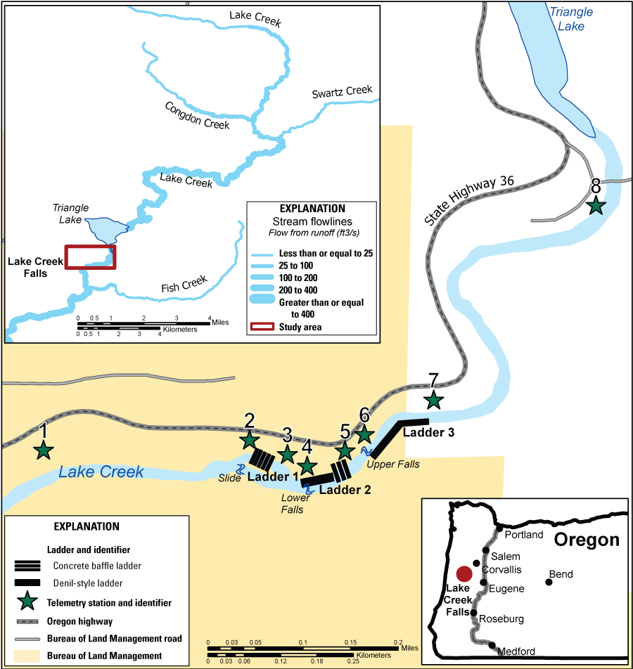
Upper Siuslaw River Basin, Oregon, including details of Lake Creek Falls, fish passage ladders, and the location of the telemetry receiver stations. The downstream-most natural barrier to upstream passage is a bedrock slide (shown as “Slide” on the map, see figure 2 for an image) followed by two vertical drops (shown as Lower and Upper Falls on the map). Constructed ladders to allow upstream passage of migrating coho salmon (Oncorhynchus kisutch) are indicated at each natural barrier (see figure 2 for images of each). Stream flowlines included in this figure are sourced from the National Hydrography Dataset.
Historically, passage of upstream migrating coho salmon was limited by Lake Creek Falls, a series of three natural barriers to upstream movement. Lake Creek Falls was formed about 10,300 years ago by a massive landslide, which dammed the stream and formed 256-acre Triangle Lake upstream (Lane, 1987). The resulting waterfalls are composed of two upstream vertical drops and a downstream bedrock slide which formed barriers to upstream passage of coho salmon (fig. 2). In 1989, the Bureau of Land Management (BLM) constructed fish ladders over each of these falls to allow upstream passage of coho salmon and other anadromous species (fig. 2; Buell and Associates, Inc., 1986).
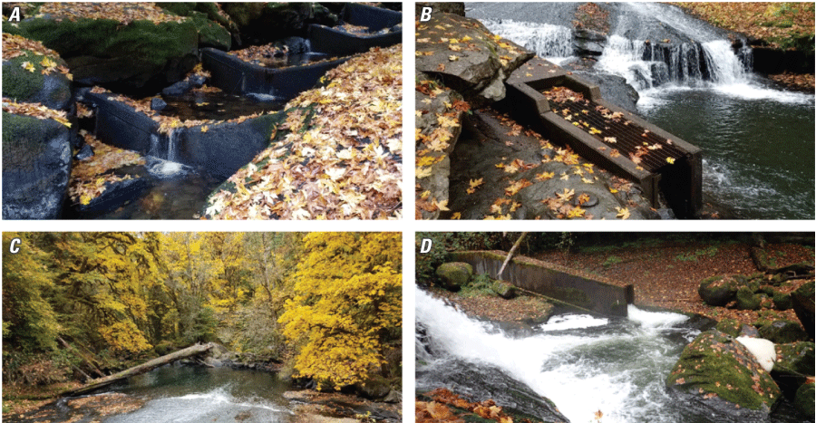
Natural passage barriers and fish ladders at Lake Creek Falls, Oregon (see fig. 1). (A) Concrete baffles acting as ladders in a constructed side channel that allows upstream passage of adult coho salmon (Oncorhynchus kisutch) past the downstream natural passage barrier during higher flows. (B) Middle falls at Lake Creek Falls, consisting of bedrock sheet flow and a vertical drop. Entry to the Denil-style fish ladder visible in foreground. (C) Downstream end of bedrock sheet flow (the slide) at the lower extent of Lake Creek Falls, with entrance to constructed side channel that allows passage visible on the right. (D) Vertical drop of upper falls at Lake Creek Falls, with entry to Denil-style fish ladder visible in background. Photographs by Reed B. Fischer, U.S. Geological Survey, October 2019.
The design of the three fish ladders included a semi-natural side channel downstream to allow passage over the lower falls, with two highly engineered Denil-style ladders (Fulton and others, 1953). Although adult coho salmon are known to cross these structures based on observations of adult and juvenile coho salmon upstream from the falls, passage efficiency at the falls is unknown. Generally, few direct assessments of the ability of salmonids to pass through Denil structures are available (Schmetterling and others, 2002; Roscoe and Hinch, 2010; Noonan and others, 2012), so little literature is available from which to base an assessment. Although it is possible to conduct a physical assessment of these structures based on hydrodynamic models and assumptions about the movement capacity of fish (for example, Khan, 2006), the most direct approach involves tracking upstream passage of individual fish.
In this study, we tracked movements of individually radio-tagged adult coho salmon as they approached Lake Creek Falls with the presumed motivation to move upstream into Triangle Lake and its tributaries. Our objectives were to (1) quantify the proportion of tagged fish known to have moved upstream over each of the individual fish passage structures, and (2) assess the potential influences of extrinsic (for example, streamflow) and intrinsic (for example, fish condition and size) factors on upstream passage, and (3) identify the final last known locations of tracked individuals. This information will provide a critical foundation for more formal evaluation of the role of upstream passage over Lake Creek Falls in production of coho salmon, which is listed as a threatened species under the U.S. Endangered Species Act (National Marine Fisheries Service, 2016).
Methods
Overview of Study Design
Design of this study was based on a meeting held on April 18, 2019, in Florence, Oregon, with a group of stakeholders concerned with actions to improve habitat and population status of coho salmon in Lake Creek, a major tributary of the Siuslaw River (fig. 1). The meeting was hosted and facilitated by the Confederated Tribes of the Coos, Lower Umpqua, and Siuslaw Indians, with Tribal staff in attendance, along with staff representing the Bureau of Land Management (BLM), National Marine Fisheries Service, Oregon Department of Fish and Wildlife, Siuslaw Watershed Council, and U.S. Geological Survey (USGS). At the meeting, stakeholders discussed fish passage over existing structures (fish ladders) installed by BLM and methods for monitoring fishway effectiveness for upstream passage of adult coho salmon. The overall management objectives identified were to (1) maximize the window of opportunity for upstream passage of adult coho salmon over Lake Creek Falls; and (2) identify cost-effective investments over short and long-term horizons (timeframes not specified) for maintenance, modification, or replacement of structures to improve passage. In the framework of structured decision making (Conroy and Peterson, 2013), the first objective can be considered a fundamental objective (what stakeholders want) and the second a means objective (the means to attain the fundamental objective). Once these objectives were identified, methods for evaluation were discussed, leading to the collective formulation of the study to meet management objectives Based on this discussion, stakeholders indicated that the preferred method of evaluating passage was tracking individual adult salmon using radio telemetry during their upstream migration passage over the three fish ladders in autumn. We initiated this work with a strong participatory element to ensure that collective objectives associated with this study were clear and based on a consensus among stakeholders responsible for managing coho salmon in the study system.
In addition to the basic question of upstream passage, stakeholders also expressed interest in the potential influences of stream discharge (river flows), time of year (for example, stream temperature, fish motivation), responses to each ladder (for example, physical features of each structure), and specific fish characteristics (for example, length, sex, stage of maturation). Because these factors were often naturally confounded and sample sizes with telemetry were limited (for example, by available funding and permitting limitations), we did not expect results of this study to resolve each of these influences. These limitations aside, we included a descriptive assessment of river flows, which are believed to limit upstream passage, particularly when flows are low or exceptionally high. In addition to passage efficiency (number of fish that successfully passed over a barrier divided by the number that approached it), we also documented duration for each upstream crossing at each ladder (for example, number of days to cross), and downstream passage owing to fallback (involuntary or unintentional crossing downstream) or emigration (directed downstream movement motivated by a proximal stimulus). We also mapped the final location of every fish to determine whether they used tributaries that could serve as spawning locations upstream and downstream from the falls. We did not assess pre-spawning survival in this study.
River Flows
Stakeholders identified river flows as a major factor of interest with respect to upstream passage of adult coho salmon over Lake Creek Falls. We selected two USGS streamgages near Lake Creek Falls to represent river flows in the study area—streamgages USGS 14307620 on the Siuslaw River near Mapleton, Oregon, and USGS 14306340 on East Fork Lobster Creek Near Alsea, Oregon. Although the latter streamgage is not within the Siuslaw River Basin, it is close to the study site and represents a basin area that is more comparable to Lake Creek. River flows in the Oregon Coast Range are directly and immediately impacted by rainfall events. Triangle Lake likely modifies the hydrographic response at Lake Creek Falls after upstream rain events; however, we assumed that nearby river flows reasonably approximated river flow conditions at Lake Creek Falls.
Radio Telemetry Receiving Systems
Gastrically implanted radio tags and telemetry were used to track adult coho salmon, a method that has been shown to be effective in other applications (for example, Liedtke and Wargo-Rub, 2012; Kock and others, 2019; Chapman and others, 2020; Liedtke and others, 2020). Radio telemetry antennas and data-logging receivers were installed throughout the study area. Antennas were either aerial Yagi-Uda or underwater stripped coaxial cable. Signal acquisition at each antenna was logged using either Lotek SRX_400-W16 receivers (Lotek Wireless, Inc., Newmarket, Ontario, Canada) or Orion receivers (Sigma Eight Inc., Aurora, Ontario, Canada). Receivers and 12-volt marine deep-cycle batteries were secured in locked, protective metal boxes with an informative pamphlet attached to the top that provided study information (fig. 3).
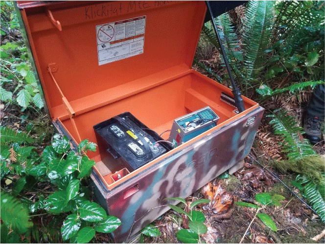
Radio telemetry data-logging receiver and 12-volt battery in metal box monitoring radio-tagged coho salmon (Oncorhynchus kisutch) in Lake Creek, Oregon. Photograph by Nicholas Scheidt, Bureau of Land Management, October 16, 2019.
Arrays to monitor fish movement were deployed at the lower and upper end of each ladder as well as downstream and upstream from the three ladders to measure passage and egress from the vicinity of Lake Creek Falls. Aerial arrays of single Yagi-Uda antennas were deployed 0.2 miles (mi) downstream from the lower ladder (station 1), directly downstream and upstream from the upper ladder (stations 6 and 7), and 0.25 mi upstream from the upper ladder (station 8; table 1). Four sites deployed downstream and upstream from the lower and middle ladders each consisted of two stripped coaxial cable antennas positioned underwater and monitored by an Orion receiver (stations 2–5, fig. 1). Antennas were placed in areas where overlap between sites was minimal, and the signal was attenuated to further reduce overlapping detections. All receiver systems with multiple antennas were amplified with a 12-volt, 25-decibel-milliwatt (dBm) signal amplifier as soon as the coaxial cable was either out of the water, or if it was located 20 feet (ft) or more from an aerial Yagi-Uda antenna. Single antennas were connected directly to the receiver if the coaxial run was shorter than about 30 ft; otherwise, they also were amplified. Antenna runs were amplified to compensate for any (1) signal loss through the coaxial cable, (2) combiners used to combine multiple antennas into one signal, or (3) splitters used to split a single signal into multiple receivers. Fixed-attenuators then were added at the receiver to adjust the signal down to balance the system. A balanced antenna system resulted in a net gain or loss of 0-dBm of signal strength from the point of amplification to the receiver, regardless of how long the coaxial run was or how many combiners/splitters were used. Balancing was accomplished by inputting a known strength signal into the amplifier and adding attenuators at the receiver to reduce the signal down to the original strength.
Table 1.
Fish-monitoring locations, equipment type, and gain-setting to monitor radio-tagged adult coho salmon (Oncorhynchus kisutch) movement at Lake Creek, Oregon, 2019.[Receiver gain: N/A, not applicable]
Receiver sites were visited every 3–4 days throughout the study period for data download, maintenance, and troubleshooting. The 12-volt batteries were switched out on each visit and charged prior to the next visit.
Radio Transmitters
We used digitally encoded radio transmitters that operated at frequencies ranging from 166.320 to 166.700 megahertz. The radio transmitters used (Sigma Eight, Inc. model TX-PSC-I-450, weight 8.5 grams in air, 28-centimeter [cm] antenna, 46.0-millimeter [mm] length × 12.0-mm width) emitted a radio signal every 4.5, 4,7, 4.9, 5.1, or 5.3 seconds. The expected battery life was 2,501 days. Each tag was programmed to produce the radio signal at a single interval and the intervals were varied for the tags used on each tagging day to reduce the chance of radio signal collisions if multiple tags were in the same area for an extended time. Tags were fitted with a band (about 1.5 mm) of surgical tubing to increase roughness to reduce the likelihood of transmitter regurgitation (Keefer and others, 2004).
Fish Tagging
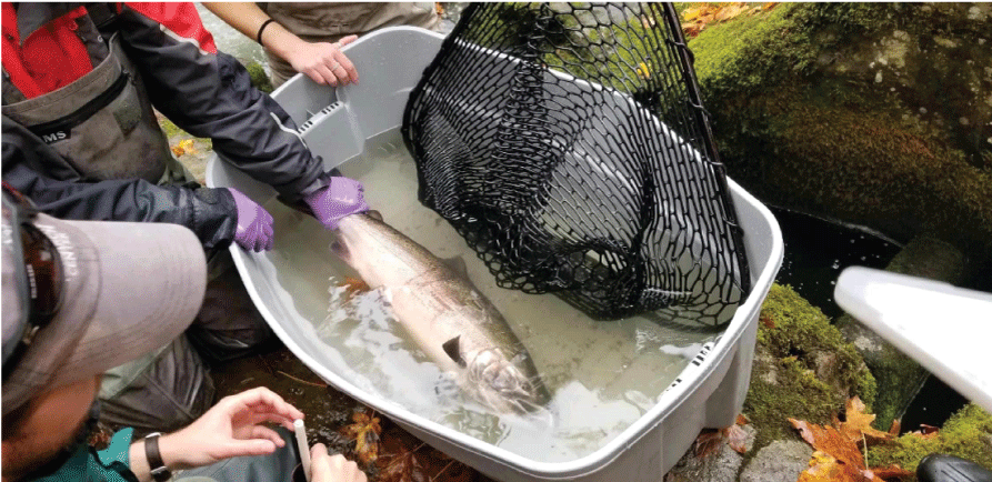
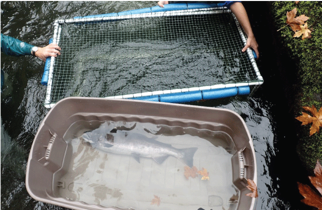
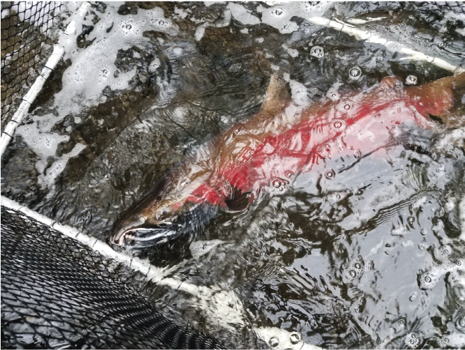
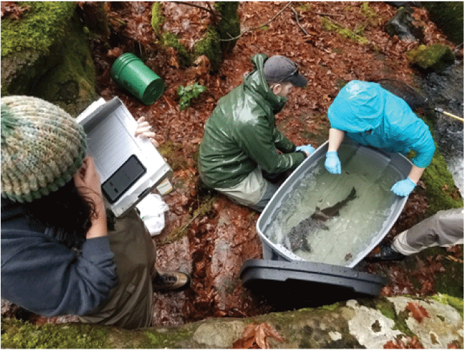
Adult coho salmon migrating upstream from the main-stem Siuslaw River and into Lake Creek were captured and tagged as they moved through the first two ladder structures on Lake Creek Falls. All fish were captured using large rubber-meshed dip nets and immediately transferred to large plastic tubs for tagging (fig. 4) or if not immediately tagged, they were held in large (2-ft × 4-ft) mesh-sided enclosures within the river prior to tagging (figs. 5 and 6). Selection of fish for tagging was opportunistic and dependent on river flows sufficient to allow fish to enter the ladder structures. We tagged most fish and only rejected very small individuals, or those in obviously poor condition.
Anesthetized adult coho salmon (Oncorhynchus kisutch) at Lake Creek, Oregon. Fish is held in the plastic tub where tagging was performed. This fish was classified as “Bright” with respect to categories of maturation used herein. Photograph by Nicholas Scheidt, Bureau of Land Management, October 16, 2019.
Plastic tub of anesthetic and river water and live well cage used for recovering fish after anesthesia and gastric implantation of radio tags, Lake Creek, Oregon, December 2019. Photograph by Nicholas Scheidt, Bureau of Land Management, December 10, 2019.
Live well cage used for recovering fish after anesthesia and gastric implantation of radio tags, Lake Creek, Oregon, December 2019. This fish was classified as “Mature” with respect to categories of maturation used herein. Photograph by Reed B. Fischer, U.S. Geological Survey, December 16, 2019.
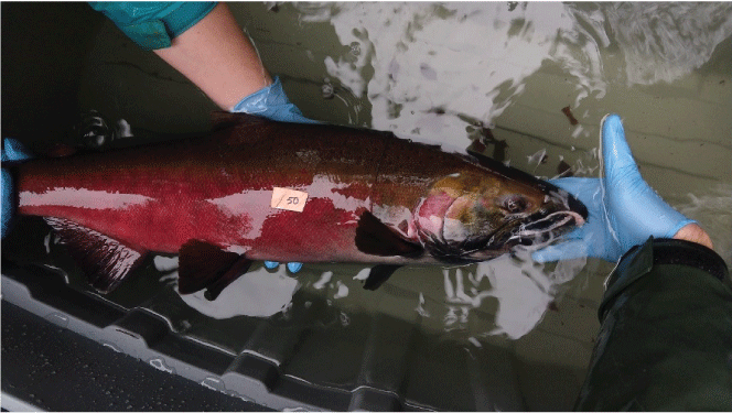
Tagging was initiated by placing fish into an anesthetic tank (figs. 4 and 5), and a timer was started to ensure that no individual was in the tank for longer than 5 minutes. All fish were tagged in 4 minutes or less. Fish were anesthetized 1–3 minutes in a concentration of 15–20 milligrams per liter (mg/L) of Aqui-S 20E (Aqua Tactics, Kirkland, Washington) in river water, prior to tagging. A cover was immediately placed over the tank to prevent fish escape during initial stages of anesthesia. Prior to insertion, transmitters were disinfected with chlorhexidine diacetate solution (diluted to 30 mg/L) for at least 15 minutes and rinsed in distilled water, then placed in glycerin to help ease the friction of tag insertion. Sex, condition, fork length in centimeters, and maturity were all recorded for each captured specimen. A ratio of tag weight to fish weight was calculated by dividing the tag weight in air with an estimated fish weight using fork length-weight relationships described by Schneider and others (2000). The maturity category (Theresa Liedtke, U.S. Geological Survey, personal commun.) was defined as B, Bright (silvery coloration, with little evidence of external damage such as injuries and deteriorated fin margins; see fig. 4); M, Mature (spawning pigmentation, with minor external injuries or erosion of fin margins; see fig. 6); and R, Ripe (major external injuries or erosion of fin margins, including fish that appeared to have spawned). These categories were unavoidably subjective, but there were clear and obvious differences between what we called bright individuals compared to fish in more advanced stages of maturation and spawning condition (see figs. 4–7).
Each coho salmon (Oncorhynchus kisutch) photographed with a number identification plate during anesthesia. This fish was classified as “Mature” with respect to categories of maturation used herein. Photograph by Victoria Jones, Bureau of Land Management, October 16, 2019.
Tag implantation followed methods described in Keefer and others (2004). Tagging involved insertion of the tag antenna into a 7-inch long and ¼-inch wide polyvinyl chloride (PVC) pipe. The anesthetized fish was held by an assistant as the tagger rotated the fish dorsal-ventrally, using one hand to open the mouth slightly and the other to carefully insert the PVC pipe into the stomach to avoid rupture of the stomach lining (fig. 8). Once the tagger determined the correct position of the tag, the PVC guide tube was carefully removed, and the antenna was bent to run parallel to the axis of the tagged fish’s body. Bending the antenna reduced the likelihood that it would interfere with the natural movement and navigation of the fish.
Bureau of Land Management and U.S. Geological Survey staff placing salmon in an anesthetic bath prior to radio tagging. Photograph by Nicholas Scheidt, Bureau of Land Management, October 16, 2019.
Fish Movements
Movements of radio-tagged fish were tracked with stationary receivers and mobile tracking. Each of the eight stationary receivers behaved as gates through which each tagged fish passed, moving either upstream or downstream at Lake Creek Falls (fig. 1). In addition to tracking fish at these stationary locations, we used opportunistic mobile tracking. Mobile tracking was intended to confirm what the stationary receivers detected and to extend the reach of tracking outside the vicinity of Lake Creek Falls, including tracking fish to tributaries potentially used for spawning. For mobile tracking, a single Yagi-Uda and a Lotek SRX_400-W16 receiver was used near rivers and spawning tributaries to locate tagged fish. The mobile receivers used in this study were capable of scanning one frequency at a time and multiple trackers were deployed multiple times each week to confirm results among trackers. Fish locations were recorded and later entered into a database to confirm the exact position of each tag. Fish were tracked immediately after the first release on October 21, 2019, through February 20, 2020.
Data Analysis
River Flow
Mean daily river flows in available years from 1991 to 2022 were downloaded (U.S. Geological Survey, 2019a, 2019b) and plotted from September 1, 2019, to February 28, 2020. Daily river flows during the September–February period in previous years also were plotted for reference.
Tagged Fish Characteristics
For each fish and tagging event, we summarized sex, fork length (in centimeters), maturity category, and relative tag weights. Relative tag weights were derived by estimating weights of fish based on a length-weight regression (Schneider and others, 2000) and dividing the tag weight by the weight of the individual tagged.
Fish Movements
Most of our efforts were focused on tracking movements of fish upstream or downstream across the three ladders at Lake Creek Falls. Data downloaded from fixed receivers in the Lake Creek Falls area were converted from text files to comma-separated value (csv) files. These files were combined into one or two csv files per receiver, depending on file size, and sorted chronologically by each tag code. Noise codes (tag codes not used in this study) and data prior to release were removed from the data files. Each fish record was reviewed separately by two trained technicians to determine arrival and departure at each receiver detection area upstream and downstream from the released location. If a gap in detections was determined for a fish moving upstream, for example, it was interpreted that the fish was somewhere between receivers and would be confirmed with mobile tracking equipment. The date and time of arrival and departure for each fish were recorded in a spreadsheet. A fish was determined to have passed a ladder if it was confirmed not only by the stationary receivers at the ladder, but also by the next upstream receiver. This redundancy helped reduce false detections that cause inaccurate passage rates for each ladder. This entire data entry and interpretation process was completed twice. Any discrepancies were reconciled in a final arrival and exit dataset. This process reduced human error and provided the most accurate passage rates for the three ladders. Additional mobile tracking allowed us to document entry into tributary streams potentially used for spawning. These locations are reported herein, but we did not confirm spawning activity. We were unable to rigorously track individual fish to determine their ultimate fates, but last known locations were reported.
Results
River Flows
A graph of river flows in 2019 relative to previous years at both streamgages indicated relatively low flows with delayed onset of higher flows until December 2019 compared to the 24- and 30-year periods of record available for USGS streamgages on the Siuslaw River and Lobster Creek, respectively (figs. 9 and 10).
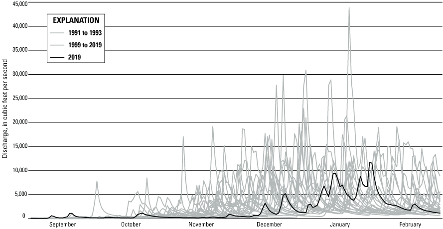
Mean daily flow in the Siuslaw River near Mapleton, Oregon (U.S. Geological Survey streamgage 14307620), over 24 years (1991–2019; data missing for 1994–98). The year of this study (2019) is indicated with a black line for reference.
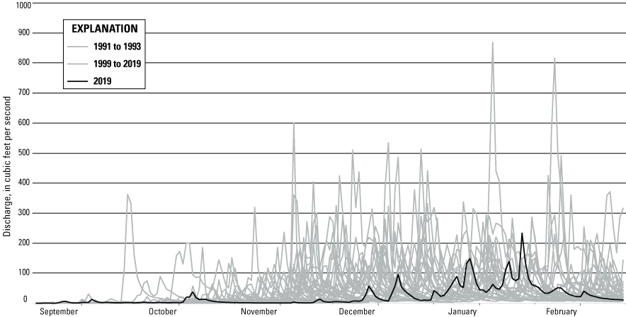
Mean daily flows in East Fork Lobster Creek near Alsea, Oregon (U.S. Geological Survey streamgage 14306340), over 30 years (1991–2019). The year of this study (2019) is indicated with a black line for reference.
Fish Tagging
Capture of fish followed peaks in river flow (figs. 9 and 10), with most fish tagged late in November and in December (table 2). We tagged and tracked a total of 87 naturally produced adult coho salmon, including 48 females and 39 males. A total of five tagging sessions occurred—one in October, two in November, and two in December 2019 (table 2). Median fork lengths of fish tagged were 69.1 and 70 cm, respectively, whereas the range of fork lengths was 54–82 cm (fig. 11). Using estimated fish weights, the tag-weight-to-fish-weight ratio (tag burden) ranged from 0.13 to 0.54 percent and the median was 0.22 percent. Fish matured throughout the season with a greater number of tagged fish observed in categories Bright and Mature in October and categories Mature and Ripe in December (table 2). No fish were observed to regurgitate tags, and zero mortalities occurred during capture, tagging, or release.
Table 2.
Number of radio-tagged coho salmon (Oncorhynchus kisutch) released, range of individual fork lengths, tag burden, maturity category, and number of fish released on each tagging date detected passing each ladder in Lake Creek, Oregon, 2019.[Date tagged: mm-dd-yyyy, month, day, year. Fork length: min, minimum; max, maximum; cm, centimeters. Tag burden: Tag-weight-to-fish-weight ratio (may be a range), calculated by dividing weight of tag by estimated fish weight. Maturity category: B, Bright; M, Mature; R; Ripe]
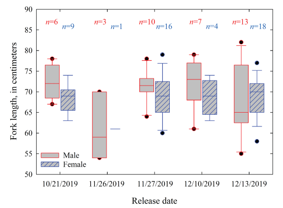
Boxplots showing fork lengths of radio-tagged adult coho salmon (Oncorhynchus kisutch) released in Lake Creek, Oregon, 2019. Numbers (n) above the boxes represent the number of fish released on that specific date. Box hinges are the 25th and 75th percentiles, the line bisecting the box is the median, whiskers are the 10th and 90th percentiles, and dots are the 5th and the 95th percentiles.
Fish Movements
The total number of fish passing over each ladder varied by tagging group (fish tagged on a specific date), with the percentage of tagged fish passing ladders decreasing over time (table 2, fig. 12). Of the 15 fish tagged in October, 93.3 percent passed the lower ladder within the first 2 days and 100 percent passed by December 15, 2019. Passage over the lower ladder was slower for the fish released in November and December. More than 60 percent of fish passed the lower ladder by December 7 for the November tagged group and by December 14 for the December tagged group. A total of 83.3 percent of November fish and 97.6 percent of December fish passed over the lower ladder and rates of passage between males and females were similar. All the fish tagged in October eventually passed over the middle ladder and 80.0 percent did so by October 30, with the remaining fish passing at a rate of about one fish per week. A total of 50.0 percent of tagged fish released in November passed over the middle ladder. These fish were composed of more than 50 percent Ripe fish. Of the November fish that passed over the middle ladder, 50.0 percent passed by December 10, and 100 percent within 23 days after tagging. A total of 23.8 percent of December fish passed over the middle ladder and did so within 12 days after tagging. The December group was composed of 50.0 percent mature fish and 45.2 percent ripe fish. The trends were similar with upper ladder passage. October fish steadily passed (> 93 percent), and the November (46.7 percent) and December (19.0 percent) groups passed within a few weeks of release.
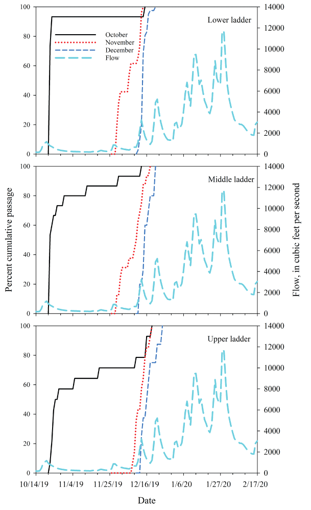
Cumulative percentage of passage by date for radio-tagged adult coho salmon (Oncorhynchus kisutch) that successfully passed upstream over each ladder (see table 2) and Siuslaw River flow in Lake Creek, Oregon, 2019–20. Solid, dotted, and thinner of the two dashed lines indicate the cumulative passage of coho salmon tagged in October, November, and December of 2019, respectively. Thicker of the two dashed lines indicate daily streamflow in the Siuslaw River (U.S. Geological Survey streamgage 14307620; units of measure on right y-axis).
Movement behaviors through Lake Creek and Lake Creek Falls varied throughout the study period. We considered whether fish moved upstream or downstream relative to their original tagging location (that is, detected at receivers upstream or downstream from an individual’s original tagging location), and locations of final detections for each fish. Nearly twice as many males moved only upstream compared to those who moved only downstream, whereas an equal number of females moved exclusively upstream or downstream (table 3). About 43 percent of both sexes stayed in a single location for a minimum of 5 days, predominantly from the October and November release groups when flows were lower (fig. 11). From 9 to 10 percent of coho salmon stayed in a single location for at least 5 days after the December tagging events. More than one-half of all fish in each November and December release group moved upstream and downstream during the study period, except for the males in the November 27 release group, 40 percent of which moved in both directions.
Table 3.
Number of male and female radio-tagged coho salmon (Oncorhynchus kisutch) detected crossing Lake Creek Falls and last location, Lake Creek, Oregon, 2019.[Fish can be enumerated in multiple Crossing Lake Creek Falls categories, but only once per fish in the last locations. Date tagged: mm-dd-yy, month, day, year. N tagged: Number of fish tagged]
Many of the radio-tagged coho salmon were last detected in a tributary downstream from Lake Creek Falls, and locations of final detections were similar between the sexes (table 3). By tag date, the predominant last known location for fish tagged in October was in upstream tributaries for males, whereas locations for females were mostly uncertain. Males and females tagged in November were widely distributed in the study area at the last known location. More than one-half of the fish tagged in December were last found in tributaries downstream from Lake Creek Falls (see Appendix 1, table 1.1 for details).
Discussion
Although the total number of fish tagged and tracked (87) was relatively small, with only 1 year of spawning migration observations (upstream migration during autumn and winter of 2019–20), we can draw several conclusions based on our findings. Relatively low stream discharges during the expected time of spawning migration likely influenced the rate of upstream passage (October–December; figs. 9 and 10). From October through late November, stream discharges were generally not high enough to allow fish to cross passage structures at Lake Creek Falls, and we were only able to capture, tag, and track 15 fish during one higher-flow event in October, with the remainder of fish tagged on or after 27 November 2020, as higher flows were more prevalent (table 2).
Fish that were captured, tagged, and tracked in October (table 2) showed fewer signs of advanced maturation (for example, silvery coloration, less development of secondary sexual characteristics), and were more likely to quickly pass over each of the three passage structures at Lake Creek Falls, relative to fish captured, tagged, and tracked later in November and December (fig. 12). Because the condition of fish (for example, stage of maturation and available energy reserves) and discharge are confounded in time, it is not possible to unequivocally attribute rates of passage over the structures at Lake Creek Falls to any single factor. Collectively, however, these influences may be important drivers of passage over Lake Creek Falls.
Of the 87 fish tracked, we observed 34 (39 percent) that crossed upstream over all three fish ladders at Lake Creek Falls at least once (not considering individuals that crossed downstream over the falls after crossing upstream), and of these fish, 44.1 percent (15 fish, 10 males and 5 females) were confirmed in suspected spawning tributaries of Lake Creek upstream from Triangle Lake. Field visits to these sites indicated the presence of spawning coho salmon, including some individuals with tags. Fish that crossed Lake Creek Falls and ultimately moved into downstream tributaries, or fish that did not cross the falls, were detected in a number of locations where spawning has been observed. Rates of upstream passage varied among the three ladders over Lake Creek Falls. Nearly all fish tagged in October crossed upstream over the three ladders, whereas by November and December, numbers of fish crossing upstream decreased substantially, particularly for the upper two ladders (table 2). Overall, most fish were observed to have crossed the lower ladder, whereas passage over the upstream two ladders was reduced later in the year.
Without a much longer-term study involving many more fish, it is difficult to draw firm conclusions regarding the overall influences of the passage structures on the likelihood of upstream passage by adult coho salmon. However, substantial numbers of fish clearly are capable of crossing upstream. Even in the absence of obvious potential barriers, migratory patterns of anadromous salmon often are complex, with fish moving into many different locations on their way to a final spawning destination (Keefer and Caudill 2014). Furthermore, the role of coho salmon produced upstream from Lake Creek Falls is uncertain relative to production of coho salmon in this watershed overall (for example, upstream and downstream from Lake Creek Falls). Some of the coho salmon that failed to cross upstream over Lake Creek Falls likely were produced from tributaries upstream but contributed to production downstream. Although Pacific salmon are noted for their propensity to home to their natal locations, they can disperse broadly when conditions dictate such as avoidance of unsuitable conditions or incomplete access during extended periods of low flows (Flitcroft and others, 2012). Given these questions, application of population models (for example, Tsuboi and others, 2013) may be useful to consider in evaluating how incomplete passage potentially influences coho salmon populations upstream and downstream, based on varying levels of passage over the three structures. To that end, this study provides an empirical foundation that could support future evaluation of this question.
References Cited
Chapman, J.M., Teffer, A.K., Bass, A.L., Hinch, S.G., Patterson, D.A., Miller, K.M., and Cooke, S.J., 2020, Handling, infectious agents and physiological condition influence survival and post-release behaviour in migratory adult coho salmon after experimental displacement: Conservation Physiology, v. 8, 24 p., accessed December 12, 2020, at https://academic.oup.com/conphys/article/8/1/coaa033/5838573?login=true.
Kock, T.J., Evans, S.D., Ekstrom, B.K., and Hansen, A.C., 2019, Adult sockeye salmon (Oncorhynchus nerka) behavior and movement from Roza Dam to Cle Elum Dam, Washington, 2018: U.S. Geological Survey Open-File Report 2019–1053, 8 p., accessed July 3, 2022, at https://doi.org/10.3133/ofr20191053.
Liedtke, T.L., Kock, T.J., Hansen, A.C., Ekstrom, B.K., and Tomka, R.G., 2020, Behavior and movement of adult winter steelhead (Oncorhynchus mykiss) in the upper Cowlitz River Basin, Washington, 2017–18: U.S. Geological Survey Open-File Report 2020–1054, 35 p., https://doi.org/10.3133/ofr20201054.
Liedtke, T.L., and Wargo-Rub, M.A., 2012, Techniques for telemetry transmitter attachment and evaluation of transmitter effects on fish performance, in Adams, N.A., Beeman, J.W., and Eiler, J.H., eds., Telemetry techniques—User guide for fisheries research: Bethesda, Maryland, American Fisheries Society, p. 45–87.
Schneider, J.C., Laarman, P.W., and Gowing, H., 2000, Length-weight relationships chap. 17 of Schneider, J.C. ed., Manual of fisheries survey methods II—With periodic updates: Ann Arbor, Michigan Department of Natural Resources, Fisheries Special Report 25, accessed December 21, 2020, at https://www2.dnr.state.mi.us/publications/pdfs/IFR/manual/SMII%20Chapter17.pdf.
Silva, A.T., Lucas, M.C., Castro‐Santos, T., Katopodis, C., Baumgartner, L.J., Thiem, J.D., Aarestrup, K., Pompeu, P.S., O’Brien, G.C., Braun, D.C., Burnett, N.J., Zhu, D.Z., Fjeldstad, H.-P., Forseth, T., Rajaratnam, N., Williams, J.G., and Cooke, S.J., 2018, The future of fish passage science, engineering, and practice: Fish and Fisheries, v. 19, no. 2, p. 340–362.
U.S. Geological Survey, 2019a, USGS 14307620 Siuslaw River near Mapleton, Oregon: U.S. Geological Survey National Water Information System database, accessed September 24, 2020, at https://doi.org/10.5066/F7P55KJN (site information directly accessible at https://waterdata.usgs.gov/or/nwis/uv?site_no=14307620).
U.S. Geological Survey, 2019b, USGS 14306340 East Fork Lobster Creek near Alsea, Oregon: U.S. Geological Survey National Water Information System database, accessed May 29, 2020, at https://doi.org/10.5066/F7P55KJN (site information directly accessible at https://waterdata.usgs.gov/or/nwis/uv/?site_no=14306340&PARAmeter_cd=00065,00060).
Appendix 1. Final Locations of Radio-Tagged Adult Coho Salmon (Oncorhynchus kisutch) Released in Lake Creek, Oregon, 2019–20
Table 1.1.
Final location of radio-tagged adult coho salmon (Oncorhynchus kisutch) released in Lake Creek, Oregon 2019–20.[Sex: F, Female; M, Male. Release location: Refers to location below ladders (lower, middle, or upper ladder). Release date: mm-dd-yyyy, month, day, year. Maturity: M, mature; B, bright; R, ripe; MR, mature and ripe. Final location: N/A, Not applicable]
Conversion Factors
Supplemental Information
Concentrations of chemical constituents in water are given in milligrams per liter (mg/L).
For information about the research in this report, contact
Director, Forest and Rangeland Ecosystem Science Center
777 NW 9th Street
Suite 400
Corvallis, OR 97330
https://www.usgs.gov/centers/forest-and-rangeland-ecosystem-science-center
Manuscript approved on September 15, 2022
Publishing support provided by the U.S. Geological Survey
Science Publishing Network, Tacoma Publishing Service Center
Disclaimers
Any use of trade, firm, or product names is for descriptive purposes only and does not imply endorsement by the U.S. Government.
Although this information product, for the most part, is in the public domain, it also may contain copyrighted materials as noted in the text. Permission to reproduce copyrighted items must be secured from the copyright owner.
Suggested Citation
Fischer, R.B., Dunham, J., Scheidt, N., Hansen, A.C., and Heaston, E.D., 2022, Passage of adult coho salmon (Oncorhynchus kisutch) over Lake Creek Falls, Oregon, 2019: U.S. Geological Survey Open-File Report 2022–1083, 19 p., https://doi.org/10.3133/ofr20221083.
ISSN: 2331-1258 (online)
Study Area
| Publication type | Report |
|---|---|
| Publication Subtype | USGS Numbered Series |
| Title | Passage of adult coho salmon (Oncorhynchus kisutch) over Lake Creek Falls, Oregon, 2019 |
| Series title | Open-File Report |
| Series number | 2022-1083 |
| DOI | 10.3133/ofr20221083 |
| Publication Date | November 04, 2022 |
| Year Published | 2022 |
| Language | English |
| Publisher | U.S. Geological Survey |
| Publisher location | Reston, VA |
| Contributing office(s) | Forest and Rangeland Ecosystem Science Center, Western Fisheries Research Center |
| Description | vii, 19 p. |
| Country | United States |
| State | Oregon |
| Other Geospatial | Lake Creek Falls |
| Online Only (Y/N) | Y |