

Geospatial Standard Operating Procedures of the Chesapeake Bay Program
Links
- Document: Report (1.08 MB pdf) , HTML , XML
- Download citation as: RIS | Dublin Core
Introduction
Purpose
The Chesapeake Bay Program (CBP) has operated a geographic information system (GIS) program since the early 1990s to address the established and growing need for and use of geospatial data, maps, and analysis within the CBP Partnership. This report is intended to detail the standard operating procedures of the CBP GIS program and address the quality assurance, quality control, and other technical activities that CBP will implement to ensure the commitment of the CBP GIS Team to performance standards (U.S. Environmental Protection Agency, 2003). The report is intended as an update to the 2011 Quality Assurance Project Plan (QAPP). For specialized tasks or analytical projects beyond the scope of this QAPP, a separate specialized QAPP with details on quality control, assurance procedures, and the geospatial methods associated with all aspects of the project may be required.
GIS Program Organization
The CBP GIS Team is composed of a GIS Team Leader, a Research Geographer who leads the Land Data Team, and seven Geographers/Geospatial Analysts. The GIS Team Leader is employed by the U.S. Geological Survey (USGS). The GIS Team Leader, Research Geographer, and Geospatial Analysts work under cooperative interagency agreements between the U.S. Environmental Protection Agency, USGS, and the University of Maryland Center for Environmental Science (UMCES). The team is primarily responsible for analyzing, mapping, and modeling geospatial data. Other than land cover data, the source of the geospatial data is almost exclusively from other organizations.
Other individuals responsible for implementing the geospatial QAPP include the U.S. Environmental Protection Agency (EPA) Data Center Manager and Deputy Data Center Manager, who provide guidance and oversight for Data Center projects (including GIS), the quality assurance (QA) Officer, and the Branch Chief of the Science, Analysis, and Implementation Branch. The organization of the GIS Team and its relationship to the Chesapeake Bay Program Office (CBPO) Data Center is shown in figure 1.
In addition, the GIS Team routinely coordinates and collaborates with geospatial leads in national and regional EPA and USGS offices, academic institutions, government contractors, and nongovernmental organizations that support Chesapeake Bay initiatives. At times, this broader geospatial community (fig. 2) develops products and projects in collaboration with the GIS Team and may also be subject to this QAPP on such projects.
Finally, the intended users of the geospatial products are not included in the organizational charts because of their high numbers. Users of geospatial analyses include environmental management agencies in the Bay watershed jurisdictions (Pennsylvania, Maryland, Virginia, West Virginia, New York, Delaware, and Washington, D.C.), members and participants of the Chesapeake Bay Program Goal Implementation Teams (GITs) and Workgroups, Federal agencies, state and Federal contractors, academic researchers, nonprofit environmental organizations, and the press.
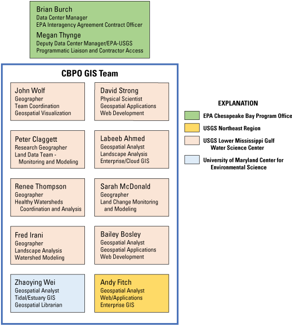
The Chesapeake Bay Program (CBP) geographic information system (GIS) Team and Data Center leadership organization chart. CBPO, Chesapeake Bay Program Office; EPA, U.S. Environmental Protection Agency; IAG, interagency agreement; GIS, geographic information system; NE, northeast; USGS, U.S. Geological Survey; LMG, Lower Mississippi-Gulf; UMCES, University of Maryland Center for Environmental Science.
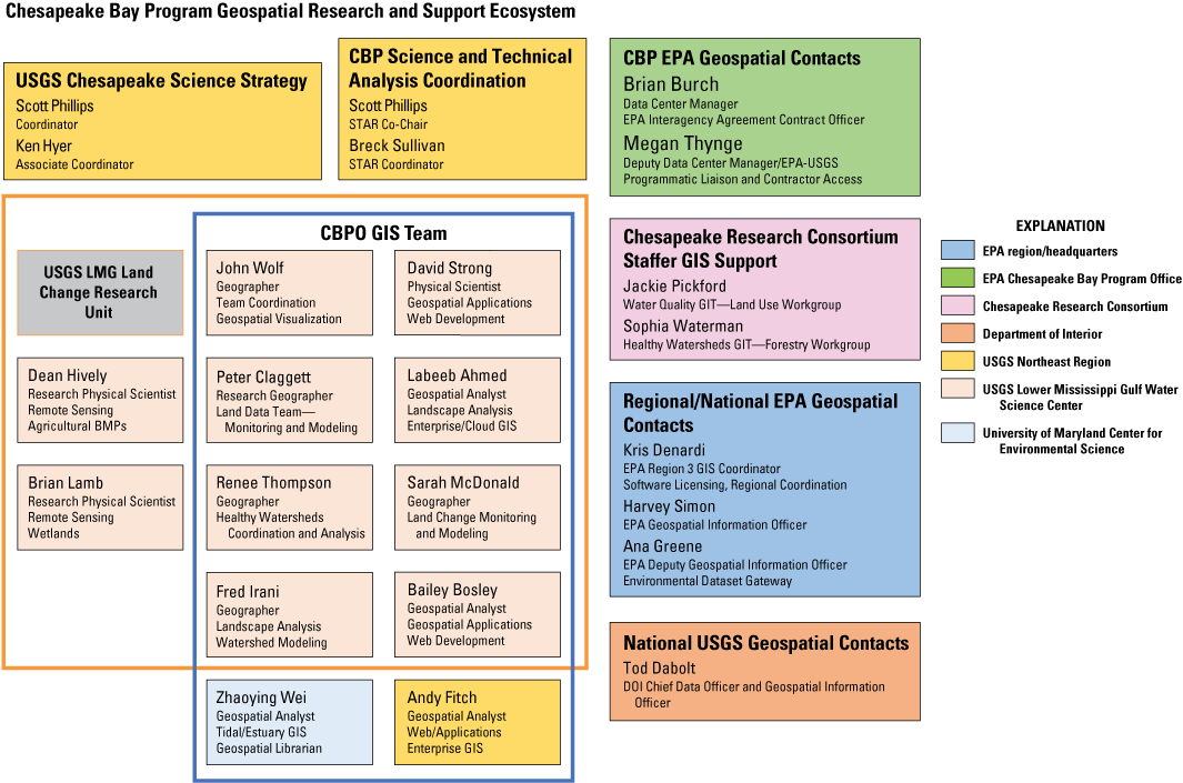
Chesapeake Bay Program geospatial research and support ecosystem chart. USGS, U.S. Geological Survey; CBP, Chesapeake Bay Program; STAR, Scientific, Technical Assessment, and Reporting Team; EPA, U.S. Environmental Protection Agency; IAG, interagency agreement; GIS, geographic information system; NE, northeast; LMG, Lower Mississippi-Gulf; GIT, Goal Implementation Team; DOI, Department of Interior; UMCES, University of Maryland Center for Environmental Science; CBPO, Chesapeake Bay Program Office; Hdqrt, headquarters; BMP, best management practice.
Problem Definition/Background
Goal
The GIS Team provides geospatial research and support to the CBP Partnership, including the provision of effective and accurate geospatial data, analyses, web applications, and maps. These services are primarily conducted to address the commitments outlined in the Chesapeake Bay Watershed Agreement (CBWA), Chesapeake Bay total maximum daily load (TMDL) for nitrogen, phosphorus and sediment, USGS Chesapeake Science Priorities, and needs identified by Scientific, Technical Assessment, and Reporting (STAR) to support the Strategy Review System (SRS).
Specifically, the GIS Team is charged with the following activities:
-
• Geographic analysis—Conduct integrated, multimedia analyses of geographical information used in regional land and watershed planning and modeling, and targeting nutrient, sediment, and chemical contaminant reduction and prevention programs in an optimal manner.
-
• Spatial data development—Coordinate with CBPO data managers, GIT leaders, and STAR members on the development of spatial databases needed to support CBP management and partner conservation and restoration efforts.
-
• Spatial data access—Develop the technical design and implementation of distributed, networked, spatial databases necessary for ensuring that the CBP partners and stakeholders have efficient, direct internet access to the environmental spatial data and information required to achieve the goals of the aforementioned agreements.
-
• Geospatial application development—In cooperation with the CBPO Data Center, develop programming solutions for integrating and automating spatial data analyses and associated results.
-
• Land change modeling—In cooperation with the CBP Land Use Workgroup and Healthy Watersheds Goal Implementation Team, develop, refine, and maintain the Chesapeake Bay Land-Change Model to support regional vulnerability and resource assessments and to inform land conservation and land-use planning decisions.
-
• Web-based GIS and data visualization applications—In collaboration with STAR, GITs, Workgroups, and the CBP Creative Team, develop, implement, and maintain internet-based GIS, mapping, and data visualization applications.
-
• Indicator development—In cooperation with the CBP Creative Team, develop multiscale geographic indicators that encompass environmental quality, implementation actions, and other related restoration and protection data and information.
-
• Technical GIS support—Provide expert GIS technical support to CBP partners and CBPO staff on the use of GIS to address Chesapeake Bay watershed conservation and restoration efforts.
-
• Grant and project review—Review grants and project deliverables for adherence to Chesapeake Bay Program guidance for GIS data management and related procedures.
GIS activities undertaken at the CBPO follow the directives outlined in the National Geospatial Data Policy (NGDP). The NGDP establishes the principles, responsibilities, and requirements for collecting and managing geospatial data used by Federal environmental programs and projects within the jurisdiction of the EPA. This policy also establishes the requirement of collecting and managing geospatial metadata that describes the EPA’s geospatial assets to underscore the agency’s commitment to data sharing, promoting secondary data use, and supporting the National Spatial Data Infrastructure.
The NGDP addresses the geospatial data represented by points, lines, polygons, and rasters. Additionally, it encompasses original and interpreted geospatial data derived through remote sensing, including but not limited to images and raster datasets, aerial photographs, and other forms of geospatial data or datasets in both digitized and nondigitized forms. The NGDP addresses geospatial data operations in the context of data life cycle phases, consisting of (1) planning, (2) collection and acquisition, (3) processing and documentation, (4) storage and access, and (5) maintenance and retirement. It applies to all EPA organizations, grantees, agents working on behalf of the EPA, Tribes, localities and partner states of the EPA that design, develop directly or indirectly, compile, operate, or maintain EPA information collections developed for environmental program support.
Objectives
-
• Support the goals of the CBWA through geospatial analysis and science.
-
• Develop and maintain authoritative CBP geospatial datasets. (Note: authoritative datasets are datasets created and maintained by CBP for which only CBP has the authority to determine the geometry and attributes of those data. In other words, CBP is the authoritative source of these data.)
-
• Construct and maintain a current geospatial data library for cartography and spatial analyses.
-
• Provide analytical and cartographic support for CBP’s partners.
-
• Provide analytical and cartographic support for presentations, publications, and meetings.
-
• Develop and maintain geospatial data, maps, applications, and data visualizations on CBP’s suite of websites.
-
• Facilitate distribution of geospatial data and tools for the CBP.
The GIS Team develops products for multiple audiences in the CBP Partnership. Examples of the types of products developed and used, and access to these products through the Open Data portal is illustrated in figure 3.
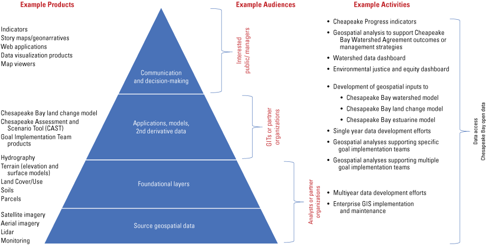
Hierarchy of geospatial data and data products used and produced by the Chesapeake Bay Program (CBP) geographic information system (GIS) Team. GIT, Goal Implementation Team; lidar, light detection and ranging.
Projects and Tasks
CBP’s GIS program serves the needs of the CBP GITs and Workgroups. The GIS Team is responsible for the following tasks:
-
1. Establish and maintain the CBP authoritative geospatial datasets for
-
A. Chesapeake Bay Monitoring Stations and Segments
-
B. Chesapeake Bay Modeling Segments
-
C. Protected Lands
-
D. Public Access Sites
-
E. Land Surface Data
-
F. Hydographic data
-
G. Other datasets as determined by the GIS and Land Data teams
-
-
2. Develop and maintain
-
3. Provide analytical and cartographic support for geospatial investigations, both internal and external
-
4. Develop and maintain
-
5. Manage CBP’s AGOL account
-
6. Manage geospatial data for Chesapeake Progress and other CBP websites
-
7. Coordinate operations with the CBP Data Center Manager and Deputy Data Center Manager
-
8. Participate in CBPO’s information technology (IT) Data Center activities
-
9. Participate in EPA and USGS geospatial and data visualization communities
This CBP GIS Program QAPP does not address specialized spatial analyses undertaken by CBP Partnership collaborators. These projects are documented in individual QAPPs associated with the specific projects or agreements. As jurisdictions are, in part, funded by the CBP through grants and cooperative agreements, they are subject to QA requirements as established in the “Chesapeake Bay Program Quality Assurance Guidelines and Requirements” section of the CBP Grant and Cooperative Agreement Guidance (U.S. Environmental Protection Agency, 2022). This section is relevant to projects involving the collection of environmental data.
The CBP Quality Assurance Program ensures that projects include sufficient upfront planning for the development of well-defined project goals and data quality objectives. These objectives need to be supported by the implementation of sampling design, collection, and analysis protocols such that the resultant data completely and accurately addresses the project’s goals. In order for the data to be useful to efforts to restore and protect the Chesapeake Bay, they must be of known and documented quality, having sufficient supporting documentation such that subsequent data users can evaluate if the data meets their needs. Additionally, data submission requirements for all grant or cooperative agreement funding are documented in the section “Chesapeake Bay Program Guidance and Policies for Data, Information and document Deliverables Submission” of the CBP Grant and Cooperative Agreement Guidance (U.S. Environmental Protection Agency, 2022).
Project Prioritization
GIS projects undertaken by the CBP GIS Team vary in complexity and the associated level of effort required to complete the project. The portfolio of the most complex projects (greatest level of effort) undertaken by the CBP GIS Team is planned for on an annual basis and is based on the relevance to the goals and outcomes of the CBWA. Recurrent or long-term projects are based on activities identified in (1) annual scopes-of-work between the EPA and USGS Lower Mississippi-Gulf and Virginia and West Virginia Water Science Centers, (2) the USGS Multi-Year Work Plan for Chesapeake Bay Studies, and (3) science needs identified through the STAR SRS planning process.
Shorter term, medium complexity projects are considered on a time-available basis and are based on the following criteria associated with CBP business processes, with projects meeting multiple criteria given greater priority:
-
• Does the project support one or more goals and outcomes of the CBWA?
-
• Is the project in support of the Chesapeake Bay TMDL, including Watershed Implementation Plans?
-
• Is the project multijurisdictional/multistate in geographic scope?
-
• Does the project support a Chesapeake Bay Data Center priority?
-
• Does the project support multiple GITs or Workgroups?
-
• Does the project support a CBP indicator or communication need?
Minimum complexity projects are typically completed in less than a day. These may include preparing a single map or graphic for a collaborator, generating simple geospatial statistics for a dataset, or developing metadata for an ArcGIS online map service.
Coordination
The GIS Team Leader coordinates GIS support activities within the CBPO Data Center with the EPA Data Center manager and Deputy Data Center manager. In addition, the GIS and Land Data teams coordinate with a variety of internal and external CBP and related committees and workgroups including, but not limited to the following:
STAR
The GIS team leader serves as a member of STAR and participates in the planning and review of CBP initiatives requiring geospatial support. This includes coordination with the Modeling workgroup, Nontidal Network team, Status and Trends workgroup, and other STAR workgroups as necessary.
Land Use Workgroup
The Land Data Team Leader coordinates the activities of the CBP Land Use Workgroup. This includes the identification of geospatial data needs and plans to address those needs.
Healthy Watersheds Goal Implementation Team (GIT)
The Healthy Watersheds GIT is coordinated by a Geographer on the USGS Team, who identifies opportunities to leverage geospatial technologies and analyses to support the identification and protection of healthy watersheds in the Chesapeake Bay Basin. This includes analyses required to identify vulnerabilities associated with climate change and population growth and development.
USGS Science Team
Members of the GIS and Land Data Teams serve in leadership roles in the USGS Science Strategy, including coordinating Theme 3: Characterize land use and change to assess the vulnerability and resiliency of vital lands and healthy watersheds and parts of Theme 4: Enhanced data and information sharing. The GIS and Land Data Teams contribute to multiple research elements contained in the Chesapeake Studies Multi-Year Work Plan and collaborate with scientists working on all four science themes (Hyer and Phillips, 2021).
Chesapeake Conservation Partnership
The GIS Team coordinates with the Chesapeake Conservation Partnership to assist with the development of core datasets that support land conservation objectives in the region. This includes the identification of important farmlands, forest lands, water-quality areas, habitats, cultural lands, and lands important for recreation or public access.
Chesapeake Conservancy
The GIS and Land Data Teams coordinate with the EPA contract administrator and serve as technical leads on the multiyear EPA geospatial agreement for geospatial support. The Land Data and GIS Teams serve as the technical leads for the land use/land cover, hydrology mapping, and the geospatial and web mapping support activities of the agreement.
Quality Objective and Criteria
The work completed by the GIS Team follows the guidelines set forth by the Chesapeake Bay Program Office Grant and Cooperative Agreement Guidance (U.S. Environmental Protection Agency, 2022), the National Geospatial Data Policy (U.S. Environmental Protection Agency, 2008), and the Content Standard for Digital Geospatial Metadata (Federal Geographic Data Committee, 1998). The objectives of quality assurance and quality control are
-
1. Ensure that CBP projects and products are high-quality and credible data that can be confidently used by staff, CBP Partnership, and the public.
-
2. Design, document, and implement standard quality control and assurance procedures that minimize or eliminate errors.
Quality assurance and control procedures pertain to the acquisition, creation, editing, and geoprocessing of geospatial data and the construction of maps for any purpose. Preferred source data include Federal (for example, National Hydrography Dataset, USGS SPARROW model) and state agency authoritative datasets.
The Federal Geographic Data Committee has identified six components of data quality (Federal Geographic Data Committee, 1998) that are applied to all geospatial data generated, manipulated, or acquired by CBP:
-
• Accuracy—positional
-
• Accuracy—attribute
-
• Completeness
-
• Logical consistency
-
• Precision
-
• Lineage
In addition to the six components above, all geospatial data generated and acquired are reviewed for
Training
The GIS Team members are required to have extensive experience and knowledge of geospatial mapping and analysis techniques. This collective experience is the first step in assuring quality for products generated by the Team. Team members regularly participate in professional development and continuing education opportunities to keep abreast of the latest technology and software capabilities. Opportunities for both training and certification are available at
-
• Esri (www.esri.com)
-
• GIS Certification Institute (www.GISCI.org)
-
• Online or in-person institution of higher education
Geospatial Skills
The collective skills and software proficiencies typically expected of GIS and Land Data Team members are listed in table 1, although specific positions vary in terms of duties and job assignments. These skills and proficiencies are associated with the use of proprietary and (or) open-source GIS software, programming languages, database software, web-based programming, graphic design, and data visualization software.
Table 1.
Geospatial skills expected of the geographic information system (GIS) Team.[GIS, geographic information system; QGIS, Quantum GIS; GDAL, Geospatial Data Abstraction Library; OGR, Open GIS Simple Features Library; 3D, three dimensional; AGOL, ArcGIS Online; CBP, Chesapeake Bay Program; SQL, structured query language; API, Application Programming Interface; REST, Representational State Transfer; SOAP, Simple Object Access Protocol; FGDC, Federal Geographic Data Committee; GPS, Global Positioning System]
Documents and Records
The following documents or documentation are developed and maintained by CBP:
-
1. CBP GIS program standards
-
2. Federal Geographic Data Committee (FGDC)/International Standards Organization (ISO) metadata for all CBP authoritative datasets
-
3. Existing documentation for secondary data sources if data are made accessible by CBP through the Open Data portal.
Metadata
The Chesapeake Bay Program adopted the FGDC-STD-001-1998 Content Standard for Digital Geospatial Metadata as the standard to follow when documenting CBP geospatial datasets. Subsequent to the adoption of the FGDC standards, the ISO developed ISO 19115: Geographic information—Metadata “to harmonize FGDC standards with other formal metadata standards.” Authoritative datasets published and distributed by CBP shall conform to these standards.
Authoritative Data
All authoritative datasets generated by CBP will comply with the CBP GIS program standards. In addition to dataset metadata, all CBP authoritative elements published on ArcGIS Online (Chesapeake Geoplatform) require summary metadata as detailed by the CBP GIS Open Data protocols.
Secondary Data
Data obtained from secondary sources will have existing metadata that will not be altered. This metadata will be maintained in the GIS folders with the original source data.
Operational Data
A majority of the operational datasets will not have updated metadata owing to the temporary nature of the data, interim purpose, or the secondary source for a majority of these data. Examples include the creation of new datasets for maps such as the selection of Chesapeake Bay watershed polygons from the National Hydrography dataset or extraction of NLCD land use land cover for a particular county. Both newly created datasets in the example have existing metadata from the authoritative source agency, are not distributed by CBP, and are processed only for cartographic effects required to develop the map.
AGOL Metadata
The CBP GIS Program provides guidance on metadata requirements for data, services, maps, and documents accessible through the CBP AGOL Open Data Portal. CBP will provide all metadata required. Metadata is limited by Esri to the following elements:
Metadata Keywords and Tags
CBP products will include the appropriate metadata keywords and tags prior to publishing online or distribution. The tags will be selected from a list created by CBP to standardize the naming conventions. The list is currently under development as products are still being identified. At a minimum, all maps, datasets, and distributed items will include the following metadata tags/keywords:
Data Generation and Acquisition
The CBP does not collect field measurements for spatial data generation. The GIS program is primarily responsible for maintaining CBP’s authoritative datasets, providing cartographic and spatial analytical products to CBPO staff and partners, as well as CBP outreach publications, presentations, and websites. This requires the development and maintenance of CBP’s authoritative data, and the acquisition and geoprocessing of secondary data. Secondary use of data is the use of environmental and socioeconomic data collected for other purposes or from other sources.
Data Generation
This section will address data generation of the authoritative datasets developed or maintained by the CBP GIS Team. To maintain consistent edge-matching for boundaries and spatial analyses of the authoritative CBP datasets, the spatial extent of Chesapeake Bay watershed data products will, where applicable, default to
-
• the Chesapeake Bay watershed boundary as defined by the National Watershed Boundary Dataset,
-
• the boundary of counties that intersect the Chesapeake Bay watershed boundary as defined by U.S. Census Bureau data products, or
-
• the boundary of states that intersect the Chesapeake Bay watershed boundary as defined by U.S. Census Bureau data products.
In addition to authoritative spatial datasets, CBP generates spatial data to represent progress in tracking goals and outcomes of the CBWA, as portrayed on the Chesapeake Progress website (www.ChesapeakeProgress.com). Examples include
-
• point locations of certified sustainable schools in the Chesapeake Bay watershed,
-
• line segments representing streams opened to migratory fish species as a result of fish passage projects, and
-
• polygon boundaries of Chesapeake Bay segments impaired by toxic contaminants.
For these data, the spatial accuracy of the geospatial data is the responsibility of the source providing the coordinates. The CBP reviews the geospatial data for location integrity in the general vicinity, but CBP does not assess the accuracy of the point, polyline, polygons, or raster data provided by partners when CBP is providing GIS support to them.
Data Acquisition
A majority of CBP’s GIS projects will use authoritative spatial data from partner agencies, which is referred to as “secondary data.” CBP geospatial datasets are sometimes composed of collected datasets from jurisdictional and government partners. Every effort is made to collect data directly from authoritative data sources to inform CBP outcomes and models. Although CBP will assume that the partner agency has diligently upheld state and Federal standards for data quality, the GIS Team will review the data according to Chesapeake Bay Program grant guidance criteria (U.S. Environmental Protection Agency, 2022). The CBP will acquire and manage these data according to the specifications of this document.
The following datasets are the preferred standard for mapping and spatial analyses and are maintained in CBP’s GIS library:
-
1. National Hydrography Dataset (hydrography)
-
2. National Hydrography Dataset Plus (hydrography)
-
3. National Elevation Dataset (elevation)
-
4. U.S. Census Bureau Tiger files (political boundaries)
-
5. National Watershed Boundary Dataset (hydrologic boundaries)
-
6. CBP high resolution and medium resolution shorelines
-
7. Esri basemaps (map services)
-
8. USGS topographic maps (map service)
-
9. National Agricultural Imagery Program aerial imagery (map service)
-
10. National Land Cover Database (NLCD)
-
11. EPA Assessment and Total Maximum Daily Load Tracking and Implementation System (ATTAINS) database (impaired waters)
-
12. Latitude and longitude coordinates for point projects
Data Management
Data management is integrated into all aspects of the CBP GIS Team activities. This section describes the geospatial data life cycle phases, which consist of (1) design and planning for the program, (2) collection and acquisition, (3) processing and documentation, (4) storage and access, and (5) maintenance and retirement.
Program Data Management Activities
CBP’s GIS Program has several key activities that it is responsible for:
These tasks are accomplished successfully through sufficient technical infrastructure, a standardized methodology for managing and processing data, and effective quality assurance and control methods.Technical Infrastructure
Software
CBP’s geospatial technical infrastructure consists of
-
1. ArcGIS Advanced 10.x. for desktop GIS processing, including Spatial Analyst, 3D Analyst, and related extensions (EPA Enterprise Licensing Agreement [ELA] with Esri)
-
2. ArcGIS Pro (EPA ELA with Esri)
-
3. ArcGIS Server 10.x, for storing and distributing data, maps, and services. (EPA ELA with Esri)
-
4. ArcGIS Enterprise 10.x (EPA ELA with Esri)
-
5. ArcGIS Online (AGOL) for creating and sharing data, PDFs, applications, and interactive web maps.
-
A. Chesapeake Geoplatform (ChesBay) account—used for publishing web maps, services, and discovering Chesapeake Bay data
-
B. EPA Geoplatform—used for authenticating ArcGIS Pro and collaboration with the EPA GIS community
-
C. USGS AGOL—used for publishing content to USGS online locations and collaboration with USGS GIS community
-
-
6. ArcGIS Insights
-
7. QGIS (previously known as Quantum GIS)
-
8. Tableau
Desktop software installation and updates, laptop hardware, and local data backup maintenance are the responsibility of the CBP Data Center. Server backups and server software are maintained by the CBP IT Network Team.
Geospatial Data Types and Formats
Data Types
The CBP acquires and maintains four types of data as outlined in table 2. Data update and distribution protocols are based on the type of data.
Table 2.
Geospatial data types.[CBP, Chesapeake Bay Program; --, no data]
Coordinate Systems
Unless otherwise specified, CBP adheres to the following two coordinate systems:
Exceptions may apply when another coordinate system may benefit the end user or audience (for example, cartography or spatial analyses) and provide improved visual display (for example, Universal Transverse Mercator) and accuracy of products.Feature services and map services are distributed to the public for online consumption in ArcGIS Online and ArcGIS Enterprise. Because the established projection for ArcGIS Online is Web Mercator Auxiliary Sphere, CBP feature and map services are distributed in that projection. Datasets provided as layer packages for download through AGOL, ArcGIS Enterprise Portal, or Microsoft OneDrive may be in other coordinate systems depending on the needs of the project.
Table 3.
Albers Equal Area projection specifications.[USGS, U.S. Geological Survey; GCS, Geographic Coordinate System; WKID, Well Known ID; EPSG, European Petroleum Survey Group]
Table 4.
Web Mercator Auxiliary Sphere projection specifications.[WGS, World Geodetic System; WKID, Well Known ID; EPSG, European Petroleum Survey Group]
Storage Structure and Procedures
Local Storage and Structure
The organization of data storage is dependent on the size and scale of the project, as well as the usage of the data. In general, for high- and moderate-complexity projects, there is an individual folder for source data that contains the original downloaded data. There is an additional data folder that contains the versions of the data being used (for example, clipped data). This folder contains the working data. The data within these folders is organized based on scale and (or) version. For example, if there is county level data for all counties in the watershed for both 2011 and 2017, folders for each year/version are appropriate. Within the version folders may be folders for each state, each containing folders for each county. The same structure is used for each version of the data. Where possible, the overall directory organization of GIS Projects conforms to the following topical structure. These topics should exist in the Spatial Database Engine (SDE), ArcGIS Server, map document folder, and Portal/AGOL, along with some application-specific folders.
-
• Boundaries
-
• Elevation
-
• Hydrography
-
• Land cover
-
• Water quality
-
• ChesapeakeProgress
-
• Infrastructure
-
• Shoreline
These topic categories are used to organize the spatial data downloads and operational data. The ISO metadata standard (ISO 19115) is the basis for the topic categories with a few additions and modifications established for CBP purposes. The purpose of the standardized topic categories is to facilitate easy data discovery within the library for projects and cartography.
Naming Conventions
Nonsecondary geodatabases, tables, map files (.mxd), project files (.aprx), and map documents (.png) are named according to the subject of the data. Geodatabase feature datasets also include the coordinate system if the data are not projected in one of the standard projections. Naming conventions do not apply to the original data downloaded from secondary sources located in the source data folder; the original data names are retained. Operational data based on secondary data names may be modified once they are processed and relocated to CBP’s GIS data library.
ArcGIS Enterprise Server Structure
CBP’s SDE datasets and published feature and map services reside on ArcGIS Enterprise and structured query language (SQL) servers. Access to the ArcGIS Enterprise server as a user or publisher is provided by the GIS Team Web Geospatial Analyst. Server data are backed-up and managed by the CBP Data Center IT Network team.
Data and services are organized in a single-layer folder structure. The CBP uses the following folder organization as established by the GIS Team for feature classes and services:
-
• SDE datasets reside at the root level of the server as feature classes.
-
• Feature and map services reside in a folder described in the Local Storage and Structure section.
-
1. Prepare data
-
2. Copy data to servers (including FGDB data and MXD/APRX files). Contact the web geospatial analyst for specific sever locations.
-
3. Service settings (unless otherwise warranted):
-
• Enable query
-
• Allow per request modification of layer order and symbology
-
• Enable copying for copy feature/copy raster geoprocessing tools
-
• Implement intuitive symbology
-
• Enable feature access only when required by the application
-
• Set minimum instances for pooling to 0 unless it is anticipated to be a heavily used service
-
• Consider enabling other capabilities as appropriate
-
-
1. Create GIS server connection in ArcCatalog
-
2. Sign in with Chesapeake Information Management System (CIMS) credentials username@CIMS or CIMS\username (case-sensitive), or use cbpageadmin credentials
-
3. Go to File / Share As / Service
-
4. After publishing, log into the Portal to set permissions (share with everyone) and transfer ownership of the service item to cbpageadmin, if necessary.
-
1. Add CBP GIS Portal to the Portals list in the ArcGIS Pro settings
-
2. Sign in with CIMS credentials username@CIMS or CIMS\username (case-sensitive!), or use cbpageadmin credentials
-
3. Right click it in the Portals list, and choose Set as Active Portal
-
4. Click the Web Layer button on the Share ribbon, and select Publish Web Layer (or Overwrite Web Layer, if applicable)
-
5. Select Reference registered data
-
6. Choose a Portal folder (default will be user's root folder), and ArcGIS Server folder
-
7. Choose applicable sharing settings
-
8. If necessary, transfer ownership to cbpageadmin account.
Additional information on publishing services is contained in the Chesapeake Bay Program GIS Confluence site (https://confluence.chesapeakebay.net). Feature classes and services published to the CBP servers abide by the CBP GIS program standards for metadata, keywords, thumbnails, and naming conventions.
ArcGIS Online Structure and Procedures
The CBP maintains an ArcGIS Online Organizational account (ChesBay) that is administratively managed by UMCES. The ChesBay AGOL organizational membership is managed by the CBP GIS Team Leader in conjunction with the CBP EPA Deputy Data Center Manager. ChesBay data, maps, and map application content may be private (for internal use) or public. Content intended for widespread/public distribution is owned by the ChesapeakeBayProgram member account. Within the ChesapeakeBayProgram member account, content intended for distribution through the Chesapeake Bay Program Open Data site is added to the Open Data group within AGOL. All CBP services are provided in the Esri web map coordinate system of WGS84 Web Mercator Auxiliary Sphere.
CBP uses the ArcGIS Enterprise portal to
-
1. Publish Representational State Transfer/Simple Object Access Protocol (REST/SOAP) map and feature services for authoritative datasets for public access.
-
2. Publish REST/SOAP map services for operational datasets used in mapping applications.
-
1. Create and publish web maps and mapping applications.
-
• These applications may be included within Open Data if applicable
-
2. Create and share layer packages of authoritative data for CBP partner download.
ArcGIS Open Data Structure and Procedures
Chesapeake Open Data is the primary mechanism for providing access to authoritative CBP geospatial data and frequently requested (and documented) analytical data products. In addition, Chesapeake Open Data serves as a pointer to frequently requested data, maps, decision support tools, and other scientific data products maintained by the Chesapeake Bay Program and partner institutions. For data and information products housed within other data portals and websites, the Chesapeake Open Data record is limited to an AGOL metadata light record with a reference to the external resource. For CBP data products made accessible through Open Data, see the specific recommended workflow in the Chesapeake Confluence site (https://confluence.chesapeakebay.net). Data products associated with USGS scientific research are reviewed through the USGS Information Product Data System and published through ScienceBase. Once published, a record in Open Data should be created to point to the ScienceBase resource.
Processing Data
Overall Standards
Spatial datasets are often manipulated for cartographic and analytical purposes through geoprocessing and data management processes. The output typically includes multiple intermittent and final geospatial datasets that may be similar to the original or completely different. The following standards are applied for all geoprocessing tools:
-
• If a new vector or raster dataset is generated, the new dataset is tested for positional consistency with the original dataset, when applicable.
-
• All analyses are completed (input and output) in the file geodatabase environment for both vector and raster datasets.
-
• The use of shapefiles is discouraged.
-
• Source data that originates from a shapefile is converted to a file geodatabase feature class, reviewed for positional accuracy in ArcMap or ArcGIS Pro with basemaps, and topology is validated for inappropriate overlaps and gaps (polygons).
-
• Geoprocessing of data should be limited, and repeated procedures should be initiated on copies of the original source dataset.
Generating Official Datasets
Spatial Analyses Standards/Best Practices
The CBP GIS Team may conduct simple spatial analyses (such as using ArcToolbox Tools) to summarize spatial data by geographic areas, calculate the areas of polygons, and so forth. These analyses are often straightforward and completed in one to two steps. The tool parameters may vary depending on the product desired. Environment settings should be inspected prior to conducting analyses.
Reporting
Each project requiring a geospatial analysis or reporting requires project documentation. The documentation details the methods, assumptions, and rationale that were required to complete the project. This documentation will be stored within the project directory. The project directory will reside on a common, shared network drive that allows full access to the GIS Team. An index file will reside in the project directory that provides an overview of the data and documentation files. The GIS Analyst is responsible for the creation and maintenance of the project documentation. If requested, the GIS Analyst will provide project documentation to the project lead.
Documentation of the geoprocessing steps as a report, memo, or metadata is stored with, and provided with, all distributed datasets that have been processed by the CBP. If the data or the process encountered limitations or errors, these are also to be provided in the documentation. An example limitation may be the use of watersheds to summarize the NLCD where a subset of the watersheds are not sufficient in area to accurately summarize the 30-meter NLCD data. The metadata and the summary table must note this limitation.
Projecting Data
One of the more common and critical geoprocessing techniques is the projection of data from one coordinate system to another, or defining the projection of geospatial data that lack a projection file. Regardless of the format of the data, all newly projected data will be compared in ArcGIS Pro with the original data to ensure the projection was successful and features are aligned within an acceptable tolerance.
Defining a Projection
Data lacking a defined spatial coordinate system are projected, but steps must be taken to decipher what coordinate system the data are using. This may occur if the projection file is lost or not provided by the source. The steps to determine the projection are
-
1. Identify the number of digits to the right of the decimal of the coordinates to isolate the system as universal transverse mercator (UTM), State Plane, or Geographic.
-
2. Systematically display the data with the unknown coordinate system in ArcGIS Pro with datasets of known coordinates to find a coordinate system match.
-
3. Once the projection has been identified, use the Define Projection tool in the Data Management Toolset, Project and Transformations tools to define the projection.
Categorical Raster Data
The projection of categorical raster data, such as land use or land cover data, will have the following settings:
Cartography
Where appropriate, the CBP will follow National Map Accuracy Standards for hardcopy, standalone, and published maps. However, web maps and graphics developed for presentations shall consider audience needs in conjunction with map accuracy standards to identify a reasonable presentation given the specific context of the map or application.
Map Elements
A list of map elements and marginalia typically included in CBP cartographic products is shown in table 5. Consideration should be given to the audience and intended use when evaluating the need to include individual items.
Table 5.
Chesapeake Bay Program map elements.[URL, uniform resource locator]
| Item | Required | Notes and examples |
|---|---|---|
| Title | Yes | Example: Chesapeake Bay Watershed Land Cover |
| Legend or key | Yes | Explanation of the symbology of the map data |
| Date of data | Yes | Maps intended to show status or progress of ecosystem recovery must include a date associated with the data |
| Map author’s initials and date | Yes | The agency’s URL may also be used. Example: Chesapeake Bay Program (jcw), www.chesapeakebay.net, November 12, 2019 |
| Originating program | No | Example: Software – Esri ArcGIS Pro (ver. 10.x) |
| Source files | No | Example: Source file(s) – G:\GIS\WORKING\landcovermaps\landcover.mxd |
| Data source citation | No; except when using external data | Example: Aerial photography from the U.S. Geological Survey (2007). |
| Additional descriptive text | No | Dependent on map status, use, or content |
| Graphical scale | Yes | Include at least one scale bar |
| Numeric scale | No | An optional representative ratio (1:24,000) |
| Originating agency and (or) logo | Yes | Follow agency guidelines. Use logos from other agencies, as appropriate, when they are contributors to the development of the map |
| Geographic reference or locator map | Yes | Use depends on the scale of the map and the size of the area depicted. This may include latitude/longitude graticule or a common theme (for example, counties) as a backdrop, and highlight the area being mapped |
| North arrow | Yes | |
| Coordinate system including projection and datum | No |
Source Citations
All maps will include appropriate citations to external data sources when those sources appear in hardcopy or digital static maps. Citations must identify the source and year of the data, (for example, aerial photography from the U.S. Geological Survey [2007] or USGS aerial imagery, 2007).
AGOL Resource Citations
ArcGIS Online (AGOL) services offer interactive maps, story maps, and applications through the ChesBay, EPA Geoplatform, and USGS organizational accounts. The CBP uses these resources for short-term and long-term projects. Short-term projects include interactive maps to support meetings and discussions and have a life cycle of less than one month. Longer-term projects include interaction maps, story maps, and applications that reside in the Chesapeake Geoplatform and may be embedded in one or more of the CBP Program websites. Appropriate source citations for basemaps and other non-CBP map layers should accompany CBP static and interactive web mapping products.
Operational Maps
For decision-making maps, which typically have a lifespan of a single meeting or day, the procedure includes
-
1. Preserving the data source and original format of the data received in a project folder file on the server.
-
2. Converting latitude and longitude coordinates to decimal degrees (5-digit precision), if required.
-
3. Developing geospatial data in a file geodatabase as points, polylines, or polygons.
-
4. Displaying data and review for accuracy.
Coordinates and datum will vary with the map medium. The CBP generally defaults to either Albers Equal Area or Web Mercator Auxiliary Sphere coordinate systems and the North American Datum of 1983 (NAD 83) High Accuracy Reference Network as a horizontal datum. The exceptions to these defaults are when another coordinate system may benefit the user—for example, cartography, spatial analyses, and web maps—and provide improved visual display and accuracy of products.
Publications
The GIS Team periodically provides standardized maps for CBP publications. GIS Team Members collaborate with the CBP Communications Team to design standardized map templates used within each publication. In addition, the CBP GIS Team maintains standard map templates for the Chesapeake Bay watershed and the Chesapeake Bay (estuary) geographic extents.
Quality Control and Assessment
Data Development
Geospatial data and nongeospatial data are reviewed according to the specifications detailed in the Data Management section. Additional data quality control measures include
Digitizing
Where possible, polygons and polylines should share identical geometry and accuracy with existing CBP or other agency authoritative data, such that
-
• Threshold is zero meters or feet from the authoritative datasets.
-
• Heads-up digitizing (data capture) of authoritative datasets is used to generate the feature geometry.
When geospatial data are generated using heads-up digitizing techniques, the following is a quality control checklist:
-
• Source data are authoritative and appropriate in scale, accuracy, resolution, time period, format, and content
-
• Source data are generated according to National Map Accuracy Standards
-
• Source data are projected in the same coordinate system and datum as the dataset being generated
-
• ArcMap or ArcGIS Pro coordinate system is consistent with the source material and the dataset to be generate
-
• Map scale is appropriate for digitizing effort accuracy and precision
-
• The following methods are used to copy existing features from another dataset
-
• Feature templates are used, if applicable
-
• Save often
-
• Review dataset according to specifications in the Data Management section
If the data fail to meet the criteria, the data are either edited to correct the error, or archived and the process of generating the data repeated according to a modified methodology to ensure meeting quality assessment criteria.
Imagery Geoprocessing
In many cases, the default parameters and environment of the ArcToolBox tools are sufficient for the CBP’s geoprocessing needs. However, processing of imagery requires the implementation of the following standards:
-
• All raster and vector datasets involved in a process must be in the same coordinate system.
-
• Snap Raster (Processing Extent in Environment Settings) is set to match the original raster dataset if a new raster dataset or subset of the data is being generated.
-
• Output coordinate system is the same as the input.
-
• Raster resampling of cell size is equivalent or proportional to the original raster dataset.
-
• Raster resampling uses BILINEAR interpolation for digital elevation data.
Latitude and Longitude Coordinates
Partners may provide secondary data to CBP as latitude and longitude coordinates of projects for mapping purposes. The CBP depends upon the source agency or project manager to guarantee the accuracy of the data provided. In this case, five-digit precision is required. The CBP will then assess
Maintenance and Retirement
Authoritative Datasets
The CBP’s authoritative datasets are updated as needed by the GIS Team at the request of the responsible program/subject matter experts. Changes include boundary adjustments using the standards mentioned in the Quality Control and Assessment section and attribute updates.
Updates occur when the managing program/subject matter experts request an update or there is a change in managing personnel that results in a change in the boundary file’s attributes. Datasets and metadata are updated using the follow steps:
-
1. A new file geodatabase is created.
-
2. The previous version is copied to the new geodatabase.
-
3. The geometry or attributes are updated in the new geodatabase.
-
4. Metadata are updated in the new geodatabase.
-
5. The previous version is retired to an Archive folder within the same folder.
-
6. A map is created to review the dataset by the appropriate program lead, if needed.
-
7. The ArcGIS Server and services are updated by archiving the existing service and updating to the new version.
Secondary Datasets
Secondary datasets require the most maintenance for the GIS Team. All downloaded secondary data must include metadata so that GIS Team members can verify currency with the source data download website. In addition, when the data are downloaded to the appropriate folder, the download file name will include the date of the download (for example, NHD_V2_11_23_2013.zip) for easy reference. Secondary data are retired if a more current version exists from the source. Retirement of secondary data follows the same standards for Operational Datasets (see section below) except for legacy/historical data. Legacy/historical data such as land use land cover from previous years are NOT retired since these data are of use for specific analyses. Determination of legacy/historical data is at the discretion of the GIS Team Leader or CBP GIS staff.
Operational Datasets
Operational datasets are data that have been manipulated, edited, or projected for a limited purposed, typically a specific cartographic request. These data usually have a short life cycle predominantly spanning one day, and less frequently one year (for example, streams for a Congressional Districts reference map). To clarify the purpose of the data, the names of the spatial feature classes and rasters should include, if appropriate, the purpose of the manipulated data.
If the data are no longer relevant to CBP or its partners as determined by the GIS Team member, these data and associated documents (tables, maps) will be retired in one of the following two ways:
Analytical Datasets
Analytical datasets are managed and maintained using the same procedures as operational datasets. These are datasets derived from spatial analysis in a specific project but, unlike authoritative datasets, may not have general utility beyond the context of that project or deliverable.
Dissemination of Spatial Data and Maps
Authoritative Datasets
The CBP distributes authoritative datasets using the ArcGIS Enterprise Portal server, ArcGIS Online through the Chesapeake Bay Open Data site (https://data-chesbay.opendata.arcgis.com), and the organizational ArcGIS Online license (https://chesbay.maps.arcgis.com). The CBP follows the ArcGIS Online best practices and guidelines provided by Esri and the EPA Geospatial Platform. These data are available as feature and map services and available for download by the public.
Operational Datasets
The CBP hosts operational datasets using the same methods as the authoritative datasets with the exception that these data are often limited in use and audience (for example, a specific meeting that required an interactive map for one day). Therefore, operational data are generally not available for public download.
Analytical Datasets
Datasets derived from spatial analyses or specific projects may be disseminated using the same methods and maintenance as the authoritative datasets. These may include data from high level spatial analyses projects that are not addressed in this QAPP; these datasets will have their own QAPP.
Project Management
GIS project ideas originate from a variety of sources. Where possible, potential projects are evaluated and incorporated into annual planning documents, such as the
-
• Annual Workplan and Scope of Work associated with Interagency Agreements among EPA and USGS Grantees
-
• Annual and Multi-Year Workplans associated with the USGS Chesapeake Science Strategy (Hyer and Phillips, 2021)
-
• CBP Science Needs cataloged by STAR to support the SRS
-
• Annual Workplan with Chesapeake Conservancy covering geospatial support deliverables
Other potential projects are evaluated on a case-by-case basis after an initial discussion with the GIS Team Leader. The GIS Team Leader will first ascertain if the project meets the business needs of the CBP, if the project is feasible within the existing timeline provided, and if data are available to accomplish the project. If the project is feasible and consistent with CBP's business needs, the project is scheduled according to the GIS Team's workload and existing priorities.
The following information is obtained from the requester of a GIS project:
-
• Who is the project proponent/customer?
-
• What is the proposed schedule for the project?
-
• Who is the audience for the project?
-
• What is the project’s purpose?
-
• What data will be provided for the project?
-
• What documentation needs to accompany the project?
-
• What contextual information is necessary to execute the project?
-
• What is the format of deliverables requested for the project?
-
• Who will review the project deliverables for accuracy?
Project Workflow
-
1. Identify project objectives and requirements.
-
2. Identify feasible timeline.
-
3. Identify if a project specific QAPP is required or needed.
-
4. Identify datasets and spatial analyses needed.
-
5. Specify spatial representation (point, polyline, polygon, raster) or products.
-
6. Specify medium of product and intended audience:
-
7. Establish necessary folders with a standardized naming convention for all products.
-
8. Inventory existing data.
-
9. Determine data collection needs and potential sources.
-
10. Acquire available data.
-
11. Project spatial data to necessary coordinate system.
-
12. Geoprocess spatial data if necessary.
-
13. Identify or design attribute fields.
-
14. Specify valid attribute values and relations.
-
15. Validate data and QA checks:
-
16. Generate product (for example, map, spatial dataset, reporting data).
-
17. Generate metadata and tags; validate metadata.
-
18. Publish product (online, if applicable).
-
19. Generate and publish QAPP with data.
-
20. Maintain or archive product.
-
21. Review and optimize procedure used to generate product.
Publishing Feature and Map Services
-
1. Project datasets to Web Mercator Auxiliary Sphere (ArcGIS Online standard), if needed
-
2. Migrate required datasets to the ArcGIS Enterprise or SDE server, if needed
-
3. Ensure datasets have minimum metadata if it is an operational dataset, full metadata if authoritative dataset
-
4. Develop .aprx or .mxd file with appropriate feature datasets from ArcGIS Enterprise or SDE server
-
5. Publish using Share as Service or Share as Web Layer.
-
6. Check Publish as Service
-
7. Select the existing folder on the development or production server at the CBP
-
8. Using the Service Editor, use the following settings
-
9. Analyze the data and address errors and warnings
-
10. Publish
-
11. Review data or map online for errors or issues
References Cited
Hyer, K., and Phillips, S., 2021, USGS Chesapeake Science Strategy 2021-2025: U.S. Geological Survey Fact Sheet 2021–3037, 6 p., accessed January 2022 at https://doi.org/10.3133/fs20213037.
U.S. Environmental Protection Agency, 2008, National geospatial data policy: U.S. Environmental Protection Agency web page, 11 p., accessed January 20, 2020, at https://www.epa.gov/sites/default/files/2014-08/documents/national_geospatial_data_policy_0.pdf.
U.S. Environmental Protection Agency, 2022, Chesapeake Bay Program grant guidance: U.S. Environmental Protection Agency web page, accessed January 2, 2022, at https://www.epa.gov/restoration-chesapeake-bay/chesapeake-bay-program-grant-guidance.
Abbreviations
AGOL
ArcGIS Online
CBP
Chesapeake Bay Program
CBPO
Chesapeake Bay Program Office
CBWA
Chesapeake Bay Watershed Agreement
CIMS
Chesapeake Information Management System
ELA
enterprise license agreement
EPA
U.S. Environmental Protection Agency
FGDC
Federal Geographic Data Committee
GIS
geographic information system
GIT
Goal Implementation Team
ISO
International Standards Organization
IT
information technology
NGDP
National Geospatial Data Policy
NHD
National Hydrography Dataset
NLCD
National Land Cover Database
QA
quality assurance
QAPP
Quality Assurance Project Plan
REST/SOAP
Representational State Transfer/Simple Object Access Protocol
SDE
Spatial Database Engine
SQL
structured query language
SRS
Strategy Review System
STAR
Scientific, Technical Assessment, and Reporting Team
TMDL
total maximum daily load
URL
uniform resource locator
UMCES
University of Maryland Center for Environmental Science
USGS
U.S. Geological Survey
UTM
universal transverse mercator
For additional information, contact:
Director, Lower Mississippi-Gulf Water Science Center
U.S. Geological Survey
640 Grassmere Park Drive
Nashville, TN 37211
or visit our website at https://www.usgs.gov/centers/lower-mississippi-gulf-water-science-center
Publishing support provided by the West Trenton Publishing Service Center
Disclaimers
Any use of trade, firm, or product names is for descriptive purposes only and does not imply endorsement by the U.S. Government.
Although this information product, for the most part, is in the public domain, it also may contain copyrighted materials as noted in the text. Permission to reproduce copyrighted items must be secured from the copyright owner.
Suggested Citation
Wolf, J., Ahmed, L., Claggett, P., Fitch, A., Irani, F., McDonald, S., Strong, D., Thompson, R., and Wei, Z., 2023, Geospatial standard operating procedures of the Chesapeake Bay Program: U.S. Geological Survey Open-File Report 2023–1007, 22 p., https://doi.org/10.3133/ofr20231007.
ISSN: 2331-1258 (online)
| Publication type | Report |
|---|---|
| Publication Subtype | USGS Numbered Series |
| Title | Geospatial standard operating procedures of the Chesapeake Bay Program |
| Series title | Open-File Report |
| Series number | 2023-1007 |
| DOI | 10.3133/ofr20231007 |
| Publication Date | March 16, 2023 |
| Year Published | 2023 |
| Language | English |
| Publisher | U.S. Geological Survey |
| Publisher location | Reston, VA |
| Contributing office(s) | Eastern Geographic Science Center, Lower Mississippi-Gulf Water Science Center, VA/WV Water Science Center |
| Description | vi; 22 p. |
| Online Only (Y/N) | Y |
| Additional Online Files (Y/N) | N |