

The Value of Scientific Information—An Overview
Links
- Document: Report (1.73 MB pdf) , HTML , XML
- Download citation as: RIS | Dublin Core
Introduction
The U.S. Geological Survey (USGS) provides reliable science, data, information, and models (hereafter collectively referred to as “information”) to describe and understand the Earth. This information is used to minimize loss of life and property from natural disasters; manage water, biological, energy, and mineral resources; and enhance and protect quality of life. USGS science informs public and private decisions, operations, and risk management in all major United States economic sectors, as defined by the Bureau of Economic Analysis, and provides critical information for natural resource and natural hazard management and stewardship decisions.
Understanding the value of scientific information supports applications of USGS science in land- and water-management decisions, and better informs the public about the return on investment of USGS programs. USGS economists, social scientists, and physical scientists are engaged in collaborative efforts to advance methods to estimate the value of information (VOI) produced by the USGS. These efforts involve collaborating with an international community to develop and refine estimation methods, establish best practices to determine VOI, develop a study repository, and conduct projects to assess the VOI of specific information products and their application. This report focuses on economic valuation conducted by USGS specifically, although the methodology has much broader applicability within the U.S. government, academia, and beyond. Noneconomic valuation techniques for assessing the VOI also exist but are not addressed in this report.
Theory Behind VOI
Information has potential value to each of its users when it is used in decisions and improves the outcomes of those decisions. To estimate VOI, economists consider the difference in economic value between real or hypothetical outcomes with and without additional information. Information is valuable because it dispels uncertainty; similar to other commodities, the value of each additional unit of information generally decreases as overall knowledge increases.
Methods Used to Estimate VOI
When assessing VOI, it is important to uphold basic principles of economics, which include modeling changes in value based on how much a consumer would be willing to pay for an additional unit of a good or service (or in this case, information). The difference in the value of additional information should be considered as compared to the next-best currently available alternative information. Because USGS scientific information is provided free of charge and widely distributed, this scientific information has characteristics of a public good, in which consumption is non-rivaled, and because the USGS distributes it widely, non-excludable. Although there are many types of information that are traded in markets and the value of that information can be approximated via market prices, the free scientific information provided by USGS is most commonly a nonmarket good, so monetizing the societal benefits requires nonmarket valuation techniques.
Accepted approaches used to estimate VOI include evaluation of output or productivity gains, hedonic pricing studies, stated preference approaches (such as contingent valuation), and Bayesian analysis decision-tree approaches (Macauley and Laxminarayan, 2010). Although survey-based methods, such as the stated preference approach, provide perspective on the change in value from broad uses of information, the end goal of VOI analysis is to understand the change in outcomes and associated societal benefits. Thus, it may be necessary to develop conceptual or mathematical models of socio-ecological systems. The Bayesian analysis decision-tree approach (Bayesian approach) is particularly useful for assessing changes in outcomes and associated benefits and is therefore the main focus of this report.
The Bayesian approach directly connects the use of information with decisions. This method is most relevant for looking at one or more specific applications of additional information and the decision points altered by the information (frequently termed case studies). The measurement of the effect of the additional information is an estimate of the societal benefits of the reduced uncertainty owing to the scientific information. This technique also conceptualizes the “use of information” narrative by including the types of relevant decisions, alternative decision pathways, associated outcomes, and, when possible, monetized benefits or savings.
The Bayesian approach relies on decision pathways and assumptions about actions taken with and without new information. Scenarios with next-best information are frequently referred to as counterfactuals. VOI is calculated as the marginal monetized benefits of the outcome with information, and the outcome of the counterfactual. To avoid overestimating the value of new information, economists do not assume an absence of existing next-best information when mapping out counterfactual scenarios; it is important to consider and assess the difference in new and next-best information currently available. To derive the VOI for a specific application, one would have to consider all the decision points using the information, estimate the probability of decision pathways with and without new information, and monetize the benefits of each decision pathway. In many cases, a single decision path or application of the information is assessed (see Pearlman and others, 2019, for additional details on decision trees).
The Bayesian decision-tree concept is illustrated in figure 1. In this example, a decision-maker is faced with several decisions that rely on new or existing information, with alternative decisions represented by decision pathways A, B, and C. Based on the decision, a set of outcomes that may be monetized will follow. The simplified decision tree shows that the decision-maker will have some probability of a given decision in a with- and without-information scenario (note that the without information scenario represents the next-best information). The Bayesian approach considers the full benefits of the data, including direct, indirect, and ancillary benefits.
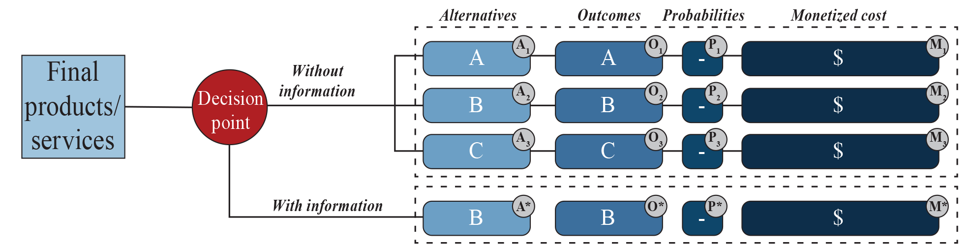
Illustration of the Bayesian decision-tree concept. Red circle represents decision points; a decision-maker could make one of many decisions and the alternatives are represented by A, B, and C as decision pathways. Each pathway has some probability of being chosen in a with and without information scenario (note that the without information scenario represents the next-best information because it is unlikely that there is no information at all). The decision is associated with an outcome and (when possible) a monetized cost (see Pearlman and others, 2019). Figure from Pearlman and others, 2019.
Foundational research on the VOI has focused on topics such as weather, earth observations, geospatial data for agriculture, natural disasters and natural hazards, and water quality. The value of weather information for agriculture production and management has been studied extensively (Lave, 1963; Johnson and Holt, 1986; Sonka and others, 1987; Babcock, 1990; Adams and others, 1995; Pielke, 1995; Nordhaus and Popp, 1997; Hersh and Wernstedt, 2001). One of the most cited VOI studies derived the VOI for hurricane data in 1986 (Nordhaus, 1986). Using a stated preference approach to elicit the value of Landsat satellite imagery, a major USGS information product, researchers found that Landsat images provided $2.19 billion (2011 U.S. dollars) in benefits in 2011 alone (Miller and others, 2013). To consider changes that have altered the demand for and supply of remotely sensed imagery, a recent update found that domestic and international users received an estimated $3.45 billion in benefits in 2017, with U.S. users accounting for $2.06 billion of those benefits (Straub and others, 2019). Another USGS study considered the potential benefits of enhanced elevation data, indicating as much as $13 billion in new annual benefits (Snyder, 2012); research on VOI of enhanced elevation data continues. Although stated preference surveys can provide critical information on the uses and value associated with scientific information, this technique is not always feasible due to time and resource constraints.
Another set of work has focused on VOI in the context of natural disasters and natural hazards. Using the Bayesian approach, researchers analyzed the VOI of geologic maps when used to enhance communication about home radon risks in Kentucky; they found that the additional information provided to homeowners changed behavior, resulting in 75 fewer people being exposed to harmful radon levels in one year, with a net present value of $3.4 to $8.5 million in avoided premature lung cancer mortality (Chiavacci and others, 2020). In another case study, USGS researchers assessed the value of avoided evacuation costs in the event of a Mauna Loa eruption on the island of Hawaiʻi. The change in precision from 1992 to 2017 when determining the pathway of lava flows due to enhanced elevation data is shown in figure 2 (Pindilli and Avery, 2018).
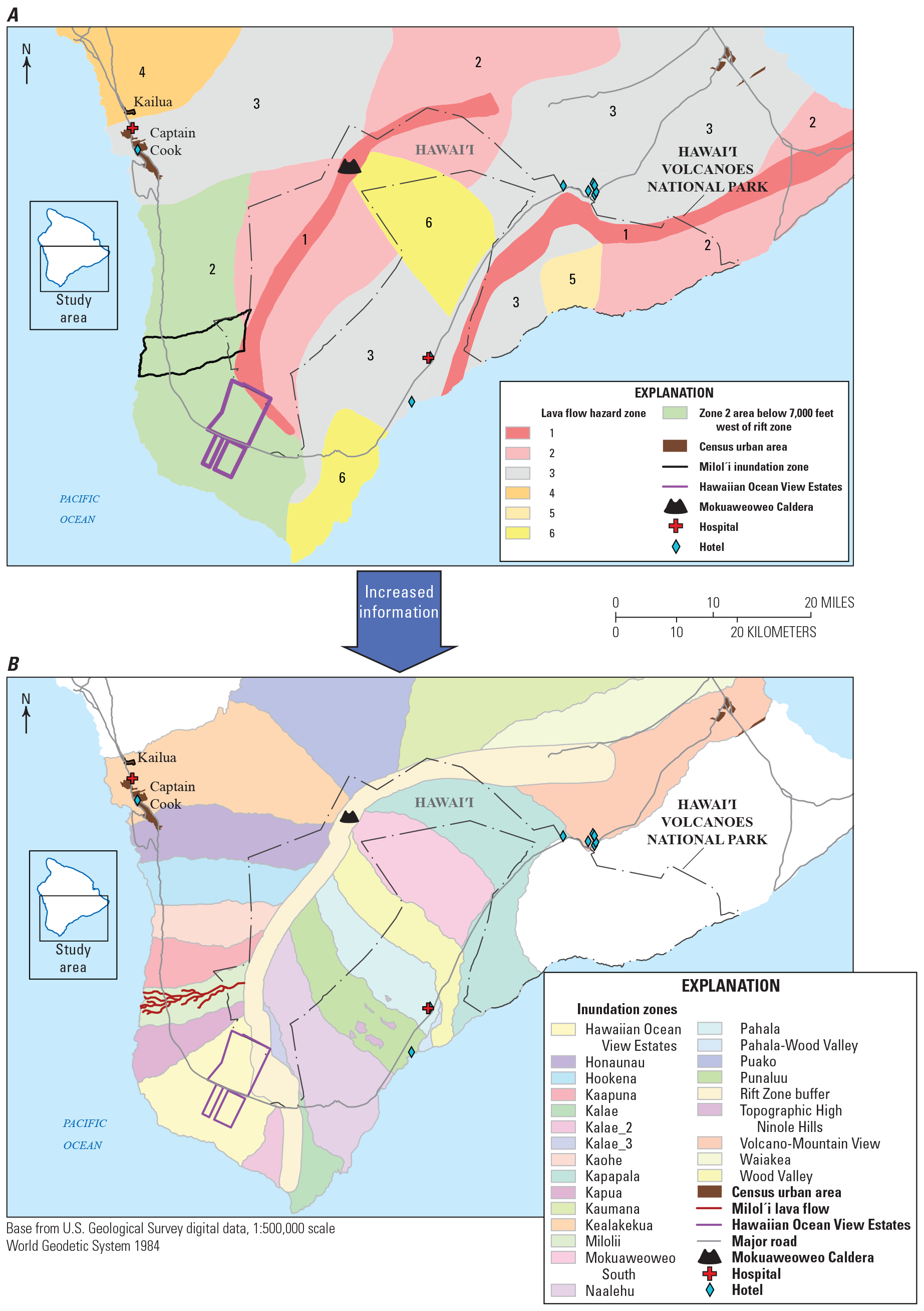
Mauna Loa volcano, Hawaiʻi, lava-flow hazard zone map from 1992 (upper panel) and lava-flow patterns inundation zone map from 2017 with enhanced elevation data and increased information about flow patterns (lower panel). Modified from Pindilli and Avery (2018).
Another area of ongoing research at the USGS is investigating the VOI for cyanobacteria harmful algal bloom (cyanoHAB) science. A valuation of a cyanoHAB early warning system for use in freshwater lake management is being conducted for Kansas and incorporates observations on the toxicity of cyanoHAB events and benefits that additional information would provide in terms of avoided foregone recreation and avoided human health effects (Pindilli and Loftin, 2022). A decision tree illustrating this case study is shown in figure 3.
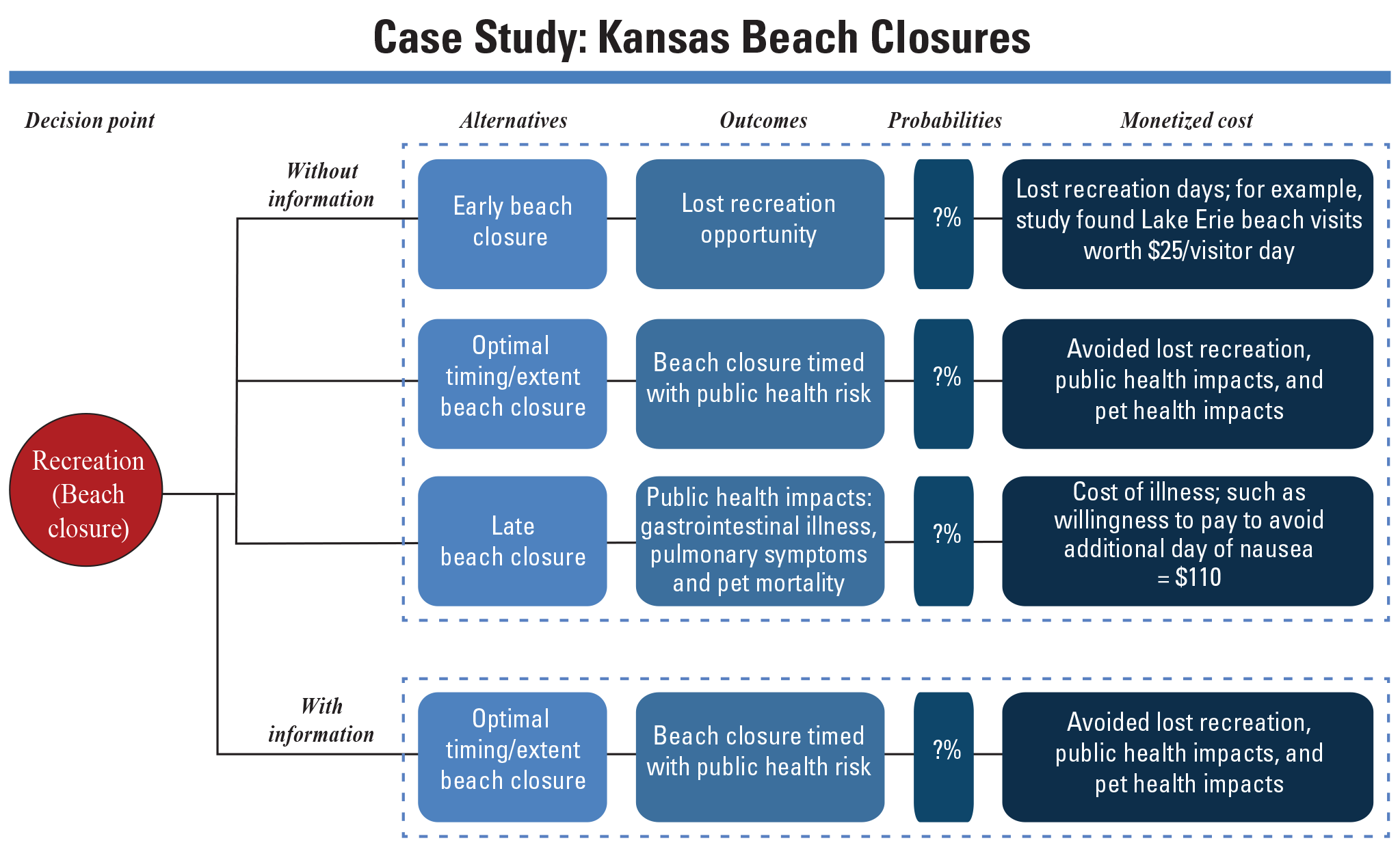
Flow chart of a Bayesian decision tree showing cyanobacteria harmful algal bloom early-warning system for freshwater lake management. Decision point (red circle) is whether or not to close a beach to recreation. Upper panel inside larger dotted rectangle shows possible decision pathways without additional information, including outcome of decisions, probability of that decision pathway (?% = unknown probability), and examples of monetized costs. The bottom panel represents the decision pathway with additional information. Modified from Pindilli and Loftin, 2022.
Conclusions and Future Directions
The effect of information for making better and more efficient decisions is of great importance in the Bayesian approach and is an important area of study for the USGS. Information and data generated through USGS research are used in both the private and public sectors for a variety of end-uses that may generate significant societal benefits. Evaluating these benefits by estimating the VOI is a unique topic within the field of economics, particularly for information that is provided as a public good because there is little likelihood that it will be traded in markets. VOI research requires multidisciplinary science to understand the role and use of information and may be best assessed by economists and social scientists in coordination with information providers, users of the information, and other stakeholders. This research draws on a base of foundational decision-science theory and welfare economics. USGS researchers are currently exploring the VOI related to the Landsat program, cyanoHAB information, and volcano science. Many additional opportunities to initiate VOI studies to support decision-making and prioritization on research and data collection efforts exist at USGS. Some of the key areas to initiate VOI studies at USGS include water availability and use information, energy and mineral availability and use, natural hazards science, and climate change information.
References Cited
Adams, R.M., Bryant, K.J., McCarl, B.A., Legler, D.M., O’Brien, J., Solow, A., and Weiher, R., 1995, Value of improved long-range weather information: Contemporary Economic Policy, v. 13, no. 3, p. 10–19, accessed January 10, 2023, at https://doi.org/10.1111/j.1465-7287.1995.tb00720.x.
Babcock, B.A., 1990, The value of weather information in market equilibrium: American Journal of Agricultural Economics, v. 72, no. 1, p. 63–72, accessed January 10, 2023, at https://doi.org/10.2307/1243145.
Chiavacci, S.J., Shapiro, C.D., Pindilli, E.J., Casey, C.F., Rayens, M.K., Wiggins, A.T., Andrews, W.M., Jr., and Hahn, E.J., 2020, Economic valuation of health benefits from using geologic data to communicate radon risk potential: Environmental Health, v. 19, no. 36, p. 1–9, accessed August 9, 2021, at https://doi.org/10.1186/s12940-020-00589-8.
Hersh, R., and Wernstedt, K., 2001, Gauging the vulnerability of local water utilities to extreme weather events—Discussion Paper 01-33: Washington, D.C., Resources for the Future web page, accessed January 10, 2023, at https://www.rff.org/documents/1276/RFF-DP-01-33.pdf.
Lave, L.B., 1963, The value of better weather information to the raisin industry: Econometrica, v. 31, no. 1/2, p. 151–164, accessed January 10, 2023, at https://doi.org/10.2307/1910954.
Macauley, M., and Laxminarayan, R., 2010, The value of information—‘Methodological Frontiers and New Applications for Realizing Social Benefit’ workshop: Space Policy, v. 26, no. 4, p. 249–251, accessed January 10, 2023, at https://doi.org/10.1016/j.spacepol.2010.08.007.
Miller, H.M., Richardson, L., Koontz, S.R., Loomis, J., and Koontz, L., 2013, Users, uses, and value of Landsat satellite imagery—Results from the 2012 survey of users: U.S. Geological Survey Open-File Report 2013–1269, 51 p., accessed August 9, 2021, at https://pubs.usgs.gov/of/2013/1269/pdf/of2013-1269.pdf.
Nordhaus, W.D., and Popp, D., 1997, What is the value of scientific knowledge?—An application to global warming using the PRICE model: The Energy Journal, v. 18, no. 1, p. 1–46, accessed January 10, 2023, at https://doi.org/10.5547/ISSN0195-6574-EJ-Vol18-No1-1.
Pearlman, F., Lawrence, C.B., Pindilli, E.J., Geppi, D., Shapiro, C.D., Grasso, M., Pearlman, J., Adkins, J., Sawyer, G., and Tassa, A., 2019, Demonstrating the value of Earth observations—Methods, practical applications, and solutions—Group on Earth Observations Side Event Proceedings: U.S. Geological Survey Open-File Report 2019–1003, 33 p., accessed August 9, 2021, at https://doi.org/10.3133/ofr20191033.
Pielke, R.A., Jr., 1995, Usable information for policy—An appraisal of the U.S. Global Change Research Program: Policy Sciences, v. 28, no. 1, p. 39–77, accessed January 10, 2023, at https://doi.org/10.1007/BF01000820.
Pindilli, E.J., and Loftin, K., 2022, What’s it worth? Estimating the potential value of early warnings of cyanobacterial harmful algal blooms for managing freshwater reservoirs in Kansas, United States: Frontiers in Environmental Science, v. 10, p. 805165, accessed January 10, 2023, at https://doi.org/10.3389/fenvs.2022.805165.
Snyder, G.I., 2012, National Enhanced Elevation Assessment at a glance: U.S. Geological Survey Fact Sheet 2012–3088, 2 p., accessed August 9, 2021, at https://pubs.usgs.gov/fs/2012/3088/.
Sonka, S.T., Mjelde, J.W., Lamb, P.J., Hollinger, S.E., and Dixon, B.L., 1987, Valuing climate forecast information: Journal of Climate and Applied Meteorology, v. 26, no. 9, p. 1080–1091, accessed January 10, 2023, at https://doi.org/10.1175/1520-0450(1987)026<1080:VCFI>2.0.CO;2.
Straub, C.L., Koontz, S.R., and Loomis, J.B., 2019, Economic valuation of Landsat imagery: U.S. Geological Survey Open-File Report 2019–1112, 13 p., accessed August 9, 2021, at https://doi.org/10.3133/ofr20191112.
Disclaimers
Any use of trade, firm, or product names is for descriptive purposes only and does not imply endorsement by the U.S. Government.
Although this information product, for the most part, is in the public domain, it also may contain copyrighted materials as noted in the text. Permission to reproduce copyrighted items must be secured from the copyright owner.
Suggested Citation
Pindilli, E., Chiavacci, S., and Straub, C., 2023, The value of scientific information—An overview: U.S. Geological Survey Open-File Report 2023–1011, 5 p., https://doi.org/10.3133/ofr20231011.
ISSN: 2331-1258 (online)
| Publication type | Report |
|---|---|
| Publication Subtype | USGS Numbered Series |
| Title | The value of scientific information — An overview |
| Series title | Open-File Report |
| Series number | 2023-1011 |
| DOI | 10.3133/ofr20231011 |
| Publication Date | February 14, 2023 |
| Year Published | 2023 |
| Language | English |
| Publisher | U.S. Geological Survey |
| Publisher location | Reston, VA |
| Contributing office(s) | Science and Decisions Center |
| Description | iii, 5 p. |
| Online Only (Y/N) | Y |
| Additional Online Files (Y/N) | N |