

Analysis of Aquifer Framework and Properties, North Magee Street Well Field, Southampton, New York
Links
- Document: Report (2.51 MB pdf) , HTML , XML
- Dataset: USGS National Water Information System database - USGS water data for the nation
- NGMDB Index Page: National Geologic Map Database Index Page (html)
- Download citation as: RIS | Dublin Core
Abstract
The U.S. Geological Survey, in cooperation with the Suffolk County Water Authority, evaluated the groundwater-flow characteristics and aquifer properties of the North Magee Street well field north of the village of Southampton, New York. Characteristics and properties included groundwater-flow direction, potential groundwater-contributing areas to the well field production wells, and aquifer transmissivity and storage. The groundwater flow and aquifer properties were also evaluated to allow Suffolk County Water Authority to better assess the potential source of dissolved halocarbons (refrigerants, such as chlorofluorocarbons).
The well field production wells are screened in the upper glacial aquifer and an observation well is screened in the Magothy aquifer. Based on depth and available logs, groundwater from wells screened in the upper glacial aquifer was classified as under water-table (unconfined) conditions, and groundwater from wells screened in the Magothy aquifer was classified as being under semiconfined conditions.
Groundwater flows radially to the well field during production and in a northwesterly direction under the effect of the regional flow regime. A previously published particle tracking analysis identified the following recharge contributing areas nearby the well field: (1) contributing areas to surface-water bodies of the Peconic Estuary, (2) contributing areas to surface-water bodies of the South Shore Estuary Reserve, (3) a contributing area to the Atlantic Ocean, and (4) a contributing area to another Suffolk County Water Authority well field. Five other pumping well contributing areas were identified within the study area, including those of various wells pumped for golf-course irrigation.
Analysis of drawdown and recovery data collected during the multiple-well aquifer test, through the application of a Neuman analytical model, provided estimates of upper glacial aquifer characteristics and properties. Inclusion of lateral aquifer boundaries was not necessary for the analysis to result in satisfactory matches with the observed water-level responses. Aquifer transmissivity was estimated to be 170,000 feet squared per day. Storativity was estimated to be 0.02 (dimensionless), and specific yield was estimated to be 0.08 (dimensionless), consistent with the inferred degree of confinement and well field characteristics.
Introduction
The U.S. Geological Survey (USGS), in cooperation with the Suffolk County Water Authority (SCWA), collected and analyzed groundwater levels and drilling logs in association with an aquifer test of the upper glacial aquifer at a well field north of the Tuckahoe School and south of Big Fresh Pond, Southampton, New York, (fig. 1) and reviewed previously published particle-tracking analyses of nearby recharge contributing areas (Misut and others, 2021). The study area includes the well field and the nearby surrounding area (fig. 1). The upper glacial aquifer underlying the study area was evaluated in cooperation with the SCWA as part of their investigation of the aquifers of Suffolk County (Misut, 2015). Evaluation of aquifer characteristics, including groundwater-flow direction and potential contributing areas, was desired in part because of the presence of dissolved chlorofluorocarbons in the well field water and nearby potential sources of chlorofluorocarbon contamination.
The well field area is underlain by outwash sand and gravel deposited in a glacial meltwater channel flanking Tuckahoe Hill (fig. 1), which is part of the Ronkonkoma moraine (moraine deposits are shown on figure 1; Nemickas and Koszalka, 1982). Tuckahoe Hill reaches an altitude of 127 feet (ft) above North American Vertical Datum of 1988 (NAVD 88) about 1,000 ft to the northeast of the well field, within a 160-acre nature preserve. Locally, to the northwest of the well field, kame sand and gravel pokes through the outwash, and recent marsh deposits overlie the outwash (fig. 1). The upper glacial aquifer in the area is about 150 ft thick and is underlain by the Magothy aquifer of Cretaceous age. The Magothy aquifer consists of about 750 ft of sand, silt, and clay. Maximum water-table altitudes are in the southeastern part of the study area rectangle (fig. 1; Como and others, 2015) that define a groundwater divide between groundwater flowing to the Peconic Bay and the Atlantic Ocean. As shown in the north-south section (fig. 2, A–A′), a freshwater/saltwater interface is represented by the Long Island regional groundwater-flow model at a depth of 350 ft below NAVD 88 (Walter and others, 2020). The aerially extensive Raritan confining unit underlies the Magothy aquifer and essentially forms a no-flow boundary at about 900 ft below NAVD 88.
The well field production wells are screened in the upper glacial aquifer. An observation well (S–73370.1; figs. 1–3) in close proximity to production well (S–79293.1) is screened in the Magothy aquifer for saltwater-intrusion monitoring. Production well S–133926.1 (figs. 1 and 2) is screened with a natural gravel-pack screen from 60 to 110 ft below NAVD 88. The two monitored production wells are screened from 37 to 87 and from 48 to 98 ft below NAVD 88 and the observation well is screened from 258 to 263 ft below NAVD 88. Each of the wells were instrumented with continuous water-level recorders. Production well S–133926.1 was pumped at a slightly varying rate of about 1,000 gallons per minute (gal/min) for 8 hours starting at 7:00 a.m. eastern standard time (EST) on January 23, 2020, ending at 3:10 p.m. on the same day. Groundwater levels in production wells 2, 3, and 4 (SCWA identification numbers; table 1) and the observation well (S–73370.1) were collected and analyzed as part of this study.
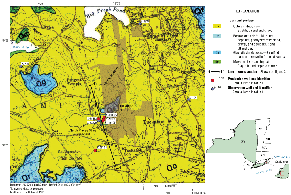
Map showing surficial geology and location of selected wells in the study area of the North Magee Street well field in Southampton, New York; modified from Nemickas and Koszalka (1982).
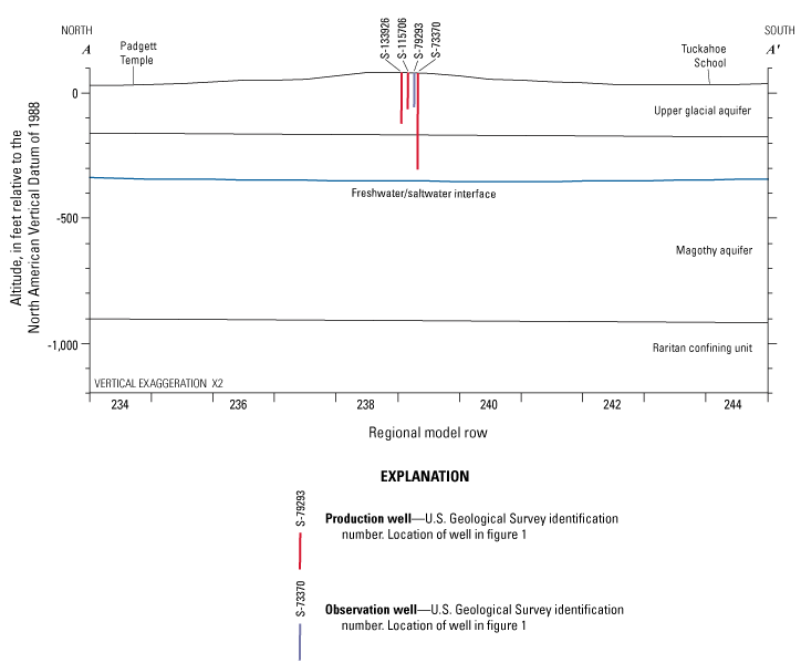
Geohydrologic section showing aquifer framework, freshwater/saltwater interface, and selected wells at the North Magee Street well field in Southampton, New York. Aquifer and confining-unit surfaces modified from Smolensky and others (1990) and freshwater/saltwater interface modified from Walter and others (2020). Regional model rows are 500 feet wide each. Location of section shown in figure 1.
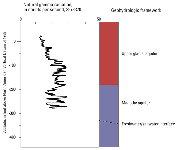
Graph showing gamma radiation log of well S–73370.1 and the aquifer framework at the North Magee Street well field in Southampton, New York. Data are from U.S. Geological Survey (2021).
Table 1.
Construction and aquifer information for selected wells in the study area at the North Magee Street well field in Southampton, New York.[Data are from U.S. Geological Survey (2021). All depths are below land surface. USGS, U.S. Geological Survey; NWIS, National Water Information System; ID, identification number; SCWA, Suffolk County Water Authority; Use: P, production; O, observation; Type: WT, water table; SC, semiconfined; ft, feet; NAVD 88, North American Vertical Datum of 1988; in., inch; —, not measured or not reported]
| USGS station name (fig. 1) |
NWIS ID | SCWA ID | Use | Land surface, in ft above NAVD 88 | Year drilled | Hole depth, in ft | Depth to top of screen, in ft | Depth to bottom of screen, in ft | Casing diameter, in in. | Well finish type | Aquifer condition type |
|---|---|---|---|---|---|---|---|---|---|---|---|
| S–74865.1 | 405411072251501 | 1 | P | 85 | 1983 | 220 | 134 | 189 | 20 | Screen | WT |
| S–79293.1 | 405411072251801 | 2 | P | 71 | 1985 | 344 | 104 | 155 | 16 | Screen | WT |
| S–73370.1 | 405412072252001 | 2T | O | 71 | 1982 | 344 | 325 | 330 | 4 | Screen | SC |
| S–115706.1 | 405411072251301 | 3 | P | 84 | 2000 | 190 | 115 | 155 | 20 | Screen | WT |
| S–164.1 | 405423072240801 | — | O | 76 | — | 123 | — | — | — | Boring | WT |
| S–8831.3 | 405507072244403 | — | O | 23 | — | 30 | — | — | — | Screen | WT |
| S–670.1 | 405443072261601 | — | O | 46 | — | 90 | — | — | — | Boring | WT |
| S–132299.1 | 405400072251401 | — | — | 41 | — | 238 | — | — | — | — | WT |
| S–133926.1 | 405412072251201 | 4 | P | 94 | 2016 | 212 | 155 | 210 | 20 | Screen | WT |
Regional Groundwater-Flow Patterns
On Long Island, water typically enters the groundwater-flow system as recharge at the water table, then flows to discharge points including estuaries and pumping wells. Regional groundwater-flow patterns and time of travel were simulated under steady-state present condition (from 2005 to 2015) using a numerical computer model coupled with particle tracking (Walter and others, 2020; Misut and others, 2021). Within the study area, the simulated time of travel from recharge at the water table to discharge (fig. 4) near the shoreline of Bullhead Bay (fig. 1) is less than 2 years. Five capture zones with less than 2-year simulated travel times are associated with pumping wells. The largest of these zones surrounds the North Magee Street well field. To the southwest of the North Magee Street well field, a smaller well capture zone than described above is associated with golf-course irrigation. Outside the well-capture zones are other zones of progressively longer simulated travel times. To the south and east of the well field, a band with simulated travel times of 500 to 1,000 years coincides with a regional groundwater divide. The divide separates groundwater flowing south to Atlantic Ocean estuaries and flowing north to the Peconic Estuary and Bullhead Bay (fig.1; Misut and others, 2021). The size and shape of other localized simulated divides, such as the divide between the contributing areas of the North Magee Street well field and an adjacent irrigation well to the south, are driven by numerous factors including proximity to discharge boundaries, aquifer hydraulic properties, and variation in the spatial distribution of recharge to the water table.
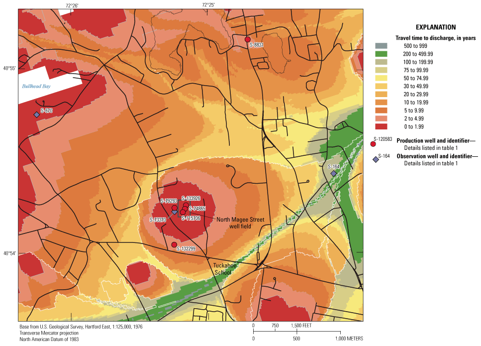
Map showing travel time to discharge of water entering the groundwater-flow system at the water table during steady-state present conditions (2005–15), North Magee Street well field, Southampton, New York. Modified from Misut and others (2021).
During steady-state present conditions (from 2005 to 2015), the simulated time of travel of water particles captured by the North Magee Street well field varies from less than 2 years within a radius of about 1,000 ft of the well field to less than 20 years within an oval of about 2,000 ft by 3,000 ft to greater than 100 years in a tail zone about 6,000 ft east from the well field. The simulated average velocity of regional flow in the upper glacial aquifer in areas outside of the effects of the production well is about 1 foot per day (ft/d).
Simulated water table contours during a steady-state present condition (from 2005 to 2015; Walter and others, 2020) are drawn with selected groundwater-flow directions in figure 5. Groundwater flows radially into the North Magee Street well field under the hydraulic effect of the average pumping rate from 2005 to 2015, as reported to the New York State Department of Conservation. Groundwater also flows towards the pumping well in a northwesterly direction under the effect of the regional groundwater-flow regime. The contributing area is about 0.7 square mile (mi2).
Areas contributing recharge to pumping wells and receiving water bodies may be delineated by tabulating end zones that are associated with particles beginning as recharge to the water table. Areas where simulated particles that begin at the water table and end at various pumping wells are shaded grey in figure 5, the North Magee Street well field is shaded grey and hatched. Six separate pumping well contributing areas are present within the study area, including three to golf-course irrigation wells. Most of the water captured by the North Magee Street well field is due to its zone of hydraulic effect; however, to the east, a fraction of capture is older than 50 years. This older groundwater flows towards the well field because of the natural (not affected by pumpage) regional flow regime. This groundwater-flow condition predates the steady-state present condition and may be more accurately simulated with the assumption of a steady-state predevelopment condition, as reported in Misut and others (2021).
Recharge contributing areas to surface-water bodies identified in Misut and others (2021) are variously colored in figure 5. The simulated contributing area to Bullhead Bay (dark blue) surrounds much of the North Magee Street well field to the north and west and includes a thin tail that wraps around the south side of the well field to cross the Tuckahoe School property. The simulated contributing area to Heady Creek (pink), part of the South Shore Estuary Reserve, is generally southwest of the regional groundwater divide near the Tuckahoe School but also includes a tail crossing the Tuckahoe School property. These tails intervene between the contributing area of the North Magee Street well field and that of another well field southeast of the Tuckahoe School. The complete delineation of simulated contributing areas that extend beyond figure 5 are given in Misut and others (2021). The size and shape of the tails depend, in large part, on well pumping rates. If pumping rates were increased beyond what is represented in the steady-state present conditions flow simulation, the tails would likely decrease in size. If pumping rates were decreased, the tails would likely increase in size. The average total pumping rate of the North Magee Street well field has decreased since the steady-state model period (2005 to 2015) which may have caused the contributing area tails to enlarge and shift north toward the well field.
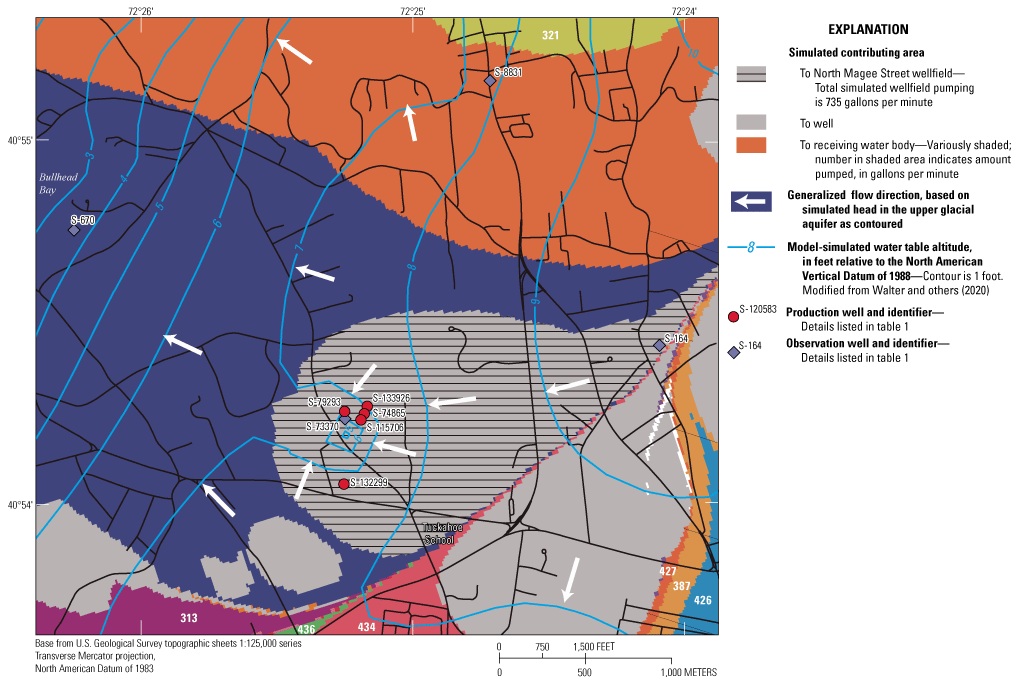
Map showing simulated areas of contribution and generalized flow directions during steady-state present conditions (from 2005 to 2015) at the North Magee Street well field in Southampton, New York. Modified from Misut and others (2021).
Well Inventory
The USGS inventoried wells and boreholes in the study area (fig. 1; table 1) to provide aquifer framework information. At the North Magee Street well field, lithologic and gamma radiation logs and well-construction drilling records indicated that well S–73370.1 was screened in the Magothy aquifer within an interval of fine to coarse sand with streaks of silty clay, lignite, and mica (U.S. Geological Survey, 2021). Well S–73370.1 was installed in the upper glacial aquifer to monitor the freshwater/saltwater interface. Specific conductance measurements during drilling of this well in 1982 indicated that the interface was at a depth of 390 ft below land surface. Production well S–79293.1 was screened in sand and gravel with streaks of brown silty clay within the same borehole in as well S–73370.1. Although no logs were available for other well field wells, their screen depths indicated that they are also screened in the upper glacial aquifer.
Beyond the North Magee Street well field, the well inventory included SCWA well S–132299.1 (fig. 1) at a nearby potential well field site that was subsequently abandoned. Additional boreholes, wells S164.1 and S670.1, were used in kriging a texture model that forms the basis of the Long Island regional groundwater-flow model hydraulic conductivity distribution (Walter and others, 2020). Northeast of the North Magee Street well field, water levels in shallow well S–8831.3, which is screened in brown silty sand, have been measured approximately monthly by the USGS since 2005 (U.S. Geological Survey, 2022).
Groundwater-Level Data Collection
In association with the aquifer test and in cooperation with the SCWA, the USGS monitored water levels in production wells S–133926.1, S–115706.1, and S–79293.1 and observation well S–73370.1 (fig. 1; table 1) from January 23 through January 28, 2020. Groundwater levels were recorded at 1-minute intervals using submersible vented pressure transducers (Freeman and others, 2004) and converted to depth in feet below the measuring point based on manual measurements with an electric water-level tape (Jelinski and others, 2015) at the time of installation and removal of the instrumentation. Measuring points were surveyed by the SCWA and used to convert water-level depths to water-level altitudes.
Groundwater-Level Analyses
Groundwater-level analyses were performed to verify aquifer framework conceptualization of the Long Island regional model (Walter and others, 2021) and to estimate aquifer hydraulic properties. Results of these analyses are presented in the sections below.
Aquifer Framework
The groundwater-level monitoring period included (1) stabilization of water levels before the beginning of the aquifer test on January 23, 2020; (2) drawdown related to the 8-hour period of controlled pumping from the production test well; and (3) a 27-hour period of water-level recovery following cessation of test-well pumping (fig. 6).
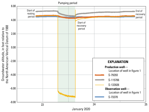
Graph showing water-level altitude in selected wells in the study area at the North Magee Street well field in Southampton, New York, from January 23 through January 24, 2020; data are available from the National Water Information System (U.S. Geological Survey, 2022).
Water levels in wells S–133926.1, S–115706.1, and S–79293.1 reflected the position of the water table in the upper glacial aquifer, and water levels in observation well S–73370.1 reflected the water level in the semiconfined Magothy aquifer. Based on the difference between these two sets of water level measurements, the water levels in the Magothy aquifer were slightly lower than water levels in the upper glacial aquifer during the monitoring period (January 23 through January 24, 2020).
After measuring water levels for about 24 hours before the beginning of pumping, water levels in upper glacial aquifer production well S–133926.1 drew down more than 10 ft when the well was pumped for 8 hours at a rate of 1,000 gal/min (fig. 7). A spike of about 1 ft above the final recovery water level resulted during the first 5 to 10 minutes after pumping ceased, because of backflow. Water levels in upper glacial aquifer production wells S–115706.1 and S–79293.1, 197 and 342 ft away, respectively, from the pumped well, drew down less than 1 ft. This result is consistent with the aquifer being under unconfined (water-table) conditions and highly transmissive. Water levels in well S–73370.1 screened in the Magothy aquifer, 342 ft from the pumped well, drew down less than 0.1 ft in response to the pumping of well S–133926.1. This result indicates a reduced hydraulic connection between the Magothy and upper glacial aquifers than that present within just the upper glacial aquifer.
Graph showing water-level change (drawdown and recovery) associated with the aquifer test in selected water-supply production wells at the North Magee Street well field in Southampton, New York, from January 23 through January 24, 2020.
Aquifer Characteristics and Properties
The analytical solution of Neuman (1974) for an aquifer test in an unconfined (water-table) aquifer was used for the quantitative analysis of the groundwater-level data. The following idealized aquifer and well conditions are assumed in the application of this analytical solution: the aquifer is unconfined with delayed gravity response, has infinite areal extent and uniform thickness (900 ft), and is homogeneous. Pumping and observation wells are partially penetrating, flow is radial to the pumping well, flow is unsteady, and storage within wells is negligible. Boundary conditions were not necessary to obtain satisfactory matches with the observed water-level changes in response to pumpage.
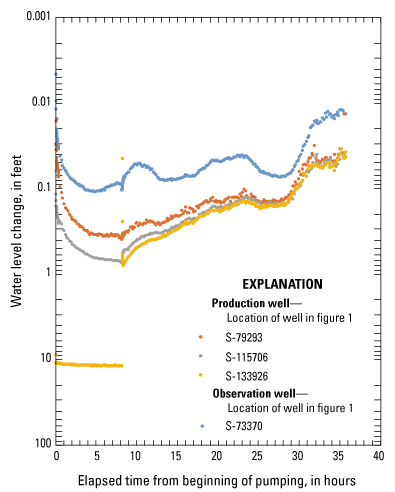
The aquifer properties of transmissivity, storativity, specific yield, and anisotropy ratio were estimated from the type-curve analysis using the computer program of Duffield (2007). The computer program performs nonlinear least-squares parameter estimation for automatic type-curve matching. A slightly varying pumping rate of about 1,000 gal/min from production well S–133926.1 during an 8-hour period was represented in the analysis. In addition, a 27-hour recovery period with no pumping was included in the water-level matching.
The water-level change data from wells S–133926.1, S–115706.1, S–79293.1, and S–73370.1 were matched with the Neuman analytical solution (fig. 8). The subsequent recovery data diverged slightly from ideal Neuman model-curve geometry. There may have been minor interference from an unknown offsite pumping well, such as a domestic, commercial, or institutional well on North Magee Street, possibly screened in the Magothy aquifer.
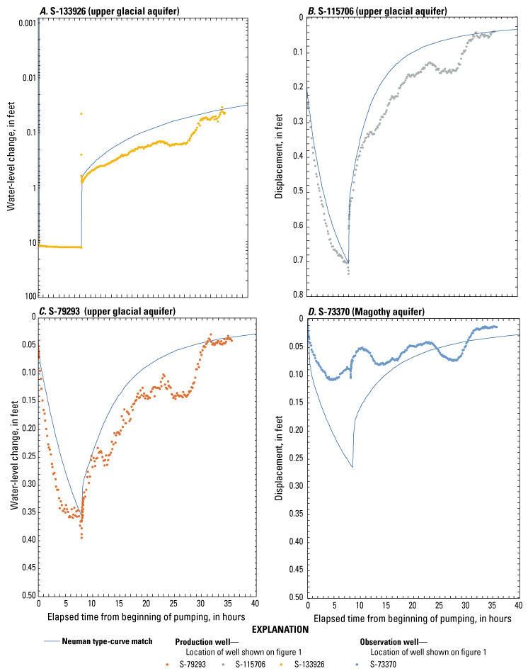
Graphs showing water-level change (drawdown and recovery) associated with the aquifer test and Neuman type-curve match for wells A, S–133926.1 (in the upper glacial aquifer), B, S–115706.1 (in the upper glacial aquifer), C, S–79293.1 (in the upper glacial aquifer), and D, S–73370.1 (in the Magothy aquifer) in the North Magee Street well field in Southampton, New York.
An aquifer transmissivity of 170,000 feet squared per day (ft2/d) with a vertical to horizontal anisotropy of 0.47 (dimensionless), storativity of 0.02, and specific yield of 0.08 (dimensionless) provided a satisfactory analytical match with the upper glacial aquifer water levels (U.S. Geological Survey, 2021). Additional trial-and-error model simulation indicated that the analytical match to the Magothy aquifer water levels might be improved slightly by decreasing transmissivity and storativity estimates. This result is consistent with the Magothy aquifer being less permeable and more confined than the upper glacial aquifer.
Summary
The U.S. Geological Survey, in cooperation with the Suffolk County Water Authority, evaluated the groundwater-flow characteristics and aquifer properties of the North Magee Street well field north of the village of Southampton, New York. The well field was selected, in part, because of the presence of dissolved chlorofluorocarbons and proximity to potential sources of chlorofluorocarbons.
Groundwater-flow characteristics and properties of the North Magee Street well field may be summarized as follows: groundwater flows radially into the well field under pumping stress and in general a northwesterly direction under the effect of the regional flow regime. During steady-state present conditions, including average pumping rates during 2005–15, the total simulated area contributing recharge to the well field is about 0.7 square mile. The following recharge contributing areas were identified nearby the well field: (1) contributing areas of surface-water bodies connected to the Peconic Bay, (2) contributing areas of surface-water bodies connected to the Atlantic Ocean, and (3) contributing areas to other pumping wells. Five other pumping well contributing areas were identified within the study area, including those of various golf-course irrigation wells. During 2005–15 hydrologic conditions, the simulated time-of-travel of water particles captured by the North Magee Street well field varied from less than 2 years within a radius of about 1,000 feet (ft) of the well field to less than 20 years within an oval of about 2,000 by 3,000 ft to greater than 100 years in a tail zone about 6,000 ft east of the well field. The simulated average rate of regional flow in areas outside of the effects of production well pumpage is about 1 foot per day.
In an aquifer test conducted as part of this study, analysis of water levels and drilling-record logs refined the regional aquifer framework. Of three production wells instrumented in the aquifer test, two wells are screened in the unconfined (water-table conditions) upper glacial aquifer (S–79293.1 and S–115706.1), and one well about 200 ft deeper, in the upper glacial aquifer (S–133926.1, pumped during this test). A fourth well classified as screened in the semiconfined Magothy aquifer (S–73370.1) was also monitored. Analysis of drawdown and recovery water-level data through the application of a Neuman analytical model provided estimates of aquifer characteristics and properties. The analysis resulted in satisfactory matches with observed water-level changes in response to pumpage, without the need for additional boundary conditions. Aquifer transmissivity was estimated to be 170,000 feet squared per day. Aquifer storativity was estimated to be 0.02 (dimensionless), and specific yield was estimated to be 0.08 (dimensionless), consistent with the degree of confinement and anisotropy in hydraulic conductivity in the aquifer.
References Cited
Como, M.D., Noll, M.L., Finkelstein, J.S., Monti, J., Jr., and Busciolano, R., 2015, Water-table and potentiometric-surface altitudes in the upper glacial, Magothy, and Lloyd aquifers of Long Island, New York, April–May 2013: U.S. Geological Survey Scientific Investigations Map 3326, 4 sheets, scale 1:125,000, 6 p., accessed March 21, 2023, at https://doi.org/10.3133/sim3326.
Freeman, L.A., Carpenter, M.C., Rosenberry, D.O., Rousseau, J.P., Unger, R.L., and McLean, J.S., 2004, Use of submersible pressure transducers in water-resources investigations: U.S. Geological Survey Techniques of Water-Resources Investigations, book 8, chap. A3, 52 p. [Also available at https://doi.org/10.3133/twri08A3.]
Jelinski, J., Clayton, C.S., and Fulford, J.M., 2015, Accuracy testing of electric groundwater-level measurement tapes: U.S. Geological Survey Open-File Report 2014–1236, 27 p., accessed March 21, 2023, at https://doi.org/10.3133/ofr20141236.
Misut, P.E., 2015, Technical pump-test evaluation of Suffolk County aquifers: U.S. Geological Survey data release, accessed March 21, 2023, at https://www.sciencebase.gov/catalog/item/55cde7e6e4b08400b1fe147a.
Misut, P.E., Casamassina, N.A., and Walter, D.A., 2021, Delineation of areas contributing groundwater and travel times to receiving waters in Kings, Queens, Nassau, and Suffolk Counties, New York: U.S. Geological Survey Scientific Investigations Report 2021–5047, 61 p., accessed March 23, 2023, at https://doi.org/10.3133/sir20215047.
Nemickas, B., and Koszalka, E.J., 1982, Hydrogeological appraisal of water resources of the south fork, Long Island, New York: U.S. Geological Survey Water-Supply Paper 2073, 55 p., 9 pls. [Also available at https://doi.org/10.3133/wsp2073.]
Neuman, S.P., 1974, Effect of partial penetration on flow in unconfined aquifers considering delayed gravity response: Water Resources Research, v. 10, no. 2, p. 303–312. [Also available at https://doi.org/10.1029/WR010i002p00303.]
Smolensky, D.A., Buxton, H.T., and Shernoff, P.K., 1990, Hydrologic framework of Long Island, New York: U.S. Geological Survey Hydrologic Investigations Atlas 709, 3 pls., scale 1:250,000. [Also available at https://doi.org/10.3133/ha709.]
U.S. Geological Survey, 2021, USGS GeoLog locator: U.S. Geological Survey database, accessed July 16, 2021, at https://webapps.usgs.gov/GeoLogLocator/.
U.S. Geological Survey, 2022, USGS water data for the nation: U.S. Geological Survey National Water Information System database, accessed December 2, 2022, at https://doi.org/10.5066/F7P55KJN.
Walter, D.A., Masterson, J.P., Finkelstein, J.S., Monti, J., Jr., Fienen, M.N., and Misut, P.E., 2020, Simulation of groundwater flow in the regional aquifer system on Long Island, New York, for pumping and recharge conditions in 2005–15: U.S. Geological Survey Scientific Investigations Report 2020–5091, 90 p., accessed December 2, 2022, at https://doi.org/10.3133/sir20205091.
Datums
Vertical coordinate information is referenced to the North American Vertical Datum of 1988 (NAVD 88) for wells drilled after 1988 and to the National Geodetic Vertical Datum (NGVD 29) for wells drilled before 1988; vertical coordinate information referenced to the NGVC 29 may be referred to as mean sea level (MSL).
Horizontal coordinate information is referenced to the North American Datum of 1983 (NAD 83).
Altitude, as used in this report, refers to distance above the vertical datum.
For more information, contact
Director, New York Water Science Center
U.S. Geological Survey
425 Jordan Road
Troy, NY 12180–8349
dc_ny@usgs.gov
or visit our website at
https://www.usgs.gov/centers/ny-water
Publishing support provided by the Pembroke Publishing Service Center
Disclaimers
Any use of trade, firm, or product names is for descriptive purposes only and does not imply endorsement by the U.S. Government.
Although this information product, for the most part, is in the public domain, it also may contain copyrighted materials as noted in the text. Permission to reproduce copyrighted items must be secured from the copyright owner.
Suggested Citation
Misut, P.E., 2023, Analysis of aquifer framework and properties, North Magee Street well field, Southampton, New York: U.S. Geological Survey Open-File Report 2023–1028, 14 p., https://doi.org/10.3133/ofr20231028.
ISSN: 2331-1258 (online)
Study Area
| Publication type | Report |
|---|---|
| Publication Subtype | USGS Numbered Series |
| Title | Analysis of aquifer framework and properties, North Magee Street well field, Southampton, New York |
| Series title | Open-File Report |
| Series number | 2023-1028 |
| DOI | 10.3133/ofr20231028 |
| Publication Date | June 05, 2023 |
| Year Published | 2023 |
| Language | English |
| Publisher | U.S. Geological Survey |
| Publisher location | Reston, VA |
| Contributing office(s) | New York Water Science Center |
| Description | Report: iv, 14 p.; Dataset |
| Country | United States |
| State | New York |
| City | Southampton |
| Online Only (Y/N) | Y |
| Additional Online Files (Y/N) | N |