

Re-Prioritization of the U.S. Geological Survey Federal Priority Streamgage Network, 2022
Links
- Document: Report (1.51 MB pdf) , HTML , XML
- Data Release: USGS data release - Federal stakeholder 2022 online survey results for the re-prioritization of the U.S. Geological Survey Federal Priority Streamgage Network
- Version History: Version History (5 KB txt)
- Download citation as: RIS | Dublin Core
Abstract
The Federal Priority Streamgage (FPS) network of the U.S. Geological Survey (USGS), created in 1999 as the National Streamflow Information Program (NSIP), receives Congressional appropriations to support the operation of a federally-funded “backbone” network of streamflow gages across the United States that are designated to meet the “Federal needs” or priorities of the country. Anticipating the evolution of Federal stakeholder water-data needs, the USGS launched a re-evaluation of the fundamental priorities for the FPS network in October 2021. In March 2022, the FPS Re-Prioritization Project used an online survey to solicit feedback from 767 stakeholders representing 22 Federal agencies who benefit from the FPS network. Additional feedback from survey respondents was obtained during online listening sessions to validate the USGS’s understanding of current Federal water-data needs. Results of the feedback show that the original five network priorities identified by the U.S. Geological Survey in 1999 are still valid but require modification to better incorporate additional needs, including Federal water operations, streamflow trends and extremes, water rights involving Federal lands, and streamflow data supporting ecosystem health. Federal stakeholder feedback also indicated that the inclusion of precipitation and water-temperature data collection, along with stream imagery, would enhance the value of the FPS network.
Results of the FPS Re-Prioritization Project and Open Season that ended in May 2024 revealed that the number of FPS locations meeting the updated eligibility criteria nearly tripled, which illustrates the value of the information provided by the FPS network. The Water Forecasting & Operations and the Water Quality network priorities contributed to the largest number of new eligible FPS sites, demonstrating the importance of the FPS network in supporting informed decisions related to the protection of life, property, the environment, and the economy of the United States.
Introduction
The Federal Priority Streamgage (FPS) network—originally called the National Streamflow Information Program (NSIP)—was conceived in 1999 to allow the U.S. Geological Survey (USGS) to operate a stable, fully federally-funded “backbone” network of streamflow gages to provide reliable, accurate, and timely streamflow data to serve Federal needs across the country. The streamflow data serve multiple Federal needs such as public safety, infrastructure design, and water-resource management. It is also recognized that the FPS network concurrently serves multiple needs of many other stakeholders beyond the Federal community. Partial funding for NSIP was first allocated in 2000 and continues at a level that is currently (October 2022) sufficient to fully fund the operation of approximately 1,430 streamflow gages (out of a total of 4,758 eligible streamflow-gage locations), or roughly one-third of all eligible locations. The locations and funding status of current streamflow gages in the FPS network can be found online (https://water.usgs.gov/networks/fps/).
Recognizing that new technologies have developed in the 20 years since the FPS (formerly NSIP) was initiated, an FPS Advisory Group consisting of USGS Water Science Center (WSC) Directors, Data Chiefs, and the National Streamflow Network Coordinator was tasked to review the original FPS network design criteria. This team performed a detailed internal review of the network and identified several potential design improvements. The USGS Water Mission Area (WMA) Executive Council realized that revisions of network priorities should also be driven by input from Federal agency stakeholders that rely on USGS water data. Considering Federal stakeholder input also provided the USGS an opportunity to determine interest in data types that may not have been feasible or practical to include within the FPS network as originally designed.
In the fall of 2021, the USGS initiated the FPS Re-Prioritization Project to develop a strategy to solicit feedback from Federal agency stakeholders on best approaches to modernize the FPS network. This engagement with Federal agency stakeholders will evolve the FPS network to better fulfill its goal as the federal-supported backbone of streamflow gages that benefits all public and private stakeholders into the next decade and beyond.
This report has been revised to include a description of the implementation of the new FPS priorities established by the Re-Prioritization Project. This implementation phase, called the FPS Open Season, involved reassessing the entire existing USGS streamgaging network, as well as the eligibility of potential new streamgage locations for inclusion in the updated FPS network design. The FPS Open Season lasted from December 2023 through May 2024, and involved staff from all USGS WSC offices engaging with their local federal partners to submit a list of proposed streamgage locations for inclusion in the 2024 FPS network design according to provided guidance. Submissions were assimilated and reviewed by the FPS Advisory Group who then finalized the 2024 FPS network design that is published in this report revision. Results of the Re-Prioritization and Open Season revealed that the number of FPS locations meeting the updated eligibility criteria nearly tripled, which illustrates the current value of the information provided by the FPS network related to the protection of life, property, the environment, and the economy of the United States.
Background
The FPS network was initiated in 1999 (as the NSIP) in response to a 1998 request from Congress, motivated by a noted steady decline in the number of active and long-term streamflow gages across the nation. A subsequent Bales and others (2004) analysis of the network recommended the periodic re-evaluation of the network to ensure that it meets future needs for streamflow information. A U.S. Government Accountability Office (2005) report recommended that a cost-benefit analysis could point to changes in the design or operation of the network that could enhance the level of benefits the network provides. Two independent reports (Hester and others, 2006a; Hester and others, 2006b), published by the National Hydrologic Warning Council, helped articulate the value that USGS streamflow gages provide to the country.
The FPS network is intended to be a federally-funded backbone or subset of the overall USGS National Streamgaging Network, which provided streamflow and water-level information from about 8,500 locations across the country in 2020. The FPS is intended to aid in decision-making regarding long-term national priorities that may not be supported if the network was funded by non-federal sources concerned primarily with local, short-term, or changing goals. Examples of these Federal interests include monitoring international boundary or interstate compact-governed streamflows. The original FPS network design, as seen in U.S. Geological Survey (1999) was intended to support five Federal priorities (table 1).
Table 1.
Original Federal Priority Streamgage (FPS; formerly National Streamflow Information Program [NSIP]) Federal priorities with descriptions.FPS Re-Prioritization Project
The FPS Re-Prioritization Project, initiated in the fall of 2021, was done to gather input from Federal stakeholders on streamflow-gaging priorities. The scope of the project included three tasks:
-
1. distributing an online survey to Federal stakeholders to identify their streamflow-gaging priorities and data needs,
-
2. hosting a set of virtual listening sessions to validate the online survey results, and
-
3. compiling survey and listening session results into a final publication.
Federal Stakeholder Online Survey
The first task in the project scope required the compilation of Federal stakeholders while a proposed online survey was developed. Compilation of the contact list of Federal agency stakeholders to be surveyed was accomplished in collaboration with managers from USGS WSCs, Regions, and WMA offices. Development of the online stakeholder survey was aided by input from national network managers and the FPS Advisory Group. Final adjustments to the survey structure and format were provided by a team of USGS social scientists and outreach specialists.
The online survey was distributed to 767 Federal agency stakeholders, with results collected from 325 respondents (42 percent) representing 22 Federal agencies and 7 Executive Branch departments from March 14 through April 14, 2022. Respondents were asked to select from pre-determined lists of Federal priorities and data needs (Appendix 1) then rank their selections in order of importance to their agency mission. Each list also contained an “Other” option to allow respondents to add at their discretion any important priorities or data needs not included in the lists provided.
Respondents were asked to rank their selections from each list by distributing 100 points among each set of selections, with higher-ranking selections receiving more points. The result was a set of ranked priorities and data types from each respondent. The survey also solicited additional comments to allow respondents to share any further information pertinent to the purpose of the survey. Results are compiled in a separate data release (Dillow and others, 2023).
Federal Stakeholder Listening Sessions
After the preliminary results were compiled and analyzed, a series of voluntary listening sessions were scheduled to share those results with Federal agency stakeholders and allow them the opportunity to provide further feedback to the USGS indicating whether the survey results validated their priorities and data needs. A total of eight listening sessions were held between May 13 and June 28, 2022. Feedback received during each listening session was documented and incorporated into the overall analysis.
Compilation of Online Survey and Listening Session Feedback
Following the survey and listening sessions, all results and comments were analyzed to derive a summary of stakeholder preferences regarding revisions to FPS network priorities and potential new data types a modern FPS network could serve. These analyses and considerations include the distinction between specific Federal agency needs and broader Federal needs. This distinction is important because specific Federal agency needs, while rational and valid, can be unique to individual stakeholders while not serving the interests of multiple stakeholders and the public consistent with the principles supporting the original FPS network.
Within the survey responses, long-term streamflow trends, water forecasting, and floodplain management were the three most popular priorities, accounting for over 36 percent of all ranking points assigned amongst the priorities listed in the survey (fig. 1).
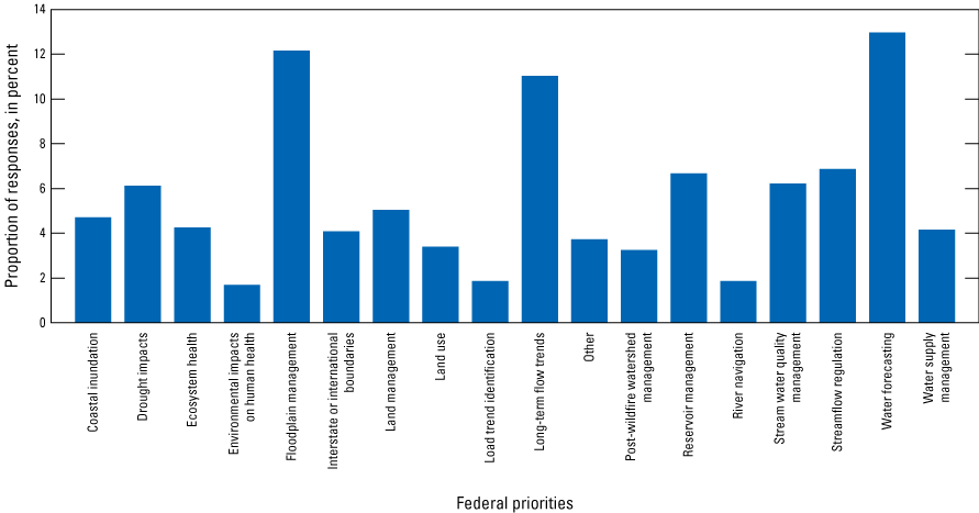
Bar chart showing Federal priorities with survey preference proportions.
Survey responses pertaining to data needs identified that precipitation, stream imagery, and water temperature were the three most popular data types, accounting for over 46 percent of all ranking points assigned amongst the data types listed in the survey (fig. 2).
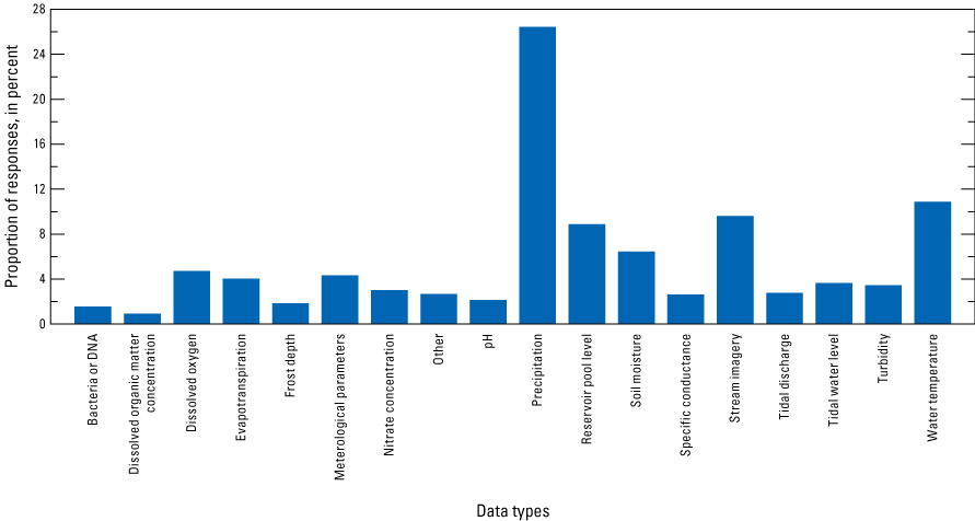
Bar chart showing Federal data needs with survey preference proportions.
Other important considerations noted in the survey responses come from the emphasis seen in both the “Other” responses, and the content of the “Additional Comments” received. Among individual responses touching on various topics, the “Other” responses included multiple instances of issues relating to both “Water rights” and “Ecosystem health” (aquatic habitat, habitat restoration, and stream restoration). Among the 45 substantive responses submitted in the “Additional Comments” section of the survey there were several themes not otherwise included in the survey results that were mentioned multiple times, including support for:
-
• operation of sentinel or reference streamflow gages,
-
• monitoring in small watersheds,
-
• monitoring to facilitate adjudication of water-rights disputes at boundaries separating Federal lands from those of other jurisdictions, and
-
• monitoring to characterize sediment transport.
Further feedback received during the listening sessions was both positive and constructive, and contained some recurring themes. Specifically, there was general and consistent agreement that the original five Federal priorities governing the FPS network are still relevant to today’s water-data needs, and that the results of the survey (as presented) emphasized additional priorities and data needs considered appropriate by participating stakeholders. Additional priorities and data needs mentioned multiple times during the listening sessions included:
-
• water rights or water supply at Federal land boundaries (sometimes associated with Endangered Species Act issues),
-
• groundwater or spring effects on base flow in streams in arid regions,
-
• soil moisture (particularly in relation to snowpack),
-
• dissolved-oxygen concentration (in relation to fish migration), and
-
• stage (or some surrogate) data to better describe ice presence and thickness in stream channels.
Results
The feedback received from both the Federal stakeholder survey and the subsequent voluntary listening sessions provides sufficient evidence to support updating both the Federal priorities and the water-data parameters collected to serve Federal data needs. Stakeholder feedback verified that the original Federal priorities and data parameters served by the network are still valuable and necessary. Revisions will be accomplished by modifying the original five priorities to encompass the additional needs.
Consistent with the feedback received from the stakeholders, the impact of the priority revisions will be to expand the needs that the re-prioritized FPS network can serve, while preserving the original functionality relating to streamflow and water-level information. Subsequent to the publication of this report, a design framework consisting of monitoring-network characteristics, geographic-information resources and quantitative decision metrics will be created by the FPS Advisory Group to facilitate network reconfiguration consistent with the revised network priorities. The framework will be used by USGS WSC staff and their Federal partners to make decisions about FPS site eligibility and operational priorities.
Updated FPS Federal Priorities
Based on the survey results and comments received during the subsequent listening sessions, the original five priorities governing the current FPS network are still valid with some slight updates. As seen in table 2, the resulting updates support inclusion of the following revised FPS priorities:
-
• water-rights issues relating to Federal land management,
-
• stream-ecosystem health impacted (or affected) by stream restoration or management on Federal lands, and
-
• Federal reservoir operational impacts on water supply.
Table 2.
Updated Federal Priority Streamgage (FPS) Federal priorities with descriptions.Additional Federal Data Needs
The results of the survey and feedback received during the voluntary listening sessions indicate that the preferences for additions to the data types eligible to be served by the re-prioritized FPS network are clear and strong. They indicate that precipitation, water temperature, and stream imagery (still imagery or video) are considered valuable enough that they should be included in the FPS network. All three data types, in addition to water-level and streamflow data collection, are considered valid within the definition of Federal needs and are within the technical capacity of the USGS to serve using existing monitoring technology and telemetry systems. As previously stated, implementation of these parameters would be site specific and only as available funding allows.
The FPS Open Season
Following the publication of the new FPS network priorities in spring 2023, the next step toward redesigning the FPS network involved establishing a standardized process for USGS WSCs to engage with their local federal partners and determine the locations for the updated FPS network design. This process, known as the FPS Open Season, was developed by creating site-selection criteria based on the specific survey results that informed the five new FPS priorities. The high-level goals of the FPS Open Season included:
-
1. Developing a new FPS network design using the updated priorities,
-
2. Increasing the number of locations that met multiple priorities to aid in ranking eligible sites, and
-
3. Ensuring our federal partners were engaged throughout the process.
The FPS Advisory Group created guidance for the FPS Open Season using specialized basin coverage layers designed in the National Water Dashboard-internal application to spatially analyze and filter USGS streamgaging network maps in accordance with the established priorities and site selection criteria. Examples of some specialized layers included mid-size basins without an FPS station, tide gage network gaps from the National Ocean Service (Brent Ache, National Ocean Service, written comm., 2023), and federal land boundaries. Spreadsheets were developed for staff in each of the 28 local USGS WSCs to document sites for inclusion in the new FPS network, propose parameters and estimated costs for each site, and record federal partner contact information along with supporting notes.
Using these tools, staff in each local WSC 1) evaluated their original FPS site list from the 2000 network design to confirm that each site still aligned with the new FPS priorities; 2) reviewed the proposed sites from the 2000 network design to determine their continued relevance with the new FPS priorities; and 3) identified new site locations to be included in the new 2024 network design based on the updated FPS eligibility criteria and feedback from their federal partners. The FPS Open Season spanned six months, from the beginning of December 2023 to the end of May 2024.
Beginning in June 2024, the process of consolidating the spreadsheet received from each USGS WSC into a single master spreadsheet commenced. This involved eliminating duplicate site entries and rectifying any missing or incorrectly formatted metadata. Once a verified master spreadsheet was created, each site was analyzed to ensure that its FPS priority assignment adhered to the updated site selection criteria. The FPS Advisory Group oversaw this process to ensure that the analysis was conducted fairly and justifiably.
The final 2024 FPS network design received approval from the FPS Advisory Group in October 2024. The 2024 network design can be viewed at: https://water.usgs.gov/networks/fps/. A link to the original 2000 FPS network design is available at this location as well.
The Water Forecasting & Operations priority now has almost 8,000 locations in the FPS 2024 network, while the Water Quality priority increased to more than 4,900 locations. The Water Budgets priority had the smallest change with now more than 530 locations.
Following the open season effort, feedback from local USGS WSCs was overwhelmingly positive and highlighted increased interactions with federal partners and enhanced understanding of the needs addressed by the updated FPS network.
Summary
The Federal Priority Streamgage (FPS) network receives congressionally-appropriated funding to support the operation of a federally-funded “backbone” network of streamflow gages across the United States. Anticipating the evolution of stakeholder water-data needs since its inception in 1999, and advances in monitoring and communication technologies, the USGS launched discussions to re-evaluate the fundamental priorities for the FPS network in 2020. The FPS Re-Prioritization Project, initiated in 2021, used an online survey to solicit feedback from 767 Federal agency stakeholders representing 22 Federal agencies who benefit from the FPS network so it can better serve their needs in the next decade. Additional feedback from survey respondents was obtained during online listening sessions to validate the USGS’s understanding of current Federal water-data needs. A USGS team used the feedback to determine that the original five network priorities are still valid but required modifications to better incorporate additional needs, including Federal water operations, streamflow trends and extremes, water rights involving Federal lands, and streamflow data supporting ecosystem health. Federal stakeholder feedback also indicated that the inclusion of precipitation and water-temperature data collection, along with stream imagery, would greatly enhance the value of the FPS network. The FPS Open Season occurred from December 1, 2023 to May 31, 2024, and used a collaborative process with federal partners to evaluate the existing FPS network locations and potential new locations according to the new site selection criteria. The FPS Open Season network evaluation resulted in a new 2024 FPS network design. Results of the Re-Prioritization and Open Season revealed that the number of FPS locations meeting the updated eligibility criteria nearly tripled, which illustrates the current value of the information that the FPS network provides. The Water Forecasting & Operations and the Water Quality network priorities contributed to the largest number of new eligible FPS sites, demonstrating the importance of the FPS network in supporting informed decisions related to the protection of life, property, the environment, and the economy of the United States.
References Cited
Bales, J.D., Costa, J.E., Holtschlag, D.J., Lanfear, K.J., Lipscomb, S., Milly, P.C.D., Viger, R., and Wolock, D.M., 2004, Design of a National Streamflow Information Program Report with recommendations of a Committee—Reston, Va.: U.S. Geological Survey Open-File Report 2004–1263, 42 p., accessed December 20, 2022, at https://doi.org/10.3133/ofr20041263.
Dillow, J.J., McCallum, B.E., Angeroth, C.E., and Staub, L.E., 2023, Federal stakeholder 2022 online survey results for the re-prioritization of the U.S. Geological Survey Federal Priority Streamgage Network: U.S. Geological Survey data release, https://doi.org/10.5066/P9RJF8C8.
Hester, G., Carsell, K., and Ford, D., 2006a, Benefits of USGS Streamgaging Program—Users and uses of USGS streamflow data: National Hydrologic Warning Council, prepared by David Ford Consulting Engineers, Inc., 17 p., accessed December 14, 2022, at https://water.usgs.gov/osw/pubs/nhwc_report.pdf.
Hester, G., Ford, D., Carsell, K., Vertucci, C., and Stallings, E.A., 2006b, Flood management benefits of USGS streamgaging program: National Hydrologic Warning Council, prepared by David Ford Consulting Engineers, Inc., 48 p., accessed December 14, 2022, at https://water.usgs.gov/osw/pubs/Flood_Management_benefits_complete.pdf.
U.S. Geological Survey, 1999, Streamflow information for the next century—A plan for the National Streamflow Information Program of the U.S. Geological Survey: U.S. Geological Survey Open-File Report 99–456, 13 p., accessed December 20, 2022, at https://doi.org/10.3133/ofr99456.
U.S. Government Accountability Office, 2005, Environmental information—Status of federal data programs that support ecological indicators: U.S. Government Accountability Office Report GAO-05-376, 183 p., accessed December 20, 2022, at https://www.gao.gov/assets/gao-05-376.pdf.
Appendix 1. Federal Stakeholder Online Survey Questions
Federal Priority Streamgage Priority Options Posed to Federal Stakeholders
-
Interstate or international waters legal/treaty obligation compliance
-
Water forecasting
-
Water-supply management
-
Long-term flow-trend identification
-
Load-trend identification
-
Coastal inundation effects
-
Drought impacts
-
Ecosystem health or services maintenance
-
Environmental impacts on human health
-
Floodplain management or inundation mapping
-
Land management
-
Land-use change impacts
-
Reservoir management
-
River navigation
-
Streamflow regulation
-
Stream-water quality management
-
Post-wildfire watershed monitoring
-
Other
Federal Priority Streamgage New Data Collection Possibilities Posed to Federal Stakeholders
-
• Dissolved-organic-matter concentration
-
• Dissolved-oxygen concentration
-
• Evapotranspiration
-
• Frost depth
-
• Meteorological parameters (non-precipitation)
-
• Nitrate concentration
-
• pH
-
• Precipitation
-
• Reservoir pool level or tailrace flows
-
• Soil moisture
-
• Specific conductance
-
• Stream-condition imagery (still photos, streaming video)
-
• Tidal discharge
-
• Tidal water level
-
• Turbidity
-
• Water temperature
-
• Bacteria or DNA
-
• Other
For more information, contact:
Director, Observing Systems Division
U.S. Geological Survey Water Mission Area
12201 Sunrise Valley Drive
Reston, Virginia 20192
Or visit our website at https://www.usgs.gov/mission-areas/water-resources.
Publishing support provided by the Baltimore Publishing Service Center.
Disclaimers
Any use of trade, firm, or product names is for descriptive purposes only and does not imply endorsement by the U.S. Government.
Although this information product, for the most part, is in the public domain, it also may contain copyrighted materials as noted in the text. Permission to reproduce copyrighted items must be secured from the copyright owner.
Suggested Citation
Dillow, J.J.A., McCallum, B.E., and Angeroth, C.E., 2023, Re-prioritization of the U.S. Geological Survey Federal Priority Streamgage Network (ver. 1.1, April 2025): U.S. Geological Survey Open-File Report 2023–1032, 7 p., https://doi.org/10.3133/ofr20231032.
ISSN: 2331-1258 (online)
Study Area
| Publication type | Report |
|---|---|
| Publication Subtype | USGS Numbered Series |
| Title | Re-prioritization of the U.S. Geological Survey Federal Priority Streamgage Network, 2022 |
| Series title | Open-File Report |
| Series number | 2023-1032 |
| DOI | 10.3133/ofr20231032 |
| Edition | Version 1.0: April 2023; Version 1.1: April 2025 |
| Publication Date | April 07, 2023 |
| Year Published | 2023 |
| Language | English |
| Publisher | U.S. Geological Survey |
| Publisher location | Reston, VA |
| Contributing office(s) | WMA - Observing Systems Division, Maryland-Delaware-District of Columbia Water Science Center |
| Description | Report: iii, 7 p.; Data Release |
| Country | United States |
| Online Only (Y/N) | Y |
| Additional Online Files (Y/N) | N |