

Implementation Plan of the National Cooperative Geologic Mapping Program Strategy—Northeast Region of the United States: New York and New England
Links
- Document: Report (21.2 MB pdf) , HTML , XML
- NGMDB Index Page: National Geologic Map Database Index Page (html)
- Download citation as: RIS | Dublin Core
Abstract
Complexly deformed igneous, metamorphic, and sedimentary rocks form the bedrock of the Northeast region of the United States. Variably thick unconsolidated sediments deposited by glacial, fluvial, and eolian systems locally cover the bedrock. New geologic mapping focuses on areas lacking modern, detailed studies or syntheses, and contributes to existing framework research. This report addresses plans for the continued development of regionally and nationally consistent geologic maps and map databases, efforts to answer outstanding geologic questions, and societal concerns associated with related geologic topics, such as hazards, geologic and hydrologic resources, and environmental issues.
Introduction
In 2021, the National Cooperative Geologic Mapping Program (NCGMP), authorized by the National Geologic Mapping Act of 1992 (Public Law 102–285 as amended, 106 Stat. 166), published a strategic plan titled “Renewing the National Cooperative Geologic Mapping Program as the Nation’s Authoritative Source for Modern Geologic Knowledge” (Brock and others, 2021). The plan provides a vision, mission, and goals for the program for 2020–2030. The NCGMP developed this implementation plan as a way to promote the goals outlined in the strategic plan. This implementation plan intends to inform the annual review of projects carried out by U.S. Geological Survey (USGS) staff through FEDMAP—as described in the strategic plan and through the development of the annual FEDMAP prospectus—to ensure effective application of the NCGMP strategy.
This report is part of the implementation plan of the NCGMP strategy. Implementation plans by Langenheim and others (2021) and Merschat and others (2022) guided the development of this current implementation plan. This region-specific report addresses three focal points:
-
1. continued development of nationally consistent geologic maps and map databases,
-
2. major unanswered geologic questions within the region, and
-
3. societal concerns associated with related geologic questions, such as hazards, geologic and hydrologic resources, and environmental matters.
The Northeast region is underlain by glaciated, complexly deformed crystalline igneous and metamorphic rocks and sedimentary rocks; it is variably covered by unconsolidated sediments deposited by continental glaciers, glaciofluvial meltwaters, periglacial conditions, modern fluvial systems, and wind. New geologic mapping focuses on areas lacking detailed or modern maps. New maps contribute to framework studies that help characterize water availability, groundwater behavior and groundwater contaminants in fractured rock and glacial sediments, distribution of mineral and aggregate resources, coastal flooding and natural hazards—such as landslides and river valley evulsion due to extreme weather events—and address outstanding questions about the tectonic evolution of ancient mountain belts. New large-scale geologic maps include detailed fracture information for characterizing the recharge potential of bedrock lithologies and identifying potential pathways for groundwater and contaminant flow. All of these geologic mapping activities are supported by modern geochemistry, geochronology, and paleontology in scientifically appropriate areas.
Geologic Setting
The Northeast region, in this report, includes New York and the six New England States (fig. 1). The physiography primarily includes the Adirondack Mountains and the New England section of the northern Appalachian Highlands but also includes the St. Lawrence and Champlain Valleys (fig. 2). In New York, the region overlaps with the Appalachian Plateau and Valley and Ridge provinces and the Great Lakes-Central Lowland provinces.
Bedrock geologic map of the Northeast region of the United States including New York and the six New England States showing the bedrock geology compiled from the State geologic maps and index to 30- x 60-minute quadrangles. Geology from Fisher and others (1970), Zen and others (1983), Osberg and others (1985), Rodgers (1985), Hermes and others (1994), Lyons and others (1997), and Ratcliffe and others (2011), compiled from the digital files available from the U.S. Geological Survey Mineral Resources On-Line Spatial Data website (https://mrdata.usgs.gov/geology/state/).
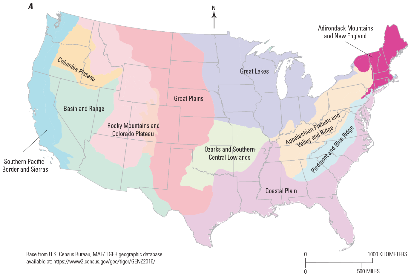
Maps showing physiographic provinces in (A) the conterminous United States (modified from Fenneman, 1970), and (B, following page) the Adirondack Mountains (Adirondacks), St. Lawrence and Champlain Valleys, and New England provinces.
The oldest bedrock (circa 1.4–0.9 Ga, giga annum, or billion years ago) is underlain by highly deformed crystalline metamorphic and igneous basement rocks of the Grenville province exposed in massifs of the Adirondack Mountains, Green Mountains, Berkshire Hills (or Berkshires), and Housatonic and Hudson Highlands (as in Walsh and others, 2004 and Ratcliffe and others, 2011). Neoproterozoic to Paleozoic metamorphic rocks of different terrane affinities and sedimentary rocks derived from the Appalachian Highlands (Hibbard and others, 2006) underlie the New England, Valley and Ridge, Appalachian Plateau, and St. Lawrence Valley provinces of Fenneman (1970).
Multiple orogenic events from the Mesoproterozoic to the Late Paleozoic deformed the bedrock of the Appalachian Mountains, which extends from Georgia to Maine and into Canada, and once extended to the United Kingdom, Western Europe, and Western Africa (as explained in Murphy and others, 2010, and van Staal and others, 2012). Middle to Late Paleozoic plutonic rocks are widespread, and Mesozoic rift basins and magmatic rocks are related to the formation of the Atlantic Basin and mantle plumes (Eby, 1987; Foland and Allen, 1991). The Appalachian Highlands disappear beneath the Cenozoic sedimentary rocks and unconsolidated deposits of the Atlantic Coastal Plain, which, in the Northeast region, occur only in coastal southern New York and southern New England. Excepting a small area of southwestern New York along the Pennsylvania border (Soller, 1993; Crowl and Sevon, 2002), the entire Northeast region was buried by Pleistocene continental ice sheets, the last of which created the terminal deposits from Long Island to Cape Cod during Wisconsinan glaciation (Stone and others, 2005).
Status of Geologic, Topographic, and Geophysical Mapping
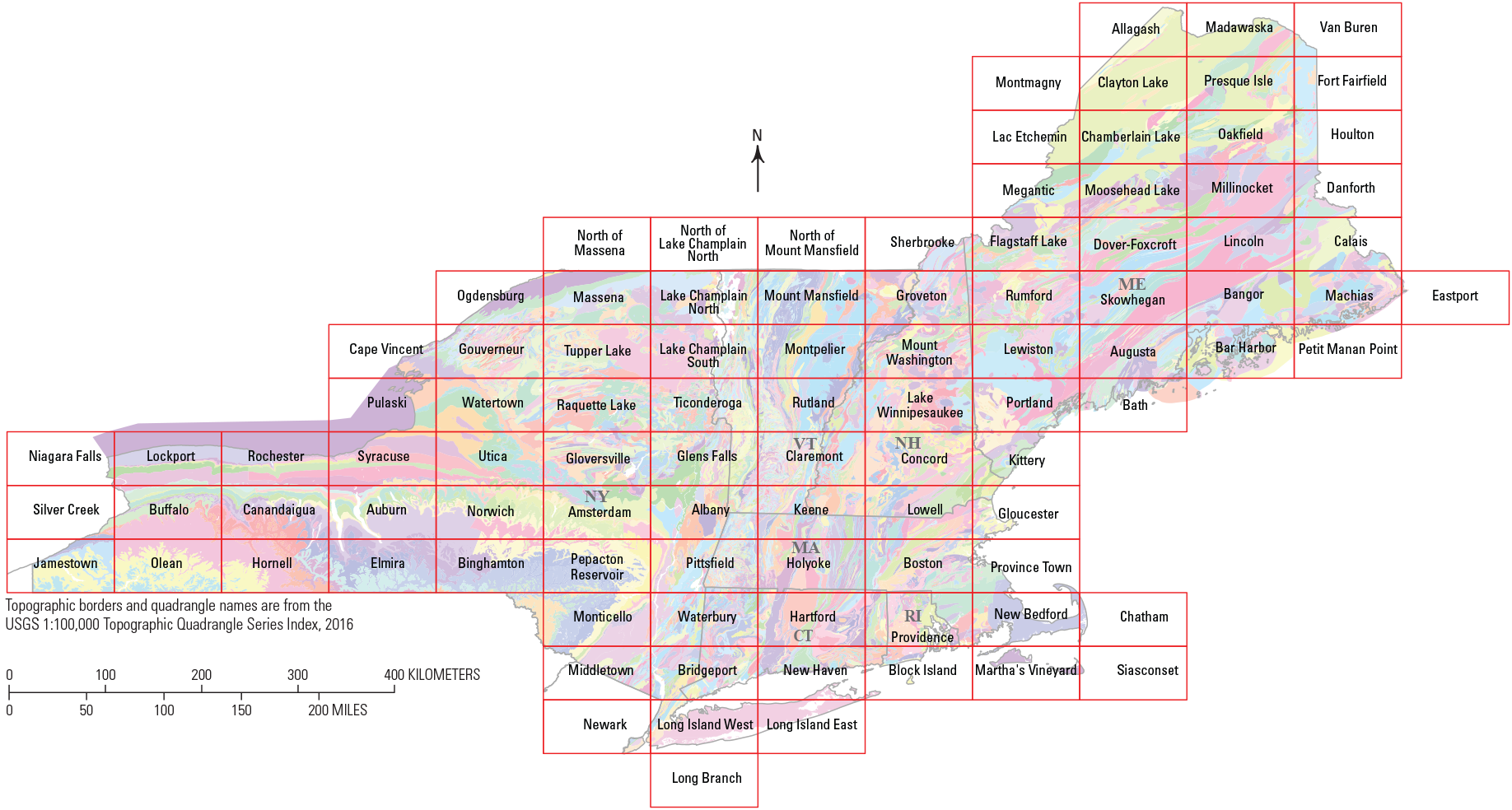
Over the last two decades, geologic mapping in the Northeast region focused on framework mapping at the scale most relevant to societal applications (1:24,000, as discussed in Bhagwat and Ipe, 2000; Fortier and others, 2019; and New England States Geologic Mapping Coalition [NESGMC], 2021). This is especially true for forested terrain underlain by the complex geology of the Northeast region. Map compilations at 1:100,000-scale are the current standard for synthesizing the detailed bedrock mapping of the region (Ratcliffe and others, 2011; Hussey and others, 2016). Map compilations at 1:24,000- to 1:125,00-scale are the current standard for synthesizing detailed surficial mapping in the region (see Stone and others, 2005, 2018).
These map compilations provide multiple benefits, such as improving upon the geologic framework mapping for a region or State, solving edge-match problems, superseding maps that are decades old, providing new maps that are more detailed than older maps (1:250,00 to 1:500,000), providing maps widely used in regional- and national-scale studies, and creating significant educational value. In many cases, regional syntheses were made possible by 1:24,000-scale mapping (see Cobb, 2002, and Ratcliffe and others, 2011).
The continued acquisition of new data from field observations is a requirement for any geologic mapping program, and the continuation of the practice has clear societal and economic value (Bernknopf and others, 1993; Bhagwat and Ipe, 2000; Cobb, 2002; Thomas, 2004; Hornberger and others, 2006; Häggquist and Söderholm, 2015; Indiana University, 2017). For this reason, it is the consensus of the working group that detailed mapping remains a crucial component of future work in the region.
Synopsis of Recently Sponsored National Cooperative Geologic Mapping Program Science and Mapping
For the last two decades, NCGMP-supported research in the Northeast region included 1:24,000- to 1:125,000-scale bedrock and surficial map products and framework geochronologic and hydrogeologic studies. Recent FEDMAP-supported projects in the Northeast region are listed below. Maps, reports, and data developed during these projects were often in direct cooperation with State geological surveys through STATEMAP9 (figs. 3 and 4) and provide a catalyst for future work in the region.
STATEMAP establishes the geologic framework of areas vital to the economic, social, or scientific welfare of individual States (USGS, 2018b).
The bedrock mapping projects include—
-
• 1998–2005, “Bedrock Regional Aquifer Systematics Studies,” project leaders, T.R. Armstrong, W.C. Burton, and G.J. Walsh.
-
• 2005–2010, “Geologic Mapping and Hydrogeology of Crystalline Rocks,” project leader, G.J. Walsh.
-
• 2010–2015, “Northern Appalachian Bedrock Mapping,” project leader, G.J. Walsh.
-
• 2015–2022, “Northeast Bedrock Mapping,” project leader, G.J. Walsh.
Surficial and bedrock mapping projects include—
-
• 2022–present, “Glaciated Regions,” project leader, C.S. Swezey
-
• 2018–2022, “Great Lakes Geologic Mapping,” project leader C.S. Swezey
-
• 2013–2018, “Quaternary Glacial Stratigraphic Framework,” project leader, B.D. Stone.
-
• 2003–2012, “Glacial Aquifer Systems Stratigraphy,” project leaders, J.R. Stone and B.D. Stone.
-
• 2007–2022, Quaternary Stratigraphic Framework of Massachusetts and part of southern Michigan, project leader, B.D. Stone.
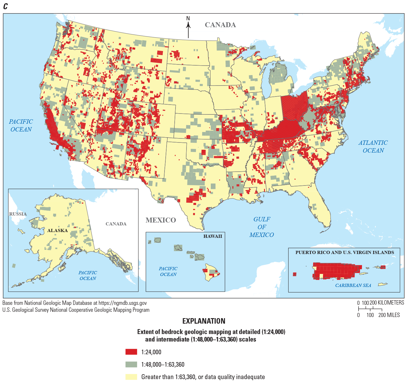
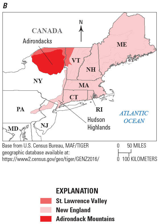
Index maps of the Northeast region of the United States. A. Map showing the year of publication of the State bedrock and surficial geologic maps, 1951–2011 (Goldthwait and others, 1951; Fisher and others, 1970; Stewart and MacClintock, 1970; Berg and others, 1980; Zen and others, 1983; Osberg and others, 1985; Rodgers, 1985; Thompson and Borns, 1985; Cadwell and others, 1991; Hermes and others, 1994; Drake and others, 1996; Lyons and others, 1997; Owens and others, 1999; Newell and others, 2000; Stone and others, 2002, 2005; Ratcliffe and others, 2011; Stone and others, 2018). In Massachusetts, a surficial materials map database is published (Stone and others, 2018), and a Quaternary map is being developed. B. Map showing the status of coverage of undifferentiated bedrock or surficial geologic maps published at 1:24,000- and 1:100,00-scale, provided by the National Cooperative Geologic Mapping Program in March 2018. Note the lack of 1:24,000-scale maps in the Hudson Highlands, the Adirondack Mountains, and northern Maine. C. (following page) Index map of bedrock geologic mapping in the United States showing detailed (1:24,000-scale) and intermediate scale (1:48,00- to 1:63,360-scale) maps deemed most useful (Fortier and others, 2019). n.a., not available.
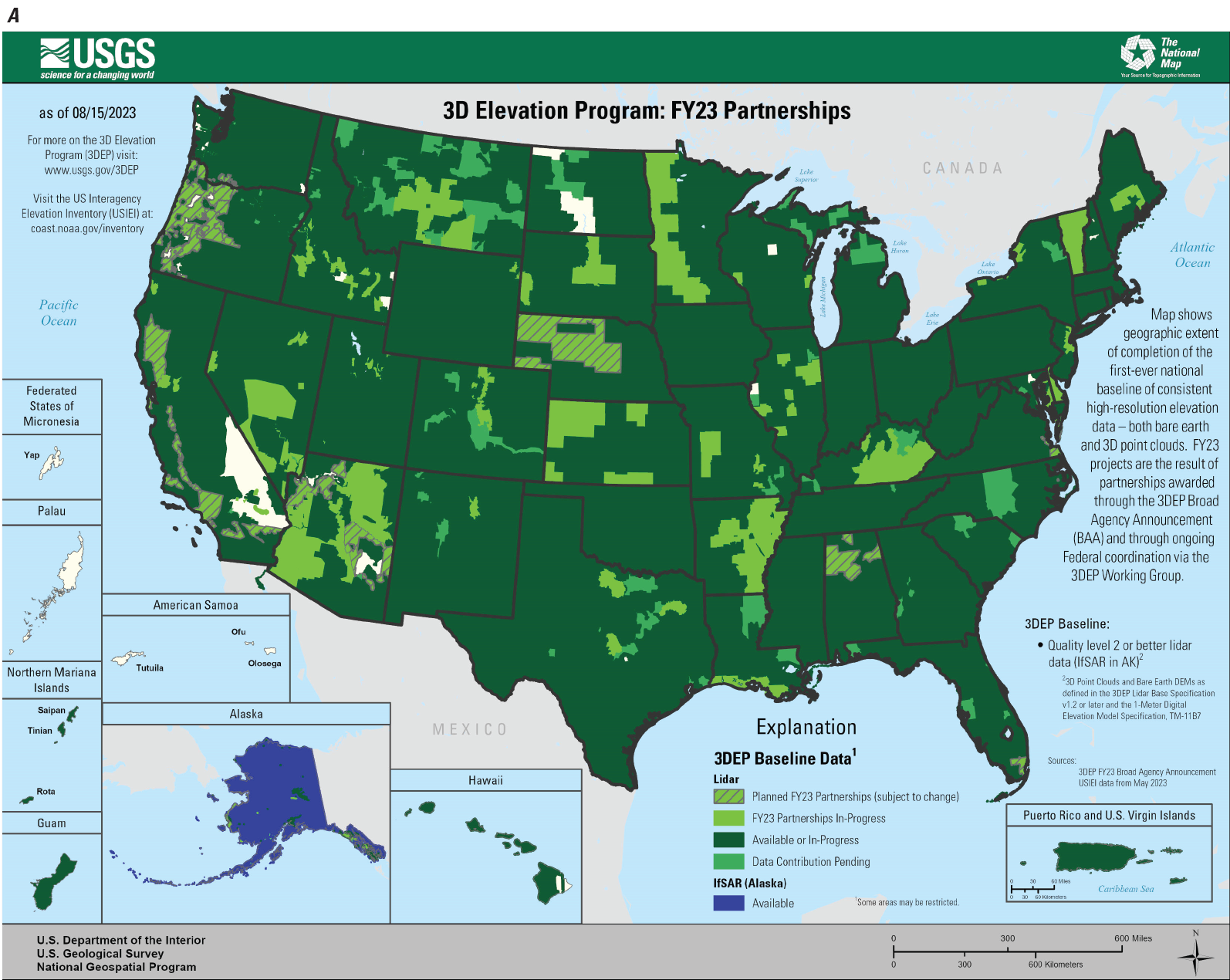
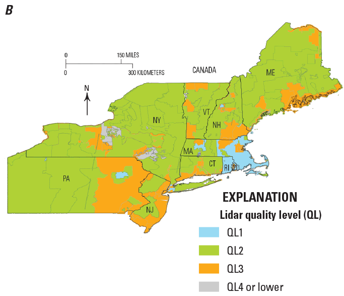
Map screenshot and map showing the status of light detection and ranging (lidar) mapping in the United States. A, Screenshot showing lidar coverage as of February 28, 2023 (U.S. Geological Survey, 2023). B, (following page) Map of the Northeast region of the United States showing the distribution and quality level of available lidar data—lidar quality levels QL1–QL4 (and below)—as of February 2, 2023 (U.S. Interagency Elevation Inventory, 2023).
Status of Geologic Mapping
In the Northeast region, statewide geologic maps of bedrock and surficial geology range from 1:100,000- to 1:500,000-scale and were published from 1951 to 2011 (fig. 3, and the “References Cited” section). Cooperative work between FEDMAP and the State of Massachusetts is nearing completion for a 1:100,000- to 1:125,000-scale statewide Quaternary map, and work has been completed on a map and database of surficial materials at 1:24,000-scale data (for example, Stone and others, 2018). The USGS is cooperating with the newly formed New England States Geologic Mapping Coalition (NESGMC) to meet future geologic mapping goals. This coalition of the six State geological surveys in New England signed a formal charter in April 2021 that seeks to “advance the understanding of the common characteristics of the crystalline bedrock and three-dimensional distribution of the glacial, periglacial, and post-glacial deposits underlying New England” (NESGMC, 2021).
In the last two decades, NCGMP-sponsored science and mapping has occurred in all States in the Northeast region with only limited mapping in Rhode Island. Limited FEDMAP bedrock mapping was completed over the Massachusetts-Rhode Island border along the Worcester-Providence Turnpike in northern Rhode Island (Walsh, 2014). FEDMAP is currently compiling a surficial materials map of Rhode Island (DiGiacomo-Cohen, 2023).
Status of Topographic Mapping
The USGS 7.5-minute series topographic quadrangles at 1:24,000-scale exist for the entire Northeast region. Most topographic maps have been revised within the last 30 years. Digital topographic data now exist for the entire area, at different levels of quality (fig. 4). The availability of light detection and ranging (lidar) data is rapidly expanding to cover the eastern United States. As of February 2023, the entire Northeast region is covered by lidar mapping. Data gaps from as recently as 2020 no longer exist, and even the most remote areas of the region in the western Adirondack Mountains and northern Maine now have lidar coverage (fig. 4).
Status of Geophysical Surveys
In the northeastern United States, historical mineralization is well-known where bedrock is exposed. Thorium, rare earth elements (REEs), titanium, and graphite occur in the Adirondack Mountains of New York and are considered a priority area for research and assessment of critical minerals potential (Schulz and others, 2017; Van Gosen and others, 2019; Hammarstrom and Dicken, 2019). Bedrock geologic mapping in the Adirondack Mountains by FEDMAP, STATEMAP, and EDMAP10 has advanced over the last eight years and represents the first modern 1:24,000-scale mapping in the area in decades (Walsh and others, 2022). FEDMAP activities in the Adirondack Mountains have been coordinated with STATEMAP and the Mineral Resources Program (MRP). The NCGMP and the MRP have cooperatively funded research in the Adirondack Mountains. In New England, beryllium occurs in New Hampshire and gallium, lithium, cobalt, and manganese occur in Maine (Schulz and others, 2017). Maine is currently the most active northeast state in the new USGS Earth Mapping Resources Initiative (Earth MRI) program (see Hammarstrom and others, 2020 and USGS, 2021), and coordination of the complementary mapping programs of the MRP and the NCGMP can provide opportunities for mapping in the Northeast region. The lack of modern, detailed geologic, topographic, and geophysical datasets impedes mineral exploration, and, conversely, the addition of these data can lead to significant investments from the private sector (Fortier and others, 2019).
EDMAP is a 1-year, mentor-guided program that teaches students geologic mapping techniques through field mapping (USGS, 2018a).
Little modern airborne geophysics data exist for the northeastern United States (fig. 5). The high-priority Adirondack Mountains region has the potential for critical mineral resource discovery but has only about 3 percent modern geophysical-data coverage at needed resolutions (Shah, 2016; Drenth and Grauch, 2019; Shah and others, 2021) (fig. 5) and even less 1:24,000-scale geologic map coverage (Walsh and others, 2018; Walsh and others, 2022). Recent airborne magnetic and radiometric geophysical data published on the eastern Adirondack Mountains (Shah, 2016; Shah and others, 2021) and northern Maine (Shah, 2022) represent the only modern geophysical data in the Northeast region, and new, high-quality airborne surveys can help the search for additional mineral deposits (Wang and others, 2023) and enhance geologic mapping. Historical airborne geophysical surveys in the Northeast region were conducted from the 1940s through the 1980s and subsequently digitized (Daniels and Snyder, 2004).
Few areas have geophysical data line-spacing resolutions higher than 0.5 kilometers (km), and most of the data are rank 4 or 5, which are the lowest quality rankings (fig. 5). Only recently were data collected at the resolution required for accurate, modern geologic mapping (as in the 0.25-km line spacing of Shah, 2016, 2022, and rank 1 data of Drenth and Grauch, 2019). New airborne surveys combined with geologic mapping, planned through the Earth MRI program and currently targeting the mineral potential in northern Maine, can address this regional need (Hammarstrom and others, 2020; USGS, 2021; Wang and others, 2023).
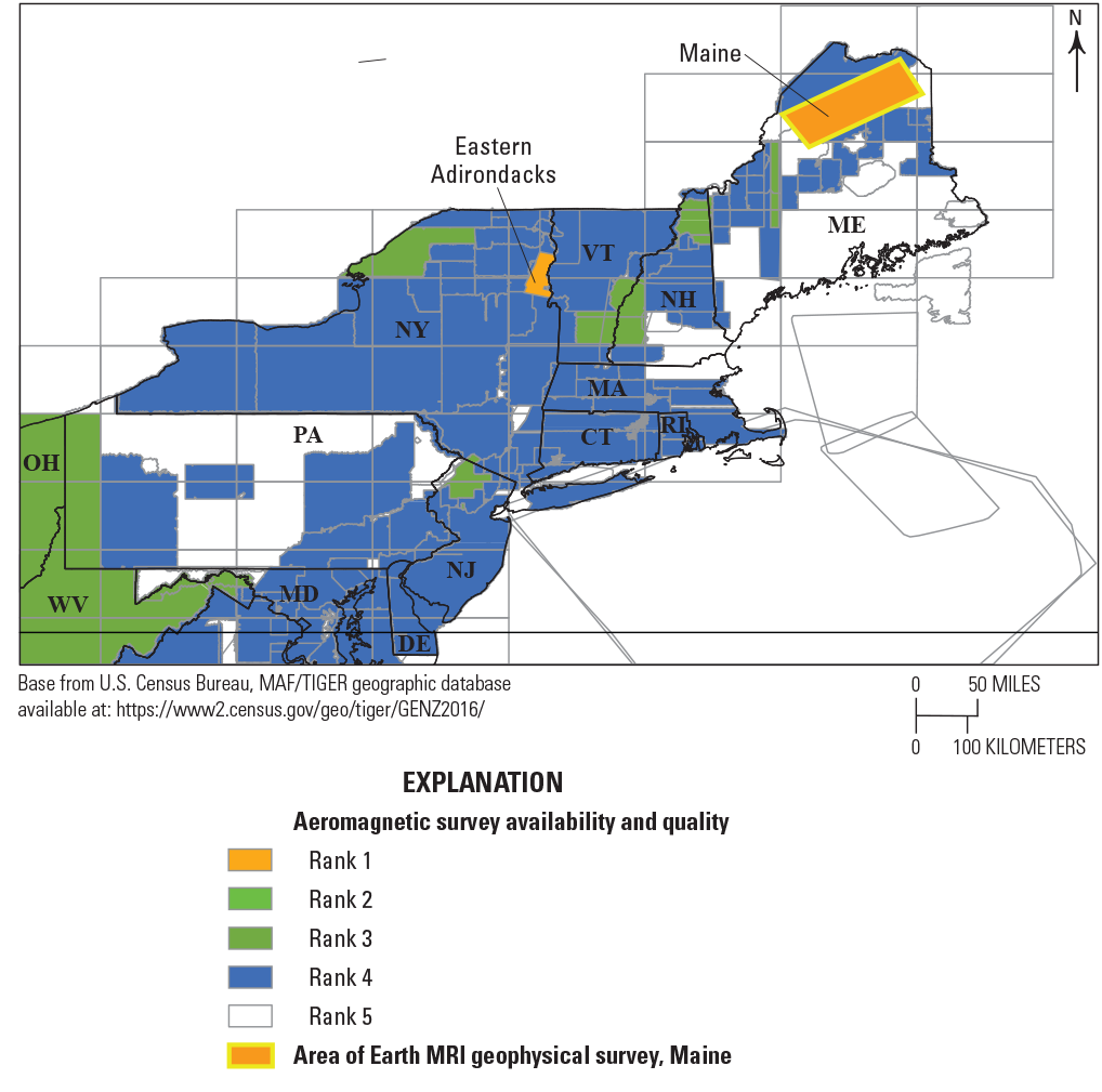
Map showing the status of airborne geophysical-survey coverage in the Northeast region from Drenth and Grauch (2019, fig. 3). Only the area of the Adirondack Mountains labelled “Eastern Adirondacks” and northern Maine have a flight line spacing of 0.25 kilometers and are deemed rank 1 quality and adequate by modern standards (Shah, 2016, 2022; Drenth and Grauch, 2019; Shah and others, 2021). Most of the Northeast region contains rank 4 or 5 data.
Scientific and Societal Relevance
A Congressional report by the Committee on Natural Resources addressing a bill submitted for reauthorization of The National Geologic Mapping Act of 1992 (Public Law 102–285 as amended, 106 Stat. 166) explained that the NCGMP is “designed to foster cooperation and coordination between the USGS and the State geologic surveys in generating modern, detailed, digitized, geologic maps in a cost effective and efficient manner” (U.S. Congress, House of Representatives Committee on Natural Resources, 2018).
New bedrock mapping is set to focus on areas that lack detail or modern maps. The new maps can contribute to framework studies, help characterize the distribution of mineral resources, and address questions about the tectonic evolution of mountain belts and the behavior of groundwater and groundwater contaminants in fractured rock. Research by the FEDMAP staff, States, and universities can integrate mapping, geochronology, petrology, geochemistry, geophysics, paleontology, and surficial geology in scientifically appropriate areas. The FEDMAP staff, together with State and university researchers, possess expertise in these areas; however, some States in the Northeast region may not have a full complement of experts. Modern, large-scale (1:24,000) bedrock geologic maps now include detailed fracture information for use in characterizing the recharge potential of bedrock lithologies and identifying potential pathways for groundwater and contaminant flow—such information is often lacking in older geologic maps.
“Top of rock,” which in this report refers to the surface between the regolith and the bedrock, is an important three-dimensional (3D) surface in geology, hydrology, hydrogeology, geomorphology, soil science, and engineering; however, specific data on this surface is nearly absent. Before the advent of lidar, even the top of rock at or near the land surface was difficult to accurately map in forested regions like the Northeast. A modern, high-resolution database of the bedrock surface-altitude is lacking. The FEDMAP and STATEMAP programs can develop an inventory of available data and develop a plan with the NESGMC for creating a model of the bedrock surface-altitude in New England.
The objectives include creating a seamless geographic information system (GIS) database and surface of the altitude of the top of rock beneath the unconsolidated glacial deposits, mapping the two-dimensional boundary between exposed bedrock and surficial deposits regionwide, and designing a robust spatial database for 3D modeling (Mabee and others, 2023). Long-term objectives include developing 3D models and depictions of the thickness of surficial deposits. The model of the top of rock can incorporate surficial geologic mapping, water-well and borehole data, subsurface geophysical data, and data on land-surface elevations.
Mapping projects target scientific research in tectonics, structural geology, igneous and metamorphic processes, mineral resource assessment, ore petrogenesis, geochronology, hydrogeology, hydrology, stratigraphy, glacial erosion and depositional processes, coastal processes, erosion, and geomorphology. Specific examples from ongoing work include tectonics and the origin of ancient volcanic arcs, precise geochronology in high-grade rocks, the origins of REEs in iron oxide apatite deposits in high-grade settings, the metasomatism of high-grade granite gneiss, the petrogenesis of lithium in pegmatites, the tectonics of Ordovician arc systems, and the geochronology of Acadian tectonics.
Mapping projects target societal goals addressing mineral and energy resources, karst, fractured-rock hydrogeology, water quality and availability, naturally occurring and anthropogenic contaminants, landslides, coastal and seismic hazards, construction aggregate, sulfidic rock and pyrrhotite hazards in aggregate, infrastructure, coastal and fluvial erosion, education, land-use planning, 3D mapping of the top of rock, and the synthesis of regional water-well and borehole data. Specific examples from ongoing FEDMAP program work include the assessment of rare earth elements (REEs) in iron oxide apatite deposits in abandoned iron mines, the mapping of mineral deposits with airborne geophysics, and determining the precise location of abandoned-mine lands with lidar.
A few examples from recent and ongoing FEDMAP program research include—
-
• tectonics and the geochronology of ancient volcanic arcs (Valley and others, 2019; Walsh and others, 2021);
-
• reactions and timing in ductile shear zones (McAleer and others, 2017; Regan and others, 2019);
-
• the use of integrated mapping, lidar, and geophysics in searching for REE potential in abandoned magnetite mines in the eastern Adirondack Mountains (Walsh and others, 2018; 2020a; Taylor and others, 2019; Shah and others, 2021; Walsh and others, 2022);
-
• the evaluation of fractured-rock contamination due to explosives used in road construction (Degnan and others, 2016);
-
• mapping the top of rock in New England (DiGiacomo-Cohen and others, 2020; Mabee and others, 2023);
-
• a geologic map of Mount Ascutney, Vermont’s most famous volcano (Walsh and others, 2020b);
-
• applying high-precision U-Pb geochronology in granulite facies rocks (Aleinikoff and others, 2021);
-
• mapping glacial and postglacial deposits using lidar (Stone and others, 2018); and
-
• mapping infrastructure in abandoned mine lands (Walsh and Walsh, 2023).
A few examples from recent and ongoing STATEMAP research include—
-
• nitrate contamination in fractured rock aquifers, Vermont (Kim and others, 2010, 2016);
-
• framework geologic mapping of volcanic massive sulfide deposits, Maine (Wang, 2021);
-
• framework bedrock mapping in the Connecticut River Valley, New Hampshire (Thompson, 2016);
-
• mapping the geology of historic parks, Connecticut (Moritz and others, 2019);
-
• mapping the Neoproterozoic Boston Basin, Massachusetts (Thompson, 2017); and
-
• mapping the surficial geology of Cayuga County, New York (N.Y.) (Kozlowski and others, 2018).
Scientific Objectives
Scientific research directly associated with geologic mapping that is funded by the NCGMP and its many cooperators is an essential part of the process that delivers geologic maps that meet the primary national goal of research and data characterization of the Earth (Bristol and others, 2013). Research and mapping help achieve the USGS strategic science goals (Gundersen and others, 2011) summarized below:
-
• Goal 1—Characterize and interpret the geologic framework of the Earth.
-
• Goal 2—Understand surface processes and their effects on the ecosystem.
-
• Goal 3—Understand and quantify the availability of Earth’s natural resources.
-
• Goal 4—Increase resilience to hazards.
-
• Goal 5—Apply advanced technology and best practices.
-
• Goal 6—Develop a flexible and diverse workforce for the future.
The overall scientific objectives of geologic mapping in the Northeast region aim to improve our understanding of the geologic framework and tectonic evolution of Mesoproterozoic to Paleozoic terranes and Mesozoic basins and the glacial stratigraphic framework related to Pleistocene glaciation.
The societal relevance of the scientific objectives includes the study of tectonics and seismic hazards in the Hudson Highlands (as in Ratcliffe, 1992); critical minerals in the Adirondack and Appalachian Mountains; landslides and per- and polyfluoroalkyl substances (PFAS) contamination in fractured bedrock in Vermont; landslides and river evulsion in New Hampshire; coastal hazards, sea-level rise, and groundwater and aggregate availability in Massachusetts; naturally occurring radionuclides in well water and pyrrhotite-bearing concrete aggregate in Connecticut and Massachusetts, and mineral resources and coastal hazards in Maine.
Since 2015, FEDMAP program activities in the Adirondack Mountains have been operating a prototype of the Earth MRI program as a result of the combined efforts of the USGS Florence Bascom Geoscience Center (Reston, Va.) and the USGS Geology, Geophysics, and Geochemistry Science Center (Lakewood, Colo.), in cooperation with the New York State Geological Survey. Scientific objectives include the tectonics and geochronology of granulite facies rocks, ore petrogenesis of iron oxide apatite deposits, and related REE petrogenesis and metasomatism in high-grade rocks. Future opportunities exist in the petrogenesis of volcanic massive sulfide deposits in northern Maine where Earth MRI-funded research is currently coordinated with new airborne geophysics and STATEMAP program geologic mapping (Wang and others, 2023). Additional Earth MRI and NCGMP coordinated research opportunities exist in critical minerals associated with pegmatites.
Geologic Mapping Objectives
Phase 1 Geologic Mapping Objectives
The Phase 1 objectives are threefold: (1) to produce detailed, high-quality 1:24,000-scale bedrock geologic maps that improve our understanding of crystalline bedrock in the Northeast region and define the geospatial infrastructure needed for future compilations and regional syntheses, (2) to complete the Quaternary geologic map of Massachusetts, and (3) to begin assembling data to assemble a surface model of the top of rock for New England. FEDMAP program activities can be coordinated with STATEMAP program investigations at State geological surveys and with USGS activities such as the Florence Bascom Geoscience Center (FBGC), the Geology, Geophysics, and Geochemistry Science Center (GGGSC), the MRP, and the Earth MRI program. Mapping can also be coordinated with hydrogeologic investigations by the Water Resources Mission Area (WMA) and cooperating State agencies to maximize the scientific and societal impact of the new research. Synergistic activities by the States (to assist with meeting the objectives) include the acquisition of grants from the WMA Water-Use Data and Research Program, Federal Emergency Management Agency Hazard Mitigation Grant Program, Earth MRI program, and State highway departments.
The 1:24,000-scale bedrock mapping and synthesis in the Adirondack Mountains includes the Champlain Valley in southern Essex County, N.Y., and adjacent Vermont. Framework geologic mapping is tied to critical minerals in Mesoproterozoic rocks and stratigraphic problems in Paleozoic rocks across state borders. Collaborative research between the USGS, the New York State Geological Survey, the University of Massachusetts Amherst, the National Science Foundation, and student researchers has focused on the tectonic, geochronologic, and metamorphic evolution of the Adirondack Mountains with emphasis on iron ore petrogenesis, REE-bearing minerals, and metasomatism in high grade rocks.
The 1:24,000-scale bedrock mapping and 1:50,000-scale synthesis in the Hudson Highlands of New York, with an emphasis on Putnam County, N.Y., and adjacent Connecticut, are emeritus-related research tied to the completion of about ten quadrangles. The 1:50,000-scale mapping is helpful for the compilation of work completed at the 1:24,000-scale because virtually all of the details can be shown on the smaller scale maps. New compilations at the 1:100,000-scale, or smaller, require a simplification of the more detailed mapping, in some locations, to produce a legible product that meets cartographic standards.
The 1:24,000-scale bedrock mapping in Connecticut, Vermont, New Hampshire, and Maine requires collaborative tectonics and geochronology research with the State geological surveys and universities. Planned cooperative research includes investigating natural and anthropogenic contaminants in drinking water and mineral resources of pegmatites.
Phase 1 plans involve assembling a database for development of a 3D model of the top of rock in New England. A cooperative research project among the NESGMC, the New England Water Science Center, and the NGMDB intends to produce a national database of boreholes (see Medalie and others, 2021). Key datasets in New England include (1) surficial geology, (2) borehole databases showing depth to bedrock, and (3) altitude of land surface (lidar and 10-meter digital elevation models [DEMs]). Subsurface geophysical datasets are limited but can be useful in some areas. The horizontal-to-vertical spectral ratio seismic method can fill data gaps and be applied to test models in crucial areas. Researchers can contribute to the NCGMP 3D Working Group and evaluate potential 3D modeling software and receive training. Algorithms can be developed for feature extraction of the bedrock-overburden interface from new lidar and older DEMs. Massachusetts is developing a statewide model to guide future top-of-rock mapping in the region (Mabee and others, 2023).
An ongoing FEDMAP-STATEMAP program partnership includes completion of the 1:100,000-scale compilation map of the Quaternary geology of Massachusetts. This work stems from completion of a statewide 1:24,000-scale database of surficial materials (Stone and others, 2018) in cooperation with activities in the Great Lakes region.
Additional Phase 1 objectives include—
-
• continued contributions to the Earth MRI Working Group;
-
• cooperative research with the NGMDB for assembling a national database of geochronology, a national borehole database, and improving regional stratigraphic correlations and the North American Stratigraphic Code;
-
• cooperative research with the NGMDB and the NESGMC to ensure accurate regional-scale compilations and resolve cross-border stratigraphic problems; and
-
• continued testing and development of digital mapping platforms, rugged field equipment, and integrated methods for facilitating field data collection and expediting the completion of geologic maps and databases. Results have been obtained in recent years using Apple iPad tablet computers and Bluetooth Global Positioning System receivers running the “Fieldmove” application, and new products and services are continually developed and tested. Additionally, portable gamma radiation detectors, gamma ray spectrometers, and portable x-ray spectrometers are being tested and deployed to assist with the petrophysical characterization of rocks for mapping and critical mineral studies (Shah and others, 2019; Suarez and others, 2020).
Examples of anticipated Phase 1 objectives by the States include—
-
• 1:24,000-scale bedrock mapping in Connecticut, Maine, and New Hampshire;
-
• 1:24,000-scale surficial mapping in Maine, New Hampshire, and Vermont;
-
• 1:24,000-scale bedrock and surficial mapping completion in populated areas of Maine;
-
• 1:24,000-scale bedrock mapping to support revised tectonic and critical mineral assessments in northern and western Maine; and
-
• 1:24,000-scale surficial mapping in landslide risk areas posed by glacial-marine clay units in Maine.
Phase 2 Geologic Mapping Objectives
Phase 2 objectives involve greater compilation efforts and continued 1:24,000-scale mapping that targets “cornerstone” quadrangles to constrain the compilations. FEDMAP-STATEMAP program partnerships have the following objectives:
-
• 1:50,000-scale compilation and bedrock-synthesis mapping in Putnam County, N.Y.;
-
• 1:24,000- to 1:100,000-scale compilation of the surficial materials map of Rhode Island—this is the only State in the region without a published, statewide, peer-reviewed surficial geologic map (fig. 3A);
-
• 1:24,000-, 1:50,000-, and 1:100,000-scale compilation and bedrock-synthesis mapping in Connecticut;
-
• 1:100,000-scale compilation of the 3D model of the top-of-rock surface in New England, in cooperation with the NESGMC;
-
• Coordination between the FEDMAP program, the NESGMC, and the Great Lakes Mapping Coalition on a seamless 3D model of the top-of-rock surface for the glaciated regions of the north-central and northeastern United States.
Examples of anticipated Phase 2 STATEMAP program activities include the following:
-
• 1:100,000-scale compilation and synthesis mapping of the surficial geology of the Montpelier 30- × 60-minute quadrangle, Vermont;
-
• 1:100,000-scale compilation and synthesis mapping of surficial geology in the Concord and Lowell 30- × 60-minute quadrangles, New Hampshire;
-
• 1:50,000- and 1:100,000-scale compilation and synthesis mapping of bedrock and fracture characterization of the I–495 corridor of Massachusetts;
-
• 1:24,000-scale publication of legacy mapping around the Quabbin Reservoir and in the Shutesbury area, Massachusetts; and
-
• the potential acquisition of rank 1 airborne geophysics to resolve cross-border stratigraphic problems and identify sulfide-rich rocks that might contain pyrrhotite, especially in Massachusetts and Connecticut.
Phase 3 Geologic Mapping Objectives
Phase 3 objectives, although flexible due to unanticipated demands and future needs, are expected to involve greater compilation efforts and continued 1:24,000-scale mapping that targets “cornerstone” quadrangles to constrain the compilations. FEDMAP-STATEMAP program partnerships have the following objectives:
-
• 1:100,000-scale map compilation of a new bedrock geologic map of Connecticut;
-
• a 3D model of top of rock in New England, merged with data from New York and the Great Lakes region; and
-
• seamless 1:100,000-, 1:250,000-, and 1:500,000-scale map compilations of the bedrock and surficial geology for the New England region and Appalachian Mountains.
Needed Capabilities
A significant workforce challenge is the declining number of qualified bedrock and surficial geologic mappers. Training students has helped limit the decrease, and continued hiring actions can help to maintain and grow high levels of expertise in the field of geologic mapping. Workforce planning is “Goal 6” of Gundersen and others (2011) and continues to be important today in order to support geologic mapping at the State and Federal levels. This challenge applies to both the USGS and State surveys in the Northeast region, where staffing is limited.
Scientists and technical staff must be skilled in GIS and digital mapping techniques. Complex and evolving database models and digital standards require increased time commitments from qualified technical staff to complete GIS deliverables along with attendant metadata. Hiring junior-level staff could help to increase productivity. Engaging students through various hiring mechanisms or through collaborations with partners can support training and mentoring for future science and technical staff.
Successful efforts to map and model the Earth in 3D may require costly software, advanced computers, and highly specialized staff with skills in programming and computer science (see MacCormack, 2018). 3D mapping is a science priority for the USGS (Brock and others, 2021), even as resources and personnel are limited; this presents an ongoing challenge, and innovative solutions are required. Hiring staff with 3D mapping and modeling expertise is a potential goal, and the USGS Pathways program may help expand junior-level staff and student hires.
Geochronology is a critical tool for a geologic mapping program. An essential tool for geochronology is the Sensitive High Resolution Ion Microprobe (SHRIMP). The Sensitive High-Resolution Ion Microprobe with Reverse Geometry (SHRIMP–RG) is operated by the USGS and Stanford University and is over two decades old. Other nations have begun to lead the way in SHRIMP technology, thereby indicating acquisition and development of state-of-the-art geochronology facilities is an area of consideration for USGS long-range planning.
Contemporary airborne geophysical data at rank 1 resolution (Drenth and Grauch, 2019) can benefit current, accurate geologic mapping in conjunction with mineral and hazard assessments. Current high-resolution data are limited in the Northeast region (fig. 5).
Partners
The primary partners for geologic mapping projects in the Northeast region include the U.S. Geological Survey, the New England States Geologic Mapping Coalition, the State geological surveys, the Great Lakes Geologic Mapping Coalition (which includes New York), and various universities. Contacts at the State geological surveys are shown in alphabetical order, by State, in table 1.
Contributing financial partners to FEDMAP program activities include the National Science Foundation, the National Park Service, the USGS Coastal and Marine Hazards and Resources Program, the MRP, and the Toxic Substances Hydrology Program. In-kind work has been conducted with the New England Water Science Center and the U.S. Forest Service, and future possibilities for mapping may exist in the Green Mountain and White Mountain National Forests, including the Appalachian Trail. The FEDMAP program work in the Northeast has been managed by the USGS through the Florence Bascom Geoscience Center, in collaboration with the Geology, Geophysics, and Geochemistry Science Center and Geosciences and Environmental Change Science Center.
Examples of recent cooperative FEDMAP-STATEMAP program partnerships include:
-
• “Bedrock geologic map of Vermont” (Ratcliffe and others, 2011);
-
• “Surficial Materials of Massachusetts—A 1:24,000-Scale Geologic Map Database” (Stone and others, 2018); and
-
• “Quaternary Geologic Map of Connecticut and Long Island Sound Basin” (Stone and others, 2005).
Table 1.
State geological agency contacts and contact information, by State.[n.a., not available; URL, uniform resource locator]
| State | Organization | Contact | Contact information | Organization website URL |
|---|---|---|---|---|
| Connecticut | Connecticut Geological Survey | Meghan Seremet—State geologist and director; | Telephone: 860–424–3583 Email: [email protected] |
https://portal.ct.gov/DEEP/Geology/Geological- Survey |
| Margaret A. Thomas—State geologist and director (retired). | n.a. | |||
| Maine | Maine Geological Survey | Stephen Dickson—State geologist and director; | Telephone: 207–287–2801 Email: [email protected] |
https://www.maine.gov/dacf/mgs/index.shtml |
| Robert G. Marvinney—State geologist and director (retired). | n.a. | |||
| Massachusetts | Massachusetts Geological Survey | Stephen B. Mabee—State geologist and director. | Telephone: 413–545–4814 Email: [email protected] |
http://mgs.geo.umass.edu/ |
| New Hampshire | New Hampshire Geological Survey | Shane Csiki—State geologist and director; | Telephone: 603–271–2876 E-mail: [email protected] |
https://www.des.nh.gov/land/geology |
| Rick Chormann—State geologist and director (retired). | n.a. | |||
| New York | New York State Museum and New York State Geological Survey | Andrew Kozlowski—director of the New York State Geological Survey and State Geological Mapping Program. | Telephone: 518–486–2012 E-mail: [email protected] |
http://www.nysm.nysed.gov/research-collections/geology |
| Rhode Island | University of Rhode Island | Brian Savage—State geologist (acting), department chair and associate professor. | Telephone: 401–874–5392 Email: [email protected] |
https://web.uri.edu/geo/rhode-island-geological-survey/ |
| Vermont | Vermont Geological Survey | Ben DeJong—State geologist and director; | Telephone: 802–461–5235 Email: [email protected] |
https://dec.vermont.gov/geological-survey |
| Marjorie Gale—State geologist and director (retired); | n.a. | |||
| Jon Kim—geologist. | Telephone: 802–522–5401 E-mail: [email protected] |
Anticipated Geologic Mapping Outcomes
The following paragraphs explain the potential benefits that can result from implementation of the NCGMP’s strategic plan. Digital geologic maps and databases that incorporate comprehensive structure, fracture, geochemical, geochronological, stratigraphic, and top-of-rock data can help many organizations, including (1) the State geological surveys of New York and the six New England States; (2) USGS water science centers; (3) other Federal agencies, including the National Park Service, U.S. Forest Service, Federal Emergency Management Agency, Natural Resources Conservation Service, and the National Oceanic and Atmospheric Administration; (4) the Mineral Systems Project of the USGS Mineral Resources Program; (5) the Earth MRI program; (6) the geotechnical, environmental engineering, and mining industries; (7) State-level departments of transportation and environmental conservation; (8) regional planning agencies; and (9) universities and educators.
New research in upstate New York produced the first peer-reviewed 1:24,000-scale bedrock geologic map of the Adirondack Highlands (Walsh and others, 2022). One quadrangle map is published and more 7.5-minute quadrangle maps are nearing completion. These new maps provide unprecedented detail, demonstrate applications of lidar, accurately show the locations of abandoned mines, provide updates and revisions to the stratigraphic and tectonic framework of the Adirondack Mountains, and present data that constrain the timing of igneous, metamorphic, and ore-forming events. As cornerstone maps, they are expected to set the standard for future bedrock mapping in the Adirondack Mountains.
New high-precision geochronology research (Aleinikoff and others, 2021) refined nearly three decades of scientific research on the origin of Mesoproterozoic granite gneisses in the Adirondack Mountains and their role in tectonics and ore petrogenesis.
New research on ancient deformed and metamorphosed arc volcanic rocks established new framework constraints on the tectonic evolution of New England (Valley and others, 2019; Walsh and others, 2021).
New geochemical and geophysical research on abandoned iron mines has shown that REEs are more common, abundant, and widespread than previously known and that waste rock piles may present a potential resource (Taylor and others, 2019; Shah and others, 2021).
Mount Ascutney is Vermont's most famous volcano and the place where early ideas for granite emplacement were first developed by Reginald Daly (1903). The new bedrock geologic map of Mount Ascutney (Walsh and others, 2020b) serves as an educational tool and resource guide and provides the scientific framework for the bedrock geology of the Connecticut Valley. The Mount Ascutney State Park and the Saint-Gaudens National Historical Park use the map and a guidebook article (Walsh and others, 2019) to educate and inform visitors about this iconic mountain.
References Cited
Aleinikoff, J.N., Walsh, G.J., and McAleer, R.J., 2021, New interpretations of the ages and origins of the Hawkeye Granite Gneiss and Lyon Mountain Granite Gneiss, Adirondack Mountains, NY—Implications for the nature and timing of Mesoproterozoic plutonism, metamorphism, and deformation: Precambrian Research, v. 358, article no. 106112, 37 p., accessed April 11, 2023, at https://doi.org/10.1016/j.precamres.2021.106112.
Berg, T.M., Edmunds, W.E., Geyer, A.R., Glover, A.D., Hoskins, D.M., MacLachlan, D.B., Root, S.I., Sevon, W.D., and Socolow, A.A., 1980, Geologic map of Pennsylvania (2nd ed.): Pennsylvania Geological Survey, Map 1, scale 1:250,000. [Also available at https://ngmdb.usgs.gov/Prodesc/proddesc_34341.htm.]
Bernknopf, R.L., Brookshire, D.S., Soller, D.R., Mckee, M.J., Sutter, J.F., Matti, J.C., and Campbell, R.H., 1993, Societal value of geologic maps: U.S. Geological Survey Circular 1111, 60 p., accessed April 11, 2023, at https://doi.org/10.3133/cir1111.
Bhagwat, S.B., and Ipe, V.C., 2000, The economic benefits of detailed geologic mapping to Kentucky: Illinois State Geological Survey Special Report 3, 39 p. [Also available at https://hdl.handle.net/2142/45219.]
Bristol, R.S., Euliss, N.H., Jr., Booth, N.L., Burkardt, N., Diffendorfer, J.E., Gesch, D.B., McCallum, B.E., Miller, D.M., Morman, S.A., Poore, B.S., Signell, R.P., and Viger, R.J., 2013, U.S. Geological Survey core science systems strategy—Characterizing, synthesizing, and understanding the critical zone through a modular science framework: U.S. Geological Survey Circular 1383–B, 33 p., accessed April 11, 2023, at https://doi.org/10.3133/cir1383B
Brock, J., Berry, K., Faulds, J., Berg, R., House, K., Marketti, M., McPhee, D., Schmidt, K., Schmitt, J., Soller, D., Spears, D., Thompson, R., Thorleifson, H., and Walsh, G., 2021, Renewing the National Cooperative Geologic Mapping Program as the Nation’s authoritative source for modern geologic knowledge: U.S. Geological Survey Open-File Report 2021–1013, 10 p., accessed April 11, 2023, at https://doi.org/10.3133/ofr20211013.
Cadwell, D.H., Connally, G.G., Dineen, R.J., Fleisher, P.J., Franzi, D.A., Fuller, M.L., Gurrieri, J.T., Haselton, G.M., Kelley, G.C., LaFleur, R.G., Muller, E.H., Pair, D.L., and Rich, J.L., Sirkin, L., Street, J.S., Young, R.A., and Wiles, G.C., 1991, Surficial geologic map of New York: New York State Museum, Map and Chart Series 40, 5 sheets, scale 1:250,000. [Also available at https://www.nysm.nysed.gov/publications/map-chart-series.]
Cobb, J.C., 2002, The value of geologic maps and the need for digitally vectorized data in Soller, D.R., ed., Digital Mapping Techniques '02—Workshop proceedings—May 19–22, 2002, Salt Lake City, Utah: U.S. Geological Survey Open-File Report 02–370, p. 3–6, accessed April 11, 2023, at https://doi.org/10.3133/ofr02370.
Daly, R.A., 1903, Geology of Ascutney Mountain: U.S. Geological Survey Bulletin 209, 122 p., accessed July 31, 2023, at https://doi.org/10.3133/b209.
Daniels, D.L., and Snyder, S.L., 2004, New England States aeromagnetic and gravity maps and data—A web site for distribution of data: U.S. Geological Survey Open-File Report 2004–1258, accessed April 11, 2023, at https://doi.org/10.3133/ofr20041258.
Degnan, J.R., Böhlke, J.K., Pelham, K., Langlais, D.M., and Walsh, G.J., 2016, Identification of groundwater nitrate contamination from explosives used in road construction—Isotopic, chemical, and hydrologic evidence: Environmental Science & Technology, v. 50, no. 2, p. 593–603, accessed April 11, 2023, at https://doi.org/10.1021/acs.est.5b03671.
DiGiacomo-Cohen, M., 2023, 37–14–A preliminary surficial materials map of Rhode Island [abs.]: Geological Society of America Abstracts with Programs, v. 55, no. 2, accessed April 11, 2023, at https://doi.org/10.1130/abs/2023SE-385306.
DiGiacomo-Cohen, M., Walsh, G.J., Chormann, F.H., Jr., Engelhart, S.E., Gale, M.H., Mabee, S.B., Marvinney, R.G., and Thomas, M.A., 2020, An introduction to the New England Top of Rock (NE TOR) project: Geological Society of America Abstracts with Programs, v. 52, no. 2, accessed April 11, 2023, at https://doi.org/10.1130/abs/2020SE-344734.
Drake, A.A., Jr., Volkert, R.A., Monteverde, D.H., Herman, G.C., Houghton, H.F., Parker, R.A., and Dalton, R.F., 1996, Bedrock geologic map of northern New Jersey: U.S. Geological Survey Miscellaneous Geologic Investigations Map I–2540–A, 2 sheets, scale 1:100,000. [Also available at https://ngmdb.usgs.gov/Prodesc/proddesc_13025.htm.]
Drenth, B.J., and Grauch, V.J.S., 2019, Finding the gaps in America’s magnetic maps: Eos, v. 100, accessed April 11, 2023, at https://doi.org/10.1029/2019EO120449.
Eby, N., 1987, The Monteregian Hills and White Mountain alkaline igneous provinces, eastern North America: Geological Society, London, Special Publication, v. 30, no. 1, p. 433–447, accessed April 11, 2023, at https://doi.org/10.1144/GSL.SP.1987.030.01.21.
Fenneman, N.M., 1970, Physical divisions, in U.S. Geological Survey and Gerlach, A.C., ed., The national atlas of the United States of America: Reston, Va., U.S. Geological Survey, p. 60. [Also available at https://hdl.loc.gov/loc.gmd/g3701gm.gct00013.]
Foland, K.A., and Allen, J.C., 1991, Magma sources for Mesozoic anorogenic granites of the White Mountain magma series, New England, USA: Contributions to Mineralogy and Petrology, v. 109, no. 2, p. 195–211, accessed April 11, 2023, at https://doi.org/10.1007/BF00306479.
Fortier, S.M., Hammarstrom, J.H., Ryker, S.J., Day, W.C., and Seal, R.R., 2019, USGS critical minerals review: Mining Engineering, v. 71, no. 5, p. 35–47, accessed April 11, 2023, at https://me.smenet.org/abstract.cfm?preview=1&articleID=8926&page=35.
Gundersen, L.C.S., Belnap, J., Goldhaber, M., Goldstein, A., Haeussler, P.J., Ingebritsen, S.E., Jones, J.W., Plumlee, G.S., Thieler, E.R., Thompson, R.S., and Back, J.M., 2011, Geology for a changing world 2010–2020—Implementing the U.S. Geological Survey science strategy: U.S. Geological Survey Circular 1369, 68 p., accessed April 11, 2023, at https://doi.org/10.3133/cir1369.
Häggquist, E., and Söderholm, P., 2015, The economic value of geological information—Synthesis and directions for future research: Resources Policy, v. 43, p. 91–100, accessed April 11, 2023, at https://doi.org/10.1016/j.resourpol.2014.11.001.
Hammarstrom, J.H., and Dicken, C.L., 2019, Focus areas for data acquisition for potential domestic sources of critical minerals—Rare earth elements, chap. A of U.S. Geological Survey, Focus areas for data acquisition for potential domestic sources of critical minerals: U.S. Geological Survey Open-File Report 2019–1023–A, 11 p, accessed April 11, 2023, at https://doi.org/10.3133/ofr20191023A.
Hammarstrom, J.M., Dicken, C.L., Day, W.C., Hofstra, A.H., Drenth, B.J., Shah, A.K., McCafferty, A.E., Woodruff, L.G., Foley, N.K., Ponce, D.A., Frost, T.P., and Stillings, L.L., 2020, Focus areas for data acquisition for potential domestic resources of 11 critical minerals in the conterminous United States, Hawaii, and Puerto Rico—Aluminum, cobalt, graphite, lithium, niobium, platinum-group elements, rare earth elements, tantalum, tin, titanium, and tungsten, chap. B of U.S. Geological Survey, Focus areas for data acquisition for potential domestic sources of critical minerals: U.S. Geological Survey Open-File Report 2019–1023–B, 67 p., accessed April 11, 2023, at https://doi.org/10.3133/ofr20191023B.
Hermes, O.D., Gromet, L.P., and Murray, D.P., 1994, Bedrock geologic map of Rhode Island: Rhode Island Geological Survey, Rhode Island Map Series 1, 1 sheet, scale 1:100,000. [Also available at https://ngmdb.usgs.gov/Prodesc/proddesc_19719.htm.]
Hibbard, J.P., van Staal, C.R., Rankin, D.W., and Williams, H., 2006, Lithotectonic map of the Appalachian orogen, Canada-United States of America: Geological Survey of Canada “A” Series Map 2096A, 2 sheets, scale 1:1,500,000, accessed April 11, 2023, at https://doi.org/10.4095/221912.
Hornberger, G.M., Jackson, K.J., Krishtalka, L., Pieper, F.V., Prescott, W.H., Williams, T.H.L., and Hunt, A., 2006, Review and guidance to the United States Geological Survey National Cooperative Geologic Mapping Program: [Washington, D.C.], American Association for the Advancement of Science, Research Competitiveness Service, November, 51 p., accessed April 11, 2023, at http://ngmdb.usgs.gov/Info/reports/AAAS_2006FinalReport.pdf.
Hussey, A.M., II, Bothner, W.A., and Thompson, P.J., 2016, Bedrock geology of the Kittery 1:100,000 quadrangle, Maine and New Hampshire (revised 2019): Maine Geological Survey Geologic Map 16–6, 1 sheet, scale 1:100,000, accessed April 11, 2023, at https://digitalmaine.com/mgs_maps/517/.
Indiana University, 2017, An economic impact analysis of the Indiana Geological Survey: [Bloomington, Ind.], Indiana University, prepared by School of public & environmental affairs, Capstone class 7933, V–600, 65 p., accessed April 11, 2023, at https://igws.indiana.edu/About/IGS_Economic_Impact_Analysis.pdf.
Kim, J., Comstock, J., Ryan, P., Heindel, C., and Koenigsberger, S., 2016, Denitrification and dilution along fracture flowpaths influence the recovery of a bedrock aquifer from nitrate contamination: Science of the Total Environment, v. 569–570, p. 450–468, accessed April 11, 2023, at https://doi.org/10.1016/j.scitotenv.2016.06.091.
Kim, J., Gale, M., McMillan, M., Zolkos, S., and Springston, G., 2010, Bedrock geologic map of the town of Craftsbury, Vermont: Vermont Geological Survey Open-File Report VG10–4, 3 sheets, scale 1:24,000.[Also available at https://dec.vermont.gov/sites/dec/files/geo/OpenFile/VG104CraftsburyRx.pdf .]
Kozlowski, A.L., Bird, B.C., Leone, J.R., and Backhaus, K.J., 2018, Surficial geology of Cayuga County, New York: The New York State Museum and Geological Survey, New York State Museum Map & Chart 104, 1 sheet, scale 1:100,000. [Also available at https://www.nysm.nysed.gov/file/4506.]
Langenheim, V.E., Graymer, R.W., Powell, R.E., Schmidt, K.M., and Sweetkind, D.S., 2021, Implementation plan for the southern Pacific Border and Sierra-Cascade Mountains provinces: U.S. Geological Survey Open-File Report 2021–1012, 11 p., accessed April 11, 2023, at https://doi.org/10.3133/ofr20211012.
Lyons, J.B., Bothner, W.A., Moench, R.H., and Thompson, J.B., Jr., 1997, Bedrock geologic map of New Hampshire: U.S. Geological Survey map, 2 sheets, scale 1:250,000. [Also available at https://doi.org/10.3133/70211051.]
Mabee, S.B., Duncan, C.C., Clement, W.P., and Stone, B.D., 2023, Update on Massachusetts’ contribution to the goals for a seamless, national 2d/3d geologic framework model for the United States: top of rock [abs.]: Geological Society of America Abstracts with Programs, v. 55, no. 2, accessed April 11, 2023, https://doi.org/10.1130/abs/2023se-385598.
MacCormack, K., 2018, 3D geological mapping—Mapping the geology of Alberta in 3D—Enhancing science-based decision making and communication of complex geoscience information to stakeholders, in Thorleifson, L.H., ed., Geologic Mapping Forum 2018 Abstracts, Minnesota Geological Survey Open File Report OFR18–01, p. 49–50, accessed April 11, 2023, at http://hdl.handle.net/11299/194852.
McAleer, R.M., Bish, D.L., Kunk, M.J., Sicard, K.R., Valley, P.M., Walsh, G.J., Wathen, B.A., and Wintsch, R.P., 2017, Reaction softening by dissolution-precipitation creep in a retrograde greenschist facies ductile shear zone, New Hampshire, USA: Journal of Metamorphic Geology, v. 35, no. 1, p. 95–119, accessed April 11, 2023, at https://doi.org/10.1111/jmg.12222.
Medalie, L., Johnson, J.W., Parker, M., Dinh, Y.V., Cartwright, M.D., Pritchard, J.A., Walsh, G.J., and DiGiacomo-Cohen, M., 2021, Data release for depth to bedrock from Connecticut Water Resources Bulletins: U.S. Geological Survey data release, accessed April 11, 2023, at https://doi.org/10.5066/P93A0BB9.
Merschat, A.J., Carter, M.W., and Piedmont and Blue Ridge Working Group, 2022, Implementation plan of the National Cooperative Geologic Mapping Program strategy—Appalachian Piedmont and Blue Ridge Provinces: U.S. Geological Survey Open-File Report 2022–1050, 24 p., accessed April 11, 2023, at https://doi.org/10.3133/ofr20221050.
Moritz, H., Devlin, W., Wintsch, R., Hillenbrand, I., and Kläng, Z., 2019, Bedrock geologic map of The Old Mine Park area, Trumbull, Connecticut (ver. 1.0): State Geological and Natural History Survey of Connecticut [CGNHS], Department of Energy and Environmental Protection CGNHS OF19–2, 1:1,600 scale, [Companion map to Geology & Mineralogy of the Old Mine Park area, Trumbull, Connecticut, Connecticut Geological and Natural History Survey Guidebook 11. Also available at https://portal.ct.gov/DEEP/Geology/Bedrock-Geologic-Map-of-Old-Mine-Park.]
Murphy, J.B., Keppie, J.D., Nance, R.D., and Dostal, J., 2010, Comparative evolution of the Iapetus and Rheic Oceans—A North America perspective: Gondwana Research, v. 17, nos. 2–3, p. 482–499, accessed April 11, 2023, at https://doi.org/10.1016/j.gr.2009.08.009.
New England States Geologic Mapping Coalition [NESGMC], 2021, Memorandum of Understanding for the New England States Geologic Mapping Coalition [Connecticut Geological and Natural History Survey, the Maine Geological Survey, the Massachusetts Geological Survey, the New Hampshire Geological Survey, the Rhode Island Geological Survey, and the Vermont Geological Survey]: NESGMC Memorandum of Understanding, 8 p., accessed July 31, 2023, at https://sos.nh.gov/media/5o2krorx/078-gc-agenda-042121.pdf. [Includes State of New Hampshire Department of Environmental Services cover letter.]
Newell, W.L., Powars, D.S., Owens, J.P., Stanford, S.D., and Stone, B.D., 2000, Surficial geologic map of central and southern New Jersey: U.S. Geological Survey Miscellaneous Investigations Series Map I–2540–D, 3 sheets, scale 1:100,000. [Also available at https://ngmdb.usgs.gov/Prodesc/proddesc_37331.htm.]
Osberg, P.H., Hussey, A.M., II, and Boone, G.M., eds., 1985, Bedrock geologic map of Maine: Maine Geological Survey map, 1 sheet, scale 1:500,000. [Also available at https://digitalmaine.com/mgs_maps/23/.]
Owens, J.P., Sugarman, P.J., Sohl, N.F., Parker, R.A., Houghton, H.F., Volkert, R.A., Drake, A.A., Jr., and Orndorff, R.C., 1999, Bedrock geologic map of central and southern New Jersey: U.S. Geological Survey Miscellaneous Investigations Series Map I–2540–B, 4 sheets, scale 1:100,000. [Also available at https://ngmdb.usgs.gov/Prodesc/proddesc_19458.htm.]
Ratcliffe, N.M., 1992, Bedrock geology and seismotectonics of the Oscawana Lake quadrangle, New York: U.S. Geological Survey Bulletin 1941, 38 p., 1 pl. [Also available at https://doi.org/10.3133/b1941.]
Ratcliffe, N.M., Stanley, R.S., Gale, M.H., Thompson, P.J., and Walsh, G.J., 2011, Bedrock geologic map of Vermont: U.S. Geological Survey Scientific Investigations Map 3184, 3 sheets, scale 1:100,000, accessed April 11, 2023, at https://pubs.usgs.gov/sim/3184/.
Regan, S.P., Walsh, G.J., Williams, M.L., Chiarenzelli, J.R., Toft, M., and McAleer, R., 2019, Syn-collisional exhumation of hot middle crust in the Adirondack Mountains (New York, USA)—Implications for extensional orogenesis in the southern Grenville Province: Geosphere, v. 15, no. 4, p. 1240–1261, accessed April 11, 2023, at https://doi.org/10.1130/GES02029.1.
Schulz, K.J., DeYoung, J.H., Jr., Seal, R.R., II, and Bradley, D.C., eds., 2017, Critical mineral resources of the United States—Economic and environmental geology and prospects for future supply, U.S. Geological Survey Professional Paper 1802, 797 p., accessed April 11, 2023, at https://doi.org/10.3133/pp1802.
Shah, A.K., 2016, Airborne Geophysical Surveys over the Eastern Adirondacks, New York State: U.S. Geological Survey data release, accessed April 11, 2023, at https://doi.org/10.5066/F72R3PT0.
Shah, A.K., 2022, Airborne magnetic and radiometric survey, Munsungun region in northern Maine, 2021: U.S. Geological Survey data release, accessed April 11, 2023, https://doi.org/10.5066/P97VUIJS.
Shah, A.K., Taylor, R.D., Walsh, G.J., and Phillips, J.D., 2021, Integrated geophysical imaging of rare earth element-bearing iron oxide-apatite deposits in the Eastern Adirondack Highlands, New York: Geophysics, v. 86, no. 1, p. B37–B54, accessed April 11, 2023, at https://doi.org/10.1190/geo2019-0783.1.
Shah, A.K., Walsh, G.J., Klein, A.J., and Suarez, K.A., 2019, Petrophysical data collected on outcrops and rock samples from the eastern Adirondack Highlands, New York: U.S. Geological Survey data release, accessed April 11, 2023, at https://doi.org/10.5066/P9E6P7S2.
Soller, D.R., 1993, Map showing the thickness and character of Quaternary sediments in the glaciated United States east of the Rocky Mountains—northeastern States, the Great Lakes, and parts of southern Ontario and the Atlantic offshore area (east of 80 degrees 31 minutes): U.S. Geological Survey Miscellaneous Investigations Series Map I–1970–A, 1 sheet, scale 1:1,000,000, accessed April 11, 2023, at https://doi.org/10.3133/i1970A.
Stewart, D.P., and MacClintock, P., 1970, Surficial geologic map of Vermont: Vermont Geological Survey, Department of Water Resources, Miscellaneous Map MISCMAP–02, 1 sheet, scale 1:250,000. [Also available at https://ngmdb.usgs.gov/Prodesc/proddesc_34628.htm.]
Stone, B.D., Stanford, S.D., and Witte, R.W., 2002, Surficial geologic map of northern New Jersey: U.S. Geological Survey, Miscellaneous Investigations Series Map I–2540–C, 3 sheets, scale 1:100,000. [Also available at https://ngmdb.usgs.gov/Prodesc/proddesc_52731.htm.]
Stone, J.R., Schafer, J.P., London, E.H., DiGiacomo-Cohen, M.L., Lewis, R.S., and Thompson, W.B., 2005, Quaternary geologic map of Connecticut and Long Island Sound Basin (ver. 1.0): U.S. Geological Survey Scientific Investigations Map 2784, 2 sheets, scale 1:125,000, 72-p. pamphlet, accessed April 11, 2023, at https://doi.org/10.3133/sim2784.
Stone, J.R., Stone, B.D., DiGiacomo-Cohen, M.L., and Mabee, S.B., comps., 2018, Surficial materials of Massachusetts—A 1:24,000-scale geologic map database: U.S. Geological Survey Scientific Investigations Map 3402, 189 sheets, scale 1:24,000, 58-p. pamphlet, accessed April 11, 2023, at https://doi.org/10.3133/sim3402.
Suarez, K., Walsh, G.J., Williams, M.L., Jercinovic, M.J., and Tjapkes, D.J., 2020, A field assessment of the gamma-ray spectrometer and portable XRF analyzer in determining potassium concentrations of metasomatized granite gneiss [abs.]: Geological Society of America Abstracts with Programs, v. 52, no. 2, accessed April 11, 2023, at https://doi.org/10.1130/abs/2020SE-344815.
Taylor, R.D., Shah, A.K., Walsh, G.J., and Taylor, C.D., 2019, Geochemistry and geophysics of iron oxide-apatite deposits and associated waste piles with implications for potential rare earth element resources from ore and historic mine waste in the eastern Adirondack Highlands, New York, USA: Economic Geology, v. 114, no. 8, p. 1569–1598, accessed April 11, 2023, at https://doi.org/10.5382/econgeo.4689.
Thomas, W.A., 2004, Meeting challenges with geologic maps: Alexandria, Va., American Geological Institute [AGI], AGI Environmental Awareness Series, v. 7, 65 p., accessed April 11, 2023, at https://www.americangeosciences.org/sites/default/files/Environment-mappingbook.pdf.
Thompson, M.D., 2017, Bedrock geologic map of the Newton 7.5’ quadrangle, Middlesex, Norfolk and Suffolk counties, Massachusetts: Massachusetts Geological Survey Geologic Map GM–17–01, 1 sheet, scale 1:24,000, accessed April 11, 2023, at https://mgs.geo.umass.edu/newton.
Thompson, P.J., 2016, Bedrock geologic map of the Lyme 7.5' quadrangle, New Hampshire: New Hampshire Geological Survey, NH Department of Environmental Services, Bedrock Geologic Map Open-File Series GEO–080–024000–BMOF, 1 sheet, scale 1:24,000. accessed April 11, 2023, at https://www.des.nh.gov/sites/g/files/ehbemt341/files/documents/2020-01/Geo-080-024000_BMOF_Lyme.pdf.
Thompson, W.B., and Borns, H.W., Jr., eds., 1985, Surficial geologic map of Maine: Maine Geological Survey, 1 sheet, scale 1:500,000. Maine Geological Survey Maps 15, accessed April 11, 2023, at https://digitalmaine.com/mgs_maps/15.
U.S. Congress, House of Representatives Committee on Natural Resources, 2018, National Geologic Mapping Act Reauthorization Act report [January 12, 2018, “To accompany H.R. 4033.”]: U.S. Congress, 115th, 2d session, House Report 115–515, 10 p., accessed July 6, 2023, at https://www.govinfo.gov/content/pkg/CRPT-115hrpt515/pdf/CRPT-115hrpt515.pdf.
U.S. Geological Survey [USGS], 2018a, National Cooperative Geologic Mapping Program—EDMAP: USGS website, accessed April 8, 2023, at https://www.usgs.gov/programs/national-cooperative-geologic-mapping-program/science/edmap-0.
U.S. Geological Survey [USGS], 2018b, National Cooperative Geologic Mapping Program—STATEMAP: USGS website, accessed April 8, 2023, at https://www.usgs.gov/programs/national-cooperative-geologic-mapping-program/science/statemap-0.
U.S. Geological Survey [USGS], 2021, Media alert—Flights above northern Maine to map geology: U.S. Geological Survey website, accessed September 17, 2021, at https://www.usgs.gov/news/media-alert-flights-above-northern-maine-map-geology.
U.S. Geological Survey [USGS], 2023, 3D Elevation Program FY23 Partnerships: U.S. Geological Survey website, accessed April 11, 2023, at https://www.usgs.gov/media/images/3d-elevation-program-fy23-partnerships.
U.S. Interagency Elevation Inventory [USIEI], 2023, USIEI web page: National Oceanic and Atmospheric Administration website, accessed February 2, 2023, at https://coast.noaa.gov/inventory.
Valley, P.M., Walsh, G.J., Merschat, A.J., and McAleer, R.J., 2019, Geochronology of the Oliverian Plutonic Suite and the Ammonoosuc Volcanics in the Bronson Hill arc—Western New Hampshire, USA: Geosphere, v. 16, no. 1, p. 1–29, accessed April 11, 2023, at https://doi.org/10.1130/GES02170.1.
Van Gosen, B.S., Verplanck, P.L., and Emsbo, P., 2019, Rare earth element mineral deposits in the United States (ver. 1.1, April 15, 2019): U.S. Geological Survey Circular 1454, 16 p., accessed April 11, 2023, at https://doi.org/10.3133/cir1454.
van Staal, C.R., Barr, S.M., and Murphy, J.B., 2012, Provenance and tectonic evolution of Ganderia—Constraints on the evolution of the Iapetus and Rheic oceans: Geology, v. 40, no. 11, p. 987–990, accessed April 11, 2023, at https://doi.org/10.1130/G33302.1.
Walsh, G.J., 2014, Bedrock geologic map of the Uxbridge quadrangle, Worcester County, Massachusetts, and Providence County, Rhode Island: U.S. Geological Survey Scientific Investigations Map 3295, 1 sheet, scale 1:24,000, 36-p. pamphlet, accessed April 11, 2023, at https://doi.org/10.3133/sim3295.
Walsh, G.J., Aleinikoff, J.N., Ayuso, R.A., and Wintsch, R.P., 2021, Age and tectonic setting of the Quinebaug-Marlboro belt and implications for the history of Ganderian crustal fragments in Southeastern New England, USA: Geosphere, v. 17, no. 4, p. 1038–1100, accessed April 11, 2023, at https://doi.org/10.1130/GES02295.1.
Walsh, G.J., Aleinikoff, J.N., and Fanning, C.M., 2004, U-Pb geochronology and evolution of Mesoproterozoic basement rocks, western Connecticut, in Tollo, R.P., Corriveau, L., McLelland, J.M., and Bartholomew, M.J., eds., Proterozoic tectonic evolution of the Grenville Orogen in North America: Boulder, Colo., Geological Society of America, Geological Society of America Memoir series, v. 197, p. 729–753., accessed April 11, 2023, at https://doi.org/10.1130/0-8137-1197-5.729.
Walsh, G.J., Aleinikoff, J.N., Regan, S.P., Merschat, A.J., Shah, A.K., Taylor, R.D., Taylor, C.D., Geer, P.S., and Toft, M.E., 2018, Distribution, geologic setting, and rare-earth element (REE) potential of historic iron deposits in southern Essex County, New York [abs.]: Geological Society of America Abstracts with Programs, v. 50, no. 2, accessed April 11, 2023, at https://doi.org/10.1130/abs/2018NE-310897.
Walsh, G.J., Merschat, A.J., Aleinikoff, J.N., Taylor, R.D., and Shah, A.K., 2020a, Integrated bedrock geologic mapping in the Adirondack Highlands of New York [abs.]: Geological Society of America Abstracts with Programs, v. 52, no. 2, accessed April 11, 2023, at https://doi.org/10.1130/abs/2020SE-344145.
Walsh, G.J., Orndorff, R.C., and McAleer, R.J., 2022, Bedrock geologic map of the Crown Point quadrangle, Essex County, New York, and Addison County, Vermont: U.S. Geological Survey Scientific Investigations Map 3491, 1 sheet, scale 1:24,000, 44-p. pamphlet, accessed April 11, 2023, at https://doi.org/10.3133/sim3491.
Walsh, G.J., Proctor, B.P., Sicard, K.R., and Valley, P.M., 2019, A transect through Vermont’s most famous volcano—Mount Ascutney, in Koteas, C., ed., Guidebook for field trips in central Vermont and adjacent New Hampshire, New England Intercollegiate Geological Conference, 111th, Barre, Vt.: [Northfield, Vt., Published by editor], p. A1–1– A1–6.[Also available at https://www.dropbox.com/s/upmubzbgmpg72vk/2019%20NEIGC%20Guidebook%20-%20assemble_v2.pdf?dl=0.]
Walsh, G.J., Valley, P.M., Thompson, P.J., Ratcliffe, N.M., Proctor, B.P., and Sicard, K.R., 2020b, Bedrock geologic map of the Mount Ascutney 7.5- x 15-minute quadrangle, Windsor County, Vermont, and Sullivan County, New Hampshire (ver. 1.1, April 2020): U.S. Geological Survey Scientific Investigations Map 3440, 2 sheets, scale 1:24,000, accessed April 11, 2023, at https://doi.org/10.3133/sim3440.
Walsh, G.J., and Walsh, M.C., 2023, Percent-slope map showing historical anthracite coal-mining infrastructure at the northern end of the Lackawanna syncline, Wayne, Susquehanna, and Lackawanna Counties, Pennsylvania: U.S. Geological Survey Scientific Investigations Map 3507, 1 sheet, scale 1:40,000, https://doi.org/10.3133/sim3507.
Wang, C., 2021, Bedrock geology of the Big Machias Lake quadrangle, Maine: Maine Geological Survey Open-File Map 21–12, 1 sheet, scale 1:24,000, accessed April 11, 2023accessed April 11, 2023, at https://digitalmaine.com/mgs_maps/2145.
Wang, C., Slack, J.F., Shah, A.K., Yates, M.G., Lentz, D.R., Whittaker, A.T.H., Marvinney, R.G., 2023, A recently discovered trachyte-hosted rare earth element-niobium-zirconium occurrence in northern Maine, USA: Economic Geology, v. 118, no. 1, p. 1–13, accessed April 11, 2023, https://doi.org/10.5382/econgeo.4993.
Zen, E., ed., Goldsmith, R., Ratcliffe, N.M., Robinson, P., and Stanley, R.S., comps., 1983, Bedrock geologic map of Massachusetts: Reston, Va., U.S. Geological Survey, 3 sheets, scale 1:250,000. [Also available at https://doi.org/10.3133/70046713.]
Abbreviations
3D
three-dimensional
DEM
digital elevation model
Earth MRI
Earth Mapping Resources Initiative
GIS
geographic information system
km
kilometer
lidar
light detection and ranging
MRP
Mineral Resources Program
NCGMP
National Cooperative Geologic Mapping Program
NESGMC
New England States Geologic Mapping Coalition
NGMDB
National Geologic Map Database
PFAS
per- and polyfluoroalkyl substances
REE
rare earth element
SHRIMP
Sensitive High Resolution Ion Microprobe
SHRIMP–RG
Sensitive High Resolution Ion Microprobe with Reverse Geometry
USGS
U.S. Geological Survey
WMA
Water Resources Mission Area
For more information on this product contact:
Director
Florence Bascom Geoscience Center
12201 Sunrise Valley Drive
MS 926A
Reston, VA 20192
Phone: 703–648–6950
Publishing support provided by the
Reston Publishing Service Center
Disclaimers
Any use of trade, firm, or product names is for descriptive purposes only and does not imply endorsement by the U.S. Government.
Although this information product, for the most part, is in the public domain, it also may contain copyrighted materials as noted in the text. Permission to reproduce copyrighted items must be secured from the copyright owner.
Suggested Citation
Walsh, G.J., Thomas, M.A., Marvinney, R.G., Mabee, S.B., Chormann, F.H., Kozlowski, A., Gale, M.H., Kim, J., and Savage, B., 2023, Implementation plan of the National Cooperative Geologic Mapping Program strategy—Northeast region of the United States—New York and New England: U.S. Geological Survey Open-File Report 2023–1059, 21 p., https://doi.org/10.3133/ofr20231059
ISSN: 2331-1258 (online)
Study Area
| Publication type | Report |
|---|---|
| Publication Subtype | USGS Numbered Series |
| Title | Implementation plan of the National Cooperative Geologic Mapping Program strategy—Northeast region of the United States: New York and New England |
| Series title | Open-File Report |
| Series number | 2023-1059 |
| DOI | 10.3133/ofr20231059 |
| Publication Date | October 04, 2023 |
| Year Published | 2023 |
| Language | English |
| Publisher | U.S. Geological Survey |
| Publisher location | Reston, VA |
| Contributing office(s) | Florence Bascom Geoscience Center |
| Description | iv, 21 p. |
| Country | United States |
| State | Connecticut, Massachusetts, Maine, New Hampshire, New York, Rhode Island, Vermont |
| Online Only (Y/N) | Y |
| Additional Online Files (Y/N) | N |