

Documentation of a Pilot Workflow for Reanalyzing the U.S. Geological Survey Principal Aquifers Datasets and Prototype Principal Aquifer Version 2 Dataset for Three Aquifer Systems
Links
- Document: Report (14.2 MB pdf) , HTML , XML
- Data Release: USGS data release - Prototype updated principal aquifer datasets for three aquifer systems in the Upper Midwest, USA
- NGMDB Index Pages:
- Download citation as: RIS | Dublin Core
Abstract
A pilot workflow to refine the principal aquifers of the United States as defined in the Ground Water Atlas of the United States and create a new version of the principal aquifers (referred to as “version 2”) is documented in this report. The workflow incorporates decision points for creating finer scale spatial data for the principal aquifers and refining the original principal aquifer definitions if warranted. This workflow was applied to four principal aquifers in the upper Midwest region of the United States that were not previously refined as part of a U.S. Geological Survey regional groundwater availability study: the Cambrian-Ordovician aquifer system, the Jacobsville aquifer, the Silurian-Devonian aquifer, and the upper carbonate aquifer. The refinement resulted in the consolidation of two of these aquifers (the Silurian-Devonian and upper carbonate aquifers), an expansion of the Jacobsville aquifer into a larger newly defined Midcontinent Rift sandstone aquifers unit, and a slight refinement of the Cambrian-Ordovician aquifer system to exclude Precambrian units. The U.S. Geological Survey State Geologic Map Compilation geodatabase provided the base data used in the refined version 2 dataset, which are published in an accompanying U.S. Geological Survey data release as a prototype version 2 shapefile and include attributes describing the aquifer, data lineage, and source of the originally defined principal aquifer.
Introduction
In 2022, the U.S. Geological Survey (USGS) published a new approach to hydrologic modeling and forecasting water availability as a primary water priority for the Nation under the Integrated Water Prediction (IWP) science program (Miller and others, 2022). The IWP science program is developing data and computational resources required to “implement national and local-scale models to be used by water resource managers over the decades ahead” (Miller and others, 2022, p. 1). Within this context, one of the planned products of the USGS National Hydrologic Geospatial Fabric project is new geospatial reference data about hydrogeology for the United States. In 2000, the USGS published the Ground Water Atlas of the United States (U.S. Geological Survey, 2000b), which presented maps of the principal aquifers of the United States in 13 regional segments. Previous USGS publications on the most extensive of these large important aquifers were part of the Regional Aquifer-Systems Analysis (RASA) studies, which were completed in the 1980s and 1990s. The maps in the Ground Water Atlas of the United States were subsequently collated into one map, a poster-size publication of the principal aquifers (U.S. Geological Survey, 2003), and the principal aquifers construct was used to select large regional aquifers for more in-depth analysis in the USGS regional groundwater availability (RGA) studies, which began in 2004 and concluded in 2022. The principal aquifers have been used to organize several other datasets of the USGS, including water use (Lovelace and others, 2020b) and the occurrence of brackish groundwater resources in the United States (Stanton and others, 2017).
To meet the goals of the IWP science program, the USGS needs accurate and stable definitions of these hydrogeologic units to aid in understanding the hydrogeologic context of existing and new groundwater data and to assess the availability and quality of water resources for the future. One drawback of the available digital datasets of the principal aquifers is the scale of 1:5,000,000, which is not useful at the regional and local scale at which many hydrogeologic analyses have been and are going to be completed. Because of the lack of detail in the original principal aquifer delineations, most of the RGA studies reworked the definitions and digital datasets describing each of the studies with more detail. However, the USGS has not collected these more detailed datasets into a new version of the principal aquifers as a whole or attempted to reanalyze the principal aquifers that have not been subject to an RGA study. This report and the accompanying USGS data release (Nielsen, 2023) document a pilot study to investigate a possible workflow and analysis that could be applied to the remaining principal aquifers and added to the updated principal aquifers for eventual publication into a more detailed version of the principal aquifer datasets that will serve to put existing and new groundwater data and investigations into a more useful and specific context.
A related product of the IWP science program (viewable at https://www.sciencebase.gov/catalog/item/57d8779de4b090824ff9acfb) outlines recent efforts to categorize thousands of well construction records into lithologic zones that can be tied to these finer scale and updated principal aquifer datasets. These efforts would facilitate data accessibility for hydrologic modeling and meet the needs of projects that require data-access workflows to be reproducible and interoperable.
Brief History of the Principal Aquifers
Before the publication of the Ground Water Atlas of the United States, the USGS RASA program published summaries of 24 large regional aquifers in the United States (Miller, 1999), including the Virgin Islands and Puerto Rico. The Ground Water Atlas of the United States expanded on those studies and added aquifers that were regionally important for water supply but not necessarily widespread (U.S. Geological Survey, 2000b). Aquifers in the study were organized by rock/sediment type into six categories: unconsolidated sand and gravel aquifers, semiconsolidated sand aquifers, sandstone aquifers, basaltic and other volcanic-rock aquifers, carbonate-rock aquifers, and mixed sandstone and carbonate-rock aquifers. A total of 61 principal aquifers, plus the glacial deposit aquifers that overlie bedrock in many areas, are described in the Ground Water Atlas of the United States (U.S. Geological Survey, 2000b). Individual chapters (or “Segments”) were published between 1990 and 1999, and the final collection was published in 2000. A poster-sized map of the 62 principal aquifers was published in 2003 at a scale of 1:5,000,000 (U.S. Geological Survey, 2003).
The Ground Water Atlas of the United States describes suggested uses of the information presented, which was intended to be an overview of aquifer conditions useful as a reference work for planners, consultants, teachers, and hydrologists in other countries for learning about the hydrogeology of the United States. The list of uses for which the atlas is not intended is longer, pointing out that local conditions should not be interpreted from the maps but that finer scale data sources should be consulted instead (Miller, 1999). The metadata for the online datasets of the principal aquifers contains use constraints that the data not be used at scales larger than 1:2,500,000 (for example, see U.S. Geological Survey, 2000c). Although the recommendation that the principal aquifer boundaries published in these works not be used for regional-scale analyses, the principal aquifers have been used for several decades as useful constructs around which to describe and analyze the groundwater resources of the Nation (DeSimone and others, 2014; Qi and Harris, 2017; Stanton and others, 2017; Lovelace and others, 2020a, b).
Large regional studies completed by the USGS, such as the RGA studies, have generally included a remapping of the principal aquifers to incorporate more local-scale information and to refine the definitions of the principal aquifers themselves (Faunt, 2009; Qi, 2010; Burns and others, 2011; Thamke and others, 2014; Williams and Kuniansky, 2016). To date, however, these updates have only been done to a few of the principal aquifers and have not been collected into a single resource for convenient access. The desirability of using the principal aquifer delineations to interpret data at a regional or multistate scale (such as 1:100,000 to 1:2,000,000), and the proliferation of digital geographic analysis tools, indicates a need for more comprehensive finer scale revisions of principal aquifers that were not the subject of an RGA study. This need resulted in the current investigation into methods to revise the boundaries of the principal aquifers in a way that allows for analysis of related information within the context of these aquifers at a finer scale and the move towards nationally consistent finer scale spatial datasets.
Some challenges with reassessing the principal aquifers are related to the manner in which the segments or chapters were originally analyzed. Because of the scale of the original project, the collection of 13 segments has more than 15 authors, and each segment has 1 to 3 authors who were free to interpret the definition of “principal aquifer” and used whatever data sources were available to them in those States. Geologic data were not necessarily organized in the same manner for adjacent States, so the definitions of the principal aquifers sometimes have substantial state-line mapping discontinuities. As noted above, some of the principal aquifers that were investigated in an RGA study were given revised definitions, in part to rectify the state-line mapping discontinuities and to reflect better, local-scale information (for example, the revisions to the Lower Tertiary and Upper Cretaceous aquifers [Thamke and others, 2014]).
One characteristic of the principal aquifers in the Ground Water Atlas of the United States is that they were generally based on lithology, and sometimes also on time-stratigraphic units (U.S. Geological Survey, 2000b). Although the general categories of principal aquifers are based on lithology, each aquifer may have definitions that are based solely on lithology within the segment area, or they may also include time-stratigraphic definitions; for example, the Cambrian-Ordovician aquifer system is mostly sandstone (but not entirely) and also is defined by a specific time-stratigraphic sequence. The Silurian-Devonian aquifers (also time-stratigraphic) are all carbonate rocks. The upper carbonate aquifer only has a lithologic definition. Also, definitions of these aquifers were often heavily affected by state-level hydrogeologic publications and local usage. The lithology categories are often not necessarily “pure,” and mixtures of lithologies are common within some of the aquifer definitions, beyond the officially mixed category of sandstone and carbonate-rock aquifers.
Problem Statement
The current two-dimensional delineations of many of the principal aquifers are not sufficiently accurate for regional and local-scale hydrologic analysis and do not meet the needs of the 2022 USGS IWP science program priorities (Miller and others, 2022). Therefore, the primary goal of this project is developing a method for the reanalysis or revising of the principal aquifers to a finer resolution and applying that method to an initial set of principal aquifers to test the workflow. A new generation of geospatial data with the new principal aquifer delineations also is needed, and this work includes a stand-alone geographic information system dataset of the revised principal aquifer polygons as an accompanying publication (Nielsen, 2023). A secondary goal of a new workflow for improving the principal aquifer delineations is identifying and fixing inconsistencies with the original definitions as they are applied across State boundaries and applying modern workflows to meet current needs for quantitative assessment, possibly consolidating or dividing some of the units if warranted. Although it is recognized that all the principal aquifers have a three-dimensional component, evaluating the three-dimensional boundaries is beyond the scope of the current project.
Since the original work to publish the principal aquifers was done, first with the Ground Water Atlas of the United States (U.S. Geological Survey, 2000b) and then the poster-sized map derived from the atlas, several of these aquifer systems were more fully investigated by the Ground-Water Resources Program RGA studies. The aquifers that had RGA studies have generally much more detailed spatial boundaries defined, and most of the studies developed three-dimensional surfaces to use in an aquifer-wide groundwater flow model. These datasets would be considered first for the upgrade to a more refined principal aquifer dataset, but most of the 62 aquifers identified as principal aquifers have not had this level of study. Of the 62 original principal aquifers, 18 have had further in-depth study through RGA studies, 5 were partially studied in an RGA study, 38 have had no nationally coordinated further study (although could be part of local-scale studies), and 1 was started but not finished.
Purpose and Scope
This report documents a pilot workflow to create a set of finer scale principal aquifer boundaries using data from the U.S. Geological Survey State Geologic Map Compilation (SGMC) geodatabase (Horton, 2017) and decision points to evaluate if a redefinition of the principal aquifers themselves would be warranted in a version 2 dataset. The workflow was applied to four principal aquifers in the upper Midwest. The report presents the source information, analysis of the original definitions of the principal aquifers, and resulting refined definitions and boundaries of these aquifers, as well as considerations for the further application of the workflow to more principal aquifers in the future. Maps of the original and refined principal aquifers are given, and a prototype geospatial dataset to make those data accessible and usable is described in the report. A description of each of the attributes in the geospatial data also is included.
Methods
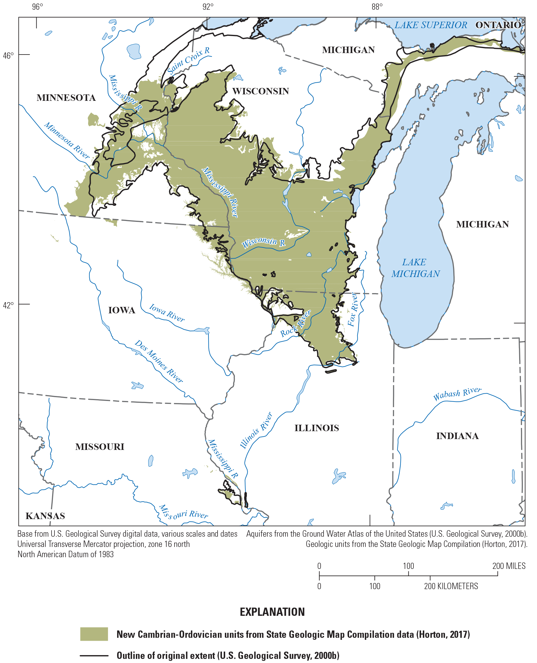
This pilot study involved analyzing available data to create finer scale two-dimensional boundaries of a selection of principal aquifers, defining a workflow, creating new boundaries, and reinterpreting the boundaries for several adjacent aquifer systems in the upper Midwest. The aquifers chosen were a mix of two larger principal aquifers that were the subject of previous regional analysis (but were not remapped as part of that effort) and two smaller minor aquifers. This selection of aquifers is intended to provide a representative sample of the kinds of data that are and are not available for future work and describe how some of the smaller aquifers might be treated. The aquifers included in this pilot study are listed in table 1 and shown in figure 1. The two larger aquifers (the Cambrian-Ordovician aquifer system and the Silurian-Devonian aquifer) were not remapped during the pilot RGA study, unlike many of the subsequent RGA study aquifers. Two of the aquifers (the Jacobsville and Cambrian-Ordovician aquifers) were shown in the original Ground Water Atlas of the United States (U.S. Geological Survey, 2000b) with their subsurface extents, but the Silurian-Devonian aquifer was not delineated in the subsurface in the atlas. The upper carbonate aquifer does not have a subsurface extent that is mapped explicitly. The subsurface extent of the Jacobsville and Cambrian-Ordovician aquifers as originally mapped is shown in figure 1.
Table 1.
Principal aquifers included in the U.S. Geological Survey National Hydrologic Geospatial Fabric pilot study.[Mgal/d, million gallons per day; mi2, square mile; RGA, regional groundwater availability; WI, Wisconsin; MN, Minnesota; MI, Michigan; IL, Illinois; IA, Iowa; KY, Kentucky; OH, Ohio; IN, Indiana]
| Name | 2015 total water use, in Mgal/d (Lovelace and others, 2020b) | Area (on the land surface), in mi2 | States covered | RGA study |
|---|---|---|---|---|
| Cambrian-Ordovician aquifer system | 921.3 | 46,655 | WI, MN, MI, IL | Yes, part of a pilot study. |
| Silurian-Devonian aquifer | 473.9 | 55,925 | IA, WI, IL, MI, KY, OH, IN | Yes, part of a pilot study. |
| Upper carbonate aquifer | 12.4 | 5,457 | MN, IA | No. |
| Jacobsville aquifer | 6.5 | 2,343 | MI | No. |
Principal aquifers included in the pilot study to create finer scale (version 2) aquifer boundaries.
Resources Used
Each analysis began with the national-level principal aquifers dataset (U.S. Geological Survey, 2003), which includes the surface extent of each aquifer. The Ground Water Atlas of the United States segments (U.S. Geological Survey, 2000b) include maps for many of the principal aquifers that depict the extent of the aquifer at depth as well (these were not included in the national-scale map compilation), many of which are available as geospatial datasets. Each of the aquifers in this group has a geodatabase available online (U.S. Geological Survey, 2000a, c, d, e). If further work was done for RGA studies, those datasets also were used. For the current pilot work, only the Lake Michigan Basin groundwater model (Lampe, 2009; Feinstein and others, 2010) was part of an RGA study, which included part of the Cambrian-Ordovician aquifer and part of the Silurian-Devonian aquifer. For the Cambrian-Ordovician and Silurian-Devonian aquifers, the Ground Water Atlas of the United States (U.S. Geological Survey, 2000b) used earlier RASA studies, which included surface elevation maps (such as Mandle and Kontis [1992] for the Cambrian-Ordovician aquifer) to show contours of the aquifer surfaces and which are included in the geodatabase on the USGS Water Mission Area National Spatial Data Infrastructure Node (U.S. Geological Survey, 2015a, b).
The principal source used here for the finer scale spatial boundaries was the SGMC geodatabase (Horton, 2017), which is a national-level spatial database of 48 State geologic maps that range in scale from 1:50,000 to 1:1,000,000. An important feature of the SGMC geodatabase is that each rock unit contains lithology information (primary and secondary) as well as age (minimum and maximum age ranges, in terms of the major divisions on the geologic time scale) These data were critical to applying the definitions of the original principal aquifers to these finer scale units.
An additional ancillary source of information was the secondary hydrogeologic regions (SHRs; Belitz and others, 2018). The SHRs categorized the spaces between the mapped principal aquifers. The SHRs may be geologic units that can transmit small amounts of water, or they may act as confining units between aquifers. The SHRs also are based on a database of the Geologic Map of North America (Garrity and Soller, 2009), and the SGMC units and represent the hydrogeologic units between principal aquifers in terms of lithology and whether they overlie a principal aquifer or lie underneath a surficial aquifer.
Several other local resources were brought to bear on the principal aquifer extent analysis, including publications about the extent, age, and makeup of specific geologic units that compose these aquifers and some additional groundwater model references for areas within each of these principal aquifers.
General Analysis Methodology for Geospatial Units
To be consistent about the analysis of the potential new principal aquifer boundaries, some rules to evaluate the mapping strategy and aquifer definitions were developed:
-
• Carefully consider the original principal aquifer definitions, complete basic background research on the groups of geologic units included in the definitions, and determine an appropriate combination of lithology and age/stratigraphy to apply to geologic units mapped at a finer scale in the SGMC geodatabase (Horton, 2017). In this context, evaluate available stratigraphic charts that show the definitions of the geologic units in the Ground Water Atlas and any studies conducted as part of a RASA/RGA study.
-
• Determine if units included in or excluded from a principal aquifer were inconsistent with the stated definition of the aquifer in the Ground Water Atlas of the United States (U.S. Geological Survey, 2000b).
-
• Investigate whether the aquifer definitions would be improved by applying more consistent rules to the geologic units that participate (or could participate) in the principal aquifer.
For each principal aquifer investigated, the first step was to read and review the segment of the Ground Water Atlas of the United States (U.S. Geological Survey, 2000b) associated with the principal aquifer and look at the rationale behind how the principal aquifer was defined lithologically and stratigraphically. If inconsistencies between the rationale and what was delineated were detected, that principal aquifer was investigated more carefully. In some cases, the distinction between two principal aquifers seemed somewhat arbitrary, which justified a reevaluation of the definition. Rethinking the definition was done in consultation with other geologic publications to determine if the approach was justified. Some revisions of the aquifers after the publication of the Ground Water Atlas were made in preparing the printed map (U.S. Geological Survey, 2003), and are documented in the metadata for the 1:5,000,000-scale data (available at https://water.usgs.gov/GIS/metadata/usgswrd/XML/aquifers_us.xml) for the printed map (U.S. Geological Survey, 2003).
Once the background analysis was completed, the geospatial units from the principal aquifer map and the belowground areas were put on a map. The SGMC data were overlain on the principal aquifer outline. An ipython (version 3.6; Pérez and Granger, 2007) jupyter notebook (Granger and Pérez, 2021) using the geopandas package (Jordahl and others, 2020) was developed to use the general definition of the principal aquifer (based on the States covered, lithology, and age of the units) to select polygons from the SGMC dataset. The resulting selection of geologic units was overlaid on the original principal aquifer using ArcMap (version 10.8). The principal aquifer definitions in the Ground Water Atlas of the United States (U.S. Geological Survey, 2000b) generally include the formations and formation groups, which were cross-checked against the SGMC units selected using the lithology, stratigraphic charts in the Ground Water Atlas, and age data. The resulting candidate selection of SGMC polygons was used to create a large shapefile of the SGMC units tagged with the principal aquifer attributes.
Once the candidate polygons from the SGMC were selected and compared to the original principal aquifer extent, they were hand-edited, making refinements based on the “Unit_Name” field, which principal aquifer was mapped at that location or nearby, and after researching the tectonic structural setting that applies to the geologic units composing the aquifer. The tectonic structure setting was useful for understanding whether or not the unit mapped at the surface is buried by younger units at their edge or if the unit mapped at the surface is at an erosional edge. Because most of the aquifers in this study area are sedimentary, this consideration was important for making a judgement of whether a small, mapped polygon was likely to be part of a wider, regionally continuous aquifer or aquifer system or was an isolated erosional remnant with older rocks underneath that are not part of the aquifer system. Small isolated erosional remnant polygons were generally removed from the set for a given aquifer.
In some cases, decisions were made about individual formations in specific States as to whether they should be included or excluded from the SGMC selection. There were some cases where the state geologic maps differed somewhat in how they mapped rocks that were assigned to a particular time period or range in lithologies such that one interpretation would cut the aquifer boundary at the state line. If possible, this was avoided to keep the updated aquifer boundary as close to the originally mapped boundary as possible. Another important consideration in the analysis was the definition of what units separate adjacent principal aquifers from one another, and whether these decisions were consistently applied across the extent of each principal aquifer.
A graphical depiction of these steps outlined previously is shown in an abbreviated format as a flow chart in figure 2. Part A includes the steps to evaluate how the original principal aquifer was defined, determine whether any adjustments may be warranted, and make the initial selection of proposed geologic units from the SGMC database (Horton, 2017) that should be included in the update. Part B includes the refining of the selection of geologic units based on the adjacent relations of other principal aquifers and the tectonic/structural setting of the candidate units to finalizing the units to be included in the updated set of units. Part C on the flow chart is not expanded but includes collecting the appropriate metadata for inclusion in a final geographic information system dataset. The application of these principles and steps is illustrated in the following sections on the analysis of the aquifer boundaries in the selected aquifers in this pilot study area.
Steps for evaluating and updating the principal aquifers to a finer scale using the U.S. Geological Survey State Geologic Map Compilation (SGMC) dataset (Horton, 2017).
Analysis of Aquifer Boundaries in the Pilot Study Area
Four principal aquifers in the upper Midwest were used as test cases for updating the boundaries to a scale better suited to regional analysis than the original principal aquifers dataset. The Cambrian-Ordovician aquifer system, Silurian-Devonian aquifer, Jacobsville aquifer, and upper carbonate aquifer (table 1) form a generally contiguous set of aquifers that could be analyzed with respect to one another in the pilot study. The methods described previously were applied to the definitions and boundaries of these principal aquifers using the SGMC geodatabase (Horton, 2017).
Cambrian-Ordovician Aquifer System
The Cambrian-Ordovician aquifer system (fig. 1) is the most heavily used aquifer system in the pilot study area, having 921.3 million gallons per day (Mgal/d) of withdrawals (Lovelace and others, 2020b). It is described primarily in terms of time-stratigraphic units, with a minor focus on lithology. Segment 9 of the Ground Water Atlas of the United States (Olcott, 1992) provides an extensive definition of the aquifer system and covers most of the extent, although a small area of the South is covered in Segment 10 of the Ground Water Atlas of the United States (Lloyd and Lyke, 1995). According to Olcott (1992), the aquifer system is composed of two primary sandstone aquifers (the Mount Simon and Ironton-Galesville aquifers) and a sandstone-dolomite aquifer (the St. Peter-Prairie du Chien-Jordan aquifer) and has some intervening confining units. The top of the aquifer system (where it is covered by other units) is the top of the regional shale-rich Maquoketa Formation, which is at the top of the Ordovician system in the midwestern States. Previous study of the Lake Michigan Basin (Lampe, 2009; Feinstein and others, 2010) included the eastern part of this aquifer system, but refining the aquifer boundaries was not within the scope of that study. The Lake Michigan Basin study modeled the individual aquifers within the Cambrian-Ordovician aquifer system. Geospatial data from that study, including the subsurface extent for the Cambrian-Ordovician aquifer system (U.S. Geological Survey, 2015b) are available at https://water.usgs.gov/GIS/metadata/styles/landingPage/ds33camord_a10.xml.
Some inconsistencies in the application of the stated definition of the Cambrian-Ordovician aquifer system could be removed with the refinement of the aquifer boundaries. The definition in Olcott (1992) references earlier work for the RASA program, in particular, Young (1992) and Mandle and Kontis (1992). The earlier definitions discuss an underlying unit, the Hinckley Sandstone, which is a Precambrian aquifer in Minnesota that is adjacent to the Cambrian Mount Simon aquifer. Young (1992) does not include the Hinckley Sandstone in the Cambrian-Ordovician aquifer system, while Olcott (1992) does. Olcott (1992) also extended the definition to include another Precambrian sandstone aquifer in northern Wisconsin, the Bayfield Group, without much of an explanation. Although in southern Minnesota, the Hinckley Sandstone is in hydraulic connection with the overlying Mount Simon aquifer, an argument could be made that the Hinckley Sandstone does not belong in the Cambrian-Ordovician aquifer system because it is much older and part of a completely different depositional system, the Midcontinent Rift (Ojakangas and others, 2001). Wilson (2012) has removed both the Hinkley Sandstone and Bayfield Group from analysis of the Cambrian-Ordovician aquifer. Ojakangas and others (2001) show the depositional and lithologic relation between the Hinckley Sandstone, Fond du Lac Formation (another sandstone in northern Minnesota lumped in the Cambrian-Ordovician aquifer system), Bayfield Group, and Jacobsville Sandstone in Michigan.
Along the northern edge of the Cambrian-Ordovician aquifer system in Wisconsin (fig. 3), the SGMC units that are sandstones do not extend as far north in some areas, and extend farther in others, portraying a more accurate boundary between the sedimentary aquifer and crystalline bedrock compared to the Ground Water Atlas of the United States (U.S. Geological Survey, 2000b). In Minnesota, the finer detail of the SGMC geodatabase added new areas to the Cambrian-Ordovician aquifer system and removed others, based on the lithology and rock types that the Ground Water Atlas intended to include. Additionally, in the process of selecting units from the SGMC geodatabase that should be included in the finer scale Cambrian-Ordovician aquifer system and the necessity to correlate the units across state lines, discontinuities in the location of geologic units resulting from different approaches to mapping units along the border between Iowa, Wisconsin, and Illinois became evident.
One set of geologic units that could benefit from clarification in the definition of the Cambrian-Ordovician aquifer system is the Galena Dolomite and Platteville Limestone, two carbonate-rich units that sit on the top of the mostly sandstone aquifer system. At the level of detail included in the SGMC geodatabase, in most areas these units are contiguous with other rocks that participate in the Cambrian-Ordovician aquifer system, but in some areas where they occur, they crop out far from other parts of that aquifer. In this pilot analysis of refining the principal aquifer boundaries, the decision was made to include the Galena and (or) Platteville units in the Cambrian-Ordovician aquifer system when they were determined to be contiguous with the rest of that aquifer system, but if they were not contiguous with sandstones in the Cambrian-Ordovician aquifer system, these dolomites were lumped with contiguous carbonates in an adjacent principal aquifer (see discussion on the upper carbonate and Silurian-Devonian system, later in this section). Grouping the Galena Dolomite with the upper carbonate aquifer in southeastern Minnesota is consistent with stratigraphic distinctions in Olcott (1992).
The results of refining the Cambrian-Ordovician aquifer system boundary, using the SGMC geodatabase of geologic units and the logic outlined previously and in figure 2, are shown in figures 3 and 4. Only the surface map of the aquifer boundary was reanalyzed. The specific additions and subtractions from the original boundary are indicated in figure 3, including the removal of the Precambrian Hinckley Sandstone and Bayfield Group, which is discussed in more detail later in this section. A simplified version of the new finer scale extent of the aquifer boundary compared to the old version is shown in figure 4. An important note for both figures 3 and 4 is that the Cambrian-Ordovician aquifer system does extend at depth below the Silurian-Devonian aquifers to the east (under Lake Michigan) and to the southwest (under Iowa and Illinois).
Changes made to the Cambrian-Ordovician aquifer system boundary.
Simplified changes made to the Cambrian-Ordovician aquifer system boundary.
The Cambrian-Ordovician aquifer system is thin and not particularly useful for water supply in some places, and the geologic units can be heterogenous in terms of whether they are locally aquifers or confining units (Ken Bradbury, Wisconsin Geologic and Natural History Survey, oral commun., 2021). The original published information about the Cambrian-Ordovician aquifer system (Olcott, 1992) does not indicate where the individual aquifer units contained in the aquifer system are thin or contain mixed lithologies, which could limit their usefulness to potential users of the data. The approach described in this report can better represent details about heterogeneities such as these, particularly in the metadata describing aquifer characteristics (see next subsection).
Jacobsville Aquifer
The second aquifer in this pilot study for analysis was the Jacobsville aquifer. This aquifer (fig. 1), composed of a Precambrian sandstone in the Upper Peninsula of Michigan, was designated a major aquifer because it is the only source of groundwater where it is present (Olcott, 1992). This unit is part of a series of structurally and diagenetically correlated sandstones in the Precambrian Midcontinent Rift (Ojakangas and others, 2001), discussed in the earlier section on the Cambrian-Ordovician aquifer system, many of which also are locally important sources of groundwater. Although the Midcontinent Rift units have structural, lithologic, and time-stratigraphic coherence, they were not grouped together into one aquifer system in the original principal aquifer designations. For example, the Bayfield Group in northern Wisconsin, which is central to the Midcontinent Rift units, was recognized as an important aquifer but was lumped with a different aquifer system, the Cambrian-Ordovician aquifer system (even though it is not Cambrian-Ordovician in age).
The position of the Jacobsville aquifer in context with the other Midcontinent Rift sandstones is shown in figure 5. For the current analysis, it made more sense in this context to redefine the Jacobsville aquifer and other correlative sandstones as the “Midcontinent Rift sandstone aquifers” (fig. 6), including the Oronto Group, which is a finer grained sedimentary unit in the Midcontinent Rift along the shore of Lake Michigan in the western section of the Upper Peninsula of Michigan but is locally also used as a minor aquifer.
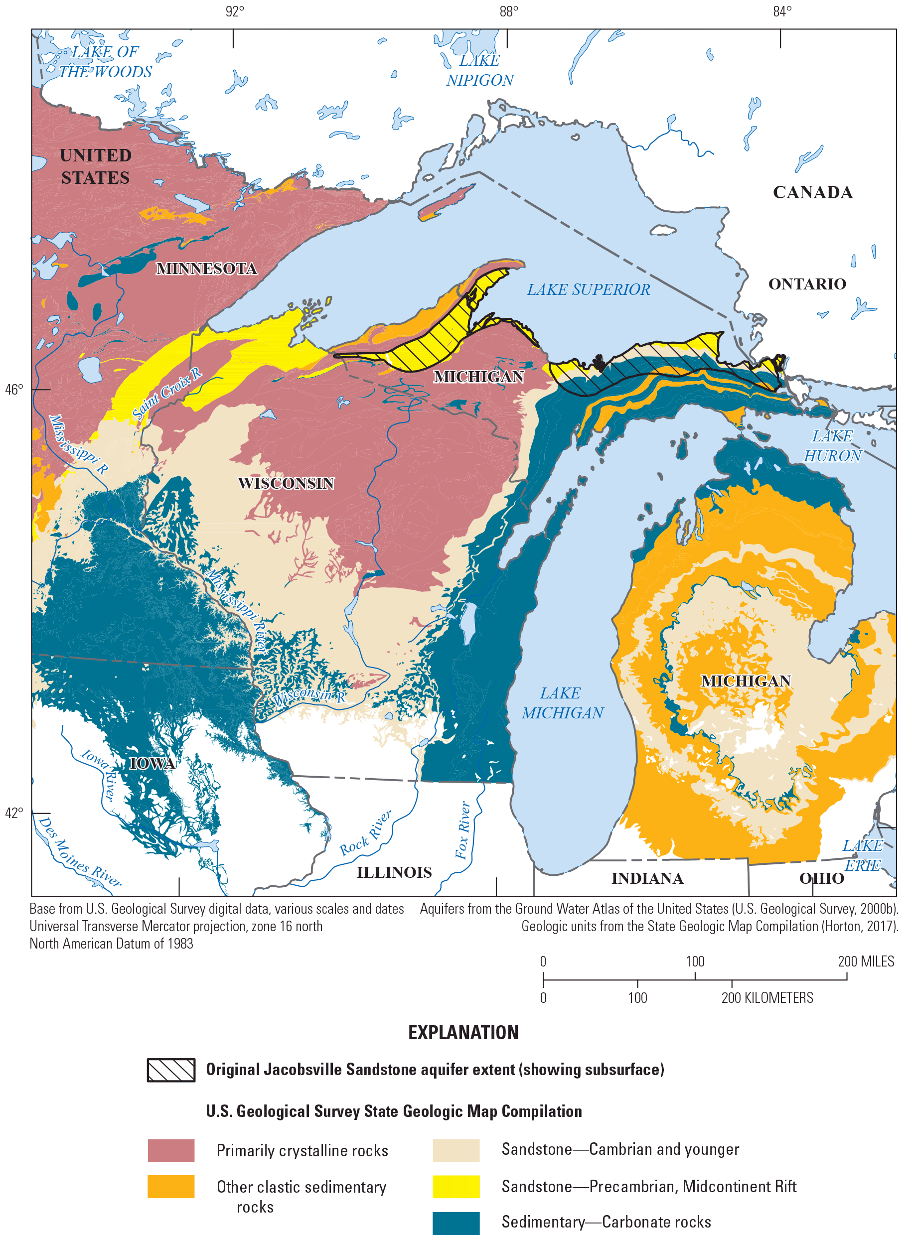
Jacobsville aquifer and other Precambrian sandstones of the Midcontinent Rift system.
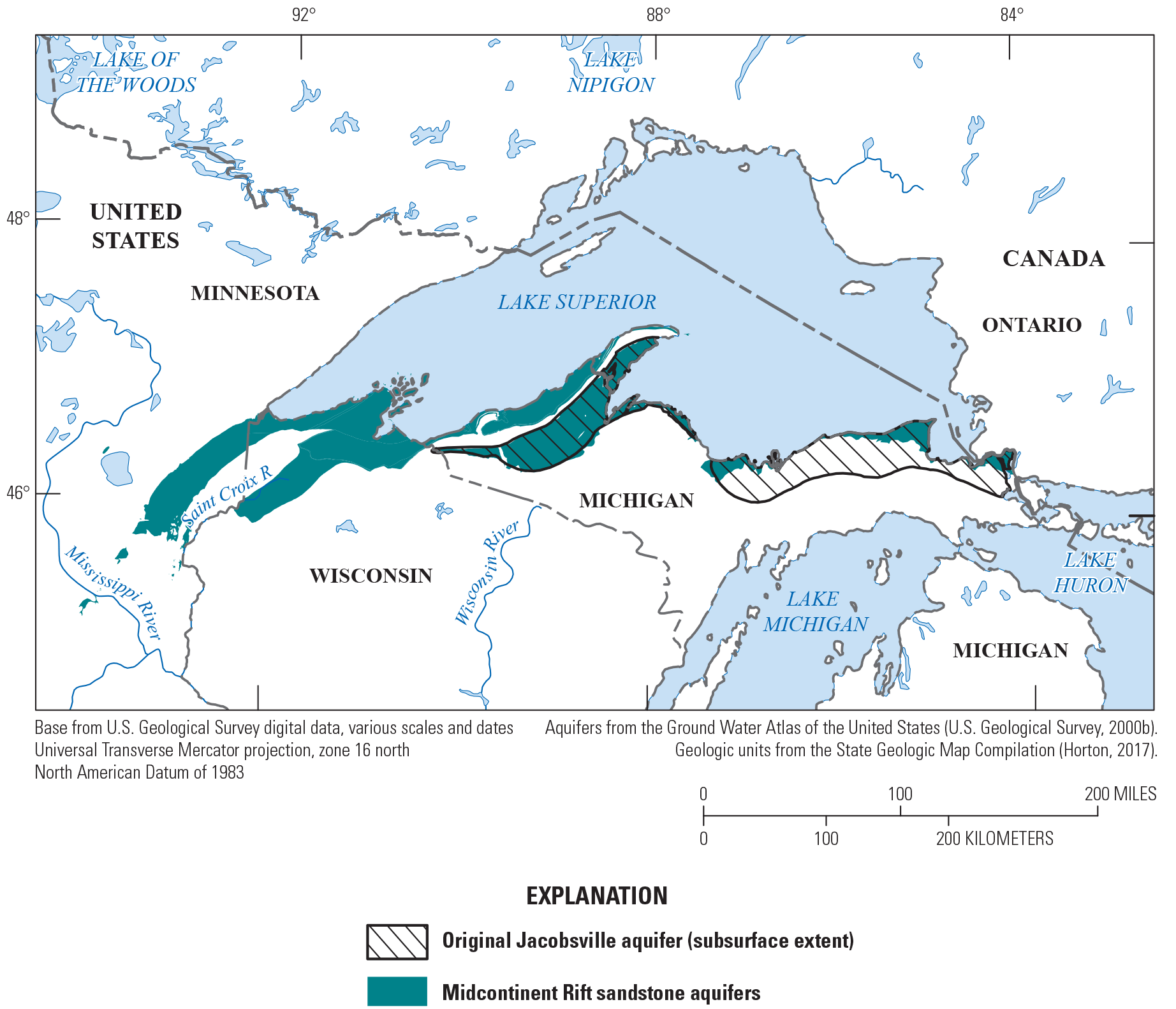
Redefined Midcontinent Rift sandstone aquifers.
Silurian-Devonian and Upper Carbonate Aquifers
The Silurian-Devonian aquifer and adjacent upper carbonate aquifer (fig. 1) cover a large part of the upper Midwest and accounted for a total of 486.3 Mgal/day of withdrawals in 2015 (Lovelace and others, 2020b). The upper carbonate aquifer is described in Olcott (1992) as part of Segment 9 in the Ground Water Atlas of the United States. About one-half of the Silurian-Devonian aquifer is in Segment 9 of the Ground Water Atlas of the United States (Olcott, 1992), and the other half is in Segment 10 (Lloyd and Lyke, 1995). The upper carbonate aquifer, which exists principally in southern Minnesota and northern Iowa, is defined by lithology alone, but the Silurian-Devonian aquifer is defined primarily by time-stratigraphic units (although the principal lithology is dolomite and limestone). The Silurian-Devonian aquifer is not a wholly contiguous unit but has two major segments: an eastern part surrounding the lower peninsula of Michigan and the Michigan Basin (outcropping in eastern Wisconsin, northeastern Illinois, northern Indiana and Ohio, and northern Michigan) and a western part (outcropping primarily in southwestern Wisconsin, eastern Iowa, and northwestern Illinois; fig. 1). The Silurian-Devonian sediments thin and are eroded away between these two segments. Small erosional remnants also occur on the border between Illinois and Missouri and in central Kentucky.
The upper carbonate aquifer is defined in Minnesota and Iowa only (fig. 1) and fills the northern part of the Hollandale Embayment. It is primarily karstic, with some shaly layers, and is very productive (U.S. Geological Survey, 2000b). Because it is defined by lithology, not stratigraphy, the treatment of geologic units between this principal aquifer and adjacent correlative units is not consistent and may lead to some confusion; for example, the top of the Cambrian-Ordovician aquifer in Wisconsin and points east is within the Maquoketa confining unit (Olcott, 1992), but in Minnesota and Iowa, the Ordovician rocks (some of which are water bearing) extend above and into the upper carbonate aquifer. The Ordovician-age Galena Dolomite and Platteville Limestone are within the series of units within the upper carbonate aquifer in Iowa and Minnesota, even though farther to the east (in Wisconsin and Illinois), they are part of the top of the Cambrian-Ordovician aquifer.
Except for the upper Ordovician rocks, the upper carbonate aquifer is mostly Devonian, as the Silurian is missing from the section in Minnesota. Although the Cedar Valley Limestone is a major part of the upper carbonate aquifer in Minnesota, it is part of the Silurian-Devonian aquifer in Iowa. Thus, the dividing line between what composes the upper carbonate aquifer and what is included in the Silurian-Devonian aquifer is rather arbitrary and could be confusing. Because both aquifers are primarily composed of carbonate rocks that are mostly Silurian and Devonian in age, and the distinction between them is not entirely clear where they are adjacent to one another, it makes some sense to combine them into one larger aquifer system. This could be especially helpful for a regional-scale study that uses a finer resolution geologic dataset, in which deciding where the stratigraphic boundary between two adjacent aquifers or aquifer systems could be a difficult exercise.
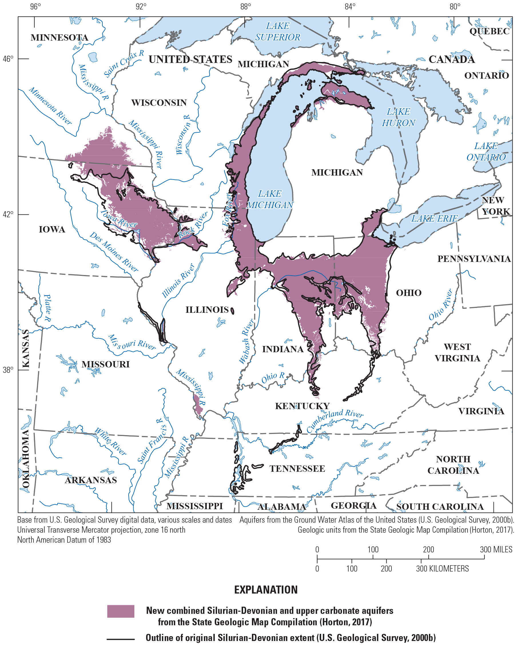
The changes as described to the Silurian-Devonian aquifer system, including the addition of the upper carbonate aquifer to the overall system, are shown in figures 7 and 8. Details of additions and subtractions of units using the SGMC geodatabase (Horton, 2017) are shown in figure 7, and the overall changes are illustrated more simply in figure 8.
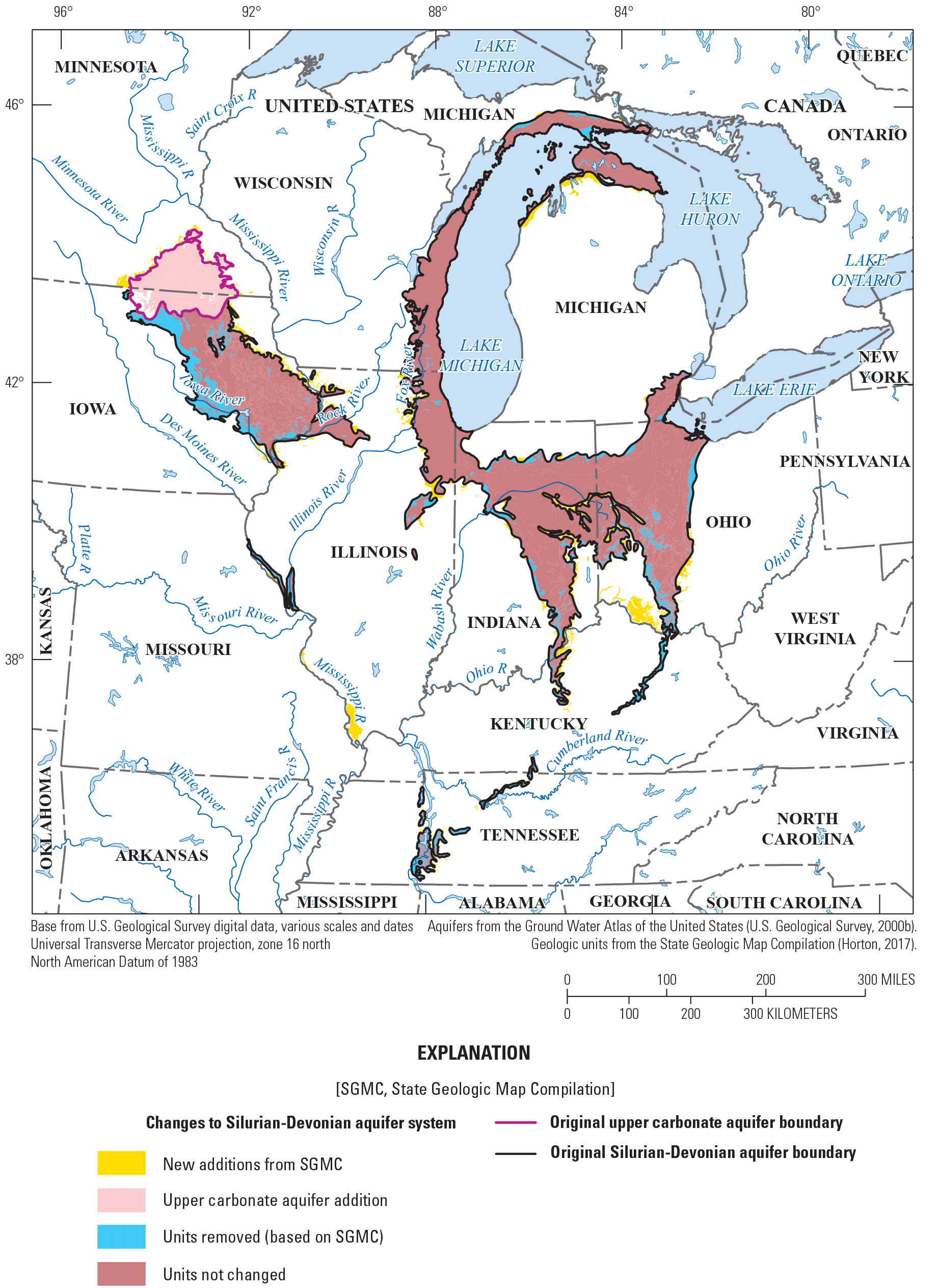
Changes made to the Silurian-Devonian aquifer system, using the U.S. Geological Survey State Geologic Map Compilation data (Horton, 2017), with additions of the upper carbonate aquifer units.
Simplified combined Silurian-Devonian and upper carbonate aquifers.
Units removed from the SGMC selection covering the original Silurian-Devonian aquifer include units that are older than Silurian in age (meaning that the younger Silurian-Devonian rocks have been eroded off the top), units that are primarily shales, and some units that are thin, disconnected pieces/erosional remnants that are not large or widespread enough to participate in a regional aquifer. Units added to the Silurian-Devonian aquifer included the Galena Dolomite and Platteville Limestone in Iowa or Illinois, where they were contiguous with the Silurian-Devonian aquifer but disconnected by a confining unit from the Cambrian-Ordovician aquifer system (a dominantly sandstone aquifer in which they were originally included). This is an example of examining how units at the stratigraphic and geographic edges of the principal aquifer delineations were treated, favoring including units that are contiguous, likely to be hydraulically connected, and lithologically similar and differentiating them from other nearby aquifers if they are not likely to be hydraulically connected with the other aquifer.
Combined Pilot Principal Aquifers—Fine Scale
Using the SGMC data (Horton, 2017) and workflows described previously, the extent of the updated (version 2) finer scale principal aquifers for the upper Midwest (Cambrian-Ordovician aquifer system, Midcontinent Rift sandstone aquifers, Silurian-Devonian-upper carbonate aquifers) are illustrated in figure 9. The Midcontinent Rift sandstone aquifers and Silurian-Devonian-upper carbonate aquifers are newly defined in this report.
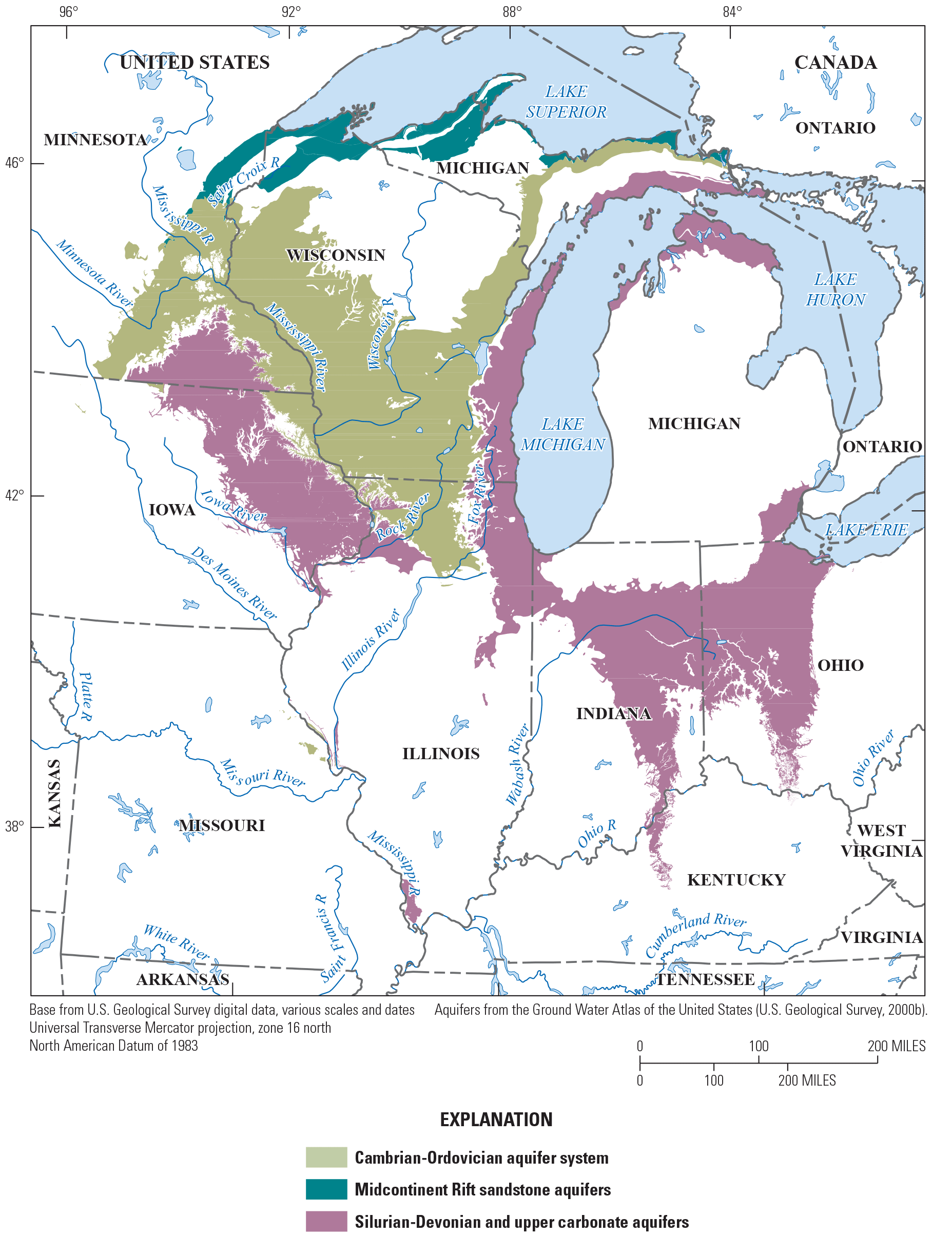
Fine-scale principal aquifers of the upper Midwest based on the State Geologic Map Compilation dataset (Horton, 2017).
The workflow prototyped in this study could be applied to areas recently the target of USGS regional models. Other principal aquifers involved in RGA studies that produced finer scale aquifer boundaries, useful for redefining principal aquifer extents at scales comparable to this pilot project, include the Upper Cretaceous aquifers (Thamke and others, 2014), High Plains aquifer (Qi, 2010), Columbia Plateau basaltic-rock and Columbia Plateau basin-fill aquifers (Burns and others, 2011), Central Valley aquifer system (Faunt, 2009), and the Floridan aquifer system (Williams and Kuniansky, 2016), among others (fig. 10). In future analyses, the refined spatial extents of these aquifer systems would be appropriate to add to the prototype analysis included in this pilot study as additions to the version 2 principal aquifer dataset.
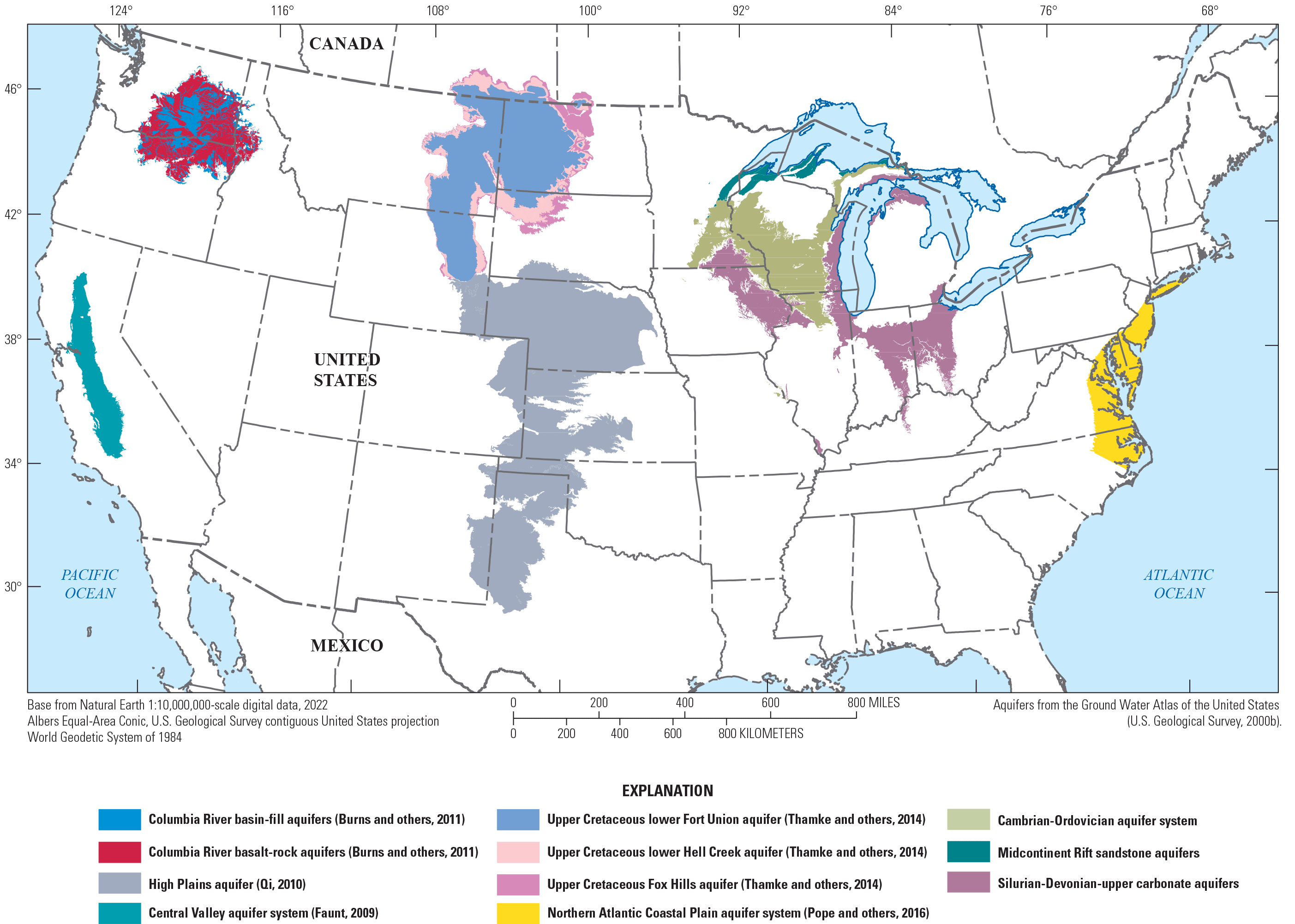
Updated principal aquifers and other principal aquifer boundaries updated in groundwater availability studies since 2008.
Considerations for Future Analysis of Updated Principal Aquifers
If this work to refine the principal aquifers dataset continues, several issues that were noted should be planned for in continuing this work to completion for the entire conterminous United States, particularly for those principal aquifers that were not remapped as part of an RGA study. These issues include mapping belowground extents of aquifers where the aquifer is not the topmost geologic unit, addressing state-line discontinuities resulting from the geologic mapping differences from state to state and how the principal aquifers were defined in adjacent segments of the Ground Water Atlas of the United States (U.S. Geological Survey, 2000b), improving the geologic and hydrologic consistency in the definitions of the principal aquifers, and using geochemistry and salinity data to define the subsurface extent of usable water in aquifers that are part of extensive geologic units with varying water quality at depth. Other hydrologic and geologic information that may be important for assessing water movement within and between aquifer units includes the degree to which these aquifers and aquifer systems are hydrologically connected (or separated) and how homogeneous or heterogeneous the aquifers and aquifer systems are with respect to water movement, but those would be best assessed in other kinds of dataset products. An exercise to create a consistent definition of salinity limits on aquifer definitions and degrees of aquifer connection would provide important guidance in this task.
The original Ground Water Atlas of the United States (U.S. Geological Survey, 2000b) did provide subsurface extents of many of the aquifers and aquifer systems, which in this pilot study area included the Cambrian-Ordovician aquifer system and the Jacobsville aquifer (fig. 1). Adding areas to the extent of the finer scale Cambrian-Ordovician aquifer system that indicate where the aquifer exists below younger mapped geologic units would be possible, especially at the edges where it lies stratigraphically below the Silurian-Devonian-upper carbonate aquifer system and below the intervening Maquoketa Shale. Defining the extent further under the Silurian-Devonian-upper carbonate aquifer system down into Missouri would involve additional work but could potentially be accomplished using stratigraphic data analysis gleaned from well logs. A similar analysis and mapping exercise could be accomplished for the Midcontinent Rift sandstone aquifers as well, although the data to define the subsurface extent may not be as readily available as for the Cambrian-Ordovician aquifer system.
The USGS SGMC (Horton, 2017) made some improvements to inconsistencies in mapping geologic units across state boundaries, where earlier mapped geologic unit boundaries abruptly changed location crossing from one state to another, compared to some of the original mapping used to define the principal aquifers, but additional improvements are yet to be made. Some of these inconsistencies are most apparent at the edges of the Cambrian-Ordovician aquifer system and the mapping of units at the top of the stratigraphic section (the Galena Formation and Plattsville Formation, in particular), and the mapping of units that formed the basis of divisions between the Silurian-Devonian and upper carbonate aquifers, which was one factor in deciding to join those into one aquifer system. Besides the inconsistencies in geologic mapping, inconsistencies also were noted in the definition of some of the principal aquifers that crossed the boundaries of the segments (or regions) of the Ground Water Atlas of the United States (U.S. Geological Survey, 2000b) because different groups of authors worked on each segment and the definitions of the aquifers were not made consistent between adjacent segments. These issues were carefully considered in this pilot study, and it would be beneficial to consider them in further attempts at extending the finer scale mapping to the rest of the United States.
Recent work on the distribution of brackish and saline groundwater in the United States (Stanton and others, 2017) provides an indepth analysis of the limitations of groundwater at depths below 500 feet for various human uses. The report discusses the brackish groundwater zones in each of the principal aquifers, including the geologic setting and depths and extents of the brackish zones in each. The accompanying dataset (Qi and Harris, 2017) includes well locations, geochemistry and salinity data, and depths for brackish and saline waters, which could be used as an overlay with the principal aquifers to qualify the freshwater resources available for use as part of a further development of the principal aquifers mapping effort.
Prototype Version 2 Principal Aquifer Dataset
The product of this pilot study to reanalyze the principal aquifers at a finer scale is a prototype dataset (in ArcGIS shapefile format) of the three version 2 principal aquifers described previously, which is published as an accompanying USGS data release (Nielsen, 2023) to this report. The prototype version 2 principal aquifers shapefile consists of individual polygons from the source data (SGMC geodatabase for the aquifers included in this pilot study [Horton, 2017]), and each version 2 principal aquifer shown in the figures in this report consists of several hundred to more than 1,000 individual polygons. This dataset includes several metadata fields not included in the original version of the principal aquifers data that should be useful descriptors of the aquifer and provide important lineage information on the data used to produce the aquifer extents. Some of these fields include the named geologic units that are mapped, the vertical position of the aquifer (whether the aquifer is the uppermost aquifer in the area), the type of porosity, the source of the information used, links to the older versions of the original principal aquifer designation, the source (citation) of the definition of the updated version, and other attributes (table 2). As noted earlier, a separate project is collecting information on the three-dimensional surfaces of the principal aquifers, so information on thickness and depth of the aquifers is not included in this prototype dataset.
Table 2.
Data attributes of the prototype version 2 principal aquifers shapefile.[SGMC, State Geologic Map Compilation (Horton, 2017)]
Although it would be useful for users of these data to have information on the ranges of hydraulic properties of the aquifers, these attributes are highly variable at the local scale and are often not well characterized; therefore, including them in this dataset would not provide information that would be usable at the intended scale of these data.
Summary and Conclusions
The principal aquifers of the United States have been used for several decades as useful constructs around which to describe and analyze the groundwater resources of the Nation. At regional and finer scales, however, the 1:5,000,000 data that have been published are not suitable for many kinds of analyses. Regional groundwater availability studies conducted on 18 of the principal aquifers since 2003 have generally included a remapping of the principal aquifers to incorporate more local-scale information and to refine the definitions of the principal aquifers themselves. To date, however, these updates to the principal aquifers have not been collected into a single resource for convenient access. To meet the science goals of the U.S. Geological Survey (USGS) as outlined in Miller and others (2022), more accurate, detailed, and stable definitions of these hydrogeologic units are needed for understanding the hydrogeologic context of existing and new groundwater data and for assessing the availability and quality of water resources for the future. Although several principal aquifers already have been included in updated regional studies that included refining definitions and updating the spatial data, most of the original 62 principal aquifers have not had that level of attention. This report outlines a pilot workflow to use the USGS State Geologic Map Compilation geodatabase and other resources to refine the original principal aquifer definitions and create finer scale spatial data for the principal aquifers (version 2 data) that were not reevaluated and remapped as part of a regional aquifer study.
Four principal aquifers in the upper Midwest were included in this pilot study: the Cambrian-Ordovician aquifer system, the Jacobsville aquifer, the Silurian-Devonian aquifers, and the upper carbonate aquifer. After the definitions of these aquifers were carefully considered and evaluated, they were slightly refined with some consolidation and some expansion into three version 2 principal aquifers: the Cambrian-Ordovician aquifer system, the newly defined Midcontinent Rift sandstone aquifers (using components from the Jacobsville aquifer and parts of the Cambrian-Ordovician aquifer system and other rocks not previously included in a principal aquifer), and the Silurian-Devonian-upper carbonate aquifers, which were combined on the basis of lithology, age, and proximity. The three version 2 principal aquifers were mapped using the USGS State Geologic Map Compilation dataset polygons.
A prototype spatial dataset of the version 2 principal aquifers included in this pilot study, which includes much more information than the version 1 principal aquifers dataset, was developed from the USGS State Geologic Map Compilation data. The attributes of this dataset include information on the lithologies (major and minor), geologic ages, type of porosity, specific geologic units, lineage of the information, vertical information pertaining to geologic structure of the aquifer, and information about the version 1 aquifer from which the unit originally was derived.
Further efforts to continue this work could benefit from considering improving the geologic and hydrologic consistency in the definitions of the principal aquifers, addressing abrupt inconsistencies across state lines resulting from the geologic mapping differences from State to State and how the principal aquifers were defined in adjacent segments of the Ground Water Atlas of the United States, and adding the regional-scale principal aquifers spatial data that were developed over the past 20 years to the prototype version 2 dataset described herein.
References Cited
Belitz, K., Watson, E., Johnson, T.D., and Sharpe, J.B., 2018, Secondary hydrogeologic regions of the conterminous United States: Groundwater, v. 57, no. 3, p. 367-377, accessed September 2019 at https://doi.org/10.1111/gwat.12806.
Burns, E.R., Morgan, D.S., Peavler, R.S., and Kahle, S.C., 2011, Three-dimensional model of the geologic framework for the Columbia Plateau Regional Aquifer System, Idaho, Oregon, and Washington: U.S. Geological Survey Scientific Investigations Report 2010–5246, 44 p. [Also available at https://doi.org/10.3133/sir20105246.]
DeSimone, L.A., McMahon, P.B., and Rosen, M.R., 2014, The quality of our Nation’s waters—Water quality in principal aquifers of the United States, 1991–2010: U.S. Geological Survey Circular 1360, 151 p. [Also available at https://doi.org/10.3133/cir1360.]
Faunt, C.C., ed., 2009, Groundwater availability of the Central Valley Aquifer, California: U.S. Geological Survey Professional Paper 1766, 225 p. [Also available at https://doi.org/10.3133/pp1766.]
Feinstein, D.T., Hunt, R.J., and Reeves, H.W., 2010, Regional groundwater-flow model of the Lake Michigan Basin in support of Great Lakes Basin water availability and use studies: U.S. Geological Survey Scientific Investigations Report 2010–5109, 379 p. [Also available at https://doi.org/10.3133/sir20105109.]
Garrity, C.P., and Soller, D.R., 2009, Database of the geologic map of North America—Adapted from the map by J.C. Reed, Jr. and others (2005): U.S. Geological Survey Data Series 424. [Also available at https://doi.org/10.3133/ds424.]
Granger, B.E., and Pérez, F., 2021, Jupyter—Thinking and storytelling with code and data: Computing in Science & Engineering, v. 23, no. 2, p. 7–14. [Also available at https://doi.org/10.1109/MCSE.2021.3059263.]
Horton, J.D., 2017, The State Geologic Map Compilation (SGMC) geodatabase of the conterminous United States (ver. 1.1, August 2017): U.S. Geological Survey data release, accessed July 7, 2021, at https://doi.org/10.5066/F7WH2N65.
Jordahl, K., Van den Bossche, J., Fleischmann, M., Wasserman, J., McBride, J., Gerard, J., Tratner, J., Perry, M., Badaracco, A.G., Farmer, C., Hjelle, G.A., Snow, A.D., Cochran, M., Gillies, S., Culbertson, L., Bartos, M., Eubank, N., Albert, M., Bilogur, A., Rey, S., Ren, C., Arribas-Bel, D., Wasser, L, Wolf, L.J., Journois, M., Wilson, J., Greenhall, A., Holdgraf, C. and Leblanc, F., 2020, geopandas/geopandas—v0.8.1 (version 0.8.1): Zenodo software release, accessed July 30, 2021, at https://doi.org/10.5281/zenodo.3946761.
Lampe, D.C., 2009, Hydrogeologic framework of bedrock units and initial salinity distribution for a simulation of groundwater flow for the Lake Michigan Basin: U.S. Geological Survey Scientific Investigations Report 2009–5060, 49 p. [Also available at https://doi.org/10.3133/sir20095060.]
Lloyd, O.B., Jr., and Lyke, W.L., 1995, Ground Water Atlas of the United States—Segment 10, Illinois, Indiana, Kentucky, Ohio, Tennessee: U.S. Geological Survey Hydrologic Atlas 730–K, 30 p. [Also available at https://doi.org/10.3133/ha730K.]
Lovelace, J.K., Nielsen, M.G., Read, A.L., and Murphy, C.J., 2020a, Estimated groundwater withdrawals from principal aquifers in the United States—County-level data for 2015: U.S. Geological Survey data release, accessed July 1, 2021, at https://doi.org/10.5066/P9EI0KMR.
Lovelace, J.K., Nielsen, M.G., Read, A.L., Murphy, C.J., and Maupin, M.A., 2020b, Estimated groundwater withdrawals from principal aquifers in the United States, 2015: U.S. Geological Survey Circular 1464, 70 p. [Also available at https://doi.org/10.3133/cir1464.]
Mandle, R.J. and Kontis, A.L. 1992. Simulation of regional groundwater flow in the Cambro-Ordovician aquifer system in the northern Midwest, United States: U.S. Geological Survey Professional Paper 1405–C, 97 p. [Also available at https://doi.org/10.3133/pp1405C.]
Miller, J.A., 1999, Ground Water Atlas of the United States: Introduction and national summary: U.S. Geological Survey Hydrologic Atlas 730–A, 15 p., accessed February 2023 at https://doi.org/10.3133/ha730A.
Miller, M.P., Skalak, K., and Lesmes, D.P., 2022, Water priorities for the Nation—U.S. Geological Survey Integrated Water Prediction science program: U.S. Geological Survey Fact Sheet 2022–3028, 2 p., accessed July 20, 2022, at https://doi.org/10.3133/fs20223028.
Nielsen, M.G., 2023, Prototype updated principal aquifer datasets for three aquifer systems in the Upper Midwest, USA: U.S. Geological Survey data release, https://doi.org/10.5066/P9PF3PSM.
Ojakangas, R.W., Morey, G.B., and Green, J.C., 2001, The Mesoproterozoic midcontinent rift system, Lake Superior Region, USA: Sedimentary Geology, v. 141–142, p. 421–442. [Also available at https://doi.org/10.1016/S0037-0738(01)00085-9.]
Olcott, P.G., 1992, Ground Water Atlas of the United States—Segment 9, Iowa, Michigan, Minnesota, Wisconsin: U.S. Geological Survey Hydrologic Atlas 730–J, 31 p., [Also available at https://doi.org/10.3133/ha730J.]
Pérez, F., and Granger, B.E., 2007, IPython—A system for interactive scientific computing: Computing in Science & Engineering, v. 9, no. 3, p. 21–29. [Also available at https://doi.org/10.1109/MCSE.2007.53.]
Pope, J.P., Andreasen, D.C., McFarland, E.R., and Watt, M.K., 2016, Digital elevations and extents of regional hydrogeologic units in the Northern Atlantic Coastal Plain aquifer system from Long Island, New York, to North Carolina: U.S. Geological Survey Data Series 996, 28 p., accessed October 1, 2022, at https://doi.org/10.3133/ds996.
Qi, S.L., 2010, Digital map of the aquifer boundary for the High Plains aquifer in parts of Colorado, Kansas, Nebraska, New Mexico, Oklahoma, South Dakota, Texas, and Wyoming: U.S. Geological Survey Data Series 543 [digital data], accessed October 10, 2021, at https://doi.org/10.3133/ds543.
Qi, S.L., and Harris, A.C., 2017, Geochemical database for the brackish groundwater assessment of the United States: U.S. Geological Survey data release, accessed October 10, 2021, at https://doi.org/10.5066/F72F7KK1.
Stanton, J.S., Anning, D.W., Brown, C.J., Moore, R.B., McGuire, V.L., Qi, S.L., Harris, A.C., Dennehy, K.F., McMahon, P.B., Degnan, J.R., and Böhlke, J.K., 2017, Brackish groundwater in the United States: U.S. Geological Survey Professional Paper 1833, 185 p. [Also available at https://doi.org/10.3133/pp1833.]
Thamke, J.N., LeCain, G.D., Ryter, D.W., Sando, R., and Long, A.J., 2014, Hydrogeologic framework of the uppermost principal aquifer systems in the Williston and Powder River structural basins, United States and Canada (ver. 1.1, December 2014): U.S. Geological Survey Scientific Investigations Report 2014–5047, 38 p., accessed October 10, 2021, at https://doi.org/10.3133/sir20145047.
U.S. Geological Survey, 2000a, Cambrian-Ordovician aquifer system (version 2.0, updated February 2015): U.S. Geological Survey vector digital data, accessed July 2023 at https://water.usgs.gov/GIS/metadata/usgswrd/XML/cambrian-ordovician_aquifer_system.xml.
U.S. Geological Survey, 2000b, Ground water atlas of the United States: U.S. Geological Survey Hydrologic Atlas 730, [variously paged], accessed July 2023 at https://doi.org/10.3133/ha730.
U.S. Geological Survey, 2000c, Jacobsville aquifer (version 2.0, updated February 2015): U.S. Geological Survey vector digital data, accessed July 2023 at https://water.usgs.gov/GIS/metadata/usgswrd/XML/jacobsville_aquifer.xml.
U.S. Geological Survey, 2000d, Silurian Devonian aquifers (version 2.0, updated February 2015): U.S. Geological Survey vector digital data, accessed July 2023 at https://water.usgs.gov/GIS/metadata/usgswrd/XML/silurian-devonian_aquifers.xml.
U.S. Geological Survey, 2000e, Upper carbonate aquifer (version 2.0, updated February 2015): U.S. Geological Survey vector digital data, accessed July 2023 at https://water.usgs.gov/GIS/metadata/usgswrd/XML/upper_carbonate_aquifer.xml.
U.S. Geological Survey, 2003, Principal aquifers of the 48 conterminous United States, Hawaii, Puerto Rico, and the U.S. Virgin Islands: U.S. Geological Survey digital data, accessed September 24, 2021, at https://water.usgs.gov/lookup/getspatial?aquifers_us.
U.S. Geological Survey, 2015a, Geodatabase of the datasets that represent the three subareas of the Silurian-Devonian aquifer, Illinois, Indiana, Iowa, Kentucky, Michigan, Missouri, Ohio, Tennessee, and Wisconsin: U.S. Geological Survey digital data, accessed May 18, 2022, at https://water.usgs.gov/GIS/dsdl/ds47SLRDVN_A10_gdb.zip.
U.S. Geological Survey, 2015b, Geodatabase of the datasets used to represent the four aquifer subunits of the Cambrian-Ordovician aquifer system, Illinois, Iowa, Michigan, Minnesota, and Wisconsin: U.S. Geological Survey digital data, accessed May 18, 2022, at https://water.usgs.gov/GIS/dsdl/ds33camord_a10_gdb.zip.
Williams, L.J., and Kuniansky, E.L., 2016, Revised hydrogeologic framework of the Floridan aquifer system in Florida and parts of Georgia, Alabama, and South Carolina (ver. 1.1, March 2016): U.S. Geological Survey Professional Paper 1807, 140 p., 23 pls. [Also available at https://doi.org/10.3133/pp1807.]
Wilson, J.T., 2012, Water-quality assessment of the Cambrian-Ordovician aquifer system in the northern Midwest, United States: U.S. Geological Survey Scientific Investigations Report 2011–5229, 154 p. [Also available at https://doi.org/10.3133/sir20115229.]
Young, H.L., 1992, Hydrogeology of the Cambrian-Ordovician aquifer system in the northern Midwest, United States, with a section on Ground-water quality, by D.I. Siegel: U.S. Geological Survey Professional Paper 1405–B, 99 p., 1 plate. [Also available at https://doi.org/10.3133/pp1405B.]
For more information about this publication, contact:
Director, USGS Upper Midwest Water Science Center
1 Gifford Pinchot Drive
Madison, WI 53726
608–821–3817
For additional information, visit: https://www.usgs.gov/centers/umid-water
Publishing support provided by the
Rolla Publishing Service Center
Disclaimers
Any use of trade, firm, or product names is for descriptive purposes only and does not imply endorsement by the U.S. Government.
Although this information product, for the most part, is in the public domain, it also may contain copyrighted materials as noted in the text. Permission to reproduce copyrighted items must be secured from the copyright owner.
Suggested Citation
Nielsen, M.G., 2023, Documentation of a pilot workflow for reanalyzing the U.S. Geological Survey principal aquifers datasets and prototype principal aquifer version 2 dataset for three aquifer systems: U.S. Geological Survey Open-File Report 2023–1078, 23 p., https://doi.org/10.3133/ofr20231078.
ISSN: 2331-1258 (online)
Study Area
| Publication type | Report |
|---|---|
| Publication Subtype | USGS Numbered Series |
| Title | Documentation of a pilot workflow for reanalyzing the U.S. Geological Survey principal aquifers datasets and prototype principal aquifer version 2 dataset for three aquifer systems |
| Series title | Open-File Report |
| Series number | 2023-1078 |
| DOI | 10.3133/ofr20231078 |
| Publication Date | December 01, 2023 |
| Year Published | 2023 |
| Language | English |
| Publisher | U.S. Geological Survey |
| Publisher location | Reston, VA |
| Contributing office(s) | Upper Midwest Water Science Center |
| Description | Report: iv, 23 p.; Data Release |
| Country | United States |
| State | Illinois, Indiana, Iowa, Kentucky, Michigan, Minnesota, Missouri, Ohio, Tennessee, Wisconsin |
| Online Only (Y/N) | Y |
| Additional Online Files (Y/N) | N |