

Water-Level Change from a Multiple-Well Aquifer Test in Volcanic Rocks, Umatilla Indian Reservation near Mission, Northeastern Oregon, 2016
Links
- Document: Report (3.9 MB pdf) , HTML , XML
- Data Release: USGS data release - Multiple-well aquifer-test data and results, Umatilla Indian Reservation near Mission, northeastern Oregon
- NGMDB Index Page: National Geologic Map Database Index Page (html)
- Download citation as: RIS | Dublin Core
Acknowledgments
The authors thank the Confederated Tribes of the Umatilla Indian Reservation for providing the data, support, and funding for this project.
Abstract
The U.S. Geological Survey, in cooperation with the Confederated Tribes of the Umatilla Indian Reservation (CTUIR), (1) estimated water-level change from a multiple-well aquifer test centered on CTUIR well number 422 and (2) evaluated hydraulic connections between the pumping and observation wells on the Umatilla Indian Reservation near Mission, northeastern Oregon to improve the understanding of aquifer characteristics and hydrologic flow boundaries. Water-level changes, or pumping responses, were determined by distinguishing the pumping signal from environmental fluctuations in groundwater levels using analytical water-level models. The pumping well produces water from basalt units from a depth of 450 to 1,057 feet below land surface and was intermittently pumped during February 1–April 18, 2016. Water-level responses to pumping were estimated in the pumping well and in seven observation wells within 4 miles (mi) of the pumping well. The observation wells are open to basalt and some observation wells are either separated from the pumping well by faults and other structural features, within structural zones, or adjacent to structural features. Pumping responses at the observation wells were classified as detected in two wells, ambiguous in one well, and not detected in four wells. Observation-well open-interval elevations overlapped with the pumping-well open interval in both wells with detected pumping responses. Observation wells with detections are 1.8 mi east of the pumping well and across a fault, and 1.4 mi south of the pumping well. The pumping response was classified as ambiguous in an observation well located 1.4 mi west of the pumping well, where the dip of the basalt unit steepens, and adjacent to the Agency syncline. Pumping responses were not detected in observation wells within 0.3 mi of the pumping well where observation-well open-interval elevations are above the top of the pumping well open interval. Analysis of pumping responses indicates (1) a more permeable zone of basalt is adjacent to the lower portion of the pumping-well open interval and extends eastward, (2) basalt adjacent to the upper portion of the pumping-well open-interval is less permeable than the lower portion or separated from the lower portion by a less permeable zone, and (or) (3) a less permeable zone limits vertical hydraulic connectivity between the pumping well and the overlying basalt.
Introduction
The Confederated Tribes of the Umatilla Indian Reservation (CTUIR) have been conducting multiple-well aquifer tests to improve understanding of aquifer characteristics and hydrologic flow boundaries beneath the Umatilla Indian Reservation near Mission, northeastern Oregon (fig. 1). In this study, the U.S. Geological Survey, in cooperation with CTUIR, estimated water-level change from a multiple-well aquifer test centered on CTUIR well 422 and evaluated hydraulic connections between this pumping well and seven observation wells on the Umatilla Indian Reservation. Well 422 produced water from basalt units from 450 to 1,057 feet (ft) below land surface and was intermittently pumped during February 1–April 18, 2016. This report documents the pumping responses from the multiple-well aquifer test in volcanic rocks.
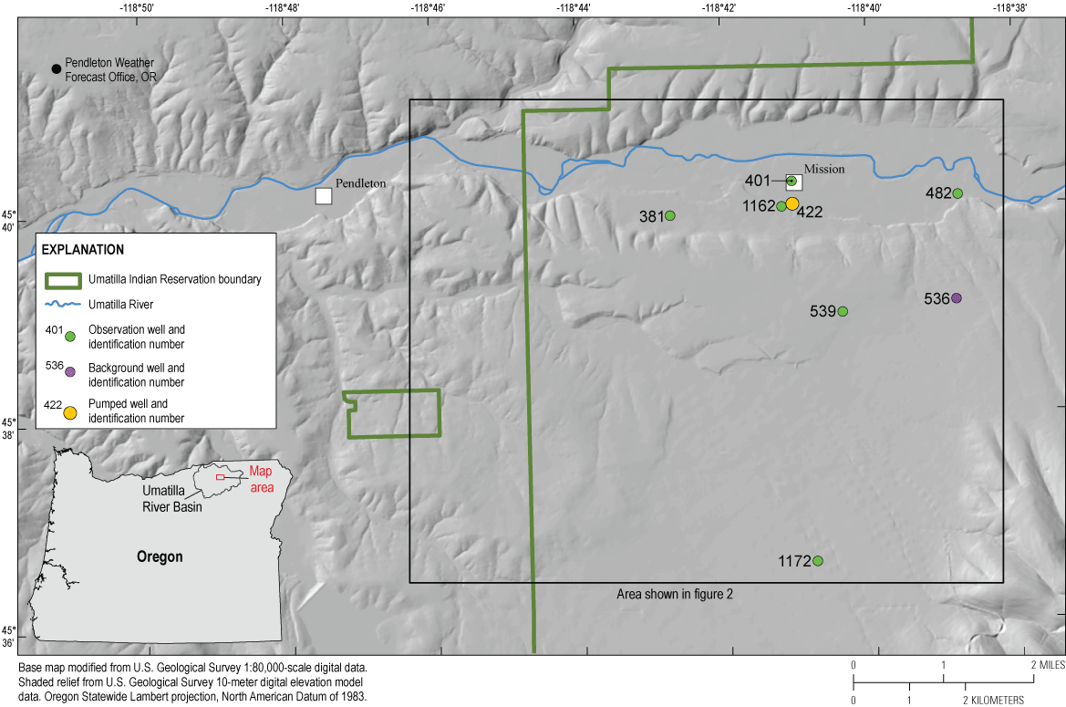
Locations of pumping, observation, and background wells, Umatilla Indian Reservation near Mission, northeastern Oregon, 2016.
During aquifer testing of well 422, continuous water-level data were collected from the pumping well and from seven observation wells drilled within 4 miles (mi) of the pumping well (fig. 1) by personnel from CTUIR, Anderson Perry and Associates, Equipment Technology and Design, Inc., Purswell Pump, and the City of Pendleton Public Works Department. Pumping responses in observation wells were monitored in basalt intervals that were similar to and vertically separated from the pumped intervals. Data collection, water-level modeling, and pumping-response estimates for the well-422 aquifer test are summarized in this report and provided in Garcia and Ely (2024).
Description of Monitoring Network
Groundwater levels from the pumping well and seven nearby observation wells monitored by CTUIR were analyzed for this report. The pumping and observation wells are near the western boundary of the Umatilla Indian Reservation (fig. 1). Observation wells are wells instrumented to record potential water-level changes during aquifer testing. A single observation well was selected and used as a background well to monitor background water-level changes for the multiple-well aquifer test analyses. A background well is distant from the pumping well and is assumed to be unaffected by aquifer testing. Well 536 was selected as the background well because a portion of its open interval is coincident with the pumping well open interval but it did not exhibit a hydrologic response to pumping, and the water-level record in well 536 spanned both constant-rate pumping periods. Although well 1172 is farthest from the pumping well, it was not used as a background well because water-level data were not available during the full intermittent pumping period. Site information for the pumping well, the six observation wells, and the background well are shown in table 1. Well construction information for pumping, observation, and background wells monitored during the aquifer testing are shown in table 2. Construction information was obtained primarily from water well reports on file with Oregon Water Resources Department (OWRD, 2022) and the U.S. Geological Survey National Water Information System database (U.S. Geological Survey, 2022).
Table 1.
Site information for wells monitored during the multiple-well aquifer test, Umatilla Indian Reservation near Mission, northeastern Oregon, 2016.[Location of wells is shown in figure 1. Latitude and longitude coordinates referenced to North American Datum of 1983. Abbreviations: CTUIR, Confederated Tribes of the Umatilla Indian Reservation; ID No., identification number; OWRD, Oregon Water Resources Department; USGS, U.S. Geological Survey; —, not available]
Table 2.
Site information and well construction for wells monitored during the multiple-well aquifer test, Umatilla Indian Reservation near Mission, northeastern Oregon, 2016.[Location of wells is shown in figure 1. Land-surface elevation referenced to North American Vertical Datum of 1988. Bottom hole depth: depth to the base of the well. Open-interval elevation: elevation of the top and bottom of openings in well. The openings may be open hole, perforated, or screened intervals in well casing. Hydrogeologic unit: units adjacent to the well open interval as described in Herrera and others (2017) and water well reports on file with Oregon Water Resources Department (OWRD, 2022). Top of basalt dip angle: computed as the arctangent of the absolute value of the difference between pumping and observation well top of basalt elevation divided by the distance between pumping and observation well. Abbreviations: bls, below land surface; CTUIR, Confederated Tribes of the Umatilla Indian Reservation; ID No., identification number; NA, not applicable; CRBG, Columbia River Basalt Group; S, sediment]
Hydrogeology
The Umatilla Indian Reservation is in the Blue Mountains and lies within the Columbia River flood-basalt province. The Reservation is underlain by a thick sequence of Miocene-age volcanic flood basalts that collectively make up the Columbia River Basalt Group (CRBG) (Hogenson, 1964). Within the study area, the CRBG is overlain in places by less than 200 ft of late-Miocene to early-Pliocene sediments assigned to the McKay Formation and by less than 30 ft of Quaternary alluvium; collectively, these sedimentary units are referred hereinafter as sediment (fig. 2).
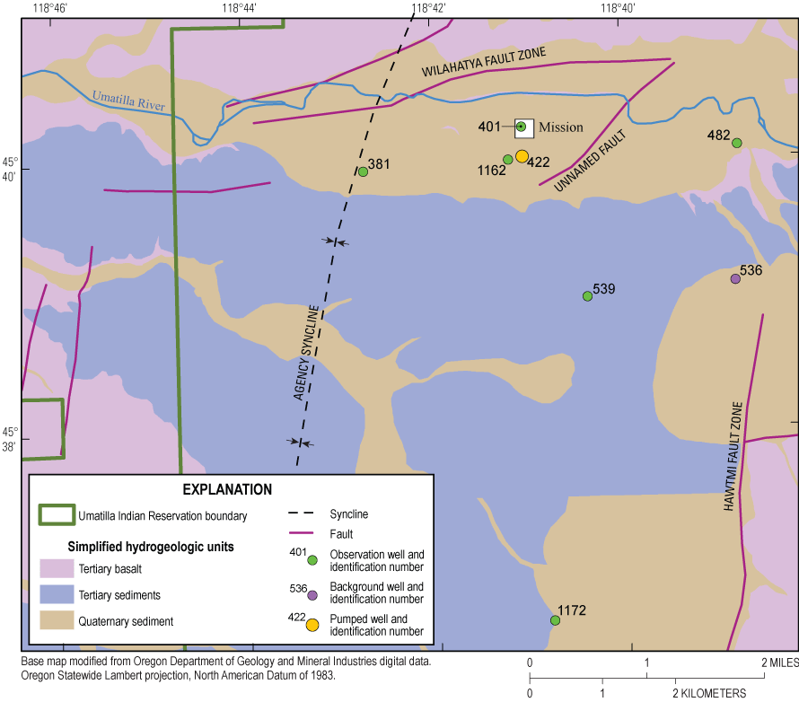
Geology in the area surrounding pumping, observation, and background wells, Umatilla Indian Reservation near Mission, northeastern Oregon.
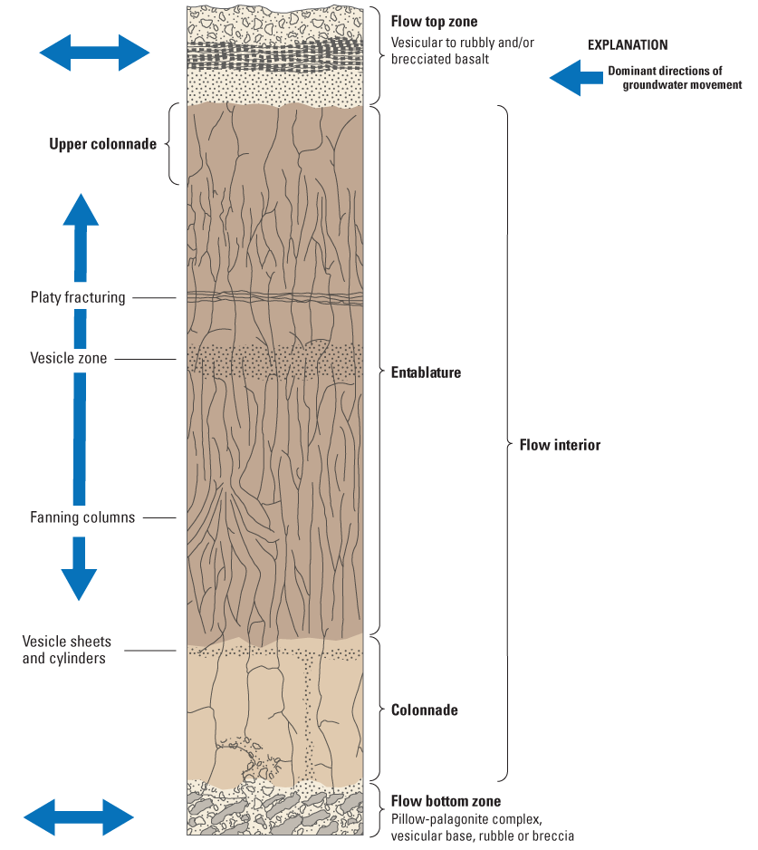
All wells monitored during the multiple-well aquifer test were completed in basalts of the CRBG. The CRBG includes hundreds of layered lava flows of variable thickness, erupted during various stages of the Miocene Age (Tolan and others, 1989; Drost and others, 1990). Permeability within individual lava flows varies widely. The CRBG lava flows typically include a permeable flow top; a dense, low permeability flow interior; and a flow bottom of variable thickness (Reidel and others, 2002) (fig. 3).
A Columbia River Basalt Group flow depicting the typical features. From Kahle and others (2011), modified from Reidel and others (2002).
Ferns and Ely (2006) noted that the CRBG units southeast of the study area display a pronounced downward northwest dip that steepens to the northwest into the Wilahatya fault zone (fig. 2). A comparison of top of basalt elevations between observation (or background) wells and the pumping well supports the presence of dipping units in the study area. The top of basalt exhibits a downward dip of 3–9 degrees toward the pumping well from wells at higher elevation to the south and east. The top of basalt exhibits a downward dip of 9–12 degrees away from the pumping well and toward wells to the north and east (fig. 4).
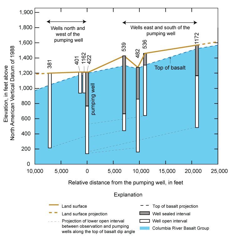
Well construction, top of basalt, and relative distance from the pumping well, Umatilla Indian Reservation near Mission, northeastern Oregon. Relative distances represent the horizontal distance between individual observation wells and the pumping well; distances between observation wells are arbitrary and do not reflect the actual distance between wells. The top of basalt represents the uppermost occurrence of basalt encountered at each well.
The pumping well (well 422) open interval is about 600-ft thick and observation-well open intervals within the CRBG range from about 200-ft (wells 539 and 401) to more than 800-ft thick (well 381) (table 2). Open intervals of wells 1162 and 401, within 1,330 ft of the pumping well, are offset and shallower than the pumping well open interval and could be adjacent to zones with differing permeability than the zone adjacent to the pumping well (table 2; figs. 3, 4). Open intervals in more distant observation wells to the west, south, and east overlap with the pumping well open interval, but the layered basalt units likely dip downward toward the northwest, similar to the top of basalt. Projection of the observed top of basalt dip indicates that the open intervals of wells 381, 539, and 536 generally correspond with the upper 400 ft of the pumping well open interval. Likewise, open intervals of wells 482 and 1172 correspond with the full 600-ft open interval of the pumping well (table 2; fig. 4).
Data Collection
The aquifer test occurred intermittently during February 1–April 18, 2016. Data collected from the pumping well, observation wells, and background well are published in Garcia and Ely (2024). Although pumping was intermittent, observational data were measured continuously and include (1) pumping rates at the pumping well; (2) water levels at the pumping well, six observation wells, and background well (table 1); and (3) barometric pressure at the Pendleton weather forecast office (fig. 1).
Pumping Well
The aquifer-test schedule for pumping well 422 is summarized in table 3 and figure 5. The roughly 600-ft open interval of the pumping well produces water from the CRBG (table 2). The aquifer test included two constant-rate pumping periods (1) from March 9, 2016, at 0800 to March 18, 2016, at 1458 and (2) from April 7, 2016, at 1558 to April 13, 2016, at 1658. The first constant-rate pumping period lasted about 223 hours at an average rate of 466 gallons per minute (gal/min), with a total withdrawal of 6.2 million gallons (Mgal) (table 3). The second constant-rate pumping period lasted about 145 hours at an average rate of 542 gal/min, with a total withdrawal of 4.7 Mgal. Total discharge during the aquifer test, including constant-rate and intermittent pumping periods was about 12.9 Mgal.
Table 3.
Aquifer-test schedule, Umatilla Indian Reservation near Mission, northeastern Oregon, February 1–April 18, 2016.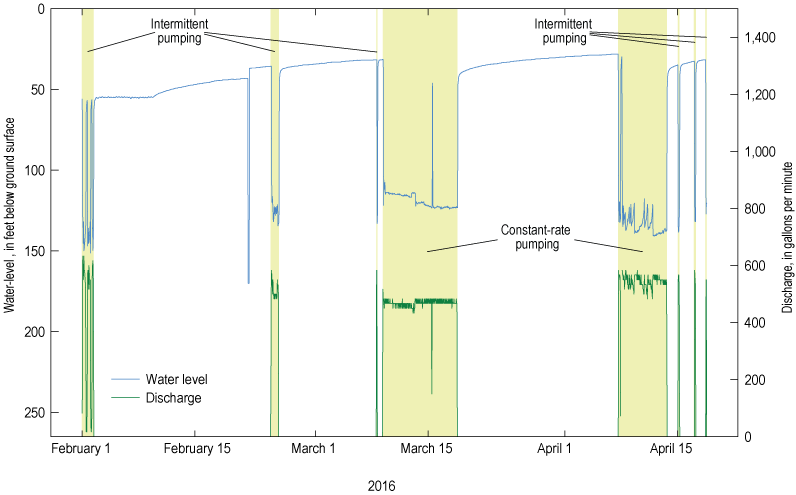
Discharge from and water-level change in pumping well 422 during intermittent and constant-rate pumping, Umatilla Indian Reservation near Mission, northeastern Oregon, February–April 2016. Water-level change refers to measured water-level fluctuations during the period shown.
Observation Wells
Observation wells are in four azimuthal quadrants around pumping well 422 (fig. 1). The horizontal distance between pumping and observation wells ranged from 536 to 21,000 ft (table 2). Water-level response during the aquifer test was analyzed using data from observation wells 381, 401, 482, 539, 1162, and 1172 and background well 536 (fig. 1). All wells are open to the CRBG over intervals ranging from about 200 to more than 800 ft. Well 381 also is open to about 90 ft of sediments overlaying the CRBG.
Water-Level Modeling and Pumping Response Estimation
Pumping responses were estimated in pumping and observation wells using analytical water-level models (Halford and others, 2012; Garcia and others, 2013). Environmental fluctuations caused by barometric pressure and other natural forces on the aquifer system can obscure aquifer responses to anthropogenic stresses such as pumping. Natural recharge can cause long-term rises and declines in water levels that are superimposed on short-term fluctuations from pumping (Fenelon, 2000; Elliott and Fenelon, 2010). Water-level modeling provides a mechanism for distinguishing environmental fluctuations from anthropogenic stresses in hydrogeologic systems and improving aquifer-test interpretations (Halford and others, 2012; Garcia and others, 2013).
Water-level models analytically simulate all anthropogenic and environmental stresses simultaneously during the period of aquifer-test data collection, which allows for the isolation of pumping stresses. Environmental water-level fluctuations were simulated with time series of barometric pressure, earth and gravity tides, and water levels from background well 536. Background well 536 was assumed to be close enough to the observations wells to be affected by similar environmental fluctuations yet did not exhibit a response to pumping from well 422. Water levels from the background well were critical because they exhibit seasonal water-level trends and other environmental fluctuations. These trends and fluctuations also were assumed to be present in the observation wells.
Pumping responses were simulated with Theis models (Halford and others, 2012). Theis (1935) modeled approximated anthropogenic signals such as pumping by transforming time-varying pumping schedules from pumping wells into water-level changes. Theis models were generated from simplified pumping schedules to eliminate small pumping-rate fluctuations that minimally affect distant water levels. Simplified pumping schedules were considered acceptable for observation wells in this study because the aquifer responses to high-frequency changes in pumping were attenuated by the aquifers and generally not detectable in the nearby observation wells (Garcia and others, 2013).
Analytically simulated water levels, which are the sum of all simulated stresses in the water-level model, were fit to measured water levels by minimizing the root-mean-square (RMS) error of differences between the analytically simulated and measured time series (Halford and others, 2012). The amplitude and phase of the hydrograph were adjusted in each time series that simulated environmental water-level fluctuations. Transmissivity and storage coefficient were adjusted to provide the best fit of simulated and measured water levels in the Theis models. Although Theis models were valid for estimating pumping responses, estimated values of transmissivity and storage coefficient from the Theis model generally were not valid estimates of aquifer properties because the assumptions of the underlying Theis solution were violated. Water-level change estimates are the summation of Theis models minus differences between simulated and measured water levels (residuals). Residuals represent all unexplained water-level fluctuations, during pumping and non-pumping periods.
Pumping responses in observation wells were classified as “not detected,” “detected,” or “ambiguous” based on the signal-to-noise ratio (Garcia and others, 2013) and other factors. Signal and noise are defined herein as the maximum drawdown occurring in a well during an aquifer test and the RMS error, respectively. Pumping responses were classified as not detected where the signal-to-noise ratio was less than 5, indicating drawdown could not be reliably differentiated from the noise. Pumping responses were classified as detected where the signal-to-noise ratio was greater than or equal to 10 and drawdown was greater than a detection threshold of 0.05 ft. Pumping responses were classified as ambiguous when the detection was less than a threshold of 0.05 ft, the signal-to-noise ratio ranged from 5 to 10, or because of likely correlation between pumping and environmental fluctuations. Correlation between environmental fluctuations and the pumping signal becomes apparent where drawdown can be approximated by a linear trend during all or part of the period of analysis. Correlation typically is possible as aquifer properties limit signal propagation through the aquifer, distance between observation and pumping well increases, or recovery is truncated.
Aquifer Test
Water-level changes resulting from pumping were approximated using simplified pumping steps. Pumping steps used to generate Theis models were simplified from the reported pumping rates of well 422 to 303 generalized steps (fig. 6). These generalized steps were sufficient to adequately calculate the pumping response in near and distant observation wells with Theis models. Simulated water levels summed applicable time series of barometric pressure from the Pendleton Weather Forecast Office, background water levels, and pumping responses.
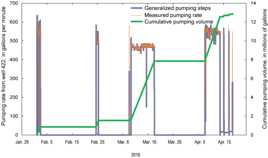
Pumping rate from well 422, Umatilla Indian Reservation near Mission, northeastern Oregon, February–April 2016. Measured pumping rates were generalized into 303 pumping steps for use in Theis models.
Pumping Response Detection
Simulated water levels matched measured water levels with RMS errors from 0.027 to 0.086 ft in observation and background wells and 2.63 ft in the pumping well. Excluding the pumping well, maximum drawdown estimates in analyzed wells were relatively large where detected (greater than 7.5 ft) in two wells and small (0.6 ft) in one well where pumping response detection was ambiguous (table 4). In the remaining four wells, a pumping response was not detected and the fit between simulated and measured water levels improved when pumping was excluded from water-level models.
Table 4.
Pumping response detection and maximum drawdown estimates in pumping, observation, and background wells from aquifer testing, Umatilla Indian Reservation near Mission, northeastern Oregon, February–April 2016.[Location of wells is shown in figure 1. Maximum drawdown was estimated by matching measured water levels in the observation well to a simulated curve of non-pumping and pumping responses. Abbreviations: CTUIR, Confederated Tribes of the Umatilla Indian Reservation; ID No., identification number; Est max, estimated maximum; RMS, root mean square]
Quality of maximum drawdown estimates, and pumping response detection classifications are illustrated with responses in all observation wells (figs. 7–9). Pumping responses were detected with a high degree of certainty in wells 482 and 539, to the east and south of the pumping well, respectively, because discrete pumping intervals can be discerned, recovery is observed, and the signal-to-noise ratio exceeds 80 (table 4; fig. 7). Pumping response detection in well 381, located west of the pumping well, was ambiguous because the pumping signal is correlated with the multi-day barometric pressure signal and the water-level model fit only slightly improved, from an RMS error of 0.047 to 0.039 ft, when pumping was included (table 4; fig. 8). Worksheets showing fitting parameters, measured and simulated water levels, and pumping response estimates for all wells in table 4 can be viewed in individual water-level model Microsoft Excel files in Garcia and Ely (2024).
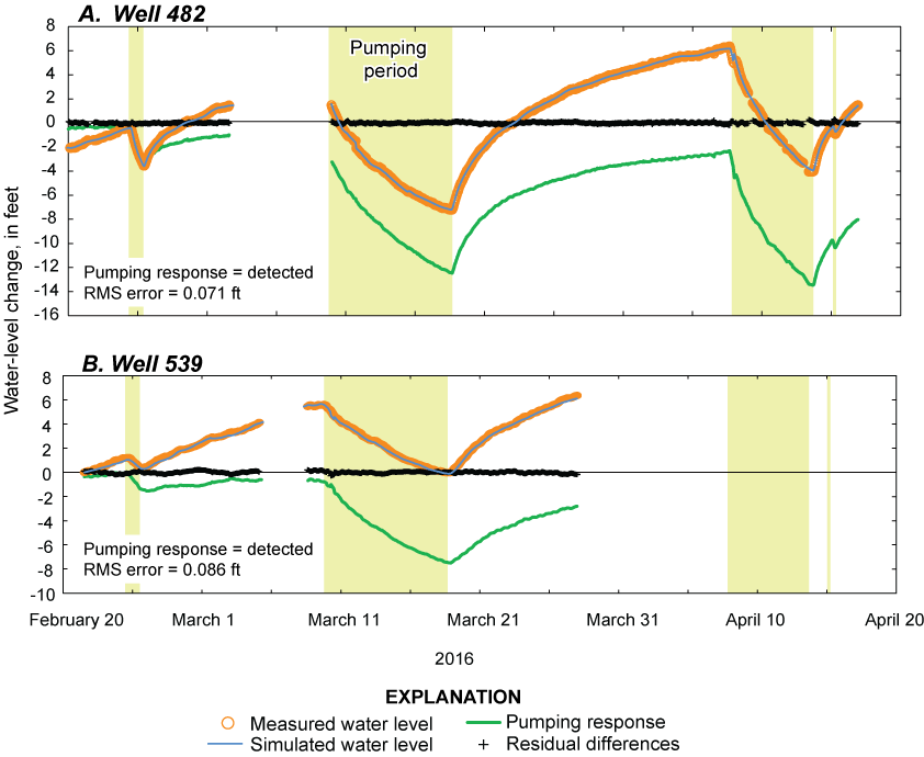
Measured and simulated water levels and pumping response estimates in observation wells A, 482 and B, 539 showing a “detected” response from pumping in well 422, Umatilla Indian Reservation near Mission, northeastern Oregon, February–April 2016. Root-mean-square (RMS) error of the fit between simulated and measured water levels is also provided.
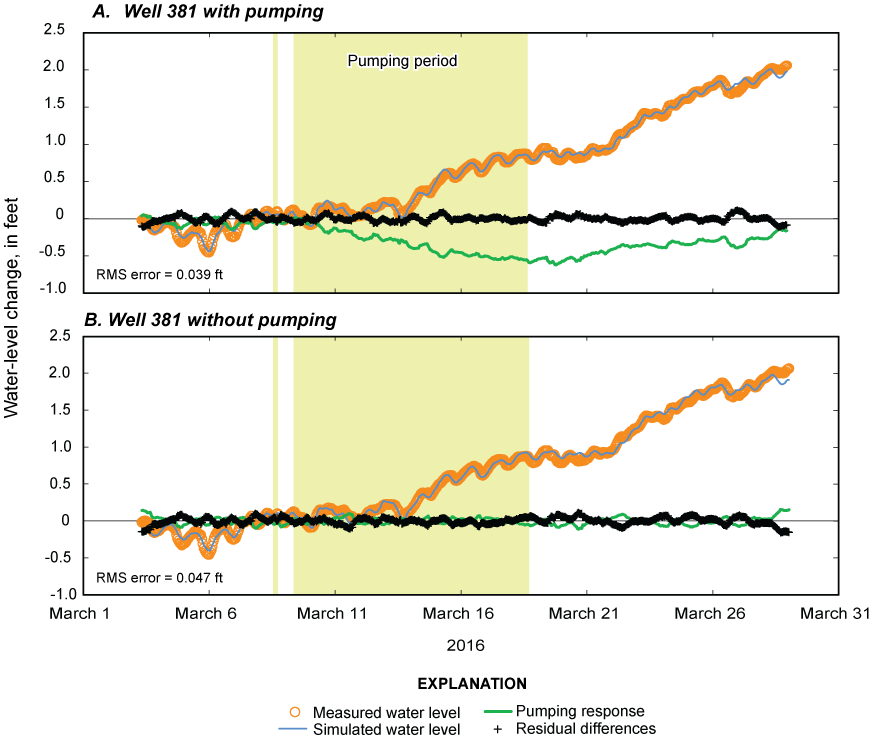
Measured and simulated water levels and pumping response estimates in observation well 381 from pumping in well 422, where pumping response detection was A, ambiguous when pumping was simulated and B, not detected when pumping was not simulated, Umatilla Indian Reservation near Mission, northeastern Oregon, March 2016. Root-mean-square (RMS) error of the fit between simulated and measured water levels is also provided.
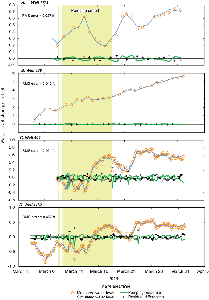
Measured and simulated water levels and pumping response estimates in observation wells A, 1172, B, 536, C, 401, and D, 1162 showing a “not detected” response from pumping in well 422, Umatilla Indian Reservation near Mission, northeastern Oregon, March 2016. Root-mean-square (RMS) error of the fit between simulated and measured water levels is also provided.
Pumping responses were detected 1.8 mi (9,700 ft) to the east and 1.4 mi (7,100 ft) to the south. The largest of the two detected pumping responses was in well 482, which is 0.4 mi farther from the pumping well than well 539 (table 2). Well 482 and the pumping well also are on opposite sides of an unnamed fault (fig. 2). The open-interval elevation of observation well 482 and 530 are coincident with the open-interval elevation of pumping well 422 when projected along the top of basalt dip angle (fig. 4); well 482 is coincident across the full 607-ft-thick pumping-well open interval whereas well 539 is coincident across the upper portion only. Differences in open-interval elevations and pumping responses in observation wells 482 and 539 could indicate basalt permeability varies across the pumping-well open interval, where the lower zone is more permeable than the upper zone or a less permeable zone is attenuating the drawdown signal in well 539. Higher flow rates during well-development testing commonly are indicative of higher permeability. Well-development tests from water-well reports on file with OWRD (2022) indicate that flow rates, and likely permeability, increase with depth in wells 482 and 539 (see table 1 for OWRD well log identification numbers associated with water-well reports).
A detected pumping response across the unnamed fault between well 482 and the pumping well (fig. 2) indicates that a hydraulic connection exists, and the fault minimally affects groundwater flow between the two wells. Ferns and Ely (2006) noted that the east-west trending Wilahatya fault zone (fig. 2) parallels the Umatilla River in the study area, and the fault zone could enhance permeability and connectivity between the pumping well and well 482. Enhanced permeability in the rocks penetrated by well 482 also is supported by well-development tests from water-well reports on-file with OWRD (2022). These well-development tests indicate that well 482 sustained higher pumping rates than well 539 and the pumping well whereas drawdown magnitudes were similar at all wells.
An alternative water-level model was created for well 381 where pumping response detection was ambiguous (table 4; fig. 8B). The assumption that a pumping response was absent was evaluated by excluding Theis models of the pumping signal in the water-level model. The RMS error of the alternative model was greater, but RMS differences between the two models were negligible (fig. 8). The pumping response at well 381 should be interpreted within the range of model estimates, from not detected to no more than 0.6 ft of drawdown.
Attenuation of the pumping signal at well 381 could be related to an offset in permeability zones owing to a steeper dip in basalt, the Agency syncline, or unmapped faults. Well 381 is 7,130 ft downgradient and west of the pumping well and its open-interval elevation is coincident with the mid-to-upper portion of the pumping well open interval if projected along the top of basalt dip angle and is adjacent to the Agency syncline (fig. 2). Although wells 381 and 539 are similar distances from the pumping well and their open-interval elevations overlap, the dip in the top of basalt between the pumping well and well 381 is 4 degrees steeper than the dip between the pumping well and well 539 (table 2; fig. 4). A steeper dip in basalt to the west (relative to the south and east) might offset permeability zones between the pumping well and well 381, reducing connectivity for groundwater flow. In addition (or alternatively), the Agency syncline or unmapped faults could have attenuated the pumping signal between the pumping well and well 381 to the west.
Pumping responses were designated as not detected in wells 1162 and 401 where the open-interval elevations were shallower and had no overlap with the open interval of the pumping well (figs. 4, 9C, D). Wells 1162 and 401 are a short horizontal distance from the pumping well (536 and 1,330 ft, respectively) but showed no quantifiable response to pumping. The open intervals of these two wells do not overlap with the open interval of pumping well 422 or the two observation wells exhibiting clear pumping responses (wells 539 and 482). Water-level fluctuations in these wells were adequately simulated using multiple moving averages of barometric pressure, indicating imperfect barometric coupling between groundwater levels and the atmosphere, but no quantifiable response to pumping in well 422 was estimated. The lack of a quantifiable pumping response in the two shallow basalt observation wells (1162 and 401) indicates poor vertical hydraulic connectivity between shallow and deep basalt in this area, which is typical of thick sequences of CRBG basalt units (Burns and others, 2011; Kahle and others, 2011).
Pumping responses were not detected in distant wells 1172 and 536 despite open-interval elevations that are coincident with the pumping well open interval when projected along the top of basalt dip angle. Well 1172 is 21,000 ft (4 mi) south of the pumping well, with an open interval that fully overlaps with the pumping well. A lack of pumping response detection at well 1172 could be from signal attenuation across 4 mi of aquifer, buried structures, or both. In addition, an attenuated pumping signal would be difficult to distinguish from environmental fluctuations on a daily timestep as was monitored at this well.
Well 536 is 11,100 ft (2 mi) upgradient and southeast of the pumping well and the open-interval elevation is coincident with the upper portion of the pumping-well open interval (fig. 4). The lack of pumping response in well 536 could indicate basalt adjacent to the upper portion of the pumping-well open interval is less permeable than the lower portion or a less permeable zone is attenuating the drawdown signal in well 536 (as was hypothesized for well 539). Well 536 is 1.5 times the distance from the pumping well as well 539, therefore full attenuation of the pumping signal at well 536 is plausible. Additionally, well 536 is within the north-south trending Hawtmi fault zone that might limit east-west signal propagation between well 536 and the pumping well (fig. 2). Finally, like well 1172, an attenuated pumping signal would be difficult to distinguish from environmental fluctuations on a daily timestep.
Summary
The U.S. Geological Survey, in cooperation with Confederated Tribes of the Umatilla Reservation, estimated pumping-related water-level change from a multiple-well aquifer test on the Umatilla Indian Reservation near Mission, northeastern Oregon to improve the understanding of aquifer characteristics and hydrologic flow boundaries. Pumping response estimates in six observation wells and one background well were determined by distinguishing the pumping signal from environmental fluctuations in groundwater levels using analytical water-level models. Pumping well 422 produced water from the Columbia River Basalt Group. Observation and background wells are open to basalt and on the same or opposite sides of structural features.
Pumping responses at observation and background wells were classified as detected in two wells, ambiguous in one well, and not detected in four wells. Pumping responses were detected 1.8 miles (mi) to the east in well 482, across a fault, and 1.4 mi to the south in well 539. The larger pumping response observed for well 482 compared to 539 is attributed to (1) a more permeable zone open to deeper portions of well 482 and the pumping well, but beneath well 539, and (or) (2) enhanced permeability and connectivity along the Wilahatya fault zone that parallels the area between well 482 and the pumping well.
The pumping response was characterized as ambiguous in well 381, located 1.4 mi west and downgradient of the pumping well and adjacent to the Agency syncline. The response in well 381 was classified as ambiguous because the small potential pumping signal is correlated with the multi-day barometric pressure signal. The possible pumping response should be interpreted within the range of estimates, from not detected to no more than 0.6 ft of drawdown. Little to no pumping response to the west of the pumping well indicates that the pumping signal was either attenuated by the Agency syncline, a less permeable zone open to the upper portion of the pumping well and well 381, unmapped faults, or a combination of these.
The pumping response was designated as not detected in wells 401, 1162, 1172, and 536. Wells 401 and 1162 are within 0.3 mi of the pumping well but their open-interval elevations are above and do not overlap with the open interval of the pumping well. A non-detected pumping response in the two nearby observation wells indicates that a low-permeability zone likely limits vertical hydraulic connectivity between the basalt open to wells 401 and 1162 and the deeper pumping well. Open-interval elevations in wells 1172 and 536 overlap with the open interval of the pumping well but the wells are 2 to 4 mi from the pumping well. A lack of response detection in these wells is likely from signal attenuation over long distances, across less permeable zones, and (or) from the Hawtmi fault zone and unmapped structures, and a lack of data points from a daily monitoring time step.
References Cited
Burns, E.R., Morgan, D.S., Peavler, R.S., and Kahle, S.C., 2011, Three-dimensional model of the geologic framework for the Columbia Plateau Regional Aquifer System, Idaho, Oregon, and Washington: U.S. Geological Survey Scientific Investigations Report 2010–5246, 44 p., accessed August 17, 2023, at https://doi.org/10.3133/sir20105246.
Drost, B.W., Whiteman, K.J., and Gonthier, J.B., 1990, Geologic framework of the Columbia Plateau Aquifer System, Washington, Oregon, and Idaho: U.S. Geological Survey Water-Resources Investigations Report 87–4238, 10 p., accessed August 17, 2023, at https://doi.org/10.3133/wri874238.
Elliott, P.E., and Fenelon, J.M., 2010, Database of groundwater levels and hydrograph descriptions for the Nevada Test Site area, Nye County, Nevada (ver. 5.0, February 2022): U.S. Geological Survey Data Series 533, 16 p., accessed August 17, 2023, at https://doi.org/10.5066/F75H7FGN.
Fenelon, J.M., 2000, Quality assurance and analysis of water levels in wells on Pahute Mesa and vicinity, Nevada Test Site, Nye County, Nevada: U.S. Geological Survey Water-Resources Investigations Report 2000–4014, 68 p., accessed August 17, 2023, at https://doi.org/10.3133/wri004014.
Ferns, M.L., and Ely, K., 2006, Preliminary geologic map of the Mission 7.5’ quadrangle, Umatilla County, Oregon: Oregon Department of Geology and Mineral Industries Open-File Report O-06-09, 9 p., accessed August 17, 2023, at https://digital.osl.state.or.us/islandora/object/osl%3A72383/datastream/OBJ/view.
Garcia, C.A., Halford, K.J., and Fenelon, J.M., 2013, Detecting drawdowns masked by environmental stresses with water-level models: Ground Water, v. 51, no. 3, p. 322–332, accessed August 17, 2023, at https://doi.org/10.1111/gwat.12042.
Garcia, C.A., and Ely, K., 2024, Multiple-well aquifer-test data and results, Umatilla Indian Reservation near Mission, northeastern Oregon: U.S. Geological Survey data release, https://doi.org/10.5066/P9Q1122I.
Halford, K., Garcia, C.A., Fenelon, J., and Mirus, B., 2012, Advanced methods for modeling water-levels and estimating drawdowns with SeriesSEE, an Excel add-in, (ver. 1.2, July 2016): U.S. Geological Survey Techniques and Methods 4–F4, 28 p., accessed August 17, 2023, at https://doi.org/10.3133/tm4F4.
Herrera, N.B., Ely, K., Mehta, S., Stonewall, A.J., Risley, J.C., Hinkle, S.R., and Conlon, T.D., 2017, Hydrogeologic framework and selected components of the groundwater budget for the upper Umatilla River Basin, Oregon: U.S. Geological Survey Scientific Investigations Report 2017–5020, 57 p., accessed August 17, 2023, at https://doi.org/10.3133/sir20175020.
Hogenson, G.M., 1964, Geology and ground water of the Umatilla River Basin, Oregon: U.S. Geological Survey Water-Supply Paper 1620, 162 p., accessed August 17, 2023, at https://doi.org/10.3133/wsp1620.
Kahle, S.C., Morgan, D.S., Welch, W.B., Ely, D.M., Hinkle, S.R., Vaccaro, J.J., and Orzol, L.L., 2011, Hydrogeologic framework and hydrologic budget components of the Columbia Plateau regional aquifer system, Washington, Oregon, and Idaho: U.S. Geological Survey Scientific Investigations Report 2011–5124, 63 p., accessed August 17, 2023, at https://doi.org/10.3133/sir20115124.
Oregon Water Resources Department [OWRD], 2022, Groundwater information system: Oregon Water Resources Department database, accessed December 12, 2022, at https://apps.wrd.state.or.us/apps/gw/gw_info/gw_info_report/Default.aspx.
Reidel, S.P., Johnson, V.G., and Spane, F.A., 2002, Natural gas storage in basalt aquifers of the Columbia Basin, Pacific Northwest USA—A guide to site characterization: Richland, Wash., Pacific Northwest National Laboratory, 277 p., accessed August 16, 2023, at http://www.pnl.gov/main/publications/external/technical_reports/PNNL-13962.pdf.
Theis, C.V., 1935, The relation between the lowering of the piezometric surface and the rate and duration of discharge of a well using ground-water storage: Eos, v. 16, no. 2, p. 519–524, accessed August 17, 2023, at https://doi.org/10.1029/TR016i002p00519.
Tolan, T.L., Reidel, S.P., Beeson, M.H., Anderson, J.L., Fecht, K.R., and Swanson, D.A., 1989, Revisions to the estimates of the areal extent and volume of the Columbia River Basalt Group, in Reidel, S.P., and Hooper, P.R., eds., Volcanism and tectonism in the Columbia River flood-basalt province: Geological Society of America Special Paper 239, p. 1–20, accessed August 17, 2023, at https://doi.org/10.1130/SPE239-p1.
U.S. Geological Survey, 2022, USGS water data for the Nation: U.S. Geological Survey National Water Information System database, accessed August 17, 2023, at https://doi.org/10.5066/F7P55KJN.
Conversion Factors
U.S. customary units to International System of Units
Datums
Vertical coordinate information is referenced to the North American Vertical Datum of 1988 (NAVD 88).
Horizontal coordinate information is referenced to the North American Datum of 1983 (NAD 83).
Altitude, as used in this report, refers to distance above the vertical datum.
For more information about the research in this report, contact
Director, Oregon Water Science Center
U.S. Geological Survey
601 SW 2nd Avenue, Suite 1950
Portland, OR 97204
https://www.usgs.gov/centers/oregon-water-science-center
Manuscript approved on October 3, 2023
Publishing support provided by the U.S. Geological Survey
Science Publishing Network, Tacoma Publishing Service Center
Disclaimers
Any use of trade, firm, or product names is for descriptive purposes only and does not imply endorsement by the U.S. Government.
Although this information product, for the most part, is in the public domain, it also may contain copyrighted materials as noted in the text. Permission to reproduce copyrighted items must be secured from the copyright owner.
Suggested Citation
Garcia, C.A., Kennedy, J.J., and Ely, K., 2024, Water-level change from a multiple-well aquifer test in volcanic rocks, Umatilla Indian Reservation near Mission, northeastern Oregon, 2016: U.S. Geological Survey Open-File Report 2023–1081, 16 p., https://doi.org/10.3133/ofr20231081.
ISSN: 2331-1258 (online)
Study Area
| Publication type | Report |
|---|---|
| Publication Subtype | USGS Numbered Series |
| Title | Water-level change from a multiple-well aquifer test in volcanic rocks, Umatilla Indian Reservation near Mission, northeastern Oregon, 2016 |
| Series title | Open-File Report |
| Series number | 2023-1081 |
| DOI | 10.3133/ofr20231081 |
| Publication Date | January 18, 2024 |
| Year Published | 2024 |
| Language | English |
| Publisher | U.S. Geological Survey |
| Publisher location | Reston, VA |
| Contributing office(s) | Oregon Water Science Center |
| Description | Report: vii, 16 p.; Data Release |
| Country | United States |
| State | Oregon |
| Other Geospatial | Umatilla Indian Reservation |
| Online Only (Y/N) | Y |