

Triangle Area Water Supply Monitoring Project, North Carolina—Overview of Hydrologic and Water-Quality Monitoring Activities and Data Quality Assurance
Links
- Document: Report (1.42 MB pdf) , HTML , XML
- Data Release: USGS Data Release - Associated data for the Triangle Area Water Supply Monitoring Project, North Carolina, October 2019–September 2022
- NGMDB Index Page: National Geologic Map Database Index Page (html)
- Download citation as: RIS | Dublin Core
Acknowledgments
The authors thank the many local government partners for their collaboration and support of the Triangle Area Water Supply Monitoring Project.
The authors also would like to express sincere gratitude to Ryan Rasmussen, Cassandra Pfeifle, Eric Von Amsberg, and Michelle Morency at the U.S. Geological Survey South Atlantic Water Science Center, Raleigh Office, for their invaluable assistance in water-quality sample collections, data management support, or technical assistance with report preparation.
Abstract
Surface-water supplies are important sources of drinking water for residents in the Triangle area of North Carolina, which is located within the upper Cape Fear and Neuse River Basins. Since 1988, the U.S. Geological Survey and a consortium of local governments have participated in a cooperative effort, known as the Triangle Area Water Supply Monitoring Project, to track water-quality and quantity conditions in several of the area’s water-supply reservoirs and streams. This report summarizes the hydrologic and water-quality monitoring activities through this cooperative effort, including an overview of previous and current data collection and quality-assurance and quality-control activities.
Introduction
The Triangle area, located within the upper Cape Fear and Neuse River Basins, is one of the most rapidly developing areas of North Carolina (fig. 1). The region has undergone, and continues to undergo, profound increases in population and land use change, which increases the demand on drinking water supplies drawn from streams and surface reservoirs. From 2010 to 2020, population in Chatham, Durham, Orange, and Wake Counties increased 21 percent (from 1,368,231 to 1,649,011 persons), with a projected population increase of another 34 percent in the same 4 counties by 2040 (North Carolina Office of State Budget and Management, 2021). Population growth not only increases drinking water demand, but it also increases water-supply vulnerability. From 2001 to 2019, the total amount of urban land cover in Chatham, Durham, Orange, and Wake Counties increased by about 21 percent (Wickham and others, 2023). Development to accommodate growing populations can increase nutrient and sediment loading in streams and rivers, can increase wastewater discharge volumes, and can also add contaminant sources like industrial facilities to the landscape. If not properly managed and mitigated, these variables could adversely affect water quality.
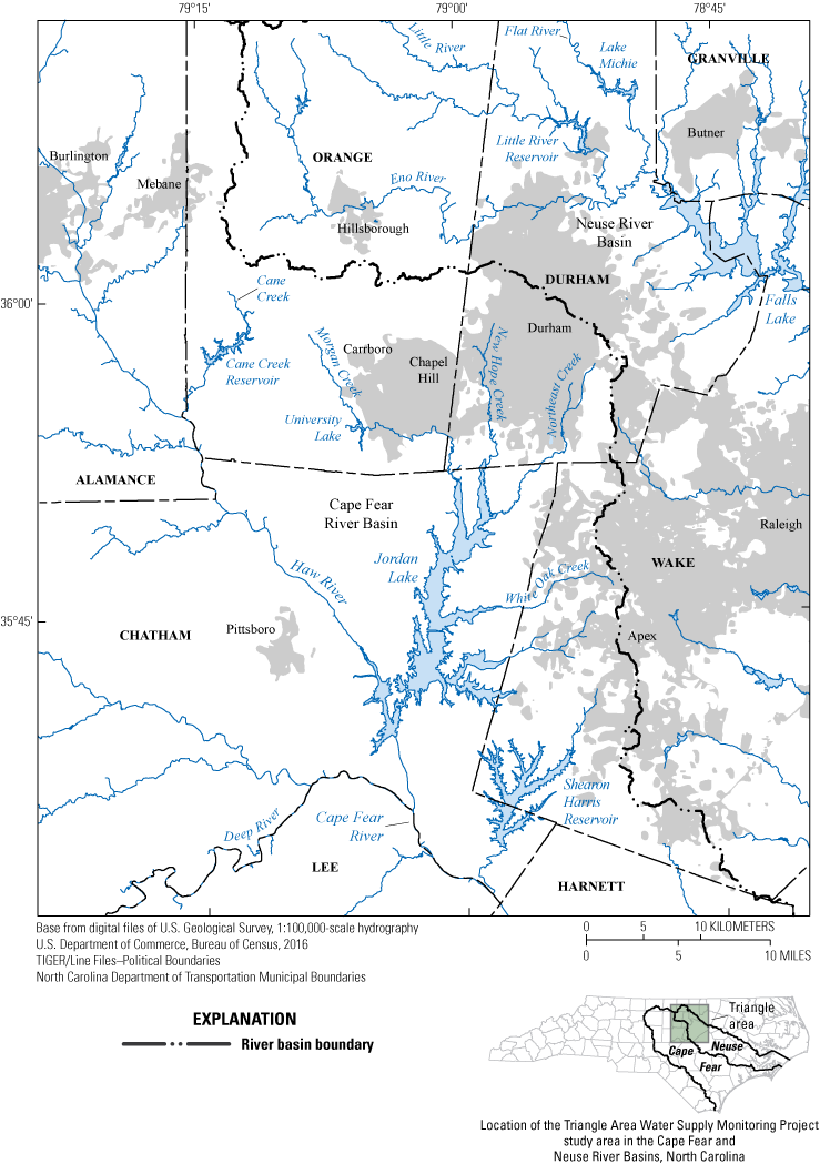
Location of the Triangle Area Water Supply Monitoring Project study area in the Cape Fear and Neuse River Basins, North Carolina.
Municipal suppliers obtain raw water from reservoirs and rivers in the Triangle area, which encompasses the area between the cities of Raleigh, Durham, and Chapel Hill, N.C. (fig. 1). All surface waters in the study area are designated as “nutrient sensitive,” meaning these waters are particularly vulnerable to excessive algal growth from elevated nutrient inputs (North Carolina Department of Environmental Quality [NCDEQ], 2023a). Although some of these streams have high-quality water and are designated as such (for example, the Eno River located in the Neuse River Basin), several streams in the Triangle area are listed as impaired on the North Carolina 303(d) list. This list originates from Section 303(d) of the Federal Clean Water Act and requires States to identify a significance ranking for waterbodies based on water-quality standards and total maximum daily loads. These impaired streams (such as Northeast Creek located in the Cape Fear River Basin) are listed due to poor biological integrity, low dissolved oxygen, high turbidity, and excessive fecal coliform bacteria (NCDEQ, 2023b).
Recognizing the potential effects of population growth and landscape change on water-supply quality and quantity, local governments have committed to long-term monitoring and assessment to protect the area’s water-supply resources. In 1988, several local governments joined to form the Triangle Area Water Supply Monitoring Project (TAWSMP) to systematically evaluate the quality of water-supply sources in the region. The U.S. Geological Survey (USGS) has worked in cooperation with the TAWSMP for more than 30 years to collect and analyze water-quality samples from reservoirs and streams and continuous records of streamflow in the study area. Data collected by the USGS, the NCDEQ, cooperative programs between the USGS and the U.S. Army Corps of Engineers (USACE), the Upper Cape Fear River Basin Association, and other local governments help to form a long-term, comprehensive dataset of water-quality and streamflow information for the Triangle area.
The TAWSMP has progressed in phases (as described below in the “Project History” section), allowing for flexibility in the monitoring network and partner membership and for timely response to emerging water-quality concerns. The primary objectives of the project are as follows:
-
• Extend the existing long-term water-quality dataset for selected parameters and analytes to track spatial variations in water quality, loads to reservoirs, and long-term water-quality trends;
-
• Continue monitoring at tributary sites during high-flow events to increase the understanding of constituent concentrations and loads during extreme hydrologic conditions;
-
• Maintain a network of continuous streamgages in the study area; and
-
• Investigate the occurrence and distribution of water-quality parameters based on historical data.
Pursuant to an agreement with the TAWSMP partners, the USGS monitors hydrologic conditions and collects water-quality samples within the Triangle area. Continuous streamflow is recorded at most of the stream sites and is funded through the TAWSMP and other USGS programs. The USGS is responsible for data quality-assurance, analysis, and interpretation; providing the data to the public; and maintaining the USGS National Water Information System (NWIS) database (USGS, 2023) in perpetuity. Additional water-quality data from various Federal, State, and local agencies can be found in the Water Quality Portal (National Water Quality Monitoring Council, 2023; https://www.waterqualitydata.us). Funding for the project is provided by local government partners (see sidebar) and by the USGS. Further information about funding can be found on the USGS Water Resources site (https://www.usgs.gov/mission-areas/water-resources/science/usgs-cooperative-matching-funds?qt-science_center_objects=0#qt-science_center_objects). The Triangle J Council of Governments provides organizational support services for the TAWSMP.
Triangle Area Water Supply Monitoring Project Partners
Chatham County
Orange County
Town of Apex
Town of Cary
City of Durham
Town of Hillsborough
Town of Morrisville
Orange Water and Sewer Authority
Triangle J Council of Governments
U.S. Geological Survey
Town of Pittsboro (1988–92)
City of Raleigh (1988–95, 2005–11)
Town of Sanford (1988–99)
Town of Smithfield (1988–95)
South Granville Water and Sewer Authority (2007–11)
For more information on the project, go to https://tawsmp.org/ or https://www.usgs.gov/centers/sawsc/science/triangle-area-nc-water-supply-monitoring.
Project History
Although the objectives of the TAWSMP have remained the same since the project began in 1988, several adjustments in project scope have been made to sampling locations, sampling frequency, and measured constituents to adapt to changing partner needs. In addition to the primary objectives previously listed, each phase of the project has had a distinctive supplemental area of focus. Historical sampling site locations that have been discontinued during the course of the TAWSMP are described in Oblinger (2004).
Phase I of the project (October 1988–September 1991) focused on classifying the occurrence of synthetic organic compounds at the sampling locations and in Haw River bed sediments. The project initially consisted of 31 sampling sites; the USGS sampled 17 sites, and the NCDEQ, formerly the North Carolina Department of Environment and Natural Resources, Division of Water Quality, sampled 14 sites. The routine sampling frequency for all reservoir sites was five times annually (April, June, August, September, and October) and once monthly for all stream sites. Measurements of streamflow were also routinely collected at selected stream locations. Routine sample collection and streamflow measurements were continued during all phases of the TAWSMP. Lake Benson, Jordan Lake above U.S. Hwy 64, and Swift Creek near Apex were added to the network in 1991 (Oblinger, 2004).
Phase II (October 1991–September 1995) focused on determining sources of pesticides detected in phase I. Several site adjustments were made: Flat River near Bahama, Little River near Fairntosh, and Jordan Lake at Buoys 7 and 9 were discontinued, and Jordan Lake at Buoy 12 and Deep River at Carbonton were added to the network. A USGS Open-File Report (OFR) summarized the water-quality data collected in the TAWSMP study area from 1988 to 1992 (Garrett and others, 1994). A Water-Resources Investigations Report (WRIR) was published describing water and bed-material quality, summary statistics, annual loads and yields, and streamflow conditions of selected streams and reservoirs for the Triangle area for data from 1988 to 1994 (Childress and Treece, 1996). An additional WRIR was published presenting the results of a trends analysis for selected constituents and parameters in the TAWSMP study area for the period 1983–95 (Childress and Bathala, 1997). This water-quality trends report describes data collected by the USGS from 1982 to 1987 for a USACE study. The WRIR also includes data collected by the North Carolina Department of Environment and Natural Resources, Division of Water Quality, from 1982 to 1995 for the statewide ambient water-quality monitoring network, as well as data from the USGS for the TAWSMP from 1988 to 1995 (Childress and Bathala, 1997).
Phase III (October 1995–June 1999) focused on the occurrence of Cryptosporidium parvum oocytes and Giardia lamblia cysts in water supplies and the collection of high-flow samples. The City of Raleigh and the Town of Smithfield withdrew their participation in the TAWSMP; consequently, multiple sites were discontinued from the monitoring network, including all sites in or downstream from Falls Lake, Jordan Lake at Bells Landing, and Deep River at Carbonton (Oblinger, 2004). The routine sampling collection was reduced to semimonthly for stream sites and four times per year for reservoir sites. Water-quality samples during high-flow events were included in sample collection.
Phase IV (July 1999–June 2003) focused on storm-runoff event samples to provide data for estimating load concentrations. White Oak Creek is a tributary to Jordan Lake, and White Oak Creek at Green Level was added to the network. Jordan Lake at Bells Landing was returned to the network. The collection and analysis of iron, manganese, and nutrients at multiple depths were added for the reservoir sampling sites. An OFR was published to document laboratory and data-collection methods, sample processing, streamflow-measurement procedures, record management, and quality-assurance and quality-control data and practices for the period October 1988–September 2001 (Oblinger, 2004).
Phase V (July 2003–June 2007) focused on wastewater compounds. During this phase, TAWSMP, the USGS Cooperative Water Program, and the USGS National Water-Quality Assessment Program supported a focused study on the occurrence of wastewater compounds in surface-water supplies. A USGS Scientific Investigations Report by Giorgino and others (2007) summarized these data collected from eight locations in the TAWSMP study area during October 2002–July 2005. Streamflow and water-quality data for phases III, IV, and V are available through the USGS NWIS database (USGS, 2023).
Phase VI (July 2007–June 2012) focused on an understanding of the human health effects from exposure to mercury. Mercury analysis in water and sediment was added to the project during July 2007–June 2009. The occurrence and distribution of mercury concentrations from this study were described in a Scientific Investigations Report by McKee and others (2021). In 2008, Lake Butner in Granville County was added as a sampling location. Starting in July 2011, seven sites were removed from the monitoring network. Multiple OFRs were published to summarize monitoring activities and data in the TAWSMP study area for water years 2008, 2009, and 2010–11 (Giorgino and others, 2012; Pfeifle and others 2014, 2016a, respectively).
Phase VII (July 2012–June 2017) focused on understanding the occurrence of algal toxins and taste-and-odor compounds in the region’s major surface-water supplies. To assess whether cyanotoxins and taste-and-odor compounds occur at levels of concern, samples were collected at seven reservoir sites during April, June, August, and October 2014 and analyzed for cyanotoxins, geosmin, and 2-methylisoborneol and for phytoplankton characteristics. Results from this analysis were described in a Scientific Investigations Report by Journey and others (2024). Little River Reservoir and Lake Michie were suspended from the sampling rotation after June 2014. Beginning in October 2014, Jordan Lake at Haw River was only sampled in October, April, June, and August. Several unfiltered metals and trace elements were also removed from the sampling analyses. A Scientific Investigations Report by Giorgino and others (2018) summarized trends in water quality of selected streams and reservoirs in the TAWSMP study area during 1989–2013. This trends report identified substantial changes in population, land cover, streamflow, and selected water-quality features in the study area over the 25-year period. Multiple OFRs were published to summarize monitoring activities and data in the TAWSMP study area for water years 2012–13, 2014–15, and 2016–17 in Pfeifle and others (2016b, 2017, 2019, respectively).
Phase VIII (July 2017–June 2022) addressed the occurrence and distribution of the following constituents of concern: bromide, hexavalent chromium, and 1,4-dioxane. In August 2017, sampling resumed at Little River Reservoir and Lake Michie. An OFR was published to summarize monitoring activities and data in the TAWSMP study area for water years 2018–19 in Pfeifle and others (2021). Water-quality analytical results for water years 2020–22 are presented in Diaz (2024).
Phase IX (July 2022–June 2027) focuses on understanding the occurrence and distribution of per- and polyfluoroalkyl substances (PFAS) and other constituents of concern. During this phase, monitoring of bromide and 1,4-dioxane will continue at sites with previous occurrences, and a 1-year sampling campaign will be conducted across all sites for the occurrence and distribution of PFAS. For this phase, the Morgan Creek near Farrington storm-runoff sampling site was discontinued and replaced by the Morgan Creek near Chapel Hill site. Hexavalent chromium sampling was discontinued for this phase. The TAWSMP monitoring network for phase IX and analytical results of samples collected from October 2019 to September 2022 have been summarized by Diaz (2024).
Monitoring Activities
This section provides details about the TAWSMP’s streamflow and water-quality monitoring activities. Sample collection procedures, frequency, laboratory analyses, and storm-runoff sampling also are summarized. The data collected as part of this project are available to project partners and the public through the TAWSMP website (TAWSMP, 2023; https://tawsmp.org/) or the NWIS database (USGS, 2023).
Streamflow Monitoring
Streamflow data are important for managing water supplies, determining instream loads of sediment, nutrients, and other constituents, and interpreting water-quality trends. The USGS operates continuous-record streamgages that are funded through the TAWSMP, and selected sites also are partially funded through the USACE. These streamgages record water levels at 15-minute intervals, and the data are displayed, along with calculated discharge, in near-real time through the USGS NWIS database (USGS, 2023). Streamflow data are collected at all streamgages for the TAWSMP and reviewed, quality assured, and published as print-ready summaries for each water year (https://wdr.water.usgs.gov/). These data are measured and computed by using standard USGS protocols (Rantz and others, 1982). Detailed data and summary statistics also are available online through the USGS NWIS database (USGS, 2023).
Water-Quality Monitoring
Water-quality data are used to track current conditions and to analyze long-term water-quality trends and pollutant loads in the Triangle area. Selected sites at public water-supply reservoirs and their tributaries are sampled in the Neuse River Basin and in the Cape Fear River Basin. Jordan Lake is a large, multipurpose reservoir managed by the USACE in the Cape Fear River Basin. The smaller reservoirs are used primarily for water supply; some also provide recreational access.
Reservoir and stream samples are collected and processed by using standard USGS protocols in effect at the time of sample collection (USGS, variously dated). All reservoir sites are sampled bimonthly, and samples are collected from the photic zone, 1 meter (m) below the water surface (top samples), and 1 m above the lakebed (bottom samples). The photic zone, defined as the depth equal to twice the Secchi transparency depth, is sampled by using a Lab-line (Medora Corporation) sampler to collect a composite sample, whereas the top and bottom samples are collected by using a Van Dorn sampler (Oblinger, 2004). Vertical water-column profiles of field parameters (dissolved oxygen, pH, specific conductance, and water temperature) are measured at 1-m depth intervals at the sampling location, along with water transparency, which is measured by Secchi disk.
The stream sites are sampled on a bimonthly basis to measure water-quality field properties and additional parameters, depending on the project phase. Field parameters (dissolved oxygen, pH, specific conductance, and water temperature) are measured at the time of sample collection at each site. Samples are usually collected at equal widths in the stream cross section by using depth-integrating isokinetic samplers, weighted bottle samplers, or by filling bottles directly by dipping them in the stream, depending on stream velocity and depth (Oblinger, 2004). Samples collected are then composited in a plastic churn splitter to allow for equal representation of the stream. Samples to be analyzed for specified organic compounds are collected directly from the center of the flow in the stream. Sampling is not conducted during zero streamflow conditions, which occasionally occurs at the smaller streams.
In addition to bimonthly stream sampling, the study design includes additional stream sites to be sampled only during storm-runoff events when water levels are rapidly changing. These samples collected during high flows supplement fixed-interval data collected by the North Carolina Division of Water Resources as part of the Ambient Monitoring System (https://deq.nc.gov/about/divisions/water-resources/water-resources-data/water-sciences-home-page/ecosystems-branch/ambient-monitoring-system).
Most storm-runoff samples and field parameter measurements are collected by following the same methods as used for the bimonthly sampling. Storm-runoff samples from selected sites are also collected by using portable automated samplers. The samplers are programmed following manufacturer’s instructions to collect a sample for a given stream-stage condition. Once the stage condition is met during a storm-runoff event, stream water is collected through an intake line and directly composited into an 8-liter (L) plastic churn splitter. The samples are retrieved as soon as possible, usually within 12 to 16 hours of collection, and processed using the same techniques as used for the routine samples (USGS, variously dated). Water-quality results for the streams sampled only during storm-runoff events reflect high-flow conditions, which is when most constituent loads are transported.
Acid neutralizing capacity is determined within a few hours of sampling in the field or in the local USGS laboratory by using USGS standard methods (USGS, variously dated). Samples are analyzed for chemical constituents only at accredited and approved laboratories, with the majority of analysis methods based on alignment with U.S. Environmental Protection Agency’s preferred analysis methods (Diaz, 2024). Interlaboratory performance comparisons (round robins) are performed annually for quality assurance and control.
Water-Quality Sampling Results Overview
Water-quality regulatory criteria are reported for select constituents to provide additional context regarding the water-quality sampling results. Instream water-quality thresholds have been adopted by the North Carolina Division of Water Resources for many constituents monitored by the TAWSMP. All project sampling sites are classified for water-supply use; therefore, applicable standards are the most stringent values established to protect freshwater aquatic life, water supply, or human health (NCDEQ, 2023c). Individual observations that do not meet water-quality thresholds do not necessarily constitute violations of the standards nor indicate that the body of water is impaired; however, the thresholds are useful for comparative purposes. Maximum Contaminant Levels and National Secondary Drinking Water Regulations have been established by the U.S. Environmental Protection Agency for several of the monitored constituents (U.S. Environmental Protection Agency, 2023). These criteria are applicable only to treated potable water—not to raw water supplies—and are provided solely for reference. Data for the stream sites and reservoir sites sampled from the photic zone, 1 m below the surface, and 1 m above the bottom may be obtained from the USGS NWIS database (USGS, 2023).
Quality Assurance
All water-quality activities are conducted in accordance with established quality-assurance and quality-control policies and procedures. Water-resource activities of the USGS are supported by a series of quality-assurance policy statements and guidelines that describe responsibilities for specific functional elements, including project planning and implementation, equipment calibration and maintenance, data collection and processing, data management and storage, data analysis and interpretation, and report preparation and processing. Procedures for collecting and processing samples are outlined in the USGS National Field Manual for the Collection of Water-Quality Data (USGS, variously dated).
Quality-control samples—consisting of equipment blanks, sampling-vehicle (ambient) blanks, field blanks, replicate samples, and matrix-spike samples—are collected, analyzed, and reviewed to document potential bias and variability in data that may result during the collection, processing, shipping, and handling of environmental samples (USGS, variously dated). Equipment blanks are used to detect potential contamination resulting from equipment cleaning and laboratory procedures. Ambient blanks help identify exposure in the sampling vehicle. Field blanks are collected to help identify contamination resulting from sampling activities and exposure, as well as from equipment cleaning and laboratory procedures. Replicate samples are used to help quantify variability in data results linked to sample collection, sample processing, laboratory analysis, and environmental conditions. Matrix-spike samples are used to assess the influence of sample matrices on the performance of laboratory analytical methods. The source solution for equipment and field blanks is inorganic-blank or organic-blank water (depending on the constituents to be analyzed), which is obtained from the USGS National Water Quality Laboratory. Quality-control samples and collection procedures are described in chapter A4 of the USGS National Field Manual for the Collection of Water-Quality Data (USGS, variously dated).
As noted in Pfeifle and others (2016a), a constituent detection rate of 10 percent or less in the combined equipment, vehicle, and field blanks is deemed acceptable. If a constituent is detected in more than 10 percent of the blanks, the results for that constituent are assessed for the potential to positively bias the environmental results. For these constituents, blank detections are further evaluated based on proximity to censoring levels and relevance to corresponding environmental concentrations. Environmental concentrations less than five times the median of the quantified blank detections generally are considered to have some potential for contamination.
The variability associated with sampling and analysis is assessed with sets of field replicates that are analyzed for multiple constituents. Paired concentrations with a relative percent difference (RPD) less than 25 percent are considered to demonstrate acceptable reproducibility. The RPD is computed as the absolute difference in concentration times 100 divided by the average concentration. Large RPDs coupled with small absolute differences near the constituent censoring level are not uncommon and generally do not indicate a precision problem. When the absolute concentration difference is greater than or equal to three times the censoring level and is associated with a large RPD, high variability is indicated (Pfeifle and others, 2016a). Constituents such as suspended sediment are inherently difficult to replicate because suspended particles are often not homogenously distributed in the water column or over a cross section.
Summary
Laboratory analysis of water-quality samples are performed for selected stream and reservoir sites, and continuous records of streamflow are collected at the streamgages in the Triangle Area Water Supply Monitoring Project network. The project’s quality-assurance objectives are primarily met through the collection, analysis, and review of quality-control samples, including equipment and field blanks and environmental replicate samples. The quality-control samples are used to monitor for potential bias in the environmental results. State water-quality thresholds are available for selected constituents measured and can be compared to water-quality data.
References Cited
Childress, C.J.O., and Bathala, N., 1997, Water-quality trends for streams and reservoirs in the Research Triangle area of North Carolina, 1983–95: U.S. Geological Survey Water-Resources Investigations Report 97–4061, 18 p. [Also available at https://doi.org/10.3133/wri974061.]
Childress, C.J.O., and Treece, M.W., Jr., 1996, Water and bed-material quality of selected streams and reservoirs in the Research Triangle area of North Carolina, 1988–94: U.S. Geological Survey Water-Resources Investigations Report 95–4282, 79 p. [Also available at https://doi.org/10.3133/wri954282.]
Diaz, J.C., 2024, Associated data for the Triangle Area Water Supply Monitoring Project, North Carolina, October 2019–September 2022: U.S. Geological Survey data release, https://doi.org/10.5066/P9MU5BAZ.
Garrett, R.G., Taylor, J.E., and Middleton, T.L., 1994, Water-quality data for selected North Carolina streams and reservoirs in the Triangle Area Water Supply Monitoring Project, 1988–92: U.S. Geological Survey Open-File Report 94–379, 255 p. [Also available at https://doi.org/10.3133/ofr94379.]
Giorgino, M.J., Cuffney, T.F., Harden, S.L., and Feaster, T.D., 2018, Trends in water quality of selected streams and reservoirs used for water supply in the Triangle area of North Carolina, 1989–2013: U.S. Geological Survey Scientific Investigations Report 2018–5077, 67 p., accessed November 3, 2023, at https://doi.org/10.3133/sir20185077.
Giorgino, M.J., Rasmussen, R.B., and Pfeifle, C.M., 2007, Occurrence of organic wastewater compounds in selected surface-water supplies, Triangle area of North Carolina, 2002–2005: U.S. Geological Survey Scientific Investigations Report 2007–5054, 28 p., accessed November 3, 2023, at https://doi.org/10.3133/sir20075054.
Giorgino, M.J., Rasmussen, R.A., and Pfeifle, C.A., 2012, Quality of surface-water supplies in the Triangle area of North Carolina, Water Year 2008: U.S. Geological Survey Open-File Report 2012–1013, 12 p., accessed November 3, 2023, at https://doi.org/10.3133/ofr20121013.
Journey, C.A., McKee, A.M., and Diaz, J.C., 2024, Phytoplankton, taste-and-odor compounds, and cyanotoxin occurrence in four water-supply reservoirs in the Triangle area of North Carolina, April–October 2014: U.S. Geological Survey Scientific Investigations Report 2024–5001, 63 p., accessed March 2024 at https://doi.org/10.3133/sir20245001.
McKee, A.M., Fitzgerald, S., and Giorgino, M., 2021, Occurrence and distribution of mercury in streams and reservoirs in the Triangle area of North Carolina, July 2007–June 2009: U.S. Geological Survey Scientific Investigations Report 2021–5027, 42 p., accessed November 3, 2023, at https://doi.org/10.3133/sir20215027.
National Water Quality Monitoring Council, 2023, Water Quality Portal: National Water Quality Monitoring Council webpage, accessed September 8, 2023, at https://www.waterqualitydata.us.
North Carolina Department of Environmental Quality [NCDEQ], 2023a, North Carolina Department of Environmental Quality surface water and groundwater quality standards and surface water body classifications: North Carolina Department of Environmental Quality webpage, accessed May 16, 2023, at https://deq.nc.gov/about/divisions/water-resources/water-planning/classification-standards/river-basin-classification.
North Carolina Department of Environmental Quality [NCDEQ], 2023b, Integrated report files, Water quality data assessment: North Carolina Department of Environmental Quality, Division of Water Resources, accessed May 15, 2023, at https://www.deq.nc.gov/about/divisions/water-resources/water-planning/modeling-assessment/water-quality-data-assessment/integrated-report-files.
North Carolina Department of Environmental Quality [NCDEQ], 2023c, Surface water standards, NC surface water quality standards table: North Carolina Department of Environmental Quality, Division of Water Resources, accessed May 16, 2023, at http://deq.nc.gov/about/divisions/water-resources/planning/classification-standards/surface-water-standards#WQSTables.
North Carolina Office of State Budget and Management, 2021, Population overview, 2020–2040: North Carolina Office of State Budget and Management webpage, accessed January 31, 2023, at https://www.osbm.nc.gov/facts-figures/population-demographics/state-demographer/countystate-population-projections.
Oblinger, C.J., 2004, Triangle Area Water Supply Monitoring Project, October 1988 through September 2001, North Carolina—Description of the water-quality network, sampling and analysis methods, and quality-assurance practices: U.S. Geological Survey Open-File Report 2004–1278, 56 p. [Also available at https://doi.org/10.3133/ofr20041278.]
Pfeifle, C.A., Cain, J.L., and Rasmussen, R.B., 2016a, Quality of surface-water supplies in the Triangle area of North Carolina, water years 2010–11: U.S. Geological Survey Open-File Report 2016–1002, 19 p., accessed November 3, 2023, at https://doi.org/10.3133/ofr20161002.
Pfeifle, C.A., Cain, J.L., and Rasmussen, R.B., 2016b, Quality of surface-water supplies in the Triangle area of North Carolina, water years 2012–13: U.S. Geological Survey Open-File Report 2016–1137, 18 p., accessed November 3, 2023, at https://doi.org/10.3133/ofr20161137.
Pfeifle, C.A., Cain, J.L., and Rasmussen, R.B., 2017, Triangle Area Water Supply Monitoring Project, North Carolina—Summary of monitoring activities, quality assurance, and data, October 2013–September 2015: U.S. Geological Survey Open-File Report 2017–1068, 13 p., 1 table, 3 appendix files, accessed November 3, 2023, at https://doi.org/10.3133/ofr20171068.
Pfeifle, C.A., Cain, J.L., and Rasmussen, R.B., 2019, Triangle Area Water Supply Monitoring Project, North Carolina—Summary of monitoring activities, quality assurance, and data, October 2015–September 2017: U.S. Geological Survey Open-File Report 2019–1077, 16 p., accessed November 3, 2023, at https://doi.org/10.3133/ofr20191077.
Pfeifle, C.A., Cain, J.L., and Rasmussen, R.B., 2021, Triangle Area Water Supply Monitoring Project, North Carolina—Summary of monitoring activities, quality assurance, and data, October 2017–September 2019: U.S. Geological Survey Open-File Report 2021–1020, 19 p., accessed November 3, 2023, at https://doi.org/10.3133/ofr20211020.
Pfeifle, C.A., Giorgino, M.J., and Rasmussen, R.B., 2014, Quality of surface-water supplies in the Triangle area of North Carolina, water year 2009: U.S. Geological Survey Open-File Report 2014–1192, 13 p., accessed November 3, 2023, at https://doi.org/10.3133/ofr20141192.
Rantz, S.E., and others, 1982, Measurement and computation of streamflow—Volume 2. Computation of discharge: U.S. Geological Survey Water-Supply Paper 2175, v. 2, 631 p., accessed November 3, 2023, at https://pubs.usgs.gov/wsp/wsp2175/wsp2175_vol2.pdf.
Triangle Area Water Supply Monitoring Project [TAWSMP], 2023, Triangle Area Water Supply Monitoring Project website, accessed October 27, 2023, at https://tawsmp.org/.
U.S. Environmental Protection Agency, 2023, Secondary Drinking Water Standards—Guidance for nuisance chemicals: U.S. Environmental Protection Agency web page, accessed January 31, 2023, at https://www.epa.gov/sdwa/secondary-drinking-water-standards-guidance-nuisance-chemicals.
U.S. Geological Survey [USGS], 2023, USGS water data for the Nation: U.S. Geological Survey National Water Information System database, accessed January 31, 2023, at https://doi.org/10.5066/F7P55KJN.
U.S. Geological Survey [USGS], [variously dated], National Field Manual for the Collection of Water-Quality Data: USGS Techniques and Methods, book 9, chapters A0–A10, accessed May 19, 2022, at https://www.usgs.gov/mission-areas/water-resources/science/national-field-manual-collection-water-quality-data-nfm?qt-science_center_objects=0#qt-scie nce_center_objects.
Wickham, J., Stehman, S.V., Sorenson, D.G., Gass, L., and Dewitz, J.A., 2023, Thematic accuracy assessment of the NLCD 2019 land cover for the conterminous United States: GIScience & Remote Sensing, v. 60, no. 1, article 2181143, accessed September 14, 2023, at https://doi.org/10.1080/15481603.2023.2181143.
Supplemental Information
Water year is defined as the period from October 1 to September 30 and is identified by the year in which the period ends. For example, water year 2023 is October 1, 2022, to September 30, 2023.
Abbreviations
NCDEQ
North Carolina Department of Environmental Quality
NWIS
National Water Information System website (USGS)
OFR
Open-File Report
PFAS
per- and polyfluoroalkyl substances
RPD
relative percent difference
TAWSMP
Triangle Area Water Supply Monitoring Project
USACE
U.S. Army Corps of Engineers
USGS
U.S. Geological Survey
For more information about this publication, contact
Director, South Atlantic Water Science Center
U.S. Geological Survey
1770 Corporate Drive, Suite 500
Norcross, GA 30093
For additional information, visit
https://www.usgs.gov/centers/sa-water
Publishing support provided by
Lafayette Publishing Service Center
Disclaimers
Any use of trade, firm, or product names is for descriptive purposes only and does not imply endorsement by the U.S. Government.
Although this information product, for the most part, is in the public domain, it also may contain copyrighted materials as noted in the text. Permission to reproduce copyrighted items must be secured from the copyright owner.
Suggested Citation
Diaz, J.C., and Fanelli, R.M., 2024, Triangle Area Water Supply Monitoring Project, North Carolina—Overview of hydrologic and water-quality monitoring activities and data quality assurance: U.S. Geological Survey Open-File Report 2024–1003, 8 p., https://doi.org/10.3133/ofr20241003.
ISSN: 2331-1258 (online)
Study Area
| Publication type | Report |
|---|---|
| Publication Subtype | USGS Numbered Series |
| Title | Triangle Area Water Supply Monitoring Project, North Carolina—Overview of hydrologic and water-quality monitoring activities and data quality assurance |
| Series title | Open-File Report |
| Series number | 2024-1003 |
| DOI | 10.3133/ofr20241003 |
| Publication Date | April 01, 2024 |
| Year Published | 2024 |
| Language | English |
| Publisher | U.S. Geological Survey |
| Publisher location | Reston, VA |
| Contributing office(s) | South Atlantic Water Science Center |
| Description | Report: vi, 8 p.; Data Release |
| Country | United States |
| State | North Carolina |
| Other Geospatial | Triangle area |
| Online Only (Y/N) | Y |