

Adult Green Sturgeon (Acipenser medirostris) Movements in the Sacramento–San Joaquin River Delta, California, December 2020–January 2023
Links
- Document: Report (6.55 MB pdf) , HTML , XML
- Download citation as: RIS | Dublin Core
Acknowledgments
This project was funded by the U.S. Army Corps of Engineers (USACE) on contract W62N6M21791384. We appreciate Marc Beccio (California Department of Fish and Wildlife) who shared the detections of these fish at the Rio Vista site they monitor. We thank Chris Vallee (formerly of the U.S. Geological Survey [USGS]) who initiated the work with the USACE. We also acknowledge the Fish Bio consulting firm for assistance with adult tagging. We appreciate the reviews by Ian Jezorek (USGS) and William (Bill) Poytress (U.S. Fish and Wildlife Service) whose comments greatly improved this manuscript. We appreciate Norbert Vanden Branden and others at the USGS California Water Science Center for deploying, maintaining, and downloading the detection equipment. Data are available at https://oceantrackingnetwork.org/.
Abstract
The U.S. Army Corps of Engineers American River Watershed Common Features project (ACRF) seeks to reduce flood risk for the City of Sacramento, California, and surrounding areas. The project includes levee-remediation measures to address seepage, stability, erosion, and height concerns as well as the widening of the Sacramento Weir and Bypass. The project reach is in the lower extent of the Sacramento River migration corridor for the federally threatened southern Distinct Population Segment of North American green sturgeon (Acipenser medirostris). To establish baseline migratory behavior, we examined adult green sturgeon transit through the project area prior to construction. Biologists from the U.S. Army Corps of Engineers collected and tagged 55 adult green sturgeon with acoustic and passive integrated transponders, near Hamilton City, California, at river kilometer 332 of the Sacramento River each fall from 2020 to 2022. To evaluate fish movements, we deployed five acoustic detection sites at river kilometers 101, 90, 76, and 21 on the Sacramento River and in Tule Canal near the Sacramento Bypass at river kilometer 101 of the Sacramento River. The acoustic receivers detected nearly all tagged fish moving downstream through the ARCF study area during the same water year (October 1–September 30) in which they were tagged. Three fish released in October of 2020 arrived at the ARCF study area more than 362 days later in October 2021. The timing of tagged fish movements was associated with increases in river flow and not hour of day. Adult green sturgeon moved downstream from January to August when streamflows exceeded 15,000 cubic feet per second. During water year 2023 and the critically dry water year 2022, fish moved with the first peaks in flow occurring from mid-October to early January. Fish tagged in the critically dry water year 2021 entered the ARCF study area over an extended period from January to October, when flows remained around 10,000 cubic feet per second all year. Fish moved quickly between sites within the ARCF study area and generally spent less than 1 hour at each detection site.
Introduction
The U.S. Army Corps of Engineers (USACE) American River Watershed Common Features (ARCF) flood risk reduction project is within critical habitat and the migration corridor of the federally threatened southern Distinct Population Segment (DPS) of green sturgeon (Acipenser medirostris; hereinafter sDPS green sturgeon). The project, planned to occur annually during July–October from 2022 through 2027, includes multiple remediation sub-projects to reduce flood risk for the City of Sacramento and surrounding areas (USACE, 2021). The ARCF area comprises the following:
-
• River kilometers (rkms) 103 to 76 in the Sacramento River;
-
• lowest 35 rkms of the lower American River;
-
• Natomas East Main Drainage Canal, Dry, Robla, and Arcade Creeks;
-
• Magpie Creek Diversion Channel;
-
• Sacramento Weir; and
-
• Sacramento Bypass, much of which includes the migration corridor for sDPS green sturgeon.
The National Marine Fisheries Service (NMFS) is concerned that this project may adversely affect sDPS green sturgeon migration and critical habitat but lacked the information to make such a determination in the 2015 biological opinion (BO; NMFS, 2015). Therefore, as part of the terms and conditions in this BO (NMFS, 2015), NMFS required that USACE investigate the effects of the ARCF on sDPS green sturgeon migration. In drafting the Green Sturgeon Habitat and Mitigation and Management Plan, the USACE agreed to conduct this investigation (USACE, 2021).
The sDPS green sturgeon was listed as threatened under the U.S. Endangered Species Act in 2006 (NMFS, 2006). This listing was due to loss of spawning habitat, limited redundancy in spawning populations, and a decline in juvenile abundance. The critical habitat was listed in 2009 (NMFS, 2009). Although green sturgeon range from Mexico to the Bering Sea, sDPS green sturgeon spawning areas currently (2024) are limited to the Sacramento, Feather, and Yuba Rivers of California (Moyle, 2002; NMFS, 2006; Seesholtz and others, 2015; Beccio, 2018, 2022).
Prior to the construction of dams on the Sacramento and Feather Rivers in 1945 and 1968, respectively, sDPS green sturgeon spawned in the (1) Sacramento River, Pitt River system, and the McCloud River upstream from the location of Shasta Dam; (2) Feather River upstream from Oroville Dam; and (3) Sacramento River (Adams and others, 2007). Since the dams were constructed, most of the sDPS green sturgeon have been spawning in short reaches from rkms 330 to 435 of the Sacramento River, and the rest have been spawning in short sections of the Feather and Yuba Rivers (Thomas and others, 2014; Poytress and others, 2015; Seesholtz and others, 2015; Beccio, 2018, 2022). This reduction in spawning distribution is associated with a decline in juvenile sturgeon abundance (NMFS, 2006). Reduced spawning habitat and distribution of adults increases the vulnerability of sDPS green sturgeon to extinction owing to a lack of redundancy and, therefore, a resulting lack of resiliency to disturbance or climatic and hydrologic changes. For example, recruitment may increase during ‘wet’ water years1 and conversely, decline during the more recent ‘below normal,’ ‘dry,’ and ‘critically dry’ years (Poytress and others, 2012).
The 12-month period from October 1, for any given year, through September 30, of the following year. The water year is designated by the calendar year in which it ends.
Because sDPS green sturgeon are anadromous, interruptions to migration threaten their ability to successfully reproduce. Sturgeon spawn in cool water (13.5–17 degrees Celsius [°C]; Van Eenennaam and others, 2005; Poytress and others, 2015; Moser and others, 2016) in the Sacramento, Feather, and Yuba Rivers from April to July and deposit sticky eggs that sink to the substrate. Sturgeon eggs hatch within 10 days and then begin to move downstream as larvae (Poytress and others, 2012). After 110–181 days, juvenile fish slowly move downstream to rear in the Sacramento–San Joaquin River Delta for 1–3 years before entering the Pacific Ocean (Kynard and others, 2005). Adult and subadults travel between Ensenada, Mexico, and the Bering Sea (Moser and others, 2016). Adults reach sexual maturity from 13 to 20 years (Moyle, 2002), and return to their natal streams to spawn during March–June every 3–5 years through their lifetime (as much as 60 years). These spawners out migrate to the ocean in two cohorts: May–June (early) or November–January (late; Colborne and others, 2022). Because they are iteroparous, they will pass the ARCF affected area many times throughout their lives.
The USACE and U.S. Geological Survey (USGS) initiated a telemetry study to document acoustic-tagged sDPS green sturgeon transit time through the ARCF project area in 2020. In this study, we plan to examine diurnal and seasonal patterns in migration timing before, during, and after ARCF construction. This information will help in understanding the effects of project construction on sDPS green sturgeon migration timing (USACE, 2021). In this document, we summarize fish movements prior to construction, which will provide a baseline for comparing movements during active construction and post-construction phases of the ARCF project.
Methods
Fish Collection and Tagging
Personnel from the USACE collected adult sDPS green sturgeon for tagging using hook and line at rkm 332 near Hamilton City, California, on the Sacramento River (fig. 1). After the hook was removed, personnel transported the fish to shore near the collection site. The fish was then turned ventral side up to reduce stress without anesthetic. Next, personnel measured total length, fork length, and girth and collected a small piece of tissue that they stored in alcohol for later genetic analysis. A sling with built-in head covering kept the fish calm while a submersible pump delivered ambient water over the fish’s gills. Personnel then implanted an acoustic tag and Passive Integrated Transponder (PIT) tag into each fish following protocols of Thomas and others (2014; fig. 2). Acoustic tags were model V16-4X (Innovasea; Bedford, Nova Scotia, Canada), 68 millimeters (mm) long, 16 mm in diameter, and weighed 24 grams (g) in air. The tag life of the acoustic tag was 3,650 days (10 years), with a nominal delay of 60 seconds. PIT tags were 8 mm long and 1.4 mm in diameter and weighed 0.03 g in air (Biomark; Boise, Idaho). After personnel inserted tags into the fishes’ abdominal cavity through a midventral line incision, they closed incisions using 3–4 interrupted sutures with absorbable monofilament (1/0 PDSII, a polyester poly [p-dioxanone]). Fish were released within minutes after surgery near the location of capture.
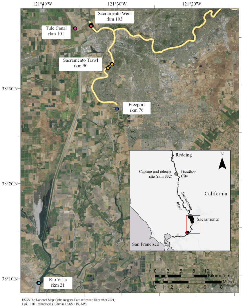
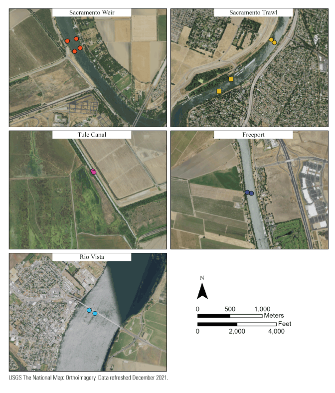
Summarized acoustic telemetry detection sites (lightly shaded circles) between river kilometers (rkms) 103 and 21, and capture and release site (inset), in the Sacramento River, California. Separate colors are used to represent telemetry groupings by site. The capture and release site at rkm 332 is indicated in reference to the American River Watershed Common Features Project study area (box). The heavy line indicates the American River Watershed Common Features Project. USGS, U.S. Geological Survey; EPA, U.S. Environmental Protection Agency; NPS, National Park Service.
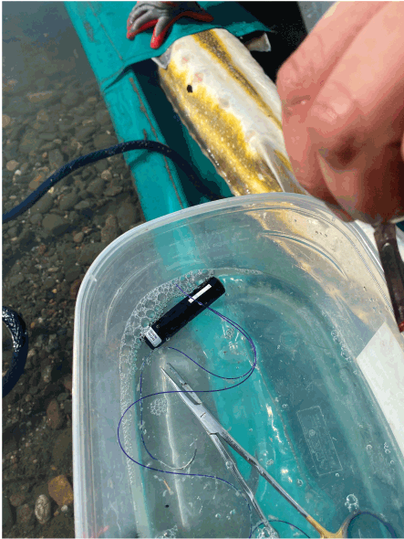
Acoustic tag, Passive Integrated Transponder tag, surgical tools, and adult green sturgeon (Acipenser medirostris) ready for tagging. Photograph by Amy Hansen, U.S. Geological Survey, October 28, 2022.
Acoustic Detection Sites
A combination of acoustic receivers operating at 69 kilohertz (kHz) tracked tagged fish at five locations from December 4, 2020, to January 31, 2023: (1) the Sacramento Weir; (2) Tule Canal; (3) Sacramento River at rkm 90 (hereinafter Sacramento Trawl); (4) near Freeport, California; and (5) Highway 12 Helen Madere Memorial Rio Vista Bridge in Rio Vista, California (hereinafter Rio Vista) (fig. 1, table 1). USGS personnel deployed and maintained receivers at all the sites except for Rio Vista, which was deployed and maintained by California Department of Fish and Wildlife. Personnel from both organizations deployed a total of 8–14 acoustic receivers at the five locations in the lower Sacramento River and Tule Canal (fig. 1). The deployment description that follows is of USGS sites.
Table 1.
Dates of acoustic receiver deployment changes in the American River Watershed Common Features Project study area, California.[Except for the right-most column, each of the columns with dates as column headers indicates the number of receivers deployed on a given date through the date in the next column to the right. rkm, river kilometer; mm-dd-yy, month, day, year; na, site not deployed in this time period]
USGS personnel downloaded and checked USGS receivers for operation about every 90 to 120 days. Three 69-kHz acoustic receiver models (VR2AR, VR2Tx, VR2W) detected fish depending on equipment availability. We received data for California Department of Fish and Wildlife receivers on September 22, 2023.
Taut-wire moorings or weighted-frame mounts secured receivers in place. In a taut-wire mooring, an acoustic receiver was attached to an anchor weight using stainless-steel cable (fig. 3). Personnel deployed the weight and receiver from a research vessel in the desired monitoring location. A float, attached to the acoustic receiver, kept the hydrophone elevated off the streambed by about 1 meter (m). In a weighted-frame mount, acoustic receivers were attached to a weighted aluminum frame (fig. 4). Personnel deployed the receiver and frame from a research vessel in the desired monitoring location using a removable deployment device. Using this method, the hydrophone remains elevated off the streambed by about 0.5 m. In some cases, multiple acoustic receivers are attached to a single frame to allow for detection of various acoustic-tagged species.
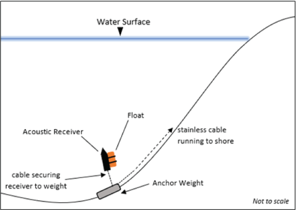
Schematic showing taut-wire mooring deployment method.
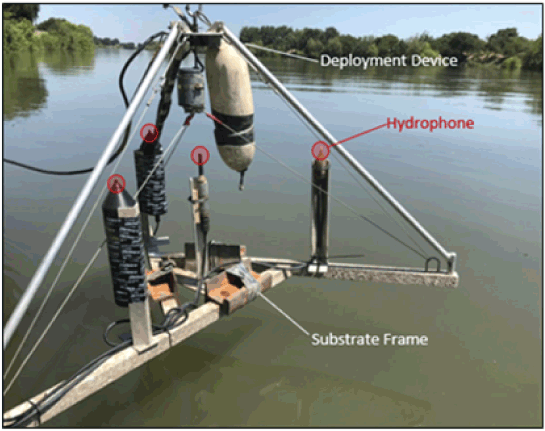
Weighted-frame deployment method. The deployment device is removed following deployment on the streambed. Photograph by Ryan Johnson, U.S. Geological Survey.
Sacramento Weir
USGS personnel deployed 4–6 acoustic receivers in the Sacramento River near the Sacramento Weir entrance (table 1). On December 4, 2020, they deployed four VR2Tx receivers in a clustered array in the Sacramento River upstream from the Sacramento Weir entrance at rkm 103 (figs. 1, 5). On February 9, 2022, it was discovered that levee construction disturbed one receiver on the right bank of the river when facing downstream, but no data were missing. Personnel deployed two additional VR2AR receivers with the existing right bank receivers on March 1, 2022. All configurations of receiver deployment monitored the full width of the river.
Locations of acoustic telemetry receivers deployed in the Sacramento River and Tule Canal, California, December 4, 2020–January 31, 2023. Squares represent the original deployment and circles represent the current deployment. USGS, U.S. Geological Survey.
Tule Canal
USGS personnel deployed two receivers on October 19, 2021, in the Tule Canal, upstream from the Sacramento Bypass, which connects to the Sacramento River at rkm 101 (table 1; figs. 1, 5). The two VR2AR receivers were deployed within 28 m of each other.
Sacramento Trawl
USGS personnel deployed two receivers on December 4, 2020, at the Sacramento Trawl site (table 1, figs. 1, 5). A VR2Tx and VR2W receiver were each deployed at rkm 90. On November 10, 2022, these receivers were moved 1.2 km upstream.
Freeport
USGS personnel deployed two VR2AR receivers at the Freeport site in the Sacramento River at rkm 76 on November 10, 2022 (table 1; figs. 1, 5). Receivers deployed on both shorelines monitored the full width of the river.
Rio Vista
To provide information about fish traveling through the American River Watershed Common Features Project study area (hereinafter referred to as the “study area”) and before entering salt water, the California Department of Fish and Wildlife deployed receivers at the Rio Vista site in the Sacramento River at rkm 21 prior to the beginning of the study (table 1; figs. 1, 5).
Data Analysis
To associate fish movements with streamflow, we downloaded mean daily Sacramento River streamflow at Freeport from https://waterdata.usgs.gov/ on October 26, 2023, station 11447650 (U.S. Geological Survey, 2023), for water years (WYs) 2021–22. We plotted data by water year and labeled each year based on the calendar year at the end of the water year. We accessed water-year hydrological classifications (such as dry, critically dry, etc.) which were assigned in May following the end of the water year at https://cdec.water.ca.gov/reportapp/javareports?name=WSIHIST (California Department of Water Resources, 2023). .
We summarized telemetry data to examine seasonal timing of arrival, time spent between detection sites and throughout the study area, duration of time fish spent at each site (residency time), and diel patterns in movement past receiver locations. To check for false detections, we examined data for each fish by plotting waterfall plots in R (R Core Team 2023; detections by river kilometer, date, and time). Detections out of geographic order (that is, skipping detection sites and upstream movement during the downstream migration) indicated potentially false detections. All data were examined, and we identified no false positives. To describe the time fish spent moving between sites, we calculated the elapsed time from (1) release to first detection at the most upstream site (travel time from release), (2) last detection at a previous site and first detection at the next site, and (3) last detection at the most upstream site and first detection at the most downstream site. We summarized these elapsed times using the Kaplan-Meier time-to-event function. Significance was evaluated relative to the P<0.05 level. We plotted travel time from release to the study area by grouping the fish by calendar year of release to express extended travel times. We plotted all other travel times by grouping the fish by water year of movement. We calculated residence time as the elapsed time between the first and last detections at a site. If a fish returned to a site after being detected at another site, we calculated a second elapsed residence time using the first and last detections at a site for the second trip. We examined diel patterns by plotting the hour of first arrival at each site using rose plots.
Results and Discussion
Fish Tagging
The USACE tagged a total of 55 sturgeon during September 2021–22, October 2020–22, and November 2020 (table 2). Mean total length and girth were similar between years and ranged from 1.5 to 2.2 m in total length and from 0.5 to 0.7 m in girth (table 3).
Table 2.
Number of acoustic tagged green sturgeon (Acipenser medirostris) released by month near river kilometer 332 in the Sacramento River, California, 2020–22.[Fish tagged in September were grouped into the following water year beginning in October]
Sacramento River Flow
The frequency, duration, and magnitude of Sacramento River flow deviating from base flow varied among water years (fig. 6). In all water years, base flows were about 10,000 cubic feet per second (ft3/s). WY 2021 was a critically dry year, in which flows remained near base levels except for during a few brief periods in February and March when small increases in flow (<8,000 ft3/s) occurred. WY 2022 also was a critically dry year, with flows near base levels most of the year interrupted by a few flow peaks. There were three peaks in flow in WY 2022 occurring on October 27, 2021 (36,400 ft3/s), December 16, 2021 (28,800 ft3/s) and December 27, 2021 (35,000 ft3/s). These peaks were followed by base flow from February through mid-December 2022. The greatest peak flows during our study period occurred in WY 2023. The first flow peak in WY 2023 occurred on December 13, 2022 (20,000 ft3/s) and was more than double the highest flow in WY 2022 and more than four times the greatest flow in WY 2021. This increase began in late December 2022 and peaked at 80,200 ft3/s on January 10, 2023, decreased to 24,500 ft3/s on January 31, 2023, at the end of this reporting period.
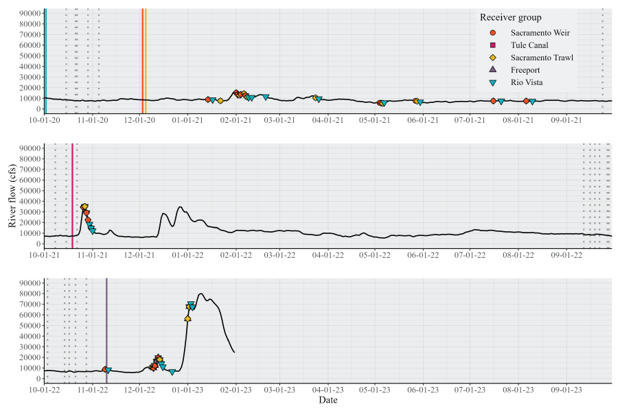
First arrival date (symbols) of individually acoustic-tagged green sturgeon (Acipenser medirostris) at each site and corresponding mean daily flow on the Sacramento River (solid black line), California, by water year (October 1–September 30), October 1, 2020, through January 31, 2023. Solid vertical lines indicate receiver deployment dates and dotted vertical lines indicate fish release dates. cfs, cubic feet per second.
Detections in the Study Area
Receivers detected all tagged sDPS green sturgeon in our study area. Nearly all the 55 tagged sturgeon moved downriver within the study area in the same water year they were tagged. Three of the fish tagged in WY 2021 remained upstream from the study area for more than 1 year and moved downstream in October 2021. All fish were detected at the Sacramento Weir site and 54 of the 55 fish were detected at the Sacramento Trawl site (fig. 6, table 4). No fish were detected at the Tule Canal site (table 4). The Freeport site was installed after the last fish release, but it detected 16 of the 20 downstream migrants tagged in fall 2022 (table 4). Fifty-one of 55 tagged fish were detected at the Rio Vista site.
Table 4.
Number (and percentage) of acoustic-tagged green sturgeon (Acipenser medirostris) detected at sites in the Sacramento–San Joaquin River Delta, California, water years 2020–23.[Freeport was installed after all fish were released in fall 2022. n, number of tagged fish detected at site. Numbers in parentheses are percentage of tagged fish detected at site.]
Fish movements through the study area in WYs 2022 and 2023 were concentrated in November and December and seemed to be associated with large increases in river flow, but in WY 2021, movements were spread over several months (fig. 6). In WY 2021, downstream movements were observed in January, February, March, May, July, and August during both modest increases and decreases in flow. All fish tagged in fall 2021 (WY 2022) quickly moved downstream through the study area on the descending flow during the late October flow peak. In WY 2023, fish moved downstream through the study area in two short time periods. Most (70 percent of released) fish arrived at detection sites in mid-December during the moderate flow increase, but some fish (25 percent) were detected in late December during the high flows and in mid-November.
During the high flow in late December 2022–January 2023, there were fewer tag detections per fish than in the previous pulses of fish movements. This pattern is likely due to fish moving quickly past the detection sites, but it could also indicate a reduced ability to detect tags during noisy and turbid river conditions. We did not detect 100 percent of fish at the Freeport site in WY 2023; however, all fish were detected downstream at Rio Vista. Several fish only had one detection at a site during this highest flow peak, lending evidence that some fish passed through the area without being detected.
Travel Time from Release
Travel time from the release location to the Sacramento Weir was significantly different by each release year (P < 0.0001). Median travel time for fish released in 2020 was 110 days and extended to 377 days and was longer than the other years (fig. 7). Three fish were detected in the study area more than 1 year after release. All released fish in 2021 traveled to the Sacramento Weir from 4.7 to 32.2 days (median, 18.3 days), which resulted in the shortest travel time among the 3 years. Median travel time for fish released in 2022 was 76.9 days and ranged from 11.4 to 107.0 days.
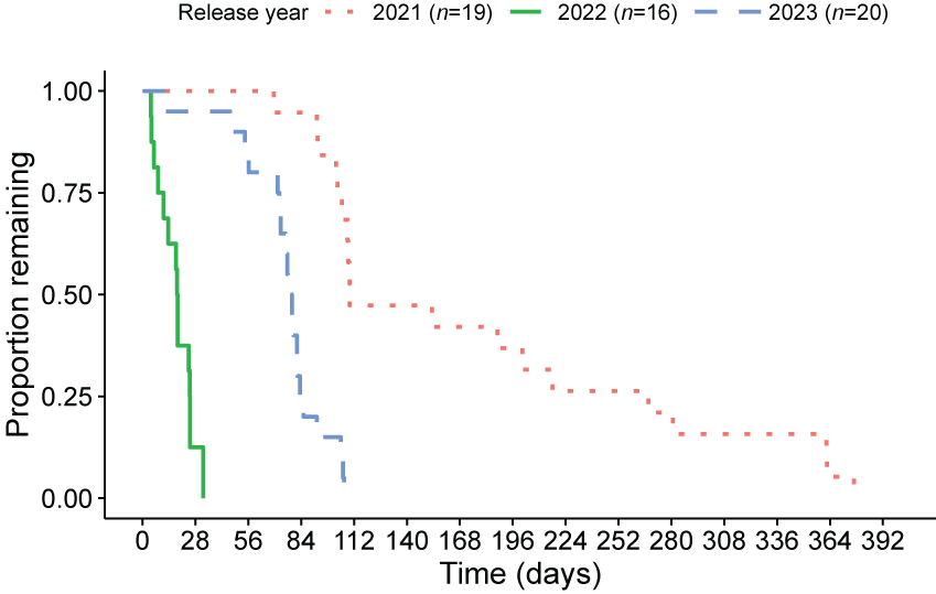
Travel time of acoustic tagged adult green sturgeon (Acipenser medirostris) from release in the Sacramento River at river kilometer (rkm) 332 to the Sacramento Weir site at rkm 103 in the Sacramento–San Joaquin River Delta, California, by calendar year of release, 2020–22. n, number of tagged fish detected.
Travel Between Sites
Once tagged fish arrived in the study area, they moved quickly downstream in all three water years. Median travel time between pairs of sites and among water years ranged from 185 to 1,779 minutes (table 5, figs. 8–11). During the low streamflows of WY 2021, maximum travel times between Sacramento Weir and Sacramento Trawl were 2–3 times longer than the maximums in the other two water years (fig. 8). Median travel times were shortest in WY 2022 (185 minutes), intermediate in WY 2023 (215 minutes), and longest in WY 2021 (321 minutes), and were significantly different between the three water years (P< 0.0001; fig. 8). In WY 2023, 0.73 fish traveled from Sacramento Trawl to Freeport from 284 to 369 minutes (fig. 9) and more than 0.87 fish traveled from Freeport to Rio Vista from 1,064 to 2,691 minutes (fig. 10). In the entire 82-km study reach from Sacramento Weir to Rio Vista (fig. 11), tagged sturgeon followed a pattern similar to that of the individual reaches. Median annual fish travel times ranged from 1.1 to 2.5 days and differed significantly among water years (P=0.00023; fig. 11).
Table 5.
Median travel time of acoustic tagged adult green sturgeon (Acipenser medirostris) between sites in the Sacramento–San Joaquin River Delta, California, water years 2021–23.[na, not applicable; WY, water year]
![Travel time between the Sacramento Weir (river kilometer [rkm 103]) and the Sacramento
Trawl (rkm 90) in the Sacramento–San Joaquin River Delta for most fish was less than
600 minutes except in 2021, water years 2021–23.](https://pubs.usgs.gov/of/2024/1025/images/ofr20241025_fig08.png)
Travel time of acoustic tagged adult green sturgeon (Acipenser medirostris) between the Sacramento Weir (river kilometer [rkm 103]) and the Sacramento Trawl (rkm 90) sites in the Sacramento–San Joaquin River Delta, California, water years 2021–23. n, number of tagged fish detected.
![Travel time between the Sacramento Trawl (river kilometer [rkm] 90) and Freeport (rkm
76) sites in the Sacramento–San Joaquin River Delta, California, was from 240 to 360
minutes in water year 2023.](https://pubs.usgs.gov/of/2024/1025/images/ofr20241025_fig09.png)
Travel time of acoustic tagged adult green sturgeon (Acipenser medirostris) between the Sacramento Trawl (river kilometer [rkm] 90) and Freeport (rkm 76) sites in the Sacramento–San Joaquin River Delta, California, water year 2023. n, number of tagged fish detected.
![Travel time between the Freeport (river kilometer [rkm] 76) and Rio Vista (rkm 21)
sites in the Sacramento–San Joaquin River Delta, California, was from 1,064 to 2,691
minutes for most fish in water year 2023.](https://pubs.usgs.gov/of/2024/1025/images/ofr20241025_fig10.png)
Travel time of acoustic tagged adult green sturgeon (Acipenser medirostris) between the Freeport (river kilometer [rkm] 76) and Rio Vista (rkm 21) sites in the Sacramento–San Joaquin River Delta, California, water year 2023. n, number of tagged fish detected.
![Travel time between the Sacramento Weir (river kilometer [rkm] 103) and Rio Vista
(rkm 21) sites in the Sacramento–San Joaquin River Delta, California, was from 24
to 120 hours for most fish in water years 2021–23 except one fish in water year 2023.](https://pubs.usgs.gov/of/2024/1025/images/ofr20241025_fig11.png)
Travel time of acoustic tagged adult green sturgeon (Acipenser medirostris) between the Sacramento Weir (river kilometer [rkm] 103) and Rio Vista (rkm 21) sites in the Sacramento–San Joaquin River Delta, California, water years 2021–23. n, number of tagged fish detected.
All fish movements were downstream except for one fish that made multiple trips between the Sacramento Weir and Sacramento Trawl sites in 2021. This fish was detected at Sacramento Trawl on February 3, had a gap in detections until February 9, and then moved upstream and was detected at the Sacramento Weir site on February 10. After a 7-day gap of detections, this fish was detected again at the Sacramento Weir site on February 17, at the Sacramento Trawl site on February 18, and at the Rio Vista site on February 19 and 20. The Freeport site was not deployed during this period.
Residence Time at Sites
With few exceptions, the elapsed time between the first and last detections at each site was less than 1 hour. All median residence times at Sacramento Weir, Sacramento Trawl, and Freeport ranged from 4 to 26 minutes among water years (fig. 12). Median residence time at Sacramento Weir (14 minutes; range, 4–567 minutes) and Sacramento Trawl sites (26 minutes; range, 16–417 minutes) were 1.5–3.5 times longer in WY 2021 than in the other two water years (fig. 13). Residence time at Freeport ranged from 0 minute (where there were single detections during the high flow) to 53 minutes in WY 2023 when the site was deployed. Long residence times included periods where the fish went undetected for a period at any sites, followed by another detection at the last site they visited. We presumed that this pattern in the data indicated temporary absence from the site, but summarized these as single events in our residency time analysis. Residence time at Rio Vista was calculated in days (fig. 13) and ranged from 0 to 42 days, but most fish were detected less than 18 hours.
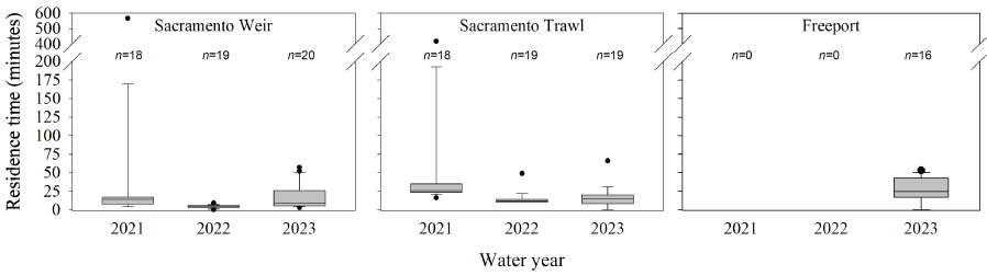
Boxplots showing residence times of acoustic tagged adult green sturgeon (Acipenser medirostris) at each site in the Sacramento–San Joaquin River Delta, California, water years 2021–23. Horizontal line in each box represents the median, box hinges bounding the shaded gray area represent the 25th and 75th percentiles, whiskers represent the minimum and maximum values, and dots represent outliers. n, number of tagged fish detected.
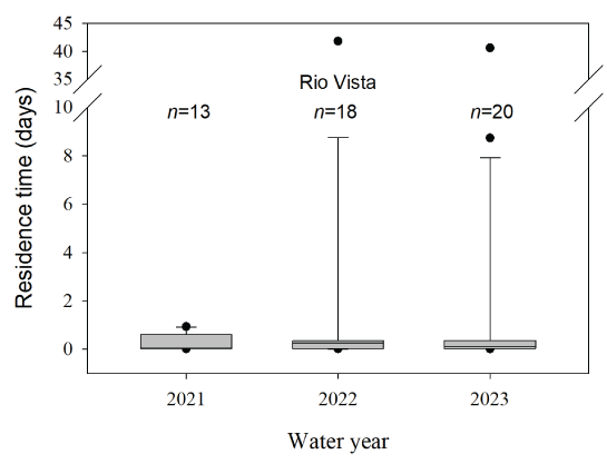
Boxplots showing residence time of acoustic tagged adult green sturgeon (Acipenser medirostris) at Rio Vista (river kilometer 21) in the Sacramento–San Joaquin River Delta, California, water years 2021–23. Horizontal line in each box represents the median, box hinges bounding the shaded gray area represent the 25th and 75th percentiles, whiskers represent the minimum and maximum values, and dots represent outliers. n, number of tagged fish detected.
Based on the short residence times at the Sacramento Weir, Sacramento Trawl, and Freeport sites and the short travel times between them, sDPS green sturgeon are migrating through this corridor and not residualizing (USACE, 2021). In most years, saltwater intrusion extends into the Sacramento River to Rio Vista and tidally influenced reversing flows extend to Freeport (USGS, 2016). We observed longer residence times in this saltwater area, which indicate that fish may be foraging and feeding.
The rapid outmigration of individual sDPS green sturgeon through our study area prior to the ARCF construction was expected based on previous reports on sturgeon migration. Miller and others (2020) documented that fish spent 3 ±8.5 days in the Sacramento–San Joaquin River Delta post-spawn. Erickson and Webb (2007) and Erickson and others (2002) also reported that fall migrating adult green sturgeon quickly out-migrated from the Rouge River, Oregon, to the ocean during water temperatures around 10 °C and peaks in flow. Benson and others (2007) found that green sturgeon quickly migrated in fall after spawning in the Klamath River with increases in flow at least twice the summer base flows. Heublein and others (2009) reported similar timing of post-spawning migration in the Sacramento River in fall with the first flow event and before September without any known environmental cue.
Diel Arrival
There were no diel patterns in arrival timing at any of the sites during the downstream migration. Fish arrived at nearly all hours of the day and night regardless of year and site (fig. 14). Fish tended to arrive at the Sacramento Weir site at around 1600 and 0300 hours (16 and 3, respectively, on fig. 14 clocks), whereas they arrived at the Sacramento Trawl site at around 1800–2100 and 0700–0800 hours (18–21 and 7–8, respectively, on fig. 14 clocks), which corresponds to fish leaving the Sacramento Weir site and the median travel time to the Sacramento Trawl site. Similarly, Kelly and others (2007) found no relation with crepuscular, nocturnal, or diurnal peaks in activity downstream in San Pablo Bay.
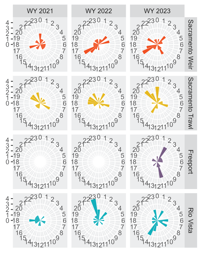
Rose diagrams showing arrival hour of acoustic-tagged adult green sturgeon (Acipenser medirostris) during the downstream migration at detection sites in the Sacramento–San Joaquin River Delta, California, water years 2021–23. Distance of the bars from the origin indicates frequency of occurrence. Freeport site was deployed on November 10, 2022. WY, water year.
Conclusions
All fish tagged in our study were detected while outmigrating in fall, making them late migrants (Colborne and others, 2022), at least within the sampling year. Colborne and others (2022) showed that 68 percent of adults analyzed used the late outmigration strategy, with the remainder using an early (spring) outmigration strategy. Colborne and others (2022) performed a meta-analysis of repeat spawners to test early compared to late outmigration timing across individuals with observed repeated spawning bouts. In total, 23 of 62 individuals that repeat spawned showed a switch in outmigration strategy, where a second spawning bout resulted in an opposite outmigration strategy than had been previously observed. This switch in behavior was attributed to environmental stimuli and, more specifically, to differences in spring river discharge. Therefore, in future monitoring years the tagging of fall outmigrants likely will result in observations of early outmigrant trajectories. Inclusion of upstream migrating fish tagged by California Department of Fish and Wildlife after rescue at the Tisdale Weir, Freemont Weir, and Yolo Bypass may diversify the life histories available for study. Additionally, the U.S. Army Corps of Engineers will continue to tag and monitor adult southern Distinct Population Segment (sDPS) green sturgeon in the Sacramento–San Joaquin River Delta while civil works impacts under the American River Watershed Common Features (ARCF) program are occurring. Because tagged adult sDPS green sturgeon are spending minimal time in the ARCF area during the construction window of July–October, the civil works projects will potentially have limited impacts on fish migrating to the spawning grounds during future construction periods.
References Cited
Adams, P.B., Grimes, C., Hightower, J.E., Lindley, S.T., Moser, M.L., and Parsley, M.P., 2007, Population status of North American green sturgeon, Acipenser medirostris: Environmental Biology of Fishes, v. 79, p. 339–356, accessed September 15, 2021, at https://link.springer.com/content/pdf/10.1007/s10641-006-9062-z.pdf.
Beccio, M., 2018, 2018 Yuba River sturgeon spawning study: Memorandum to Colin Purdy of California Department of Fish and Wildlife, 10 p., accessed November 29, 2023, at https://www.calfish.org/ProgramsData/ConservationandManagement/CentralValleyMonitoring/YubaRiverSturgeonSpawning.aspx.
Beccio, M., 2022, 2021 Yuba River sturgeon spawning study: Memorandum to Nick Bauer of California Department of Fish and Wildlife, 8 p., accessed November 9, 2022 at https://nrm.dfg.ca.gov/FileHandler.ashx?DocumentID=200702&inline.
Benson, R.L., Turo, S., and McCovey, B.W., Jr., 2007, Migration and movement patterns of green sturgeon (Acipenser medirostris) in the Klamath and Trinity rivers, California, USA: Environmental Biology of Fishes, v. 79, p. 269–279, accessed September 17, 2021, at https://doi.org/10.1007/s10641-006-9023-6.
California Department of Water Resources, 2023, Department of Water Resources California cooperative snow surveys: California Department of Water Resources web interface, accessed October 26, 2023, at https://cdec.water.ca.gov/reportapp/javareports?name=WSIHIST.
Colborne, S.F., Sheppard, L.W., O’Donnell, D.R., Reuman, D.C., Walter, J.A., Singer, G.P., Kelly, J.T., Thomas, M.J., and Rypel, A.L., 2022, Intraspecific variation in migration timing of green sturgeon in the Sacramento River system: Ecosphere, v. 13, no. 6, p. e4139, accessed June 22, 2023, at https://doi.org/10.1002/ecs2.4139.
Erickson, D.L., North, J.A., Hightower, J.E., Weber, J., and Lauck, L., 2002, Movement and habitat use of green sturgeon Acipenser medirostris in the Rogue River, Oregon, USA: Journal of Applied Ichthyology, v. 18, p. 565–569, accessed May 31, 2023, at https://fnw.ratcatinc.com/121521ar/AR013737.pdf.
Erickson, D.L., and Webb, M.A.H., 2007, Spawning periodicity, spawning migration, and size at maturity of green sturgeon, Acipenser medirostris, in the Rouge River, Oregon: Environmental Biology of Fishes, v. 79, p. 255–268, accessed November 14, 2023, at https://link.springer.com/content/pdf/10.1007/s10641-006-9072-x.pdf.
Heublein, J.C., Kelly, J.T., Crocker, C.E., Klimley, A.P., and Lindley, S.T., 2009, Migration of green sturgeon (Acipenser medirostris) in the Sacramento River: Environmental Biology of Fishes, v. 84, p. 245–258, accessed May 26, 2022, at https://link.springer.com/article/10.1007/s10641-008-9432-9#article-info.
Kelly, J.T., Klimley, A.P., and Crocker, C.E., 2007, Movements of green sturgeon, Acipenser medirostris, in the San Francisco Bay estuary, California: Environmental Biology of Fishes, v. 79, p. 281–295, accessed September 17, 2021, at https://link.springer.com/content/pdf/10.1007/s10641-006-0036-y.pdf.
Kynard, B., Parker, E., and Parker, T., 2005, Behavior of early life intervals of Klamath River green sturgeon, Acipenser medirostris, with a note on body color: Environmental Biology of Fishes, v. 72, p. 85–97, accessed December 28, 2021, at https://link.springer.com/content/pdf/10.1007/s10641-004-6584-0.pdf.
Miller, E.A., Singer, G.P., Peterson, M.L., Chapman, E.D., Johnston, M.E., Thomas, M.J., Battleson, R.D., Gingras, M., and Klimley, A.P., 2020, Spatio-temporal distribution of green sturgeon (Acipenser medirostris) and white sturgeon (A. transmontanus) in the San Francisco Estuary and Sacramento River, California: Environmental Biology of Fishes, v. 103, p. 577–603, accessed January 7, 2022, at https://doi.org/10.1007/s10641-020-00972-x.
Moser, M.L., Israel, J.A., Neuman, M., Lindley, S.T., Erickson, D.L., McCovey, B.W., Jr., and Klimley, A.P., 2016, Biology and life history of green sturgeon (Acipenser medirostris Ayers, 1854)—State of the science: Journal of Applied Ichthyology, v. 32, p. 67–86, accessed September 17, 2021, https://onlinelibrary.wiley.com/doi/pdf/10.1111/jai.13238.
National Marine Fisheries Service [NMFS], 2015, Endangered Species Act Section 7(a)(2) Biological Opinion, and Magnuson-Stevens Fishery Conservation and Management Act Essential Fish Habitat Response, for the American River Common Features General Reevaluation Report (Common Features GRR): NMFS Number WCR-2014-1377, 235 p., [Also available at https://repository.library.noaa.gov/view/noaa/48567.]
Poytress, W.R., Gruber, J.J., and Eenennaam, J.V., 2012, 2011 Upper Sacramento River green sturgeon spawning habitat and larval migration surveys—Final annual report: Prepared for United States Bureau of Reclamation, 39 p. [Also available at https://www.noaa.gov/sites/default/files/legacy/document/2020/Oct/07354626275.pdf.]
Poytress, W.R., Gruber, J.J., Van Eenennaam, J.P., and Gard, M., 2015, Spatial and Temporal Distribution of Spawning Events and Habitat Characteristics of Sacramento River Green Sturgeon: Transactions of the American Fisheries Society, v. 144, no. 6, p. 1129–1142, accessed September 17, 2021, at https://doi.org/10.1080/00028487.2015.1069213.
R Core Team, 2023, R—A language and environment for statistical: Vienna, Austria, R Foundation for Statistical Computing, accessed September 1, 2022, at https://www.R-project.org/.
Seesholtz, A.M., Manuel, M.J., and Van Eenennaam, J.P., 2015, First documented spawning and associated habitat conditions for green sturgeon in the Feather River, California: Environmental Biology of Fishes, v. 98, p. 905–912, accessed November 2, 2022, at https://doi.org/10.1007/s10641-014-0325-9.
Thomas, M.J., Peterson, M.L., Chapman, E.D., Hearn, A.R., Singer, G.P., Battleson, R.D., and Klimley, A.P., 2014, 2014, Behavior, movements, and habitat use of adult green sturgeon, Acipenser medirostris, in the upper Sacramento River: Environmental Biology of Fishes, v. 97, p. 133–146, accessed February 7, 2023, at https://doi.org/10.1007/s10641-013-0132-8.
U.S. Army Corps of Engineers [USACE], 2021, Green sturgeon habitat mitigation and monitoring plan: U.S. Army Corps of Engineers, Sacramento District, Sacramento, California, 30 p. plus appendixes, accessed January 21, 2021, at https://www.spk.usace.army.mil/Media/USACE-Project-Public-Notices/.
U.S. Geological Survey [USGS], 2016, Innovation in monitoring—The U.S. Geological Survey Sacramento–San Joaquin River Delta, California, flow-station network: U.S. Geological Survey Fact Sheet 2015–3061, 6 p., accessed December 29, 2021, at https://doi.org/10.3133/fs20153061.
U.S. Geological Survey, 2023, USGS National Water Information System: U.S. Geological Survey web interface, accessed October 26, 2023, at https://doi.org/10.5066/F7P55KJN.
Van Eenennaam, J.P., Linares-Casenave, J., Deng, X., and Doroshov, S.I., 2005, Effect of incubation temperature on green sturgeon embryos, Acipenser medirostris: Environmental Biology of Fishes, v. 72, p. 145–154, accessed May 31, 2023, at https://link.springer.com/content/pdf/10.1007/s10641-004-8758-1.pdf.
Conversion Factors
Disclaimers
Any use of trade, firm, or product names is for descriptive purposes only and does not imply endorsement by the U.S. Government.
Although this information product, for the most part, is in the public domain, it also may contain copyrighted materials as noted in the text. Permission to reproduce copyrighted items must be secured from the copyright owner.
Suggested Citation
Hansen, A.C., Burdick, S.M., Johnson, R.P., Chase, R.D., and Thomas, M.J., 2024, Adult green sturgeon (Acipenser medirostris) movements in the Sacramento–San Joaquin River Delta, California, December 2020–January 2023: U.S. Geological Survey Open-File Report 2024–1025, 17 p., https://doi.org/10.3133/ofr20241025.
ISSN: 2331-1258 (online)
Study Area
| Publication type | Report |
|---|---|
| Publication Subtype | USGS Numbered Series |
| Title | Adult green sturgeon (Acipenser medirostris) movements in the Sacramento–San Joaquin River Delta, California, December 2020–January 2023 |
| Series title | Open-File Report |
| Series number | 2024-1025 |
| DOI | 10.3133/ofr20241025 |
| Publication Date | April 30, 2024 |
| Year Published | 2024 |
| Language | English |
| Publisher | U.S. Geological Survey |
| Publisher location | Reston, VA |
| Contributing office(s) | Western Fisheries Research Center |
| Description | vii, 17 p. |
| Country | United States |
| State | California |
| Other Geospatial | Sacramento–San Joaquin River Delta |
| Online Only (Y/N) | Y |