

Geospatial PDF Map of the Compilation of GIS Data for the Mineral Industries and Related Infrastructure of Africa
Links
- Document: Report (12.2 MB pdf) , HTML , XML
- Data Release: USGS data release - Compilation of geospatial data (GIS) for the mineral industries and related infrastructure of Africa
- Download citation as: RIS | Dublin Core
Introduction
In 2021, the U.S. Geological Survey's (USGS) National Minerals Information Center (NMIC) completed the project titled “Compilation of geospatial data for the mineral industries and related infrastructure of Africa.” This project aimed to leverage the expertise and capabilities of the NMIC to collect, synthesize, and interpret geospatial data to inform on the extractive resources of the African region and expand the NMIC's understanding on the impact of mineral industry of African nations in the global economy. The African region, which comprises the independent nations that make up the African continent and its associated islands and dependencies, consists of a total of 58 mineral producing countries. The primary objective of this effort was to create a fully attributed Geographic Information System (GIS) portraying existing mining infrastructure, resources, and development capacity across Africa along with the related infrastructure capable of supporting current (for the reference year 2018) and future extractive industry operations in the region. The compiled GIS geodatabase with supporting documentation including comprehensive metadata was published as a USGS data release titled “Compilation of Geospatial Data (GIS) for the Mineral Industries and Related Infrastructure of Africa” (Padilla and others, 2021).
This georeferenced portable document format (GeoPDF) map sheet presents a new geographic information product containing a partial representation of the GIS data published by Padilla and others (2021). This GeoPDF map provides a visual comparison of the distribution of mineral industry and related infrastructure GIS data, which contributes to a deeper understanding of the intersections and complexities of the extractive industries within Africa.
Overview of Geospatial PDF Map Layout (Layer Navigation and Visibility)
The GeoPDF map sheet created for this project contains the feature datasets and their feature classes organized as map layers. Within a PDF reader, such as Adobe Acrobat Reader, these map layers are accessed through a “Layers” navigation pane in the side panel menu when the GeoPDF file is open. Figure 1 illustrates the navigation pane and a list of feature dataset folders that contain the feature classes, or individual map layers, within the GeoPDF.
If all of the map layers are turned on simultaneously, the map will be illegible due to the number of overlapping map layers and labels present in the GeoPDF. However, a user may selectively turn on or off different map layers and their labels in the layers navigation pane to analyze the spatial relationships between the available map layers. Base cartographic elements that are visible upon opening the GeoPDF map, such as vector polyline data for rivers and vector polygon data for countries for example, can be turned off for clearer visual interpretation of map layers. Additionally, annotation layers for labels, which directly precede their corresponding map layer in the layers navigation pane, can also be turned on and off separately for better visual clarity. A user is able to generate different maps by controlling the visibility of map layers and their labels, which can then be printed as individual maps. For example, a user could overlay oil- and gas-field center points with the USGS petroleum provinces to determine which cluster of oil and gas fields is located within a specific petroleum province; the user will then have the ability to print out that specific representation.
To aid in the visual interpretation of the Mineral Facilities feature class, which contains a large number of overlapping symbols and labels, it was divided into five separate selectable map layers for this GeoPDF based on the categories of facility type: Brine, Mines and Quarries, Mineral Processing Facilities, Oil and Gas Fields, and Oil and Gas Refineries. This allows for a better understanding of the geographic distribution of the various types of facilities. These map layers are located within the “Mineral Facilities” feature dataset folder in the layers navigation pane. No other feature classes were modified from the original geodatabase from Padilla and others (2021).
This GeoPDF also includes a subset of the attribute data for 12 of the feature classes that are contained within the “Africa_GIS.gdb” geodatabase file (Padilla and others, 2021). The attribute data are presented using the schema from Padilla and others (2021), and table 1 can be used to interpret the attribute field names with their associated attribute field aliases. In this table, attribute data for the Mineral Facilities feature dataset are provided since attribute names and aliases are identical for the five mineral facility type map layers. The attribute data contained within the GeoPDF map can be accessed using the “Identify” tool in the TerraGo Toolbar, which can be downloaded and installed at no cost from https://terragotech.com/products/geopdf/toolbar/ (TerraGo Technologies, Inc., 2024a). Detailed instructions for navigating the layers of the GeoPDF map as well as accessing the attribute data can be found in Baker and others (2017) and TerraGo Technologies, Inc. (2024b).
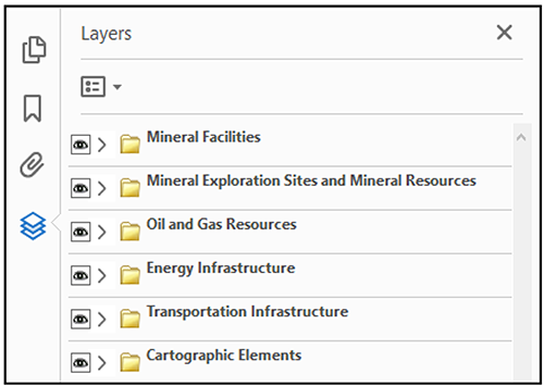
Screenshot of the “Layers” navigation pane open and the list of feature dataset folders within the GeoPDF (visibility of all feature dataset folders is turned on).
Table 1.
List of attribute field names and their associated field aliases from the “Africa_GIS.gdb” geodatabase (Padilla and others, 2021) provided to aid in the interpretation of the project schema when viewing attribute data using the “Identify” tool in the TerraGo Toolbar (geodatabase feature class names are provided in parentheses).References Cited
[For a full list of references cited, see the associated geodatabase by Padilla and others (2021)]
Baker, M.S., Buteyn, S.D., Freeman, P.A., Trippi, M.H., and Trimmer, L.M., III, 2017, Compilation of geospatial data for the mineral industries and related infrastructure of Latin America and the Caribbean: U.S. Geological Survey Open-File Report 2017–1079, 87 p., 1 geodatabase and 1 geospatial PDF map, https://doi.org/10.3133/ofr20171079.
Padilla, A.J., Otarod, D., Deloach-Overton, S.W., Kemna, R.F., Freeman, P.A., Wolfe, E.R., Bird, L.R., Gulley, A.L., Trippi, M.H., Dicken, C.L., Hammarstrom, J.M., and Brioche, A.S., 2021, Compilation of geospatial data (GIS) for the mineral industries and related infrastructure of Africa: U.S. Geological Survey data release, https://doi.org/10.5066/P97EQWXP.
TerraGo Technologies, Inc., 2024a, GeoPDF toolbar: TerraGo Technologies, Inc., accessed April 19, 2024, at https://terragotech.com/products/geopdf/toolbar/.
TerraGo Technologies, Inc., 2024b, GeoPDF toolbar: TerraGo Technologies, Inc., accessed April 19, 2024, https://support.terragotech.com/hc/en-us/categories/360004388494-GeoPDF-Toolbar.
Disclaimers
Any use of trade, firm, or product names is for descriptive purposes only and does not imply endorsement by the U.S. Government.
Although this information product, for the most part, is in the public domain, it also may contain copyrighted materials as noted in the text. Permission to reproduce copyrighted items must be secured from the copyright owner.
Suggested Citation
Neustaedter, E.R., Kemna, R.F., Padilla, A.J., and Otarod, D., 2024, Geospatial PDF map of the compilation of GIS data for the mineral industries and related infrastructure of Africa: U.S. Geological Survey Open-File Report 2024–1041, 1 geospatial map, scale 1:38,504,000, https://doi.org/10.3133/ofr20241041.
ISSN: 2331-1258 (online)
Study Area
| Publication type | Report |
|---|---|
| Publication Subtype | USGS Numbered Series |
| Title | Geospatial PDF map of the compilation of GIS data for the mineral industries and related infrastructure of Africa |
| Series title | Open-File Report |
| Series number | 2024-1041 |
| DOI | 10.3133/ofr20241041 |
| Publication Date | July 02, 2024 |
| Year Published | 2024 |
| Language | English |
| Publisher | U.S. Geological Survey |
| Publisher location | Reston, VA |
| Contributing office(s) | National Minerals Information Center |
| Description | 1 Map: 18.00 x 12.00 inches; Data Release |
| Other Geospatial | Africa |
| Online Only (Y/N) | Y |
| Additional Online Files (Y/N) | N |