

U.S. Geological Survey Mississippi River Science Forum—Summary of Data and Science Needs and Next Steps
Links
- Document: Report (1.5 MB pdf) , HTML , XML
- Download citation as: RIS | Dublin Core
Abstract
The U.S. Geological Survey hosted a Mississippi River Science Forum with Federal agencies; Tribal, State, and local governments located in States that border the Mississippi River; academia; and other interested stakeholders. The purpose of the forum was to share current (2023) science; identify data gaps and areas of concern; and to prioritize next steps needed to advance the goals of improving water quality, restoring habitat and natural systems, improving navigation, eliminating aquatic invasive species, and building local resilience to natural disasters along the Mississippi River. The forum was a directive for the U.S. Geological Survey in the Consolidated Appropriations Act of 2022 (Public Law 117—103, 136 Stat. 49).
Participants and stakeholders that attended the Mississippi River Science Forum indicated the following.
-
• A Mississippi River Science Committee could bring together the voices of all stakeholders, including Federal agencies; State, local, and Tribal governments; academia; nongovernmental organizations; business and industry; and other interested parties. This committee would also work with (but not replace) Mississippi River Basin (MRB) entities already in place and establish effective communication to identify and address Basin-wide management needs and to develop holistic solutions for those needs.
-
• A Mississippi River science plan could expand on the science and data gaps identified by the Forum. This plan could guide data collection and help resource managers develop and implement restoration initiatives within the Basin, recognizing that addressing these needs will require substantial resources.
-
• The science committee, working with other entities in the basin, should develop data standards for the Mississippi River Basin that allow stakeholders to utilize comparable data to address their needs. These standards would include data findability, accessibility, interoperability, and reusability.
This report highlights data gaps and areas of concern discussed during the forum, and it identifies needs to advance the goals of improving water quality, restoring habitat and natural systems, improving navigation, eliminating aquatic invasive species, and building local resilience to natural disasters with specific emphasis on data collection and measurement, and scientific investigation. The report also summarizes stakeholder input and feedback and outlines next steps identified by forum participants.
Collaboration with Stakeholders
To better understand the gaps, concerns, and priorities across the Mississippi River, the U.S. Geological Survey (USGS) engaged with partners and regional stakeholders through the Mississippi River Science Forum. This engagement included 29 speakers and more than 400 online attendees from a variety of Federal agencies; Tribal, State, and local governments; academia; and other interested stakeholders herein known as the participants. The speakers represented the U.S. Department of the Interior, the USGS, the Prairie Island Indian Community, the U.S. Army Corps of Engineers , the U.S. Environmental Protection Agency (EPA), the Mississippi River Cities and Towns Initiative, the Upper Mississippi River Conservation Committee, the Lower Mississippi River Conservation Committee, The Nature Conservancy, Ducks Unlimited, the Upper Mississippi River Basin Association, Tulane University, the Louisiana Coastal Protection and Restoration Authority , the U.S. Fish and Wildlife Service, the Mississippi Interstate Cooperative Resource Association , Mississippi State University, the Iowa Department of Natural Resources, Big River Coalition, American Waterways Operators, the National Oceanic and Atmospheric Administration , the Federal Emergency Management Agency, the Ohio River Valley Water Sanitation Commission, the U.S. Department of Agriculture Natural Resources Conservation Service, the Mississippi Levee Board, American Rivers, and the University of Oklahoma. In addition to the forum speakers, more than 500 invitations were sent out to relevant stakeholders and stakeholder groups to participate in the Mississippi River Science Forum. More than 400 stakeholders participated in the virtual forum representing 14 Federal agencies, 3 Tribal nations, 20 State and local governments, 15 academic institutions, and 40 nongovernmental organizations. Participants were encouraged to complete a short list of questions detailing their organization’s Mississippi River priorities. The Mississippi River Science Forum focused on the Mississippi River corridor; however, it is hard to talk about the Mississippi River without including the contributions of the tributaries and the entire Mississippi River Basin. The focus now and into the future needs to include the entirety of the Mississippi River Basin.
Background
There are currently no science programs that focus on the whole of the Mississippi River or Mississippi River Basin. Individual agencies or organizations have coordinated at the local level to promote science and data, resource management, and ecosystem restoration and resilience. Focusing on the entirety of the Mississippi River Basin is not an easy undertaking considering the Mississippi River flows through or along 10 States with a watershed (the Mississippi River Basin) that drains all or part of 32 States (fig. 1) and two Canadian Provinces (Alberta and Saskatchewan) and includes Tribal lands in both the United States (115 federally recognized Tribes) and Canada (5 Tribes recognized by the Canadian Government).
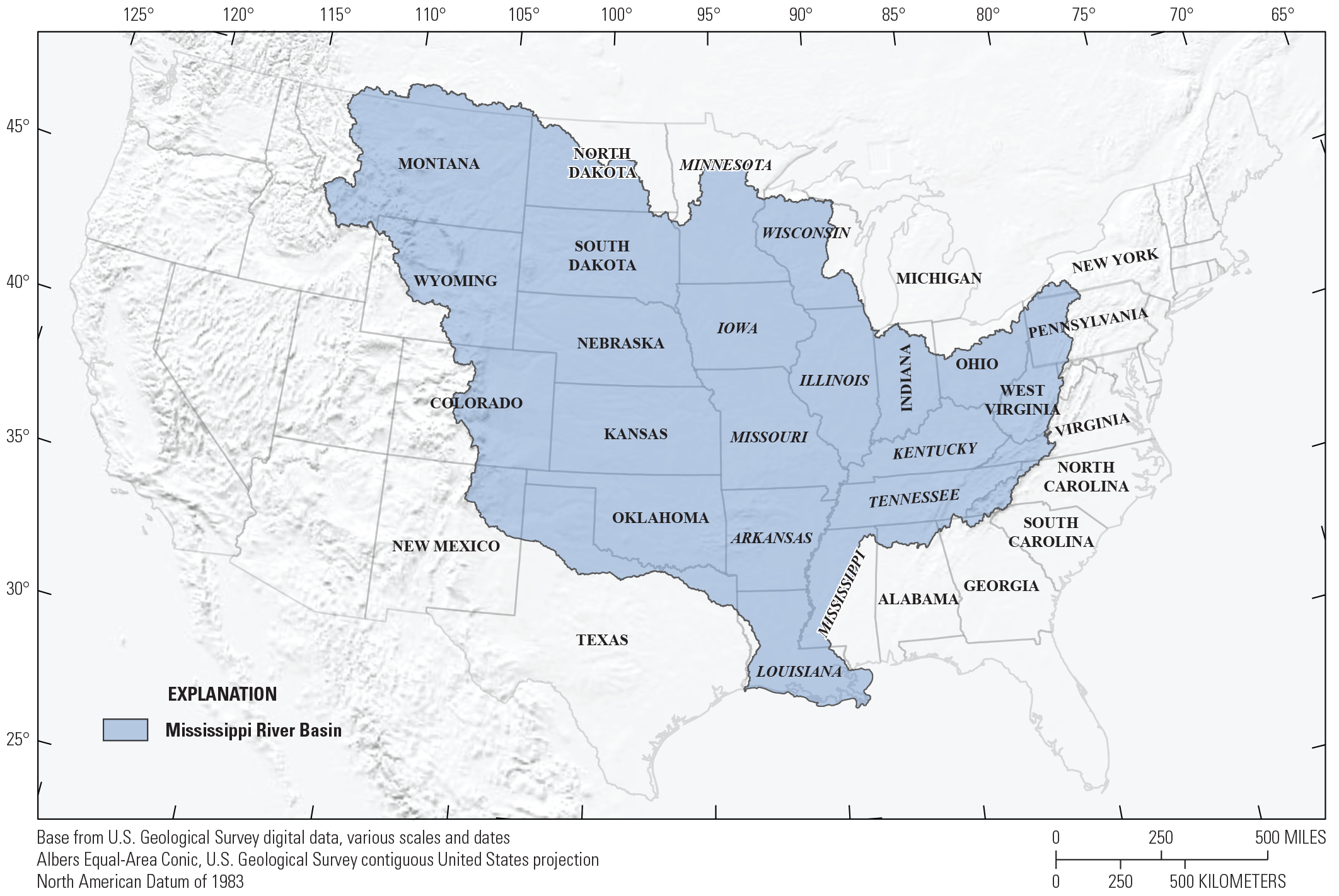
Mississippi River Basin, states of the basin (32) are listed with those along the river (10) in italics.
Although there are no overarching programs that stakeholders can utilize for information, akin to the Great Lakes Restoration Initiative, there are programs throughout the Mississippi River Basin that are making progress on many fronts, including those presented by many of our speakers at the forum. As an example, the Upper Mississippi River Restoration Program has been in place since 1986 (Public Law 99–662, 100 Stat. 4082). This program illustrates the value added by a partnership, in this case between the U.S. Army Corps of Engineers and USGS along with the five States in the upper Mississippi River Basin (Minnesota, Wisconsin, Iowa, Illinois, and Missouri) as well as numerous other partners and the stakeholders. A similar program for the entire Mississippi River Basin would connect resource managers making decisions about infrastructure and other critical needs from the headwaters to the Gulf of Mexico.
Current State of Mississippi River Science
The Mississippi River Science Forum speakers and attendees demonstrated the size and diversity of the Mississippi River Basin’s science and stakeholder community. Science is being executed on all the topics that were specified in the Consolidated Appropriations Act of 2022 (Public Law 117–103, 136 Stat. 490): improving water quality, restoring habitat and natural systems, improving navigation, eliminating aquatic invasive species, and building resilience to natural disasters by a wide range of stakeholders in the basin including many of the participants. There is also science being conducted in many other disciplines across the Mississippi River and its basin, including wildlife disease, climate change, and native species management. In addition to the diversity of science, observations of the river and the basin are part of Tribal culture, and each holds significant historic meaning to Tribal nations. These observations, and the stories that accompany them represent a much longer period of record than any science produced by organizations currently working on the Mississippi River and provide additional insights into how tribal communities live with and rely on the natural resources.
The Mississippi River Science Forum highlighted the lack of coordination across the entire main stem of the Mississippi River. There are examples of intra-agency coordination, but there is no single agency or group coordinating Mississippi River science. There are, however, examples of programs or groups that focus on one topic, like the Gulf Hypoxia Task Force, or on geography, like the Upper Mississippi River Basin Association. Across all the groups working in the Mississippi River Basin, large amounts of data are being generated and a wide range of research materials produced. However, data generated by the various organizations are stored in different locations and formats. Research papers and other materials are being published in a wide range of outlets. There is no single repository in use or identified to promote the findability, accessibility, interoperability, and reusability of the data and research being done on the Mississippi River and its basin.
Opportunities to Improve Data Gaps and Address Areas of Concern
The participants discussed numerous gaps and areas of concern; these ranged from very localized concerns related to a specific project to very broad needs across the entire Mississippi River Basin. Their discussions underscored stakeholder passions for the Mississippi River and basin. A critical issue highlighted was the need to gain a comprehensive understanding of the entire Mississippi River Basin. Tributaries that begin in the far reaches of the Mississippi River Basin can have major impacts on the Mississippi River, necessitating data and research beyond the mainstem of the river.
The biggest take-away from the forum was the need for coordination. Establishing a group, tentatively named the Mississippi River Science Team, could help develop a science plan, facilitate communication progress, expand stakeholder involvement, and develop data standards that focus on findability, accessibility, interoperability, and reusability. Programs like the Great Lakes Restoration Initiative have benefitted from similar structure (Carl and others, 2021). No formal discussion of the structure for a Mississippi River science team occurred during the forum; however, it would likely need to have representatives from a subset of the stakeholders.
Standardized data elements emerged as a shared desire among the stakeholders. Ensuring the findability, accessibility, interoperability, and reusability of data could expand stakeholder engagement, enhance understanding of ongoing and potential accomplishments, and identify opportunities. However, beyond that the stakeholders did not elaborate on what standardized data elements were needed.
Next Steps
The gaps and concerns presented here confirm there are many directions that next steps could building on and highlight that no single stakeholder group is more important than another when it comes to getting science done in the Mississippi River Basin establishing a Mississippi River science team would require coordinated efforts on land management, polices, and objectives, involving the entire stakeholder community. The Mississippi River supports a strong and energetic stakeholder community eager for an increased science presence in the Mississippi River Basin. The stakeholders were grateful for the opportunity, through the forum, to talk about the Mississippi River and its basin. Leveraging the work of the EPA through its development of the Mississippi River Restoration and Resiliency Strategy (EPA, 2022) presents a promising starting point for future actions.
Acknowledgments
The writing team of this paper would like to thank everyone that contributed to the Mississippi River Science Forum that was held on February 15–16, 2023. We would also like to thank the peer reviewers that contributed greatly to the final product. Finally, we would like to thank leadership from the USGS’s Midcontinent and Southeast Regions and Ecosystems and Water Resources Mission Areas for the invaluable support and guidance they provided.
References Cited
Carl, L.M., Hortness, J.E., and Strach, R.M., 2021, U.S. Geological Survey Great Lakes Science Forum—Summary of remaining data and science needs and next steps: U.S. Geological Survey Open-File Report 2021–1096, 4 p., accessed August 2023 at https://doi.org/10.3133/ofr20211096.
U.S. Environmental Protection Agency [EPA], 2022, Mississippi River Restoration and Resiliency Strategy: 52 p., accessed August 2023 at https://www.epa.gov/nps/mississippi-river-restoration-and-resiliency-strategy.
For more information about this publication, contact:
Director, Midcontinent Regional Director’s Office
1992 Folwell Avenue
St. Paul, MN 55108
For additional information, visit:
https://www.usgs.gov/regions/midcontinent
Publishing support provided by the
Rolla Publishing Service Center
Disclaimers
Any use of trade, firm, or product names is for descriptive purposes only and does not imply endorsement by the U.S. Government.
Although this information product, for the most part, is in the public domain, it also may contain copyrighted materials as noted in the text. Permission to reproduce copyrighted items must be secured from the copyright owner.
Suggested Citation
Nelson, J.C., Rebich, R.A., Jankowski, K., Edwards, T.M., Larson, J.H., Robertson, D.M., Sprague, L.A., Stackpoole, S.M., Summers, K.M., Cinotto, P.J., Rydlund, P.H., Churchill, C.J., Daniel, W.M., Mckenna, O.P., Middleton, B.A., Carter, J., Hartley, S.B., Frey, J.W., and Warner, K.L., 2024, U.S. Geological Survey Mississippi River Science Forum—Summary of data and science needs and next steps: U.S. Geological Survey Open-File Report 2024–1053, 4 p., https://doi.org/10.3133/ofr20241053.
ISSN: 2331-1258 (online)
Study Area
| Publication type | Report |
|---|---|
| Publication Subtype | USGS Numbered Series |
| Title | U.S. Geological Survey Mississippi River Science Forum—Summary of data and science needs and next steps |
| Series title | Open-File Report |
| Series number | 2024-1053 |
| DOI | 10.3133/ofr20241053 |
| Publication Date | August 30, 2024 |
| Year Published | 2024 |
| Language | English |
| Publisher | U.S. Geological Survey |
| Publisher location | Reston, VA |
| Contributing office(s) | Midcontinent Regional Director's Office |
| Description | iii, 4 p. |
| Other Geospatial | Mississippi River basin |
| Online Only (Y/N) | Y |
| Additional Online Files (Y/N) | N |