

Phase 1 Technical Implementation Plan for the Expansion of the ShakeAlert Earthquake Early Warning System to Alaska
Links
- Document: Report (7.18 MB pdf) , HTML , XML
- NGMDB Index Page: National Geologic Map Database Index Page (html)
- Download citation as: RIS | Dublin Core
Acknowledgments
We thank Barrett Salisbury of the Alaska Division of Geological and Geophysical Surveys, Bryan Fisher of the Alaska Division of Homeland Security and Emergency Management, and the Alaska Seismic Hazards Safety Commission for their important input during the creation of this plan. We thank the Advanced National Seismic System Steering Committee, chaired by Maureen Long, and the Earthquake Early Warning Working Group for their review of the plan. We acknowledge the help of Brian Mullery, Anna Huryn, and other staff at Corner Alliance in facilitating the development of this plan. As described in appendixes 1 and 2, a number of Alaska stakeholders and monitoring networks contributed valuable insights, and the plan also benefitted from feedback by attendees of the interagency workshop Earthquake Early Warning in Alaska—What Would It Take.
From the U.S. Geological Survey, we also thank Robert de Groot, Jeff McGuire, and Aimee Devaris for their reviews and Gavin Hayes for his guidance.
Executive Summary
The conference report accompanying the fiscal year (FY) 2022 Consolidated Appropriations Act (Public Law 117–103) for the U.S. Department of the Interior and related agencies directed the U.S. Geological Survey (USGS) to “work with the State of Alaska to develop an implementation plan to be completed within two years in order to put ShakeAlert/Earthquake Early Warning in Alaska” (p. 29). Congress included $1 million in the FY 2022 appropriation to conduct this effort.
The USGS Earthquake Hazards Program, along with partner organizations, has developed the ShakeAlert earthquake early warning (EEW) system for the West Coast, which currently operates in California, Oregon, and Washington. The purpose of the system and its alert delivery partners is to reduce the impact of earthquakes and save lives and property by delivering ShakeAlert-powered alerts that are transmitted to the public via mass notification technologies, and by providing more detailed data streams to institutional users and commercial service providers to trigger automated, user-specific, protective actions.
ShakeAlert was designed in such a way that it could be expanded to other U.S. regions with high earthquake risk, after the build-out of seismic and geodetic networks to support ShakeAlert in a specified region is completed and the necessary funding is secured for long-term operation and maintenance.
When an earthquake occurs, seismic waves radiate from the rupturing fault like waves on a pond. It is these waves that people feel as earthquake shaking and that can cause damage to structures. Using networks of ground-motion sensors and sophisticated computer algorithms, ShakeAlert can detect an earthquake seconds after it begins, calculate its location and magnitude, and estimate the resulting intensity of shaking. Early warnings of impending shaking are then sent to people and systems that may experience damaging shaking, allowing them to take appropriate protective actions. Depending on the user’s distance from the earthquake, alerts may be delivered before, during, or after the arrival of strong shaking. There will almost always be a region near the earthquake epicenter where alerts arrive after damaging shaking has begun. The ShakeAlert system updates its ground-motion estimates as an earthquake grows larger.
In response to the FY 2022 congressional direction, the USGS worked with the State of Alaska to devise this implementation plan for ShakeAlert expansion to Alaska. The USGS engaged with the Alaska Division of Homeland Security and Emergency Management (DHS&EM) and the Alaska Division of Geological and Geophysical Surveys (DGGS). A cooperative agreement was awarded to the Alaska Earthquake Center (AEC) at the University of Alaska Fairbanks (UAF) for their contributions to the plan and their work coordinating with other networks in Alaska. The USGS engaged with the Alaska Seismic Hazards Safety Commission (ASHSC) throughout the process. The USGS also held a series of Alaska stakeholder engagements. The process of developing the implementation plan was facilitated by contracted staff from Corner Alliance, which is a government consulting firm.
This implementation plan describes the details and estimates the costs for a Phase 1 expansion of the ShakeAlert system to Alaska. A geographically limited Phase 1 goal was chosen that covers the highest risk and most populated areas of Alaska. The areas proposed encompass the State’s main population centers and 90 percent of the State’s population. This Phase 1 design is considered very challenging and ambitious from the viewpoint of network operators. The lessons learned if this plan is implemented could be used to consider subsequent phases to expand EEW beyond Phase 1 in Alaska in the future.
ShakeAlert is built on the foundation of the sensor networks and data processing infrastructure of the USGS-led Advanced National Seismic System (ANSS). This implementation plan calls for a total of 450 high-quality, real-time EEW-capable ANSS seismic stations in Alaska: 270 new stations, 160 upgraded stations, and 20 existing stations. These seismic station numbers are based on a station spacing of 10 kilometers (km) in urban areas, 20 km in seismic source areas that endanger population centers, and 40 km in other areas. The associated costs also include support for some EEW-capable global navigation satellite system (GNSS) stations, with a focus on improving warnings for large subduction zone earthquakes. For effective EEW, ShakeAlert requires low-latency, high-availability, robust telemetry links to deliver continuous, real-time data from field stations to the data centers.
The Alaska data processing hardware infrastructure would follow the general design for fail-safe operation that is used for the ShakeAlert system on the West Coast. The ShakeAlert architecture uses two independent layers: the production layer for earthquake processing and the alert layer to make alerting decisions and serve alerts to users. This implementation plan includes two geographically separated data centers in Alaska, each with two fully independent production and alert layers using the same system design developed for the West Coast. As of March 2024, the ShakeAlert system is at version 3.0.1, with more advanced versions in the development and testing pipeline. ShakeAlert originally used two algorithms to determine the location and magnitude of earthquakes using seismic data. A third algorithm that can calculate very large magnitudes of very large earthquakes with geodetic data was added in March 2024.
ShakeAlert publishes several data and alert products to meet the needs of different users. All messages include the location of the earthquake, either as a point or a line, and its magnitude. Ground-shaking estimates are published in two forms, as ground-motion contours and a map grid. Providing adequate warning time for strong shaking (the “target threshold”) requires sending alerts at a threshold lower than that strong shaking level (the “alert threshold”). The thresholds for public alerting in Alaska would be a joint USGS and State decision.
To have the greatest benefit, ShakeAlert-powered alerts would be delivered to institutional users and individuals by all practical pathways. The USGS alert layer can support thousands of institutional users and alert redistributors, but the USGS does not have the mission nor the infrastructure and expertise to perform mass notifications to the public or implement automatic actions for end users of the alerts. To meet this need, ShakeAlert recruits private sector “technology enablers” that have the necessary expertise to develop end-user implementations using EEW alerts with the goal of stimulating an EEW industry.
Earthquake early warning alerts are useless if people do not know how to respond to them. Although the alert messages include instructions about what to do (drop, cover, and hold on), alerts are more effective if people have been trained in advance. Messages about ShakeAlert’s capabilities, limitations, and benefits could be integrated with existing earthquake education programs, including State-run programs. Therefore, ShakeAlert would coordinate with both public and private partners and stakeholders through various partnerships and agreements to accomplish consistent and ongoing public earthquake hazard education.
The estimated capital cost of completing the computing infrastructure and sensor networks for the Phase 1 ShakeAlert expansion to Alaska is approximately $66 million in 2024 dollars. The annual operation and maintenance cost of the completed system is estimated to be $12 million per year in 2024 dollars when fully built out.
Introduction
The purpose of this document is to provide an implementation plan for the expansion of the U.S. Geological Survey- (USGS) managed ShakeAlert earthquake early warning (EEW) system to the State of Alaska. In the Department of the Interior, Environment, and Related Agencies Appropriations Act of 2022, the USGS was directed by Congress to work with the State of Alaska to develop an implementation plan for the expansion of the ShakeAlert EEW system to Alaska, and this document fulfills that requirement. Congress provided $1 million of one-time Congressionally Directed Spending/Community Project Funding for this effort.
An EEW system detects earthquakes so quickly that an alert can potentially reach some areas seconds before strong shaking arrives. This can allow for protective actions to be taken. The earthquake’s location and magnitude are rapidly estimated by measuring the first shaking with sensors near the source. The ground-shaking intensity expected across the affected region is then estimated and alerts sent to people or systems in those areas, in some cases before the larger, more damaging shaking arrives. As the earthquake grows, more data become available from additional sensors and the system revises these ground-motion estimates and updates its alerts.
The area close to the epicenter may not receive the alert before strong shaking begins but can still benefit from the information that a significant earthquake is occurring. The size of this “late alert” zone can be minimized by having dense networks with sensors close to the epicenter, fast detection algorithms and alerting software, and rapid alert-delivery technologies. More distant locations will have more time to act but will typically experience less intense shaking.
The USGS Earthquake Hazards Program (EHP), along with partner organizations, originally developed the ShakeAlert EEW system for the highest risk areas of the U.S. West Coast: California, Oregon, and Washington. In Canada, Natural Resources Canada (the USGS sister organization) is working with the USGS to create an integrated ShakeAlert center in Canada and coordinate cross-border alerts.
The design and costs of the ShakeAlert system on the West Coast have been described in the 2018 Implementation Plan (Given and others, 2018) and funding to develop and operate the system has been provided by the USGS, States, and other resources. ShakeAlert public alerting was rolled out in 2019 in California and 2021 in Oregon and Washington. The USGS utilizes partnerships with companies and end-user organizations to execute the delivery of ShakeAlert- powered alerts. The ShakeAlert system on the West Coast was developed as a new product within the USGS Advanced National Seismic System (ANSS) that leverages the existing Federal and State investments in ANSS seismic and geodetic monitoring. The purpose of ShakeAlert is to reduce the impact of earthquakes and save lives and property by providing alerts that are transmitted to the public via mass notification technologies and more detailed data streams to institutional users and commercial service providers to trigger automated user-specific protective actions.
ShakeAlert has been designed so that it can be expanded geographically to other U.S. regions with high earthquake risk, after the build-out of seismic and geodetic networks to support ShakeAlert in a specified region is completed (both through upgrades of existing stations and installations of new stations) and the necessary funding is secured for long term operation and maintenance (O&M).
In response to the FY 2022 Congressional Direction, the USGS worked with the State of Alaska to devise this implementation plan for ShakeAlert expansion to Alaska. The USGS engaged with the Alaska Division of Homeland Security and Emergency Management (DHS&EM) and the Alaska Division of Geological and Geophysical Surveys (DGGS). A cooperative agreement was awarded to the Alaska Earthquake Center (AEC) at the University of Alaska Fairbanks (UAF) for their contributions to the plan and their work coordinating with other networks in Alaska. The USGS engaged with the Alaska Seismic Hazards Safety Commission (ASHSC) throughout the process. The USGS also held a series of Alaska stakeholder engagements, as described in appendixes 1 and 2. The process of developing the implementation plan was facilitated by contracted staff from Corner Alliance, which is a government consulting firm.
ShakeAlert Vision
The vision of the USGS is to reduce the impact of earthquakes and save lives and property in the United States and its territories by developing and operating the public ShakeAlert EEW system for high-risk regions.
ShakeAlert Mission
The USGS, along with partner organizations, will develop and operate the ShakeAlert EEW system, called ShakeAlert, for the highest risk areas of the United States and its territories. The ShakeAlert system will leverage the current earthquake-monitoring capabilities of the ANSS (U.S. Geological Survey, 2017) and provide ShakeAlert Messages free of charge to the public, via partnerships with delivery providers, and to specialized users, including commercial service providers, for use in user-specific applications. The USGS will promote and help coordinate public education and training about the ShakeAlert system and its capabilities, limitations, and benefits to users. This mission will be accomplished in cooperation with both public and private partners and stakeholders through various partnerships and agreements.
Goal for This Implementation Plan
The goal of this implementation plan is to outline a potential model for the expansion of the ShakeAlert system to the most highly populated parts of Alaska that have the greatest risk from earthquake shaking. The system would provide the necessary information allowing the USGS to publish ShakeAlert Messages for potentially damaging earthquakes to power alerts to the public in parts of Alaska and make available rapid earthquake and ground-motion estimates to license-to-operate (LtO) partners as soon as the ShakeAlert system, its products, and its parametric data meet minimum quality and reliability standards in regions of Alaska. Refer to “Phase 1 Rollout Strategy for Alaska” section for further details.
Authorities
The USGS was established by the Organic Act of March 3, 1879 (20 Stat. 394, 43 U.S.C. 31 et seq.). The Earthquake Hazards Reduction Act (Public Law 95–124 and subsequent reauthorizations) designates the USGS as the Federal agency responsible for providing notifications of earthquakes. The USGS is tasked with developing an EEW system in the United States in the Earthquake Hazards Reduction Act of 1977 (42 U.S.C. 7701 et seq.), as amended through Public Law 115–307. The most recent National Earthquake Hazards Reduction Program (NEHRP) authorization (Public Law 108–360) notes the loss-reduction value of early warning systems (sec. 7701), specifically calls for disseminating warnings of earthquakes (sec. 7702) and authorizes the USGS to establish and operate the ANSS “in order to enhance earthquake research and warning capabilities” (sec. 7707). Appropriations language supporting an “earthquake early warning prototype system on the West Coast” first began in FY 2014 (Public Law 113–76; refer to 160 Congressional Record H974). The Federal Emergency Management Agency (FEMA) has granted the USGS the authority to alert the public through its Integrated Public Alert and Warning System (IPAWS). The USGS authority for engaging in technology transfer is under the provisions of the Stevenson-Wydler Technology Innovation Act of 1980 (15 U.S.C. 3710(a)), as amended.
The Physics of the Problem in Alaska
EEW systems, such as ShakeAlert, are designed to detect multiple types of earthquakes. The density and style of instrumentation can be configured to match the earthquakes that are anticipated. Alaska’s earthquakes vary by region and cover the full suite of earthquake styles (fig. 1). Much of that activity can be traced to the motion of two tectonic plates—the North American Plate and the Pacific Plate. Relative to North America, the Pacific Plate is drifting north and westward into Alaska.
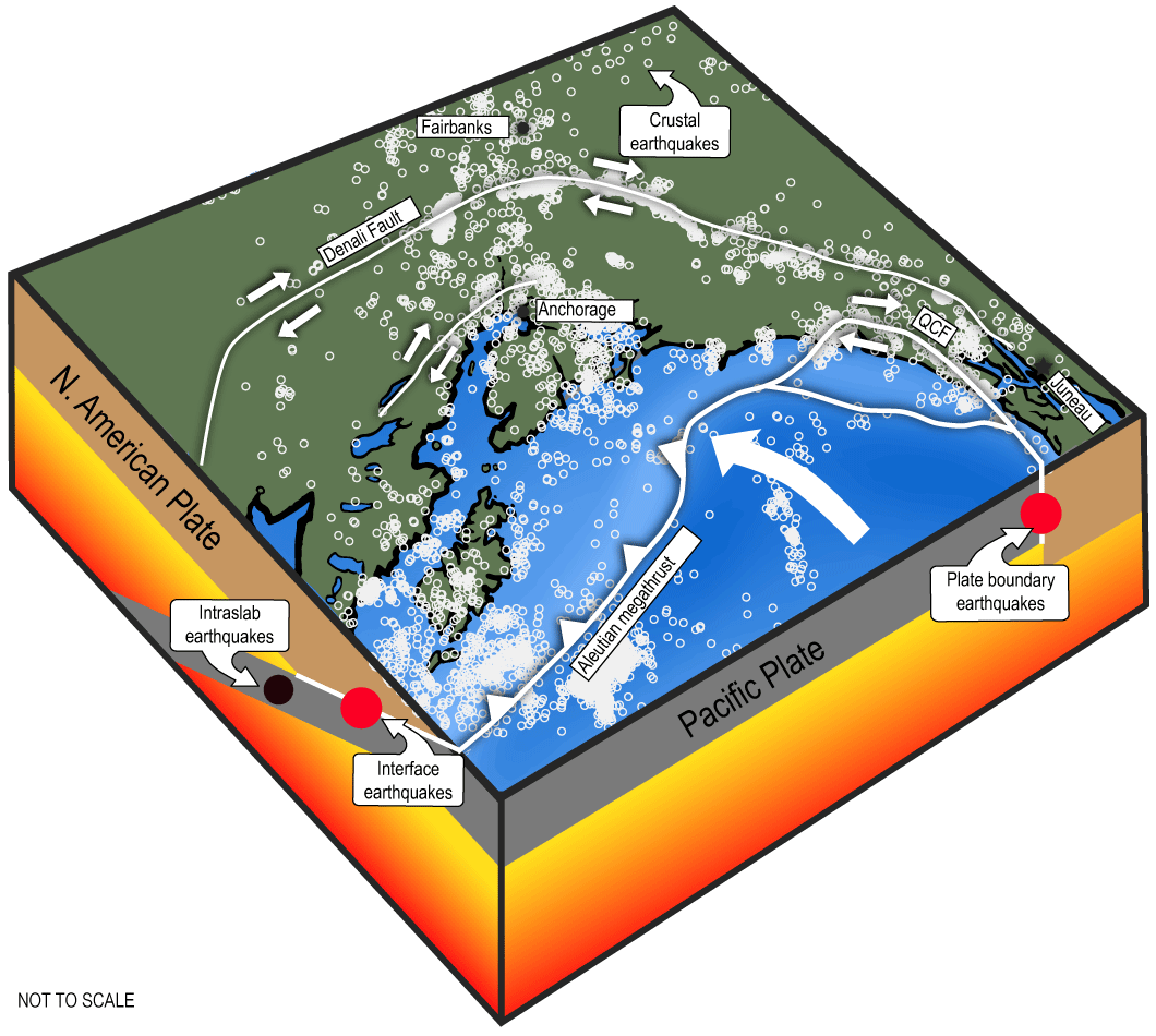
Illustration of earthquake sources in Alaska. Four categories of earthquakes are shown: shallow crustal earthquakes (most widespread and common); earthquakes that occur on the subduction zone interface (interface earthquakes) in southern Alaska (the subduction zone interface hosts the largest earthquakes in Alaska, called “megathrust earthquakes”); earthquakes that occur along the strike-slip plate boundary in southeast Alaska (plate boundary earthquakes); and earthquakes that occur inside the down-going oceanic plate (intraslab earthquakes). White circles represent historic earthquake locations (depths less than 30 kilometers and magnitudes 3 or greater). Abbreviation: QCF, Queen Charlotte Fault.
Along the southeast panhandle of Alaska, these two plates grind past one another, creating the Queen Charlotte (offshore) and Fairweather (onshore) Fault systems. The strike-slip earthquakes on this plate boundary are similar to those on the well-known San Andreas Fault system in California. Over the past century, the Queen Charlotte-Fairweather Faults have generated six magnitude (M) 7.1+ earthquakes, including the 2013 M7.5 Craig earthquake, the 1972 M7.6 earthquake that generated strong shaking in Sitka, and the 1958 M7.8 earthquake on the Fairweather Fault that caused the great Lituya Bay tsunami (Ochoa Chavez and Doser, 2020). Many earthquakes in this area occur off the coast, posing challenges for monitoring systems.
Along much of the rest of the southern coast of Alaska, the Pacific Plate collides directly with the North American Plate. The oceanic Pacific Plate is thrust under mainland Alaska and the Aleutian Islands in a process known as subduction, which causes some of the largest earthquakes in the world. These subduction interface earthquakes can be complicated events that start in one place and rupture for several hundred kilometers (km) over a period of minutes. The M9.2 Great Alaska Earthquake in 1964 began under Prince William Sound and ruptured more than 500 km toward Kodiak Island over a duration of four minutes. The extended rupture length of great subduction-zone megathrust earthquakes requires an EEW system that can track and update information as the earthquake grows.
As the slab of the Pacific Plate descends deep under Alaska, it is squeezed and bent, which also generates earthquakes. These so-called intraslab earthquakes occur along the entire along-arc length of the subduction zone to depths of up to 200 km. Magnitude 7+ earthquakes of this type occur on average once per decade somewhere along the subduction arc. The best known of these is the 2018 M7.1 Anchorage earthquake, which generated violent ground motions across some of Alaska’s most populous regions. These types of earthquakes dominate the hazard for Anchorage, and it is challenging for an EEW system to provide long warning times for them (for example, McGuire and others, 2021). The deep nature of intraslab earthquakes can decrease potential warning times because the wavefronts hit a large region simultaneously; this deep nature also challenges algorithms for estimating shaking intensity by forcing them to consider earthquakes in three dimensions.
The subduction of the Pacific Plate creates a suite of shallow crustal faults hundreds of km inland as well. These faults, and the earthquakes they generate, are the response to the slow compression of Alaska driven by complexities in the subduction zone. The best known of these is the Denali Fault. In 2002, a 300-km section of this fault ruptured in a M7.9 earthquake that was the largest inland earthquake in North America in 150 years. Crustal faults of different styles are present throughout much of Alaska, although in many places they are poorly mapped. Earthquakes on crustal faults in urban areas present a special challenge for EEW systems because there is very little time for warning in regions close to the earthquake epicenter before the strong shaking arrives.
It can be challenging to determine the threats for these different styles of earthquakes. The most accepted approach is to combine the various earthquake threats into an assessment of probabilistic seismic hazard. Hazard values provide a way to make a quantitative assessment of the earthquake threat in a manner that accounts for all earthquake sources. The U.S. National Seismic Hazard Model was updated in 2023 for all 50 States, using new science on seismicity, fault ruptures, ground motions, and probabilistic techniques to produce a standard of practice for public policy and other engineering applications (Petersen and others, 2024).
All of these complexities combine to make designing an EEW system for Alaska challenging. However, the high rates of varied seismicity also make Alaska an excellent proving ground for evolving techniques and instrumentation. ShakeAlert lessons that would undoubtedly be learned in Alaska should benefit the entire U.S. EEW system.
It should be noted that while the shaking from earthquakes can be damaging, the secondary effects of shaking, which depend on the environment, are also impactful. Sedimentary basins magnify the ground shaking and certain types of sediments can spread and liquify, causing damage to roads, bridges, and other structures. In mountainous areas, landslides are frequently triggered during large earthquakes. In coastal Alaska, tsunamis are an ever-present threat in the minutes and hours following large earthquakes.
Benefits and Uses of ShakeAlert in Alaska
A few seconds of advance warning before the arrival of damaging shaking may not seem like much, but it allows extra time for people to take protective actions, especially if they have been trained in advance. ShakeAlert can also be used to trigger automated actions that can prevent injury or death, reduce immediate damage to infrastructure, and speed recovery after earthquakes.
The USGS met with 26 stakeholder groups to gauge the interests of how an EEW system would be used in Alaska and gain insight into expectations, recommendations, and concerns (appendix 1), and an interagency workshop was held called Earthquake Early Warning in Alaska—What Would It Take (appendix 2). Overall, the prospect of implementing the ShakeAlert EEW system in the State was viewed positively by stakeholders. Some believed that ShakeAlert in Alaska would be used dominantly for personal protection, enabling people to take protective actions (for example, drop, cover, and hold on), and saw less potential for ShakeAlert triggering automated actions in Alaska for infrastructure protection. Some raised concerns about the ShakeAlert’s effectiveness being hindered by limitations of Alaska’s cellular phone and telecommunications networks, noting that coverage is best in more populated areas but can deteriorate greatly in rural areas. Many noted the risks associated with over-alerting, and potential confusion with tsunami warnings and recommended that, if ShakeAlert were extended to Alaska, the USGS and the National Oceanic and Atmospheric Administration (NOAA) coordinate their earthquake and tsunami warning efforts so that education and messaging could be optimized.
Additionally, in 2016, Governor Bill Walker’s office asked the ASHSC to lead an effort to compile a written summary of the benefits of improved earthquake monitoring in Alaska and the potential implementation of EEW (Alaska Seismic Hazards Safety Commission, 2016).
The potential benefit of ShakeAlert can also be analyzed in the context of the region’s risk. Earthquake risk is the consequence of the interaction between the hazard and the characteristics that make people and places vulnerable and exposed. Alaska experiences very high earthquake hazards, which are coupled with low exposure due to its small population. Estimates of the losses from earthquakes in the United States are provided in publication 366 by FEMA (2023) and can aid in understanding a region’s risk. Annualized earthquake loss (AEL) is an estimate of the long-term value of earthquake losses due to casualties and building-related direct economic losses in any single year in a specified geographic area; the annualized earthquake loss ratio (AELR) is the AEL as a fraction of the replacement value of the building inventory and is useful for comparing the relative risk of different regions or events. The total AEL across the United States is $14.7 billion per year, and the AEL in Alaska is $120 million per year. These numbers are based on the 2018 estimate of the National Seismic Hazard Model for the lower 48 and a 2007 model for Alaska. Alaska ranks as the 12th highest State in terms of its AEL but moves up to 7th highest in terms of its AELR,1 which reflects a higher relative impact of earthquakes on these communities. Sixty-eight percent of Alaska’s AEL is concentrated in the Anchorage metropolitan area. It is important to note that these estimates are for damage from shaking and do not include the impacts of any accompanying secondary effects.
Alaska ranks as the 12th highest State in terms of annualized earthquake loss (AEL), and the 11 States with higher AEL are (1) California, (2) Washington, (3) Oregon, (4) Utah, (5) Puerto Rico, (6) Nevada, (7) Tennessee, (8) South Carolina, (9) Missouri, (10) Illinois, and (11) Hawai‘i. Alaska ranks as the 7th highest State in terms of annualized earthquake loss ratio (AELR) and the 6 States with higher AELR are (1) California, (2) Oregon, (3) Washington, (4) Puerto Rico, (5) U.S. Virgin Islands, and (6) Utah (FEMA, 2023, table 3-1).
ShakeAlert Earthquake Early Warning System Strategy
The USGS has overall responsibility for the ShakeAlert system and works closely with cooperating project partners to achieve the goals of the system. Core system management and operations, testing, coordination of communication, education, outreach activities, and overall project management are performed by USGS project staff, known as ShakeAlert Central. Led by a national EEW coordinator, ShakeAlert Central is in Pasadena, Calif.
The ShakeAlert system on the West Coast leverages the existing earthquake-monitoring capability and expertise of ANSS regional seismic networks, and this same strategy would be used for any Alaska expansion. In addition to seismic networks, the USGS also utilizes data from real-time global navigation satellite systems (GNSS) networks. By evolving existing Federal- and State-supported capabilities, the USGS and partners could build out the ShakeAlert system in Alaska incrementally, building on the foundation of the substantial Federal and State Government investment in sensor networks, data telemetry systems, data processing centers, and software for earthquake monitoring.
Phase 1 Rollout Strategy for Alaska
This implementation plan describes the details and estimates the costs for a Phase 1 expansion of the ShakeAlert system to Alaska. The USGS engaged with the Alaska DHS&EM, the Alaska DGGS, and ASHSC to decide on the design.
Given the size of the State, the geographic distribution of population and infrastructure, and the characteristics of its earthquake risk, a statewide system would not be well justified by a cost-benefit analysis. Therefore, a geographically limited Phase 1 goal was chosen that covers the highest-risk and most-populated areas of Alaska (fig. 2). The areas proposed encompass the State’s main population centers (90 percent of the State’s population) and certain critical infrastructure. It also minimizes the need to expand current seismic network coverage. This Phase 1 design is considered very challenging and ambitious from the viewpoint of network operators. The lessons learned if this plan is implemented could be used to consider possible subsequent phases to further expand EEW in Alaska in the future.
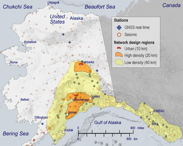
Seismic network coverage design (low-density, high-density, and urban regions with 40-kilometer (km), 20-km, and 10-km station spacing, respectively) for the Phase 1 ShakeAlert earthquake early warning (EEW) system in Alaska. Circles are locations of existing seismic sites and diamonds are real-time geodetic sites. Abbreviation: GNSS, global navigation satellite system.
The rollout of public alerting in Alaska associated with this Phase 1 plan would be regionally limited and would begin only when seismic network density in the selected region is built out sufficiently to ensure timely and reliable EEW. This is because stations must be close to faults that generate earthquakes in order to enable rapid alerts (especially when these faults are in urban areas).
Consistent with the design of the system on the West Coast, ShakeAlert seismic station coverage in Alaska is variable and based on both the hazard and the population density. ShakeAlert is able to alert faster for earthquakes initiating in areas with higher density station coverage.
ShakeAlert low-density region (station spacing about 40 km)—This area (low-density region in fig. 2) has a sufficient level of coverage so that earthquakes occurring anywhere in this region can be detected and alerted by ShakeAlert. The system also alerts on earthquakes that occur outside of this area but are close enough to generate strong ground motion in the ShakeAlert region. That includes offshore earthquakes on the subduction zone, offshore earthquakes along southeast Alaska, and large ruptures nucleating west of Kodiak Island.
All of this region is considered a high seismic hazard. This region is capable of nucleating large earthquakes with the greatest potential to impact areas a few hundred kilometers away.
ShakeAlert (station spacing about 20 km)—Earthquakes occurring in these regions (high-density regions in fig. 2) are detected and alerted by ShakeAlert more rapidly owing to the closer station spacing. This ShakeAlert region meets all three of the following conditions:
-
1. High estimated seismic hazard (roughly 2 percent in 50-year peak ground motion greater than (>) 50 percent standard gravity (g).
-
2. Strong, shallow earthquakes that nucleate inside the region (crustal or slab).
-
3. Considerable urban, military, or private infrastructure.
Urban ShakeAlert (station spacing about 10 km)—Seismic station density is highest near the Anchorage and Fairbanks urban areas. Earthquakes offshore can be challenging for ShakeAlert to locate precisely. The design also includes support for 10 arrays (with location to be determined), which can provide accurate information to improve ShakeAlert performance for offshore events.
Upgraded stations along the Alaska Peninsula and Aleutian Islands—The plan also includes support to add 20 strong-motion sensors to some existing seismic stations on the Alaska Peninsula and Aleutian Islands in order to improve traditional earthquake monitoring for this region and to collect data that would help with the evaluation of any possible future ShakeAlert expansion.
Major System Components
ShakeAlert is designed as a set of geographically distributed but interconnected components and subsystems to detect earthquakes so quickly that alerts can be sent to people and machines rapidly enough to allow them to take protective actions before strong shaking arrives. The main components of the system include message generation, supporting tasks, and alert services and user applications, whose main components are summarized below and discussed in more detail in the following sections.
Message generation includes all actions, from detecting an earthquake to generating alerts:
-
• Sensor networks—Integrated networks of seismic and geodetic sensors focused on potential earthquake source areas and population centers to record ground motions generated by earthquakes. Seismic stations use sensitive inertial sensors (masses and springs) to measure ground motion as velocity or acceleration, while geodetic stations use high-precision GNSS receivers to measure ground displacement.
-
• Field telemetry—Data telecommunications systems are required to reliably transport data from field sensors to regional alert centers with minimal latency.
-
• Processing and alert centers—Physical infrastructure with hardened, secure data processing capabilities to receive and manage ground-motion data and run the scientific algorithms and alert generation functions. These functions may be hosted in cloud data centers.
-
• Scientific algorithms—Sophisticated scientific software algorithms to analyze seismic and geodetic data to rapidly detect earthquakes, reject non-earthquake signals, determine earthquake characteristics, and estimate the resulting spatial distribution of ground-motion intensities.
-
• Alert generation—Rules and software to evaluate and manage these scientific results, decide if ShakeAlert products should be created and to whom they should be served, create the products, and serve them to technical users and public alert distribution providers.
Supporting tasks include steps to operate and improve the system:
-
• Network operations and maintenance—Monitor and maintain the seismic and geodetic networks and their telemetry infrastructure to ensure the rapid, reliable flow of ground motion information to the processing and alert centers.
-
• Operations—Continuously monitor the operation of the system, maintain the system’s cybersecurity, catch and handle problems, and perform maintenance of its hardware, operating system, and software infrastructure.
-
• Testing and performance monitoring—Facilities to continuously evaluate the performance of the system, refine and tune algorithms and modules, and assess new methods and system changes.
-
• Research—Ongoing research in seismology, geodesy, technology, and social science to improve the system’s performance and take advantage of new scientific and technical advances.
Message services and user application address serving alert messages to end users, communicating with and educating end users, and fostering uses of ShakeAlert:
-
• Message services—Facilities to serve rapid, reliable alert products, including event messages, updates, status, and follow-up messages to technical users and the public. Although ShakeAlert Messages and follow-up messages are generated by the system, the USGS depends on the capabilities of other agencies and private sector partners to tailor and distribute these alerts and messages for their clients and the public.
-
• Communication, education, outreach, and technical engagement—Effective communication and education about the ShakeAlert system and its benefits, recruitment of end users and licensed technology operators, and outreach to stakeholders, decisionmakers, and the public.
As the system is developed, work on each of these components of the system can proceed independently of progress on the others.
Alaska Sensor Networks
Alaska has a history of regional earthquake monitoring dating back to the early 1970s, when the first regional seismic stations were installed in the wake of the M9.2 1964 Great Alaska Earthquake as a cooperative effort between the USGS, the Geophysical Institute at the University of Alaska Fairbanks, and the U.S. Air Force. Currently over 600 ground-motion sensors are in operation in Alaska that are maintained by several State and Federal agencies (refer to sections below for further details).
Several factors set Alaska apart from other regions operating earthquake monitoring sensor networks. Weather conditions typically limit the field season to a 140-day-long window from mid-May to mid-October. Field transportation is a major challenge in Alaska. Stations can be divided into three broad categories based on options for moving supplies and access: (1) road-side stations accessed by ground vehicle, (2) stations located in or near communities or remote airstrips reached via commercial fixed-wing air service, or (3) stations that require a helicopter to access. The geography and infrastructure of Alaska require that most non-urban stations be accessed via helicopter. Efficient field operations generally require that field teams prepare shipments of batteries, solar panels, tools, and other equipment months in advance of a trip. These critical supplies are pre-positioned at regional maintenance hubs, which are typically cities or villages with sufficient infrastructure (for example, lodging, fuel) to support technical field activities. These materials are moved via truck, air freight, barge, helicopter sling loads, or even chartered fixed-wing flights to remote airstrips.
There are similar challenges with data telemetry, as described in the “Field Telemetry” section below. All these factors lead to Alaska’s sensor networks being more expensive to operate than those in the contiguous United States.
Existing Federal- and State-supported monitoring networks serve multiple purposes and furnish ground-motion data for a variety of products used for science, engineering, situational awareness, and public safety; however, existing networks are not sufficient for ShakeAlert needs.
Seismic Stations
This implementation plan entails a modern network of 450 high-quality, real-time seismic stations in Alaska which can be built on the foundation of the existing seismic monitoring networks (table 1 and fig. 2).
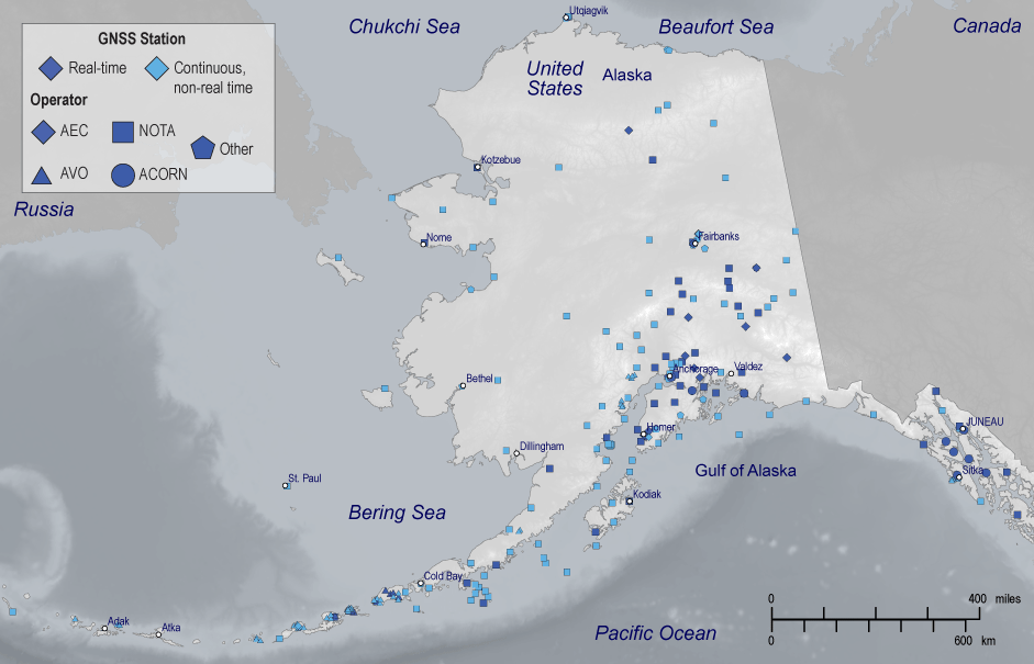
Several organizations currently operate approximately more than 700 seismic stations across Alaska (fig. 3); however, only about 20 of these can be used for EEW without upgrades. Most existing stations lack strong-motion sensors, robust power systems, and the data telemetry bandwidth, speed, and reliability required for early warning. Also, the station spacing is too sparse in most areas to support effective EEW. The AEC at the University of Alaska Fairbanks (with funding from the USGS, the State of Alaska, NOAA, and other sources) is the ANSS authoritative regional seismic network in Alaska and currently operates about 450 seismic stations distributed over the entire State (fig. 2). The USGS National Strong Motion Project (NSMP) operates more than 50 stations clustered mostly in urban areas of Alaska. The USGS Albuquerque Seismological Laboratory operates five stations as part of the U.S. National Seismic Network, also known as the ANSS backbone network. The USGS Volcano Hazards Program’s Alaska Volcano Observatory (AVO) operates about 200 seismic stations to monitor volcanoes. AVO stations are located around active volcanoes stretching from the northern Cook Inlet region in southern Alaska to the western Aleutians. The NOAA National Tsunami Warning Center, located in Palmer, Alaska, operates 14 seismic stations and also ingests seismic data from other seismic networks to rapidly detect and characterize large earthquakes that have the potential to generate tsunamis.
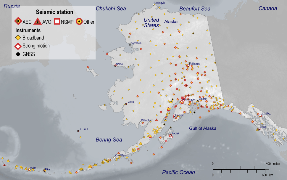
Map of active seismic stations in Alaska as of April 2024. Network identifiers are as follows: AEC, Alaska Earthquake Center; AVO, Alaska Volcano Observatory; NSMP, National Strong Motion Project. Stations labeled “Other” include those operated by the National Oceanic and Atmospheric Administration (NOAA), the Air Force, and the Global Seismographic Network. Abbreviation: GNSS, global navigation satellite systems.
The USGS estimates that build-out of a modern 450-station seismic network needed for the Phase 1 expansion of ShakeAlert in Alaska would require 270 new stations, upgrades to 160 existing stations by adding strong-motion sensors and (or) improvements to power and communications systems, and use of 20 existing EEW-ready stations (table 1).
ShakeAlert requires a network of seismic stations of two different types. All stations would have strong-motion accelerometers, which stay on scale for the strongest shaking, but about 25 percent of these stations would also have more sensitive broadband sensors. Both strong-motion and broadband sensors have three components to record three-dimensional motion (vertical, north-south, east-west). Strong-motion sensors can be installed in existing structures where they are available. Figure 4 shows schematic drawings of ShakeAlert seismic station designs for remote areas of Alaska. All sites that are not installed in an existing structure must have an enclosure to house power systems, communication devices, data digitizers, and other electronics. New or upgraded strong-motion-only sites would have accelerometers in shallow, hand-dug insulated vaults, whereas sites with co-located broadband sensors would have both sensor types integrated as a single package installed in an 8-foot-deep steel-cased post hole. Portable drills that have been specially designed to install post holes at remote seismic sites are available through an Alaska drilling company. This sensor placement design would be applied to both new sites and existing sites that require strong-motion instrumentation upgrades.
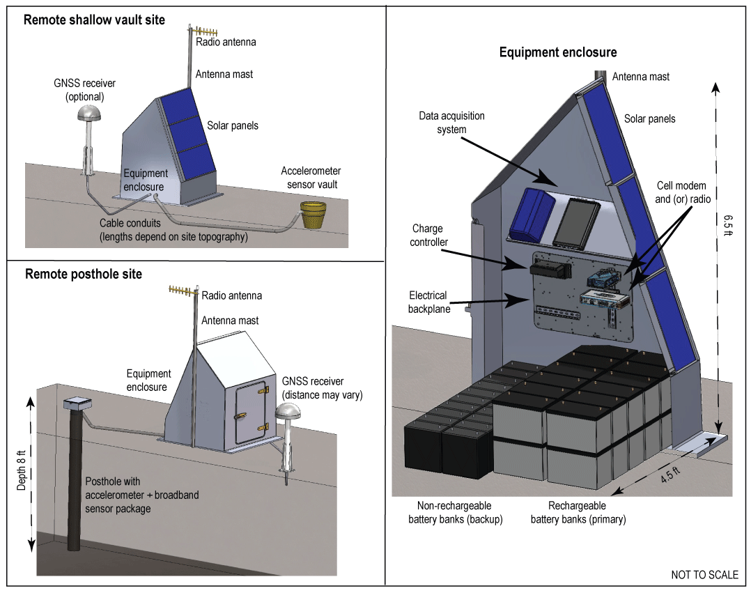
Schematic drawing of a proposed remote seismic station for ShakeAlert in Alaska. The infrastructure components are tailored to different combinations of seismic and global navigation satellite system (GNSS) instrumentation. Each site would include an accelerometer, and 25 percent of sites would have a co-located broadband sensor. A co-located GNSS receiver is an optional addition to seismic sites of any configuration. Equipment enclosures house data acquisition and power and telecommunication systems; solar panels are mounted on the south-facing wall. Images are not to scale. Abbreviation: ft, feet.
Site permitting presents a challenge for the build-out of seismic networks for ShakeAlert and is important to include in the cost estimates. In many cases, deployment at a site could be subject to stringent regulations, including those set by the National Environmental Policy Act (Public Law 91–190, 83 Stat. 852 42 U.S.C.; NEPA), the Endangered Species Act (Public Law 93–205; ESA), and the National Historic Preservation Act (Public Law 89–665; NHPA), which make obtaining permits to upgrade or install hundreds of permanent stations costly and time consuming. NEPA, ESA, and NHPA requirements apply on Federal lands, and on private lands if Federal funds are used for the work. Obtaining permits for both new and upgraded stations can cause significant expense and delays to the station build-out.
Seismic stations need continuous power for sensor and communications components. Most existing seismic stations in Alaska are “free field” (that is, remote from population centers and other infrastructure); therefore, they require autonomous power systems. Most operators rely on solar-charged banks of batteries (lithium or lead-acid) to power the sites. Large snow loads, icing, and long, dark winters in Alaska can make depending on solar power risky. Critical sites may have a secondary source of power such as non-rechargeable aircell batteries that take over when the primary solar-charged bank becomes exhausted. This second type of battery must be replaced every 2 to 3 years. When possible, stations rely on host power sources (for example, schools, fire stations, office buildings, or private residences). A small number of stations are co-located with State microwave towers, or other communication service providers, and can connect directly to direct current (DC) power supplied by those providers.
The lead-acid battery systems last a decade or more at sites with good charging year round. Based on this, AEC’s strategy is to replace these batteries at roughly 10 percent of field sites each year (8 to 10 sites). The lithium battery systems that power many former USArray sites (about 100 across the entire State that are currently operated by AEC), are still in reasonably good condition and operators have not yet begun to replace them. The oldest lithium battery systems are now in their seventh year of operation. AEC has also begun to deploy lithium batteries at a small number of non-USArray sites. Although they introduce some logistical and cost challenges, lithium technologies could be an important component of sensor network operations in Alaska.
ShakeAlert requires a higher percentage of station uptime than routine ANSS seismic monitoring, making it relatively intolerant of power outages at remote sites. As a result, most existing power systems would need to be upgraded or expanded, and new and alternative power sources may be required. This could increase the expense of designing, installing, and maintaining power systems. One possible solution is to use banks of solar-powered lead-acid batteries that are larger than those typically used, with backup provided by non-rechargeable aircells.
Global Navigation Satellite System Stations
Seismic-only ShakeAlert algorithms may underestimate the magnitude of large earthquakes: The Earthquake Point-source Integrated Code (EPIC) algorithm saturates at around M7.0 (Chung and others, 2019) and Finite-Fault Rupture Detector (FinDer) saturates around M9.0 (Böse and others, 2023). Real-time, high-precision, high-rate global navigation satellite system (GNSS) stations can faithfully record the large, permanent ground displacements that accompany major earthquakes: Incorporation of GNSS into ShakeAlert thus can improve and speed up determination of magnitude and fault rupture extent for large earthquakes. The ShakeAlert system on the West Coast recently added an algorithm known as Geodetic First Approximation of Size and Time-Peak Ground Displacement (GFAST-PGD) that uses GNSS data to contribute magnitude estimates to ShakeAlert (Murray and others, 2023). For ShakeAlert in Alaska, GNSS stations will be particularly important to properly characterize large megathrust earthquakes on the Alaska-Aleutians subduction zone.
The ShakeAlert system on the West Coast currently ingests GNSS data streams that are processed in real time at Central Washington University using their Fastlane software (Melbourne and others, 2021). This processing combines raw satellite observations (satellite-GNSS station distance and signal phase) from the field receivers with precise timing and satellite orbit information to calculate the time-varying position of the station with high precision. In addition, EHP has an interagency agreement with the National Science Foundation (NSF) to support the EarthScope Consortium to operate a real-time GNSS data delivery architecture that provides high-throughput, high-availability, fault-tolerant, and permanent data storage for ShakeAlert. The system can also distribute GNSS position changes using publish-subscribe messaging systems (for example, Kafka, Pulsar, NATS.io), affording reliable and redundant future-proof system architecture deployed in a cloud environment. Processed data from EarthScope-operated GNSS sites are provided to ShakeAlert via this architecture to minimize points of failure between the GNSS data processing and the ShakeAlert data centers.
Ultimately, ShakeAlert may deploy the real-time GNSS Fastlane processing software in this cloud architecture to attain further robustness if cloud hosting facilities and bandwidth in the State will support it. The use of cloud hosting services outside of Alaska could result in operational risk because long-haul data connections introduce delays and fragility; however, it is warranted in the case of GNSS because of the efficiencies gained by centralized processing and quality monitoring and the fact that within the ShakeAlert design GNSS does not affect the speed of alerting in the early stages of an event detection.
Within Alaska, there are currently about 250 permanent geodetic stations operated by several organizations (fig. 5). About 130 of these are part of the NSF-supported Network of the Americas (NOTA) operated by the EarthScope Consortium. AVO operates about 55 sites, the majority of which are in the Aleutian Islands, with several sites located in the Cook Inlet region of southern Alaska, and some in southeast Alaska. The State of Alaska recently began to develop the Alaska’s Continuously Operating Reference Network (ACORN), a statewide, real-time GNSS network for use in surveying, mapping, and science. It has installed about 20 stations. The University of Alaska and AEC jointly operate 18 GNSS stations, some of which are co-located with seismic sites. Many of the other GNSS sites operated by AVO and EarthScope are also co-located with seismic stations. AEC plans to continue expanding its GNSS footprint by adding new GNSS sites to some of its existing seismic stations.
Map of continuous global navigation satellite system (GNSS) stations in Alaska as of April 2024. Network identifiers are as follows: AEC, Alaska Earthquake Center; AVO, Alaska Volcano Observatory; NOTA, National Science Foundation’s Network of the Americas operated by EarthScope; ACORN, Alaska’s Continuously Operating Reference Network, State of Alaska GNSS reference network.
The key components of a GNSS installation include an antenna with unimpaired skyview mounted on a monument that is rigidly affixed to the ground, a receiver that records and transmits satellite signals, and supporting power and telemetry infrastructure. Many existing GNSS stations lack real-time telemetry, and field instrumentation and power and telemetry for some existing GNSS stations would need to be upgraded for ShakeAlert. To the maximum possible extent, new GNSS instrumentation would be co-located with seismic instruments to leverage permits and site infrastructure and reduce the number of field locations to be maintained. This colocation strategy would also reduce the cost of maintaining remote geodetic stations in Alaska.
This implementation plan calls for some additional real-time GNSS stations with specific focus on improving the generation of ShakeAlert-powered messages for great-sized (M8+) subduction zone earthquakes.
Field Telemetry
The seismic and geodetic networks in Alaska are 100 percent digital, but there are significant telemetry challenges to reliable, real-time data communications in Alaska. The type of communication chosen for each site varies considerably (fig. 6) depending on service availability, reliability, and cost. About half of both the AEC and AVO networks use digital radios to transmit data on equipment owned and maintained by those agencies. Data are often relayed through multiple repeater sites to reach a data acquisition hub that then uses a cell modem, a very small aperture terminal (VSAT) system, or host internet connection to reach the processing center. Radio telemetry requires careful planning and configuration to account for volume of data, distance, directivity, signal strength, and so on. Radios are prone to dropouts during large precipitation events, icing, heavy ground shaking, and due to power loss or failure of electronic components. This method is most widely used in the southern and interior Alaska portions of the network.
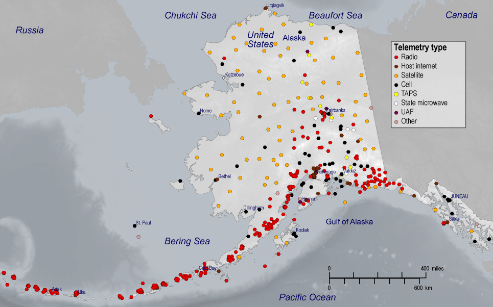
Telemetry types for seismic stations in Alaska by mode of data leaving the site. Some paths may go through additional data hubs or repeaters. Abbreviations: TAPS, Trans-Alaska Pipeline System sites on dedicated T1 line; UAF, University of Alaska Fairbanks internet system.
Reliable broadband cellular coverage in Alaska is only available along the main highway corridors and in larger population centers and therefore continues to be of limited use in the sensor networks. About 24 percent of existing regional seismic sites use cell modem communications, either directly from the site or from a hub. Depending on availability, network operators use cellular mobile service providers such as GCI, AT&T, and Verizon, or smaller local providers. This method is economical and has proved to be mostly reliable, though not completely error-free. Latency and security remain modest issues at some cell sites.
Free internet service provided by host facilities is a cost-effective means of communication. However, commercial internet service providers (ISPs) have different connection requirements and custom network settings that are subject to frequent and unforeseeable changes. This presents cybersecurity and troubleshooting challenges that require more staff time than other networking arrangements. AEC predominantly uses this option for sites located in urban centers and rural communities, and commonly for strong-motion-only installations. Approximately 21 percent of AEC sites use internet connections provided by the landowner.
In the most remote locations satellite is the only telemetry service available. Options include Inmarsat Broadband Global Area Network (BGAN) modems or older stand-alone VSAT earth stations. VSAT service is attractive because it has subscription costs on par with cellular service. However, its high-power requirements (up to 150 watts) significantly restrict its use in remote autonomous installations. About 14 percent of AEC sites rely on VSAT either directly or via data hubs.
Broadband Global Area Network modems require large solar power systems as well, but at about 22 watts are far more energy efficient than VSAT. The major disadvantage of BGAN is the very high subscription cost—about 10 times the cost of cellular or VSAT. To preserve power and return data throughout winter, AEC’s BGAN sites in interior and northern Alaska are set to idle mode most of the time and cycle on to transmit bulk data every half hour or so during the darkest six months of the year. About 22 percent of AEC sites use BGAN modems. To meet the ShakeAlert requirement of continuous, low-latency data transmission these sites would need to have power and (or) telemetry upgrades.
Digital subscriber lines (DSL) and rural broadband are used to transmit data from about 10 percent of AEC sites when no other acceptable options exist due to either cost or power limitations.
Alaska Earthquake Center also benefits from an agreement with the State of Alaska Telecommunications System (SATS) to secure bandwidth on the State’s emergency-responder microwave intranet, and AEC has a dedicated commercial circuit connecting the State facilities in Fairbanks to the UAF campus. This provides extremely reliable and cost-effective communications that are largely insulated from vulnerabilities of the public internet. However, this network is geographically limited and in the near term there is little potential to expand it beyond the 13 key sites that are currently acquired via microwave, some of which are transmitted to the SATS receiver site via radio.
While there is a diversity in telemetry methods for data leaving the field sites, about 85 percent of the data ultimately comes into the AEC data acquisition center via public internet. AEC considers public internet connectivity to be the most pressing vulnerability within the data acquisition system. AEC has begun to do limited direct-to-cloud data acquisition and tested it during recent outages of the data center on campus. The best strategy to guarantee that station data reaches two processing centers is to send two independent data streams; however, limited bandwidth at the station prevents such dual acquisition from being practical for much of the network. Optimizing the balance between AEC on-premises acquisition, cloud acquisition, and failover between the two is an active pursuit.
Other network operators, such as AVO and EarthScope, face the same challenging telemetry environment. AVO relies predominantly on radio communications from field sites to data collection hubs, most of which use VSAT or internet provided by the hosts to reach their data center. EarthScope NOTA GNSS stations use cell communications where they are available and VSAT systems where they are not. Dozens of AEC and NOTA stations share communication pathways.
For effective EEW, ShakeAlert requires low-latency, high-availability, robust telemetry links to deliver data from the field stations to the data centers 24/7/365. Latencies of less than a second are ideal, and up to five seconds can be tolerated. In addition, data return across a network needs to be high. Currently, only about 10 percent of seismic sites in Alaska meet this latency standard and only 20 percent of regional sites have sufficient data availability to support EEW. Therefore, the communication systems for the subset of existing sites that become part of the ShakeAlert system (table 1) would have to be upgraded and significantly improved.
Processing and Alert Center Infrastructure
The Alaska data processing hardware infrastructure would follow the general design for fail-safe operation that is used for the ShakeAlert system on the West Coast. Because it is a three-State system it consists of eight redundant processing threads. Two systems with independent processing threads are hosted at each of the four geographically distributed data centers located in Seattle, Wash.; Moffett Field, Calif.; Berkeley, Calif.; and Pasadena, Calif. (refer to Given and others 2018 for further details). These ShakeAlert production systems are co-located with and directly connected to the ANSS regional seismic network data processing centers.
To meet cyber security requirements and because ShakeAlert Messages are published under USGS Federal authority, real-time ShakeAlert products are served from USGS-owned alert servers that are operated by Federal employees. To ensure failsafe operation, there are six of these public-facing alert servers, two each located in Seattle, Wash.; Moffett Field, Calif.; and Pasadena, Calif. No server exists in Berkeley, Calif., because there are no USGS staff there. All other ShakeAlert data processing functions can be hosted on servers that are operated cooperatively by USGS and its university partners under cooperative agreements.
Continuing this robust architecture model, Alaska would have two geographically separated data centers to support ShakeAlert functions. Each center would have two fully independent processing and alert server threads. One center would be located on the University of Alaska Fairbanks campus, co-located with AEC seismic network operations. The other center could be hosted in the State, either on-premises at an existing government data center, most likely in Anchorage, or by a managed information technology (IT) service provider. The second center could also be hosted in the cloud but there are no large cloud centers like Amazon Web Services, Microsoft Azure, or Google Cloud Platform (GCP) in the State. Alaska’s internet and cellular telecommunications to the lower 48 States are provided by four submarine cables, satellite, terrestrial microwave systems, and an overland fiber-optic cable. Therefore, use of out-of-State cloud services would introduce latency for both data into and alerts out of the system. This dependency may also increase exposure of the system to disruptions in the event of network outages, cyber attacks, and, notably, earthquakes. However, telecommunications options are changing rapidly, for example, with the development of low earth orbit satellite communication constellations. Decisions on the design of the second center could be deferred until the project is being built and options can be reevaluated. The budget allows this flexibility.
System Architecture
The ShakeAlert system in Alaska would use the ShakeAlert system design (fig. 7) developed for the West Coast. As of July 2024, the ShakeAlert system is at version 3.0.1. The ShakeAlert production layer architecture consists of several intercommunicating modules, each with a unique function, which produce data products that are published on alert servers for use by alert delivery partners. The modules communicate using the ActiveMQ (https://activemq.apache.org/) open-source messaging broker.
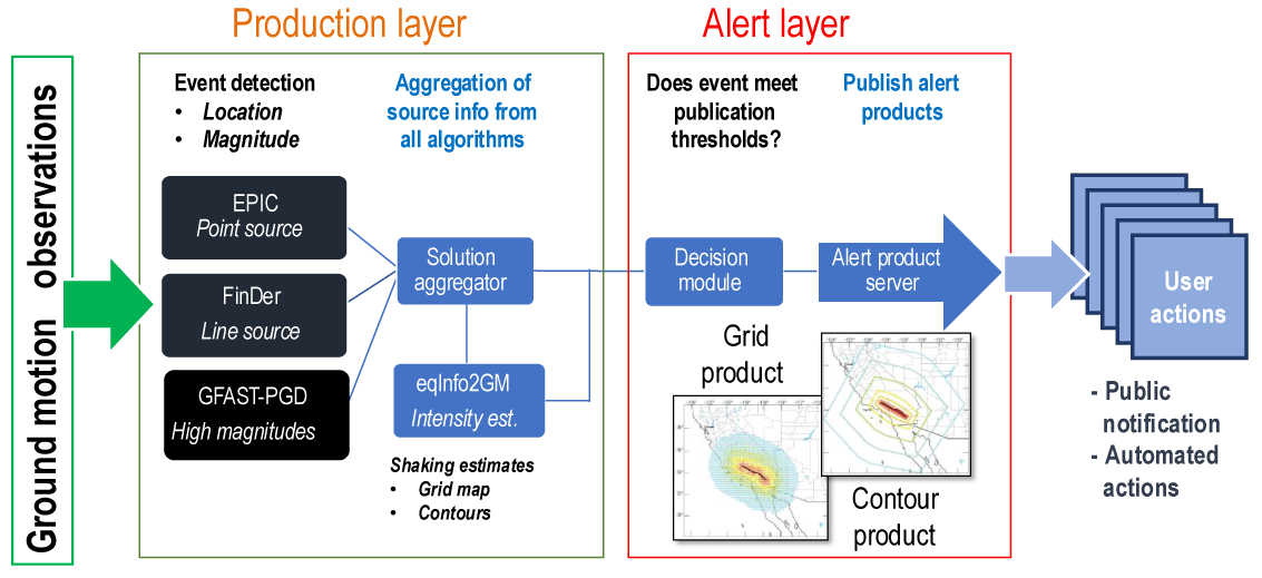
Schematic of the architecture of the ShakeAlert system. Ground-motion data from stations flow through the production layer to the alert layer, which publishes alert products. There would be two redundant data processing centers for Alaska. Abbreviations: EPIC, Earthquake Point-source Integrated Code; FinDer, Finite-Fault Rupture Detector; GFAST-PGD, Geodetic First Approximation of Size and Time Peak Ground Displacement; eqInfo2GM, earthquake information to ground motion.
-
• Data input—Real-time ground-motion data streams are provided by seismic and GNSS networks as described in the preceding sections.
-
• Event source solution algorithms—ShakeAlert originally used two algorithms to determine the location and magnitude of earthquakes (Kohler and others, 2020). A third algorithm that can calculate very large magnitudes with geodetic data was added in 2024 (Murray and others, 2023). The EPIC algorithm (Chung and others, 2019) analyzes ground motions from very small time windows to estimate the event’s epicenter and magnitude. EPIC updates many times per second as more ground-motion data become available. The second earthquake detection algorithm is FinDer (Böse and others, 2023), a portmanteau for finite-fault detector. It estimates not only where an earthquake begins (the point source) but also the length and orientation of the fault rupture as it occurs (the line source). Magnitude is then calculated from length via empirical scaling relationships. FinDer uses a correlation technique to fit ground-motion observations to precalculated fault templates. Like EPIC, it updates as the fault grows and more data becomes available. The third algorithm, GFAST-PGD (Murray and others, 2023), uses GNSS data to measure peak-ground-displacements (PGD) to estimate the magnitude of very large earthquakes (>M7.0) that are above the range of EPIC.
-
• Solution aggregator—This module reviews the results of the contributing algorithms and aggregates them into a single unified estimate. This solution becomes the basis of ShakeAlert information products.
-
• Ground motion estimation—The earthquake information to ground motion (eqInfo2GM) module uses solution aggregator results together with ground-motion prediction equations to estimate the distribution and intensity of shaking that the earthquake will cause and creates the ShakeAlert Message components in the form of Extensible Markup Language (XML) messages.
-
• Decision module—This module reviews the results of the solution aggregator and eqInfo2GM. If an event meets predefined alert thresholds, it will publish the appropriate product XML messages on the alert servers, making them available to users and alert distributors.
-
• Heartbeat aggregator—This module collects system heartbeat and state-of-health messages and summarizes them in an overall system health message for use by system components and users.
These algorithms are always being improved and new techniques are being explored. These are developed both by the USGS and universities under USGS-supported cooperative agreements in a computer development environment that mimics the ShakeAlert production system.
For further details about the ShakeAlert system architecture, refer to Given and others (2018) and Kohler and others (2020).
System Operation, Monitoring, and Code Management
The ShakeAlert West Coast production and alert operations are co-located with ANSS regional seismic network processing centers, and the staff at each center was augmented with additional USGS and university personnel. Likewise, the primary operations center for the ShakeAlert system in Alaska would be performed by USGS and university personnel at the AEC. AEC would collect and monitor the state of health of the expanded sensor network and field telemetry systems and monitor the timeliness of data delivery and the quality of data from its own network as well as data provided by cooperating networks (for example, AVO, NSMP). System performance monitoring, computer system administration, and code management would be performed at AEC in tight collaboration with the West Coast system through ShakeAlert Central (refer to “System Roles and Governance”).
The ShakeAlert System Testing and Performance (STP) platform provides quantitative assessments of algorithm and system performance and is a platform for testing modifications and improvements to the algorithms and their run-time configurations (Cochran and others, 2018). The STP platform does pseudo-real-time replays of about 200 U.S. and global earthquakes, large synthetic events, and examples of noise and other problematic ground motion records. No changes are deployed to the ShakeAlert system without first being thoroughly tested on the STP platform and running for at least two weeks on real-time test servers. Any changes to the ShakeAlert system needed for Alaskan operation would be proven via the STP process before deployment.
ShakeAlert Message Components
The ShakeAlert system publishes three real-time information components (fig. 8) that are disseminated to authorized users via alert servers. These products are described in detail in Given and others (2018). The Event Source Message provides the earthquake’s hypocenter location, depth, and magnitude. For moderate to large earthquakes (>M6), it also includes an estimated fault rupture extent depicted as a series of line or rectangular segments. The Contour Message encapsulates all the information in the Event Source Message along with ground-motion estimates represented by nested contours (eight-sided polygons) that delineate areas anticipated to experience peak ground shaking at each Modified Mercalli Intensity (MMI) level of MMI 3 or higher. Regions predicted to have minimal or no shaking (<MMI 3) are excluded. The Map Message incorporates all the information in the Event Source Message plus ground-motion estimates, expressed as expected MMI, peak ground acceleration (PGA), and peak ground velocity (PGV) values, at points spaced in a regular grid with a spacing of 0.2 x 0.2 degrees (approximately 20 x 20 km). The grid’s extent is determined by the earthquake’s magnitude and the affected area. Users can interpolate between points to estimate shaking at specific locations. All messages also include quality metrics, the number of reporting stations, and observed peak ground motions at triggered stations.
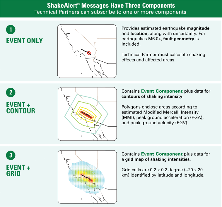
Description and illustration of the three types of real-time information products in ShakeAlert Messages published to the alert servers for use by authorized users. Colored contours/colored cells in panels 2 and 3, respectively, are coded according to estimated shaking intensity at a location, with red colors indicating higher intensities and blue lower. Figure derived from Given and others (2018). Abbreviations: ~, approximately; km, kilometer.
Alert Delivery
Part of the ShakeAlert mission is to provide ShakeAlert-powered alerts free of charge to the public via third-party partnerships with delivery providers and to specialized users, including commercial service providers, for use in end-user applications.
The USGS does not have the mission or the infrastructure and expertise to deliver mass alerts directly to the public or to provide site-specific technology to take automatic actions. Thus, the ShakeAlert strategy for alert distribution and use is to enlist USGS-licensed technical partners that have the technical ability and resources to provide ShakeAlert-powered products and services to their clients. ShakeAlert Messages (the data product of the ShakeAlert system) are published by the USGS and provided to technical partners. A technical partner enters into a Pilot License Agreement with the USGS with the goal of developing ShakeAlert-powered products and services, such as a cell phone app to alert people to take protective action, or automatic systems to take actions such as slowing a train, actuating valves, or placing machines in safe positions.
Technical partners include private for-profit companies, public entities, and nonprofits that span multiple industries and sectors. Once a partner successfully demonstrates they can deliver a beneficial implementation, they receive a License to Operate, which allows them to deploy and market it. By building systems that deliver ShakeAlert-powered products and services, technical partners can help to save lives and minimize injuries and reduce earthquake damage to property and infrastructure.
The USGS is an authorized Alert Originator with FEMA’s national Integrated Public Alert and Warning System (IPAWS), which delivers potentially life-saving information to the public through mobile phones, using Wireless Emergency Alerts (WEA). This is the same system that local authorities can use to send America’s Missing: Broadcast Emergency Response (AMBER) alerts and notifications for severe weather, wildfires, tsunamis, and other hazards.
Delivery of alerts to the public may experience some challenges in Alaska for a fraction of the population. Telecommunications infrastructure is concentrated in areas where people live. Some people may be outside of these areas and outside the reach of cell phone-based notifications. Fifth-generation (5G) service is expanding rapidly in Alaska but is currently limited to urban areas. Successful delivery mechanisms would need to be compatible with current and evolving cellular technologies.
As noted in appendix 1, many Alaska stakeholders engaged by the USGS in this planning process mentioned challenges with the public’s perception of the NOAA tsunami warning system’s performance and also that these views may extend to all hazard alerts delivered by WEA. This issue has been explored in a report from the Government Accountability Office (GAO; GAO, 2023) which found that the primary challenge was not attributable to the WEA system, but instead to NOAA’s tsunami alerts that were not geotargeted narrowly enough to coastal areas, resulting in extensive over-alerting inland where there was no hazard. In addition, the GAO report noted the possibility of under-alerting if people do not receive WEAs in areas with limited cellular infrastructure or if they do not have a WEA-capable cell phone. Such alert-delivery issues are not unique to Alaska, but significant public education could help inform expectations of the capabilities and limits of the ShakeAlert system. Of note, the recommended protective actions taken for EEW (personal and automated actions that are executed in a matter of seconds) have different consequences than the evacuations initiated by tsunami warnings, which may influence public attitudes toward ShakeAlert WEA alerts.
Alert Release Thresholds
The ShakeAlert system publishes data streams consisting of ShakeAlert Messages for use by licensed technical partners as described above. These messages would only be used to generate alerts if they meet science-based quality standards and reach predefined threshold levels for providing timely EEW alerts for damaging shaking. The primary goal of the ShakeAlert system is to facilitate timely alert delivery for a target threshold of MMI 6 and greater shaking, for earthquakes of M5.5 and larger. MMI 6 is the intensity level at which potentially damaging shaking occurs. Research has demonstrated that in order to reliably meet this target in a timely manner, messages must be published for a shaking intensity level that is lower than the target: this is the “alert-delivery threshold” (for example, Minson and others, 2018; Meier and others, 2020). The current West Coast alert thresholds are provided in figure 9. Decisions on the thresholds that would be appropriate for Alaska would be made jointly by the USGS and the State of Alaska.
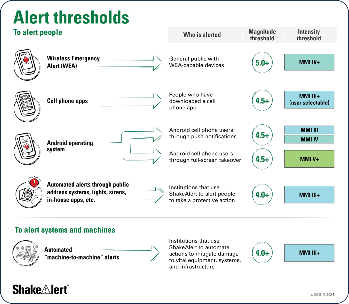
Description of ShakeAlert-powered alert-delivery thresholds for various use cases on the West Coast. Abbreviation: MMI, Modified Mercalli Intensity.
Communication, Education, Outreach, and Technical Engagement
The USGS’s 2018 Revised Technical Implementation Plan for the ShakeAlert System—An Earthquake Early Warning System for the West Coast of the United States (2018 Technical Implementation Plan) notes that “EEW alerts are useless if people do not know how to respond to them” (p. 2) and that “extensive communication, education, and outreach (CEO) for both public and institutional users is needed for ShakeAlert to have maximum beneficial impact” (p. 26; Given and others, 2018).
ShakeAlert’s Communication, Education, Outreach, and Technical Engagement (CEO&TE) efforts are crucial for the success of the System. The ShakeAlert CEO&TE Community (formerly called the Joint Committee for Communication, Education, Outreach, and Technical Engagement) coordinates the development, implementation, and evaluation of efforts to create effective methods for alerting people and to advance technologies for taking automated actions. This multi-organizational group integrates end-user needs, social science research, alerting best practices, and lessons learned from successful ShakeAlert implementations with the goal of reducing property damage and protecting lives by getting people to take a protective action (such as drop, cover, and hold on) if they feel shaking or receive a ShakeAlert-powered alert.
The States of California, Oregon, and Washington participate in and contribute to ShakeAlert implementation on the West Coast as they do for routine seismic monitoring and other earthquake hazard mitigation and education activities in their respective States. These education programs can be effectively leveraged by integrating ShakeAlert information into existing earthquake educational materials and activities. To this end, the USGS has developed a messaging toolkit that provides State agencies with resources to develop and deliver effective public education and training programs about ShakeAlert. The toolkit includes messaging templates, training materials, graphics, and case studies.
The USGS strategy is to create messaging content and a framework for effective coordination but not to directly carry out public education and training activities related to ShakeAlert, with the expectation that professionals in State agencies would integrate ShakeAlert into earthquake education programs that already exist in each State. The USGS expects this same model to work in Alaska to ensure the population has the relevant information to use ShakeAlert.
Social science contributes to ShakeAlert CEO&TE efforts in at least three distinct ways. From development through its operational phase, the ShakeAlert system has relied on social science to inform decisions, such as setting appropriate alert delivery thresholds, composing alert messages, and communicating technical aspects of the ShakeAlert system. Second, social science provides a research-based foundation for the development of education and training products, programs, and services. Finally, ShakeAlert research contributes to the larger body of social science literature (for example, risk communication, science education, and human behavior) and the greater community of practice both inside of and external to the USGS.
Alaska benefits from a population that generally appreciates the hazards posed by earthquakes, which facilitates the engagement of Alaskans in natural hazards education. The primary State contributors to earthquake awareness are currently the Alaska Division of Homeland Security and Emergency Management (DHS&EM), AEC, and the Alaska Division of Geological and Geophysical Surveys (DGGS). Additional organized outreach comes from the National Tsunami Warning Center and the USGS Alaska Science Center. Many CEO programs exist across these organizations. Public-facing efforts include publications such as the collaborative “Are You Prepared for the Next Big Earthquake in Alaska?” (https://earthquake.alaska.edu/sites/default/files/are-you-prepared_Nov2016-web.pdf), emergency preparedness fairs, public service announcements, the traveling Shake Cabin, and strong social media across all of these organizations. These organizations utilize school programs targeting the education of high school students. School programs can be an excellent way to get information to families. On the private level, the Alaska Partnership for Infrastructure Protection Program (coordinated by DHS&EM) provides a pathway to get ShakeAlert information to corporate users. These types of programs would need substantial new coordination and new Alaska-specific ShakeAlert materials to execute an EEW CEO campaign. However, many of the collaborations and program pathways are already in place. Rather than building a wholesale new ShakeAlert CEO effort, this messaging can be delivered largely through existing pathways. This would require interagency coordination and new investment by the State of Alaska.
System Roles and Governance
The details of the ShakeAlert governance strategy are described in Given and others (2018). ShakeAlert is a multi-State system led by the USGS, a Federal Government bureau, in coordination with State and university partners. The USGS is also coordinating with international authorities in Canada and Mexico. ShakeAlert is part of the ANSS and is managed like other important projects of the USGS Earthquake Hazards Program (EHP). The USGS EHP has overall responsibility for the ShakeAlert system and works closely with cooperating project partners to achieve the goals of the system. Core system management and operations, testing and certification, coordination of communication, education, and outreach activities, and overall project management, is performed by USGS project staff under the direction of the national EEW coordinator. This group, known as ShakeAlert Central, is located primarily in Pasadena, Calif. Under the expanded ANSS governance, the ShakeAlert project has several technical working groups and an internal USGS working group, which provides USGS project oversight and identifies issues to be considered by the external working group. The Alaska component of the ShakeAlert system would be integrated with this management structure.
The System in Alaska would be developed and operated as an expansion of ANSS ShakeAlert project which leverages ANSS and other Federal and State investments in seismic and geodetic monitoring. In Alaska, ShakeAlert would be operated cooperatively, with the AEC at the University of Alaska Fairbanks in the lead role. The ShakeAlert university partners’ work is defined and supported through cooperative agreements with the USGS, and work is coordinated by several working groups under the overall guidance of the ShakeAlert Executive Committee. The development, testing, and operation of the ShakeAlert system in Alaska would be led by ShakeAlert Central and carried out by the USGS EHP, ANSS, and its partner universities through cooperative agreements and grants and through internal USGS projects.
The ShakeAlert CEO&TE Community and its working groups include representatives from the USGS, State emergency management agencies and geological surveys, and other experts in emergency management and hazard communications. As part of their activities, the ShakeAlert CEO&TE Community coordinates ShakeAlert’s technical engagement, social science research, and the development of messaging and educational materials. They have researched and delivered several evidence-based recommendations about risk communications, alert signals and sounds, user interaction, and hazard communication. They also organize user meetings such as sector symposia, which focus on raising awareness of ShakeAlert’s benefits for target groups and recruit and manage commercial and non-commercial pilot users.
State Partners
The Federal Government expects the benefiting States to participate in and contribute toward ShakeAlert implementation and operation as they do for routine seismic monitoring and other earthquake hazard mitigation activities. This expectation includes financial cost share in the operations and maintenance of the ShakeAlert network. This expectation also includes support for CEO&TE efforts, which are most effectively executed as State-level activities. The West Coast States of California, Oregon, and Washington have all contributed to ShakeAlert build-out. California, through the Governor’s Office of Emergency Services provides substantial funding and oversight for ongoing operation and maintenance, and the State enacted legislation in 2013, Senate Bill 135, and 2016, Senate Bill 438, that made EEW a priority (California State Senate, 2013, 2016). The Federal Government would work with the State of Alaska to determine an appropriate level of State participation in and financial contribution to the ShakeAlert system.
The USGS strategy is to coordinate, but not carry out, public education and training related to ShakeAlert, with the expectation that the benefiting States would leverage existing earthquake education programs by integrating ShakeAlert with them. Through the ShakeAlert CEO&TE Community, the USGS has guided the formation of State- and region-specific committees to ensure these stakeholders participate in ShakeAlert communication, education, and outreach planning. This includes State emergency management departments and geological surveys, as well as commissions, committees, nonprofits, and other associations focused on earthquake hazards.
Research and Development Specific for ShakeAlert in Alaska
ShakeAlert is a constantly evolving system that adapts and improves through ongoing research and development (R&D). As it is extended to benefit Alaska, R&D would be particularly important to identify system performance issues and develop strategies to address them. The system must be adapted to the topology and capabilities of Alaska sensor networks and the distribution of population centers and relevant earthquakes, which are different than on the U.S. West Coast. Challenges are anticipated for the system’s performance in areas where station coverage would be limited by geography, weather, or logistic obstacles. Ground-motion prediction equations specific to the geology of Alaska would be needed to accurately estimate the areas and intensity of shaking for potentially damaging events. Alaska is particularly vulnerable to large subduction zone earthquakes, but not many have been well recorded, so there are few good ground-motion records for testing and tuning of the system. Therefore, generation of synthetic datasets could help understand and improve the performance of ShakeAlert in subduction zones. R&D would be needed to improve the capabilities of the system to determine larger magnitudes more accurately, for example by developing fault-specific templates for FinDer (Böse and others, 2023) tailored to large Alaskan earthquakes and integrating the GFAST-PGD module (Murray and others, 2023) for large Alaskan earthquakes.
Research and development would also be needed to improve detection and characterization of earthquakes that occur outside the Alaska network but affect population centers, particularly for earthquakes offshore along the Alaska-Aleutians subduction zone. Synthetic tests demonstrate that small aperture arrays can improve out-of-network locations; therefore, ShakeAlert has begun a project to collect a 2-year dataset from a temporary array on the Pacific coast of the Olympic Peninsula to test the ability of coastal arrays to improve its performance offshore. If successful and cost-effective, arrays could be strategically added to the system.
There are also new emerging technologies that have the potential to improve and advance EEW and could be areas of further research. For example, distributed acoustic sensing (DAS) holds promise for the offshore region, but the technology is still in its early research stage and the capabilities and costs are not well known. Other emerging technologies include use of purpose-built low-cost sensors, Internet of Things (IoT) devices, ground velocities derived from real-time GNSS data, seismogeodetic techniques, machine learning, and likely more that may arise. Operational implementation of resulting research would likely require additional funding.
Finally, Alaska’s population is made up of different cultures and languages, and understanding these differences can influence the design of CEO&TE efforts. Social science research can help to assess the public’s perceptions of hazards in Alaska, determine how to best reach them with ShakeAlert educational messages, and understand their attitudes about alerts and warnings, especially in relation to NOAA tsunami warnings.
Cost Estimates for Alaska Phase 1
The cost estimates were made using the framework of the ShakeAlert work breakdown structure (WBS) dictionary and are broken down into three WBS component levels. The estimated one-time cost of building out the Phase 1 ShakeAlert system in Alaska is $65.8 million, and the annual operations and maintenance cost of the completed system is estimated to be $12 million per year (table 2). Estimates were made in 2024 dollars, so costs associated with activities in outyears must be adjusted for inflation. Specifically, experience with ShakeAlert on the West Coast has shown that cost-of-living wage increases erode the ability to cover operational costs over time, so annual adjustments for wage, equipment, and other and cost increases are vital for proper long-term operation and maintenance. The figures in table 2 represent the estimated costs over and above the annual funding from Federal and State sources that currently supports seismic monitoring efforts in Alaska. The Federal Government would work with the State of Alaska to determine an appropriate level of State participation in and financial contribution to the ShakeAlert system. Additional investments that may be needed by third parties to implement ShakeAlert automated actions are not included in this cost estimate.
Table 2.
Summary of estimated capital and operations and maintenance costs for the Phase 1 ShakeAlert expansion to Alaska.[Capital costs would cover the build-out of the system; operations and maintenance costs would cover support of the system once it is fully complete]
Capital Costs for Alaska Phase 1
The $65.8 million capital cost estimate (in 2024 dollars) for completing the Phase 1 ShakeAlert system in Alaska is shown in table 2. These costs would complete the build-out of the 450-station seismic network, install GNSS receivers at a subset of seismic stations, purchase and install computers and servers. It would also support targeted R&D and CEO&TE needs in the early stage of build-out to help assess and refine the system design.
To arrive at a gross average cost, the budget also includes institutional overhead rates, as appropriate.
Operations and Maintenance Budget for Alaska Phase 1
The annual recurring cost of long-term operations and maintenance of the Phase 1 ShakeAlert system in Alaska infrastructure component would be $12 million per year (in 2024 dollars) when completed. The USGS would work with the State of Alaska to determine an appropriate cost share for this investment.
The operations and maintenance budget for seismic stations is based on an analysis of the historic average per-station support cost within ANSS networks in Alaska. This was then multiplied by the number of new ShakeAlert stations in Alaska. Note that it assumes current operations and maintenance support for certain existing networks from all associated sources would continue at current levels—and keep up with inflation—and support operations and maintenance of pre-build-out infrastructure. The estimate includes personnel and travel for field maintenance, commercial telemetry costs, ongoing fees and renewal of site licenses, permits, and environmental approvals, as well as personnel for management, data handling, IT support, and quality control. It also includes equipment replacement costs (equipment amortization) on a 10- year life cycle for field equipment and associated infrastructure, and a 5-year life cycle for data acquisition computers. Overhead was factored in to arrive at a gross number.
Cost Estimate Assumptions
The following assumptions have been made in developing this budget:
-
• Federal and Alaska State funding that supports the ANSS networks in Alaska will remain at current levels and keep up with inflation.
-
• Funding that supports cooperating seismic networks like AEC, AVO, and NSMP will remain at current levels and keep up with inflation.
-
• While this plan does not rely on continued support for both the Alaska State ACORN and the NSF NOTA geodetic networks, their inclusion would enhance geodetic capabilities.
-
• Public education programs will be carried out by Alaska State organizations with coordination and content support from the USGS.
-
• With the exception of IPAWS/WEA, public alerting and other ShakeAlert implementations will be carried out by USGS-licensed technical partners at their expense.
Timeline
This plan lays out an ambitious timeline that builds on experiences learned during ShakeAlert implementation in California, Oregon, and Washington. Figure 10 shows a scenario that assumes an initial year for project initiation during which processes and contracts would be put in place, followed by full annual costs at the operations and maintenance level (table 2). Any timeframe for achieving operational status for ShakeAlert in Alaska would depend on annual levels of both State and Federal investment. The more quickly the annual funding required to cover costs is reached, the more quickly the system would become operational. If the full costs are never covered, then the area of coverage would be scaled back accordingly.
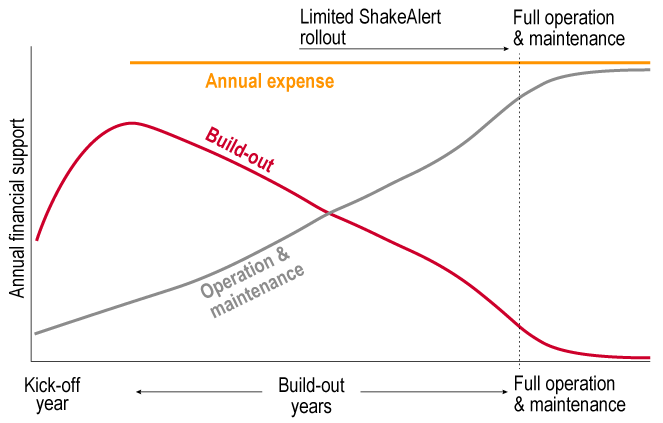
This scenario illustrates how the costs shift from system build-out (capital costs) to operation and maintenance over time. Limited rollout of public alerting could begin when seismic network density in a selected region is built out sufficiently to ensure timely and reliable earthquake early warning (EEW).
During the first few years, the majority of the annual costs would go toward installing new stations, upgrading existing stations, and hardening communications. This build-out would begin in Southcentral Alaska. In subsequent years, the network would be expanded westward toward Kodiak, eastward to Prince William Sound, and northward to Fairbanks. The final stage would encompass southeast Alaska. As the ShakeAlert network grows, the annual costs would shift incrementally from build-out to operations (fig. 10). Once the south-central portion of the network is sufficiently built out to ensure timely and reliable EEW, ShakeAlert could begin public alerting in a limited region. If cost estimates are fully covered in year 1, this could occur in year 4. As the network expands to encompass earthquakes originating in different locations, the ShakeAlert region would also be expanded.
ShakeAlert is a State-Federal partnership. State investment is essential for building public awareness campaigns. This investment makes it possible to coordinate multiple State entities including emergency managers, geologic surveys, and universities. It also allows the ShakeAlert effort to adapt to the unique needs of the region. The USGS would work with the State of Alaska to determine an appropriate cost share for this investment.
Conclusion
This Phase 1 implementation plan describes the design and costs for the U.S. Geological Survey Earthquake Hazards Program, along with its partners in Government and industry, to initially expand the ShakeAlert earthquake early warning system on the West Coast to high-risk regions in Alaska. In addition to potentially reducing deaths and injuries caused by earthquake shaking, the system can improve community resilience, provide rapid post-event situational awareness, and present new opportunities to educate the public and decision makers about earthquake hazards.
The ShakeAlert system can potentially provide seconds of warning to people and automated systems before strong shaking arrives. With just a few seconds of warning, users can take a variety of protective actions. The discussions with Alaska stakeholders (appendix 1) identified personal protective actions as the highest priority. People would have advance warning to drop, cover, and hold on or move away from dangerous areas. Protecting personnel would have wide benefits both for the general population and across many specific groups, such as schools, hospitals, airports, military bases, ports, utilities, the energy industry, the tourism industry, and the emergency response community. Identifying users interested in implementing ShakeAlert-powered automated actions in Alaska would require further investigation, but the automated action most frequently identified in stakeholder discussions was having alerts delivered to an organization’s personnel or emergency operations center via a notification system. Finally, ShakeAlert-powered alerts can also be particularly valuable in the aftermath of large earthquakes when aftershocks shake weakened structures, which can endanger rescue and recovery workers who are in hazardous situations.
Earthquake early warning has limitations. False and missed alerts are possible, and there may be little or no advance warning near the earthquake’s epicenter, where shaking is usually strongest. Additionally, providing adequate warning time for strong shaking requires setting an alert delivery threshold at a lower target of estimated shaking. Decisions on alert-delivery thresholds in Alaska would be decided jointly by the U.S. Geological Survey and the State.
The U.S. Geological Survey and partners would leverage the existing Advanced National Seismic System infrastructure, expertise, and partnerships in Alaska. The system would require 450 seismic stations: 270 new stations, 160 upgraded stations, and 20 existing stations. The system would also include real-time global navigation satellite system (GNSS) stations, with a particular focus on improving warnings for great-sized subduction zone earthquakes. The Phase 1 plan would be ambitious to implement, especially given the challenges with Alaska telecommunications, travel, weather, and cost.
Initial implementation would first target the highest risk region of south-central Alaska. Build-out would then proceed southwestward toward Kodiak, eastward to Prince William Sound, and northward to Fairbanks. The final stage would encompass build-out in southeast Alaska. The phased rollout of general public alerting in one of these regions could begin as soon as the system is sufficiently built out, alerts can meet appropriate standards, mass alerting technologies are ready, and there are materials to educate the public adequately about how to respond to alerts.
References Cited
Alaska Seismic Hazards Safety Commission, 2016, The benefits of enhanced earthquake monitoring and potential earthquake early warning in Alaska—A stakeholder survey: Office of Governor Bill Walker, developed by the Alaska Seismic Hazards Safety Commission, accessed October 11, 2024, at https://seismic.alaska.gov/download/ashsc_meetings_minutes/ASHSC_Benefits_EQ_Monitoring_6_27_16.pdf.
Böse, M., Andrews, J., Hartog, R., and Felizardo, C., 2023, Performance and next‐generation development of the Finite‐Fault Rupture Detector (FinDer) within the United States West Coast ShakeAlert warning system: Bulletin of the Seismological Society of America, v. 113, no. 2, p. 648–663, accessed October 10, 2024, at https://doi.org/10.1785/0120220183.
California State Senate, 2013, An act to add and repeal Section 8587.8 of the Government Code, relating to earthquake safety: California Government Code, bill 135, chap. 342, accessed February 10, 2025, at https://leginfo.legislature.ca.gov/faces/billTextClient.xhtml?bill_id=201320140SB135.
California State Senate, 2016, An act to amend Section 8587.8 of, and to add Sections 8587.11 and 8587.12 to, the Government Code, relating to earthquake safety: California Government Code, bill 438, chap. 803, accessed February 10, 2025, at https://leginfo.legislature.ca.gov/faces/billNavClient.xhtml?bill_id=201520160SB438.
Chung, A.I., Henson, I., and Allen, R.M., 2019, Optimizing earthquake early warning performance—ElarmS-3: Seismological Research Letters, v. 90, no. 2A, p. 727–743, accessed October 10, 2024, at https://doi.org/10.1785/0220180192.
Cochran, E.S., Kohler, M.D., Given, D.D., Guiwits, S., Andrews, J., Meier, M.-A., Ahmand, M., Henson, I., and Hartog, R., Smith, D., 2018, Earthquake early warning ShakeAlert system—Testing and certification platform: Seismological Research Letters, v. 89, no. 1, p. 108–117, accessed October 11, 2024, at https://doi.org/10.1785/0220170138.
Federal Emergency Management Agency [FEMA], 2023, Hazus estimated annualized earthquake losses for the United State, FEMA P-366: Federal Emergency Management Agency, 96 p., accessed October 11, 2024, at https://www.fema.gov/sites/default/files/documents/fema_p-366-hazus-estimated-annualized-earthquake-losses-united-states.pdf.
Given, D.D., Allen, R.M., Baltay, A.S., Bodin, P., Cochran, E.S., Creager, K., de Groot, R.M., Gee, L.S., Hauksson, E., Heaton, T.H., Hellweg, M., Murray, J.R., Thomas, V.I., Toomey, D., and Yelin, T.S., 2018, Revised technical implementation plan for the ShakeAlert system—An earthquake early warning system for the West Coast of the United States: U.S. Geological Survey Open-File Report 2018–1155, 42 p., accessed October 11, 2024, at https://pubs.usgs.gov/publication/ofr20181155. [Also available at https://doi.org/10.3133/ofr20181155. Supersedes USGS Open-File Report 2014–1097.]
Government Accountability Office [GAO], 2023, Emergency alerts—NOAA should take additional actions to help ensure tsunami alerts reach those at risk: Government Accountability Office, GAO-23-105961, accessed October 11, 2024, at https://www.gao.gov/products/gao-23-105961.
Kohler, M.D., Smith, D.E., Andrews, J., Chung, A.I., Hartog, R., Henson, I., Given, D.D., de Groot, R., and Guiwits, S., 2020, Earthquake early warning ShakeAlert 2.0—Public rollout: Seismological Research Letters, v. 91, no. 3, p. 1763–1775, accessed October 11, 2024, at https://doi.org/10.1785/0220190245.
McGuire, J.J., Smith, D.E., Frankel, A.D., Wirth, E.A., McBride, S.K., and de Groot, R.M., 2021, Expected warning times from the ShakeAlert earthquake early warning system for earthquakes in the Pacific Northwest (ver. 1.1, March 24, 2021): U.S. Geological Survey Open-File Report 2021–1026, 37 p., accessed October 11, 2024, at https://pubs.usgs.gov/publication/ofr20211026.
Meier, M.-A., Kodera, Y., Böse, M., Chung, A., Hoshiba, M., Cochran, E., Minson, S., Hauksson, E., and Heaton, T., 2020, How often can earthquake early warning systems alert sites with high-intensity ground motion?: Journal of Geophysical Research: Solid Earth, v. 125, no. 2, article e2019JB017718, 17 p., accessed October 11, 2024, at https://doi.org/10.1029/2019JB017718.
Melbourne, T.I., Szeliga, W.M., Marcelo Santillan, V., and Scrivner, C.W., 2021, Global navigational satellite system seismic monitoring: Bulletin of the Seismological Society of America, v. 111, no. 3, p. 1248–1262, accessed October 11, 2024, at https://doi.org/10.1785/0120200356.
Minson, S.E., Meier, M.-A., Baltay, A.S., Hanks, T.C., and Cochran, E.S., 2018, The limits of earthquake early warning—Timeliness of ground motion estimates: Science Advances, v. 4, no. 3, article eaaq0504, 10 p., accessed October 11, 2024, at https://doi.org/10.1126/sciadv.aaq0504.
Murray, J.R., Crowell, B.W., Murray, M.H., Ulberg, C.W., McGuire, J.J., Aranha, M.A., and Hagerty, M.T., 2023, Incorporation of real-time earthquake magnitudes estimated via peak ground displacement scaling in the ShakeAlert earthquake early warning system: Bulletin of the Seismological Sociey of America, v. 113, no. 3, p. 1286–1310, accessed October 11, 2024, at https://doi.org/10.1785/0120220181.
Ochoa Chavez, J.A., and Doser, D.I., 2020, Geophysical analysis of the 30 July 1972 Sitka, Alaska, earthquake sequence: Geosphere, v. 16, no. 3, p. 712–722, accessed October 11, 2024, at https://doi.org/10.1130/GES02144.1.
Petersen, M.D., Shumway, A.M., Powers, P.M., Field, E.H., Moschetti, M.P., Jaiswal, K.S., Milner, K.R., Rezaeian, S., Frankel, A.D., Llenos, A.L., Michael, A.J., Altekruse, J.M., Ahdi, S.K., Withers, K.B., Mueller, C.S., Zheng, Y., Chase, R.E., Salditch, L.M., Luco, N., Rukstales, K.S., Herrick, J.A., Girot, D.L., Aagaard, B.T., Bender, A.M., Blanpied, M.L., Briggs, R.W., Boyd, O.S., Clayton, B.S., DuRoss, C.B., Evans, E.L., Haeussler, P.J., Hatem, A.E., Haynie, K.L., Hearn, E.H., Johnson, K.M., Kortum, Z.A., Kwong, N.S., Makdisi, A.J., Mason, H.B., McNamara, D.E., McPhillips, D.F., Okubo, P.G., Page, M.T., Pollitz, F.F., Rubinstein, J.L., Shaw, B.E., Shen, Z.-K., Shiro, B.R., Smith, J.A., Stephenson, W.J., Thompson, E.M., Thompson Jobe, J.A., Wirth, E.A., and Wittter, R.C., 2024, The 2023 US 50-State National Seismic Hazard Model—Overview and implications: Earthquake Spectra, v. 40, no. 1, p. 5–88, accessed October 11, 2024, at https://doi.org/10.1177/87552930231215428.
U.S. Geological Survey, 2017, Advanced National Seismic System—Current status, development opportunities, and priorities for 2017–2027 (ver. 1.1, July 2017): U.S. Geological Survey Circular 1429, 32 p., accessed October 11, 2024, at https://doi.org/10.3133/cir1429.
Appendix 1. Summary of Stakeholder Engagement Meetings
Stakeholder Discussions
The U.S. Geological Survey (USGS) Earthquake Hazards Program (EHP) and staff from Corner Alliance conducted a series of unstructured conversations with individuals from 26 organizations (refer to tables 1.1 and 1.2) representing key Alaska stakeholder groups and Alaska monitoring networks. The Alaska Division of Geological and Geophysical Surveys and others supported the effort by helping identify organizations of interest and providing their contact information. The purpose of the engagement was to gain insight into stakeholder expectations, recommendations, and concerns regarding the potential extension of the ShakeAlert earthquake early warning (EEW) system to Alaska. This engagement also provided Alaska organizations an opportunity to have a voice in the development of the implementation plan at the early stage, when the design and priorities were still being defined.
Table 1.1.
Stakeholder engagement meetings.Table 1.2.
Stakeholder engagement meetings: monitoring network subset.Most stakeholder meetings were scheduled for 60 minutes. The conversations began with the USGS providing an overview of ShakeAlert, followed by discourse on a set of themes tailored to the expertise of individuals and (or) organizations. These were then followed by open discussions. Discussion themes covered a range of topics, including current earthquake response capabilities; the potential benefit of ShakeAlert; research items; communication, education, and outreach needs; monitoring capabilities; the straw man proposal for the ShakeAlert area of coverage for Phase 1 in Alaska; and funding sources for current networks. Discussions were conducted virtually and were automatically transcribed; no audio or visual was recorded. Transcript data from the stakeholder discussion was analyzed using content analysis to identify, code, and categorize participant input (refer to table 1.3).
Table 1.3.
Themes identified in Stakeholder Engagement Meetings.[Abbreviations: %, percent; USGS, U.S. Geological Survey; NOAA, National Oceanic and Atmospheric Administration]
Perceived Benefits of Extending ShakeAlert to Alaska
Overall, the possibility of expanding the ShakeAlert EEW system to Alaska was well received, with stakeholders expressing a perceived benefit for Alaska, their organization, or both in 89 percent of engagement meetings. Only one engagement meeting raised opposition to the expansion, with a stakeholder stating a preference that increased Federal funding be used instead to support other types of hazard mitigation programs in Alaska. The USGS provided technical information on the characteristics of EEW alerts, which give seconds of potential warning time, depending on several factors such as the location of the receiver relative to the location of the earthquake, the magnitude of the earthquake, and the monitoring network coverage. One stakeholder made the following comment:
“Having an early warning system here helps us out tremendously because the more you can mitigate the disaster or make the disaster more known to folks so that they can take precautions, the easier our job is here.”
Personnel Protection
Stakeholders predominantly identified the primary use case for ShakeAlert as being for personnel protection—such as people receiving a Wireless Emergency Alert on their cell phone with information to take protective action and “drop, cover, and hold on.”
Automated Actions
The type of automated action most frequently discussed was having ShakeAlert-powered alerts delivered to an organization’s personnel or emergency operations center via a notification system. Some organizations already use mass notification services (such as AtHoc or Command and Control Incident Management Emergency Response Application [C2IMERA]). Note that alerts from the ShakeAlert system on the West Coast are being delivered to some hospitals and schools in California, Oregon, and Washington for delivery on their public address (PA) systems. Stakeholders were also interested in whether ShakeAlert alerts could be delivered over an organization’s radio communications network to reach personnel out in the field.
Only a few stakeholders identified ShakeAlert use cases for implementing ShakeAlert-powered automated actions for infrastructure protection in Alaska. Some Alaska infrastructure is already designed to be resilient to earthquakes (for example, the Alyeska pipeline), and given the State’s small population, Alaska has a less developed infrastructure overall compared to the U.S. conterminous West Coast.
Several discussions mentioned that the ShakeAlert-powered automated actions on the West Coast are used to open firehouse doors to prevent them from getting stuck in an earthquake, though stakeholders noted that functionality would need modification for rural Alaska regions without 24/7 station staff. Also mentioned were automated actions to open aircraft hangar doors, since protection of air asset functionality is critical for Alaska—for example, air transport is essential for transporting patients to appropriate hospital facilities, and Alaska only has two level II trauma centers, and fixed wing transport to Seattle, Washington, is required to access a level I trauma center.
Interest was expressed in learning about how ShakeAlert is currently being used on the West Coast to slow and stop trains (for example, Bay Area Rapid Transit [BART] and Metrolink in California). Another idea discussed was the automated transfer of certain key infrastructure from commercial power to standby power, since the power grid could fluctuate and go offline in an earthquake.
Tsunami Warning
The risk from earthquake-generated tsunamis was viewed by Alaska stakeholders as being higher than the risk from earthquake shaking alone, although this perception is anecdotal, since tsunami risks have not been fully quantified for comparison. Stakeholders were thus hopeful that the monitoring network improvements for ShakeAlert might also benefit National Oceanic and Atmospheric Administration (NOAA) tsunami warning capabilities.
Advanced National Seismic System Products
Many stakeholders already depend on earthquake information from the USGS Advanced National Seismic System (ANSS) and the Alaska Earthquake Center. The improved network functionality for ShakeAlert could benefit regular ANSS situational awareness products. For example, the improved strong-motion station coverage from ShakeAlert could provide a benefit by increasing the accuracy of ShakeMap, a tool currently utilized by several stakeholders (including the Alyeska pipeline, which uses ShakeMap to make decisions on inspections after an earthquake). The USGS also discussed with stakeholders the various products and tools available from ANSS.
Phase 1 Coverage
The majority of stakeholders that were shown a draft Phase 1 coverage map similar to figure 2 were agreeable with a strategy of covering the main metropolitan areas in the initial phase. The Phase 1 plan was seen by stakeholders as ambitious, especially given the challenges with Alaska telecommunications, travel, and the expected cost. EEW is more effective in protecting people who are at higher risk from the presence of modern technological systems like trains, large buildings, and so on. Earthquake risk from shaking will be lower in rural areas than it is in metropolitan areas due to the lack of such infrastructure and the dangers presented by it. On the U.S. West Coast, the station coverage is similarly denser in high-risk metropolitan areas. Rural areas are dependent on services from metropolitan areas and could receive indirect benefit from protecting these regions.
A minority of stakeholders voiced concerns with the ShakeAlert coverage map. One issue is that Alaska Native village communities live in some of the remote areas that are not covered in the current draft, so access concerns could be triggered by the design. Also expressed was the sentiment that small villages are an essential part of Alaska and should not be overlooked. Given such concerns, this plan also includes support to add 20 strong-motion sensors to some existing seismic stations on the Alaska Peninsula and Aleutian Islands in order to improve traditional earthquake monitoring for this region and to collect data that could help in the evaluation of any possible future ShakeAlert expansion. The lessons learned if this plan is implemented could also be used when considering subsequent phases to expand EEW beyond Phase 1 in Alaska in the future.
Concerns Regarding the Potential Expansion of ShakeAlert in Alaska
Several areas of concern were raised regarding the potential implementation of ShakeAlert in Alaska, as described below.
Communications Coverage Limitations
A common concern raised by stakeholders was that people in some parts of Alaska might not have telecommunications coverage to enable receiving ShakeAlert Messages on a cell phone. The coverage of Alaska’s telecommunications infrastructure is focused on the main metropolitan areas and becomes extremely limited-to-nonexistent in the more sparsely populated and remote parts of Alaska. Cellular outages are also not uncommon. It was noted that some people may need to use Wi-Fi or Voice over Internet Protocol (VoIP) to get cell service, or even use satellite internet or a satellite phone to make calls. Some people may have no cell or internet capabilities whatsoever. Radios are also used by many rural villages for everyday communications with each other. The Aleutian Islands were specifically mentioned as having high tsunami hazard but limited communications, and island by island they have different methods of receiving information.
National Oceanic and Atmospheric Administration Tsunami Warnings
Many stakeholders mentioned issues with public alert fatigue in Alaska related to NOAA tsunami warnings sent by Wireless Emergency Alerts (WEA). They noted challenges with public perceptions of the tsunami warning system’s performance, because of several instances where areas were over-alerted (over-alerting means that an alert is received by a population it is not intended for, such as people who are not in an area at risk of a tsunami). One stakeholder noted that in July 2023, news media reported a traffic fatality in Kodiak during a tsunami evacuation (https://alaskapublic.org/2023/07/18/kodiak-resident-dies-in-hit-and-run-during-saturdays-tsunami-evacuation/).
Some stakeholders perceived NOAA tsunami warning over-alerting as being related to fundamental issues with WEA performance in Alaska, and they expressed concern that these issues would similarly occur with ShakeAlert WEA messages. However, in response to its advisory board recommendations, NOAA has been working on strategies to avoid over-alerting (see for example GAO, 2023). It should be noted that NOAA has the ability to utilize device-based geofencing to improve alert precision, whereas ShakeAlert has a Federal Communications Commission (FCC) waiver to not use geofencing because it slows the time for delivery too severely for EEW to be useful.
Additionally, it was strongly recommended that ShakeAlert and NOAA’s tsunami warning centers coordinate to address how to present messages that would not confuse the public. The public in Alaska is very knowledgeable about the tsunami hazard, and it was expected that users who live near the coast would be immediately looking for tsunami information if they received a ShakeAlert-powered alert.
Over-Alerting and Alert Thresholds
Stakeholders expressed concern about over-alerting and the number of alerts that users might receive. Alaska experiences much higher rates of earthquakes than the U.S. West Coast States, so stakeholders were concerned about the potential alert fatigue in Alaska that could cause users to ignore alerts and fail to take protective action. Stakeholders expressed that ShakeAlert thresholds in Alaska should be designed with the State’s specific higher earthquake frequency, hazard, and risk in mind.
Vulnerable Populations
Non-English speakers and tourists were identified as two key vulnerable populations. One stakeholder noted that they “have over 90 languages spoken in Anchorage schools” and that ShakeAlert Communication, Education, Outreach, and Technical Engagement (CEO&TE) should consider language barriers. One stakeholder from the Alaska Native Tribal Health Consortium commented that people from native communities may be turned off and not pay attention unless CEO materials were translated into the major Alaska Native languages.
Alaska also has a large tourist economy, with one stakeholder noting a 50 percent increase in business during peak tourist season. As an illustration of this vulnerability, an Alaskan community of 750 people can be impacted by arrivals of 3 or 4 cruise ships of 5,000 people each that saturate the cell towers and need to be served by the community’s 1 volunteer ambulance.
Stakeholders voiced concerns that tourists would not have the same understanding of EEW and that alerts received on tourists’ cell phones could result in confusion or inappropriate actions. Several stakeholders also identified Anchorage’s homeless community as a vulnerable population.
Communication, Education, and Outreach
Stakeholders commented that communication, education, and outreach would be needed for the successful implementation of ShakeAlert. Both the Alaska Division of Geological and Geophysical Surveys (DGGS) and the Alaska Division of Homeland Security and Emergency Management (DHS&EM) expressed support for integrating ShakeAlert CEO into their current outreach work.
Some stakeholders expressed that the public in Alaska is already more informed about the risks from earthquakes and tsunamis than on the U.S. West Coast, owing to the higher frequency of events in Alaska. It was noted that about one-seventh of the population in Alaska participates in the annual ShakeOut earthquake drills. Some school districts also incorporate earthquake education and outreach materials in their curriculums. There is not an earthquake teacher guide, but there is a volcano teacher guide for Alaska. Alaskan children are taught from a young age about earthquakes and this approach could be a vital pathway for educating adults on earthquake hazards and protective actions.
Those who cover hazard CEO functions in Alaska noted that face-to-face contact was more successful when implementing other programs in the State:
“Alaskans like putting faces to projects especially when we visit those communities that are under 300 people . . . they feel like us as the State are going above and beyond just going to these smaller communities just to present on, you know, earthquake hazards, tsunami hazards, and speaking to their kids. No one likes mail.”
One stakeholder expressed concern about Alaska’s current capabilities for the coordination of activities among the different emergency managers. Owing to the size of the state, Alaska’s coordination can be fragmented, and this stakeholder encouraged better coordination across jurisdictions for information-sharing purposes and hoped that the arrival of ShakeAlert might provide a unifying force.
The USGS was also informed that although many Alaskans have historical or familial knowledge of earthquake and tsunami hazards, there is also a lot of turnover in Alaska, and so these stories may not get passed down. There can be a high turnover rate with local governments and the Tribal governments, which requires continued CEO efforts and resources to educate governments about hazards.
Some communities may have two sets of government, one for the local communities and another specifically for the Tribal communities. The annual Alaska Federation of Natives (AFN) meeting in Anchorage was noted as a great way to meet people within the Alaska Native community, such as by setting up an outreach booth. If ShakeAlert in the future is drafting educational materials for Alaska, it may be helpful to include a Federal Emergency Management Agency (FEMA) Region 10 Tribal liaison as a reviewer.
Reference Cited
Government Accountability Office [GAO], 2023, Emergency alerts—NOAA should take additional actions to help ensure tsunami alerts reach those at risk: Government Accountability Office, GAO-23-105961, accessed October 15, 2024, at https://www.gao.gov/products/gao-23-105961.
Appendix 2. Interagency Workshop: Earthquake Early Warning in Alaska—What Would It Take
Table 2.1.
List of attendees at Earthquake Early Warning in Alaska—What Would It Take.Table 2.2.
List of presenting institution and corresponding subject.[AEC, Alaska Earthquake Center; DHS&EM, Division of Homeland Security and Emergency Management; NOAA, National Oceanic and Atmospheric Administration]
Key Terms and Abbreviations
ACORN
Alaska’s Continuously Operating Reference Network, a global navigation satellite system network
AEC
Alaska Earthquake Center, University of Alaska Fairbanks
AEL
annualized earthquake loss
AELR
annualized earthquake loss ratio
AK
Network code for the Alaska Geophysical Network, operated by AEC
ANSS
Advanced National Seismic System
ASHSC
Alaska Seismic Hazards Safety Commission
AVO
Alaska Volcano Observatory
BGAN
Broadband Global Area Network, a satellite-based data communication network
CEO
Communications, Education, and Outreach
CEO&TE
Communications, Education, Outreach, and Technical Engagement
CISNDisplay
An integrated web-enabled earthquake notification system designed to provide earthquake information for emergency response
DGGS
Alaska Division of Geological and Geophysical Surveys
DHS&EM
Alaska Division of Homeland Security and Emergency Management
DSL
digital subscriber line, a type of internet connection that uses the voice frequency of telephone lines to send and receive internet data and traffic
EarthScope Consortium
National Science Foundation-funded facility and research program that operates Network of the Americas geodetic network
EAS
Emergency Alert System
EEW
earthquake early warning
EHP
USGS Earthquake Hazards Program
EPIC
Earthquake Point-source Integrated Code, ShakeAlert’s earthquake point-source solution algorithm
eqInfo2GM
earthquake information to ground motion
FEMA
Federal Emergency Management Agency
FinDer
Finite-Fault Rupture Detector, ShakeAlert’s earthquake line-source solution algorithm
GAO
Government Accountability Office
GCI
General Communication Corp
GCP
Google Cloud Platform
GFAST-PGD
Geodetic First Approximation of Size and Time Peak Ground Displacement, ShakeAlert algorithm to estimate large earthquake magnitudes using GNSS geodetic data
GNSS
global navigation satellite system
IoT
Internet of Things
IPAWS
FEMA’s Integrated Public Alert and Warning System
ISP
internet service provider
latency
Any delay in the processing chain from the time an earthquake begins until end users receive data or alerts
LtO
license to operate
M
magnitude
MMI
Modified Mercalli Intensity
NEHRP
National Earthquake Hazards Reduction Program
NOAA
National Oceanic and Atmospheric Administration
NOTA
Network of the Americas geodetic network
NSF
National Science Foundation
NSMP
U.S. Geological Survey National Strong Motion Project
O&M
operation and maintenance
PA
public address system
PNSN
Pacific Northwest Seismic Network
QuakeFeed
A cell phone application that presents earthquake data from government and news sources
R&D
research and development
SATS
State of Alaska Telecommunications System
ShakeAlert
The USGS earthquake early warning system that is operating on the West Coast (Washington, Oregon, California)
ShakeCast
USGS product that delivers ShakeMap products to institutional users, enabling them to assess the impact of earthquakes on their infrastructure
ShakeMap
USGS product that uses data from regional seismic networks to provide near-real-time maps of ground motion and shaking intensity within minutes following significant earthquakes
STP
ShakeAlert System Testing and Performance platform
UAF
University of Alaska Fairbanks
USGS
U.S. Geological Survey
VoIP
Voice over Internet Protocol
VSAT
very small aperture terminal, a satellite-based data communication network
WBS
work breakdown structure
WEA
Wireless Emergency Alerts, system that uses cellular broadcast technology in commercial cell systems to send mass alerts to the public
Publishing support provided by the Science Publishing Network,
Denver and Reston Publishing Service Centers
For more information about this publication, contact:
Senior Science Advisor for Earthquake and Geologic Hazards,
Earthquake Hazards Program
U.S. Geological Survey
Mail Stop 905
12201 Sunrise Valley Drive
Reston, VA 20192
For additional information, visit: https://www.usgs.gov/programs/earthquake-hazards/
Disclaimers
Any use of trade, firm, or product names is for descriptive purposes only and does not imply endorsement by the U.S. Government.
Although this information product, for the most part, is in the public domain, it also may contain copyrighted materials as noted in the text. Permission to reproduce copyrighted items must be secured from the copyright owner.
Suggested Citation
Wolfe, C.J., Ruppert, N.A., Given, D.D., West, M.E., Thomas, V.I., Murray, J.R., and Grapenthin, R., 2025, Phase 1 technical implementation plan for the expansion of the ShakeAlert earthquake early warning system to Alaska: U.S. Geological Survey Open-File Report 2025–1003, 32 p., https://doi.org/10.3133/ofr20251003.
ISSN: 2331-1258 (online)
Study Area
| Publication type | Report |
|---|---|
| Publication Subtype | USGS Numbered Series |
| Title | Phase 1 technical implementation plan for the expansion of the ShakeAlert earthquake early warning system to Alaska |
| Series title | Open-File Report |
| Series number | 2025-1003 |
| DOI | 10.3133/ofr20251003 |
| Publication Date | February 27, 2025 |
| Year Published | 2025 |
| Language | English |
| Publisher | U.S. Geological Survey |
| Publisher location | Reston VA |
| Contributing office(s) | Earthquake Hazards Program |
| Description | viii, 32 p. |
| Country | United States |
| State | Alaska |
| Online Only (Y/N) | Y |